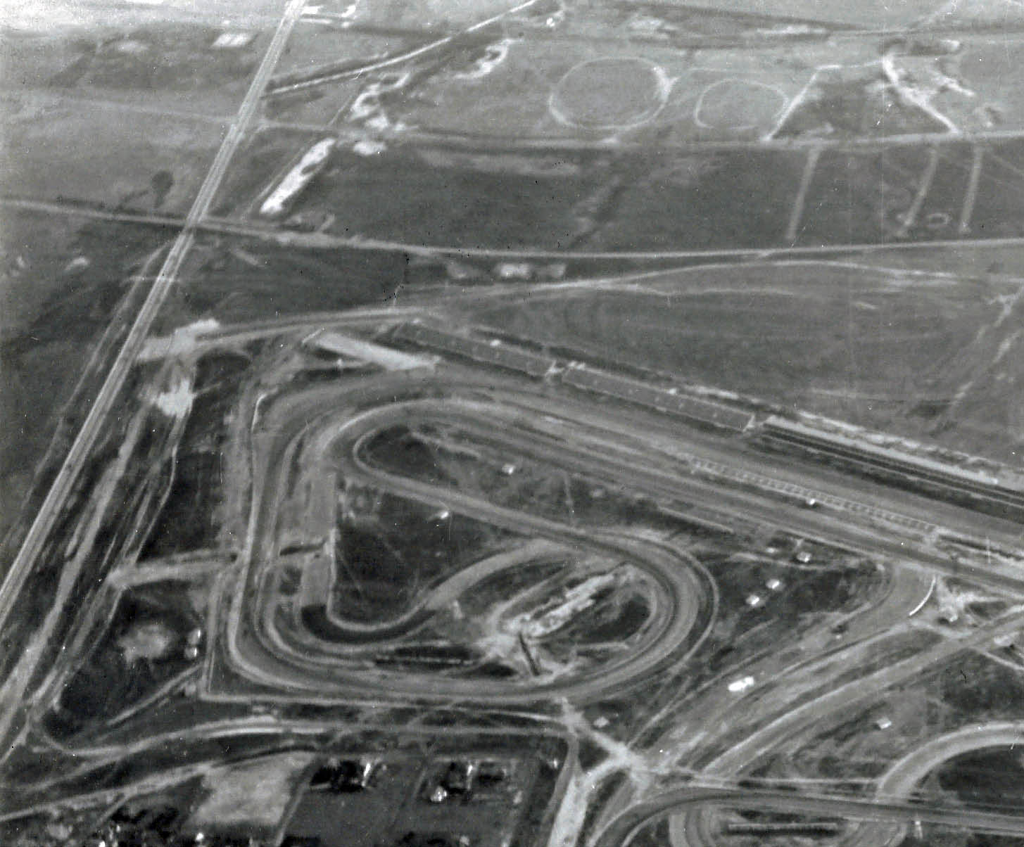
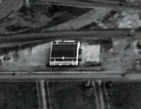
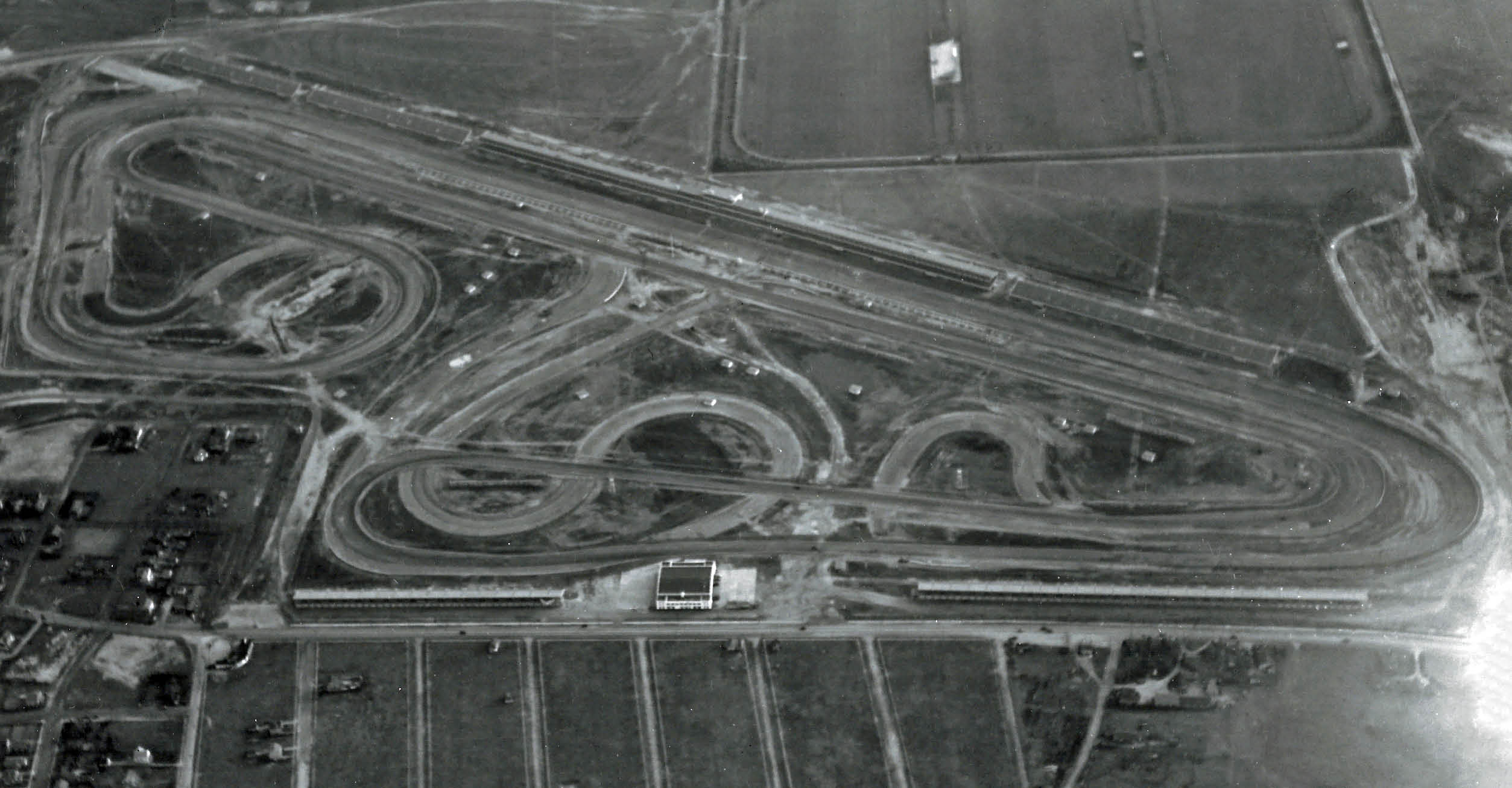
Mystery Foto #15 Solved: An Aerial of Roosevelt Raceway and Westbury Circa 1937-1939

Preservation Long Island challenged you to identify this aerial from their archives.
Mystery Foto questions:
- Identify the location and the orientation of the photographer and the major roads seen in the Mystery Foto
The airplane was over Westbury looking south. Roads are documented in the below Comments.
- Identify the structures associated with the Long Island Motor Parkway and the Vanderbilt Cup Races
Motor Parkway: Merrick Avenue Motor Parkway Bridge can be seen next to Meadow Brook Lodge, Roosevelt Field Bridge next to its twin Meadow Brook Hunt Club bridge and special Gate #7 used as the entrance to Roosevelt Raceway.
Vanderbilt Cup Races: Roosevelt Raceway-site of the 1936 and 1937 Vanderbilt Cup Races, Merrick Avenue Motor Parkway Bridge- used for the 1908, 1909 and 1910 Vanderbilt Cup Race courses.
- What was the history of the large white building in the middle of the aerial?
An original hangar of the Roosevelt Field airfield an later the Roosevelt Aviation School. In 1936- 1952, the administration building and bar/restaurant for Roosevelt Raceway.
- Which aerial survey team took this photo?
Braman and Butters
- What year was the aerial taken? Provide a rationale.
1937-1939. Rationale: The condition of the Roosevelt Raceway track.
Comments (14)
Congrats to Joseph Osterle, Al Prete, Greg O., George Philippides, Lee Chambers, Paul Parisi, Steve Lucas, Art Kleiner, Frank Femenias and Dick Gorman for identifying Roosevelt Raceway.
Kudos to George Philippides, Paul Parisi and Frank Femenias for the wonderful jpegs! Much appreciated!.
Be Safe, Stay Healthy, Save Lives,
Howard
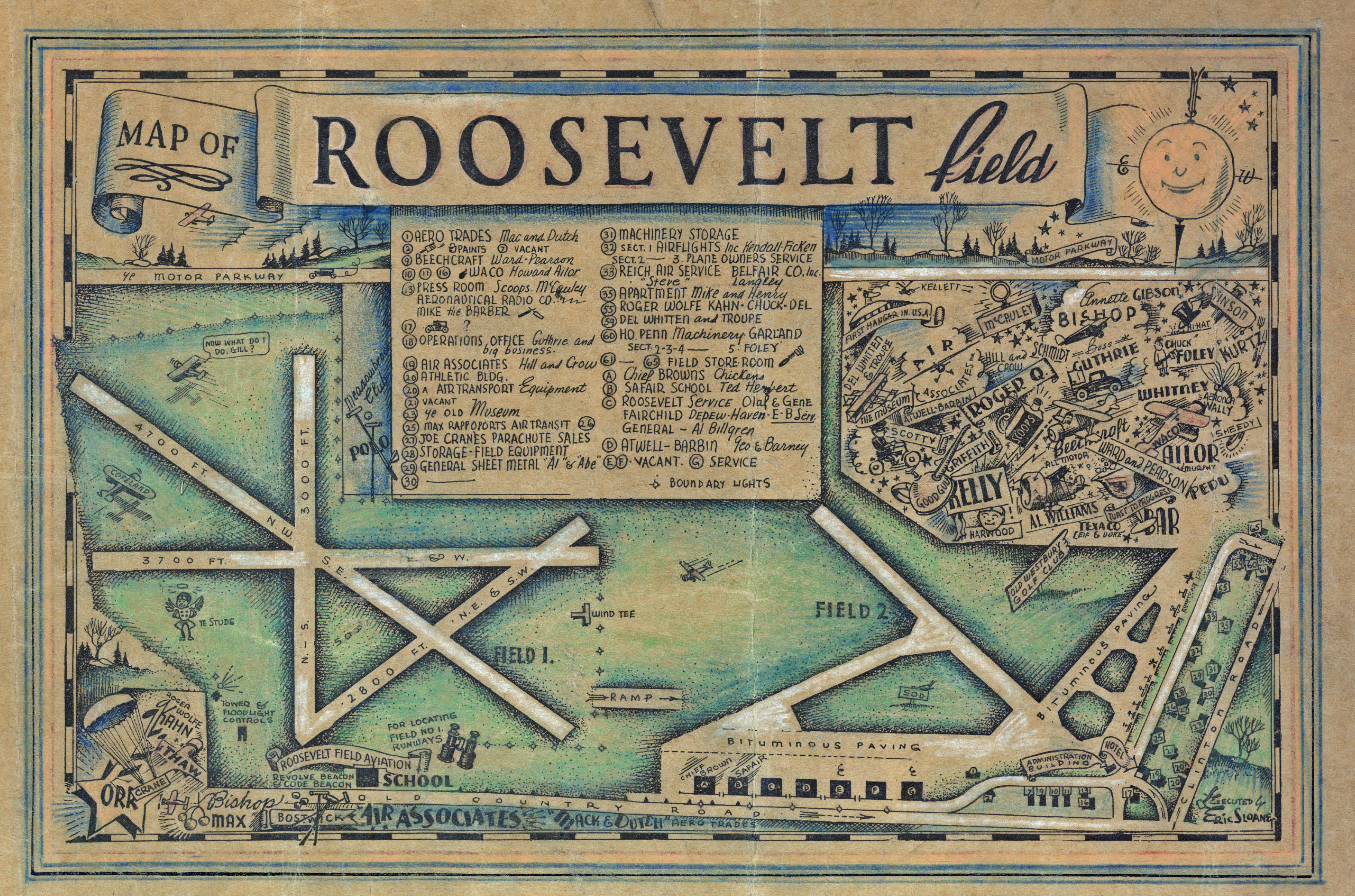
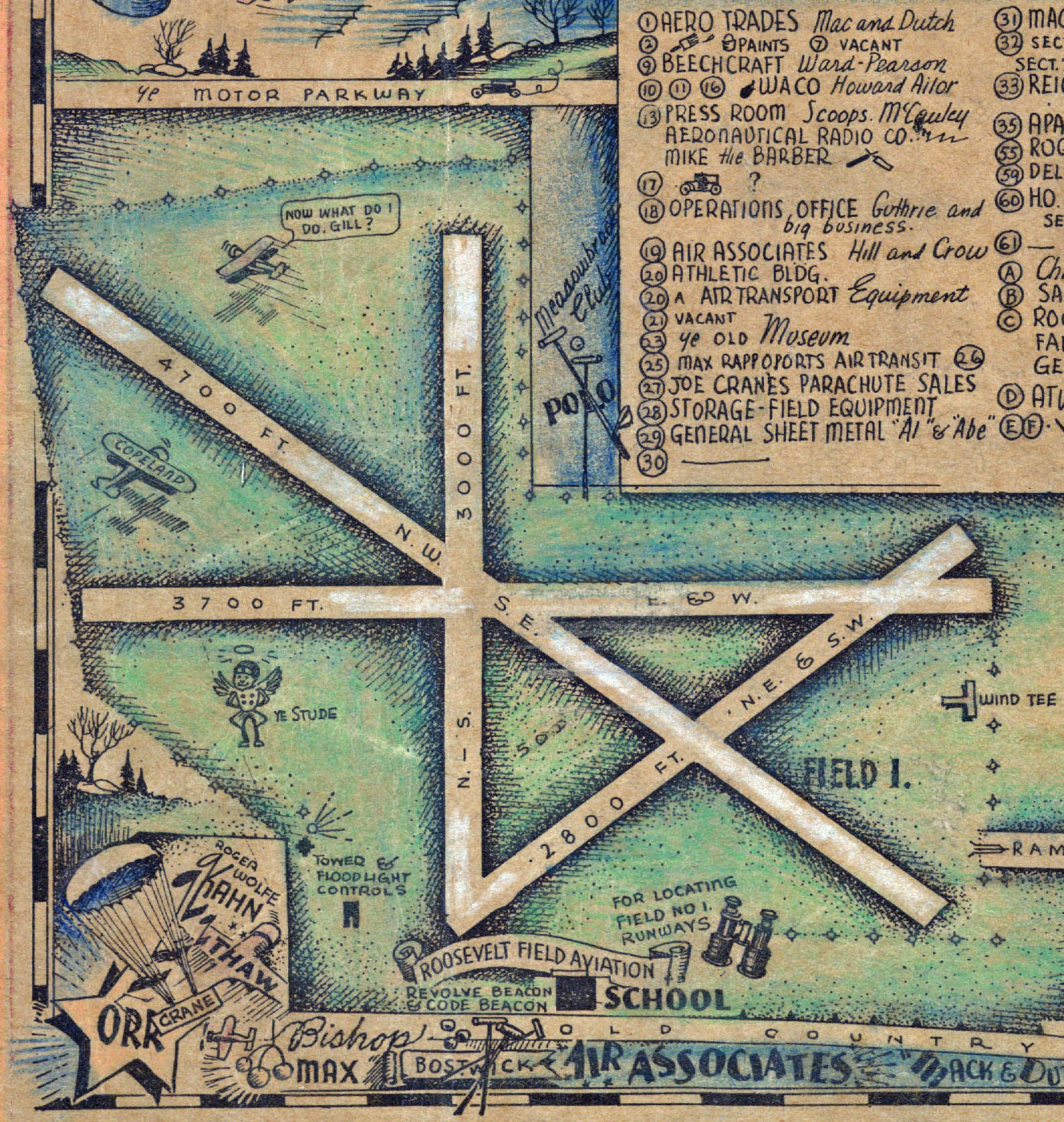
Close-Ups
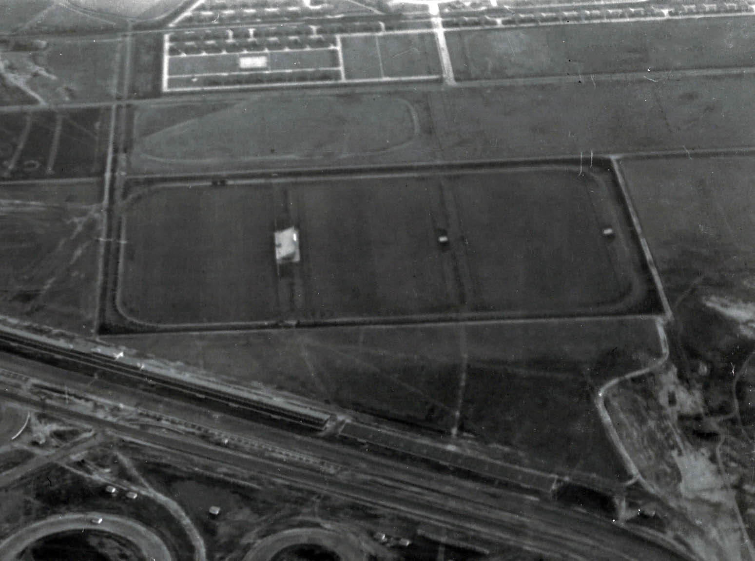
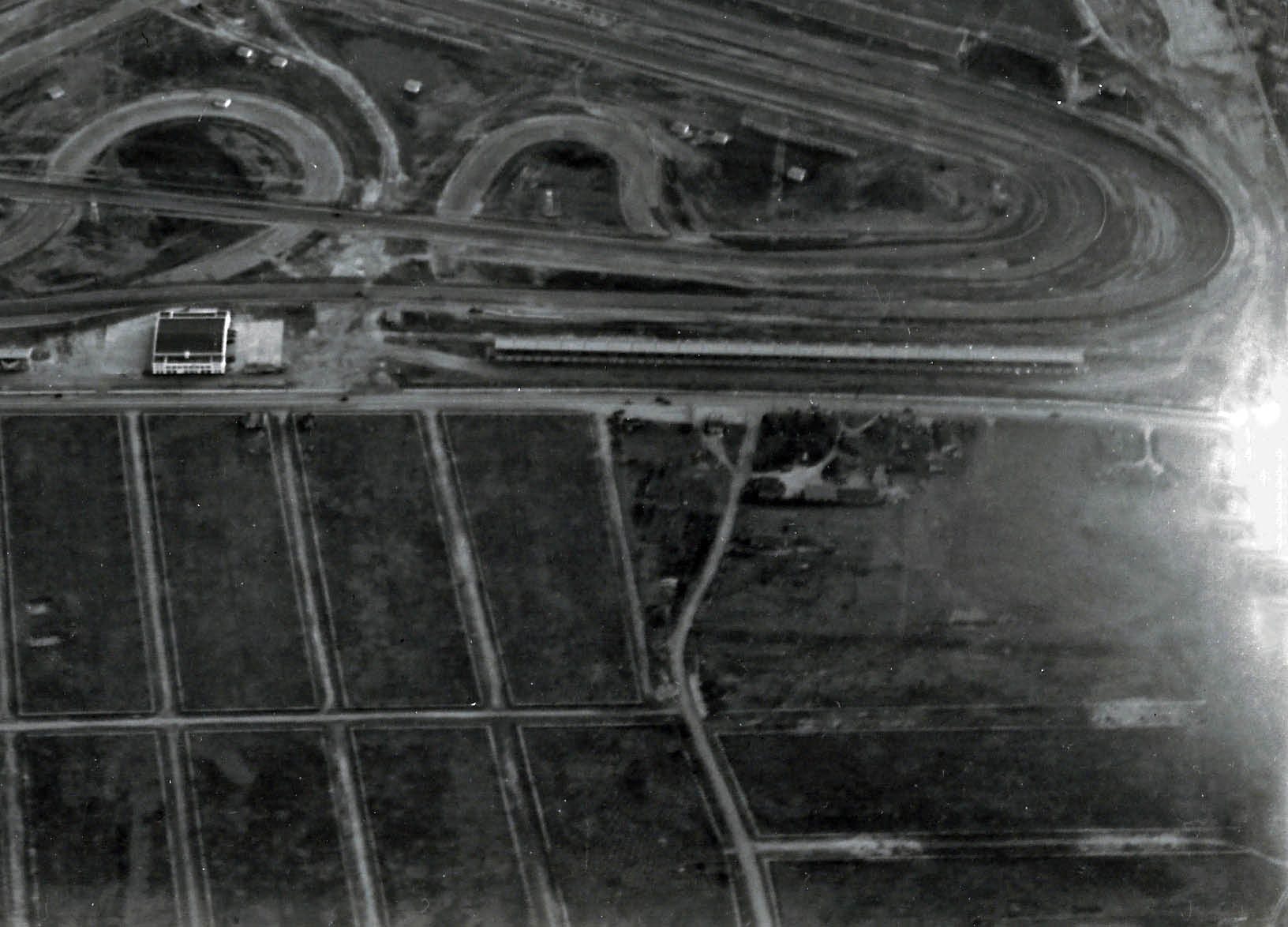
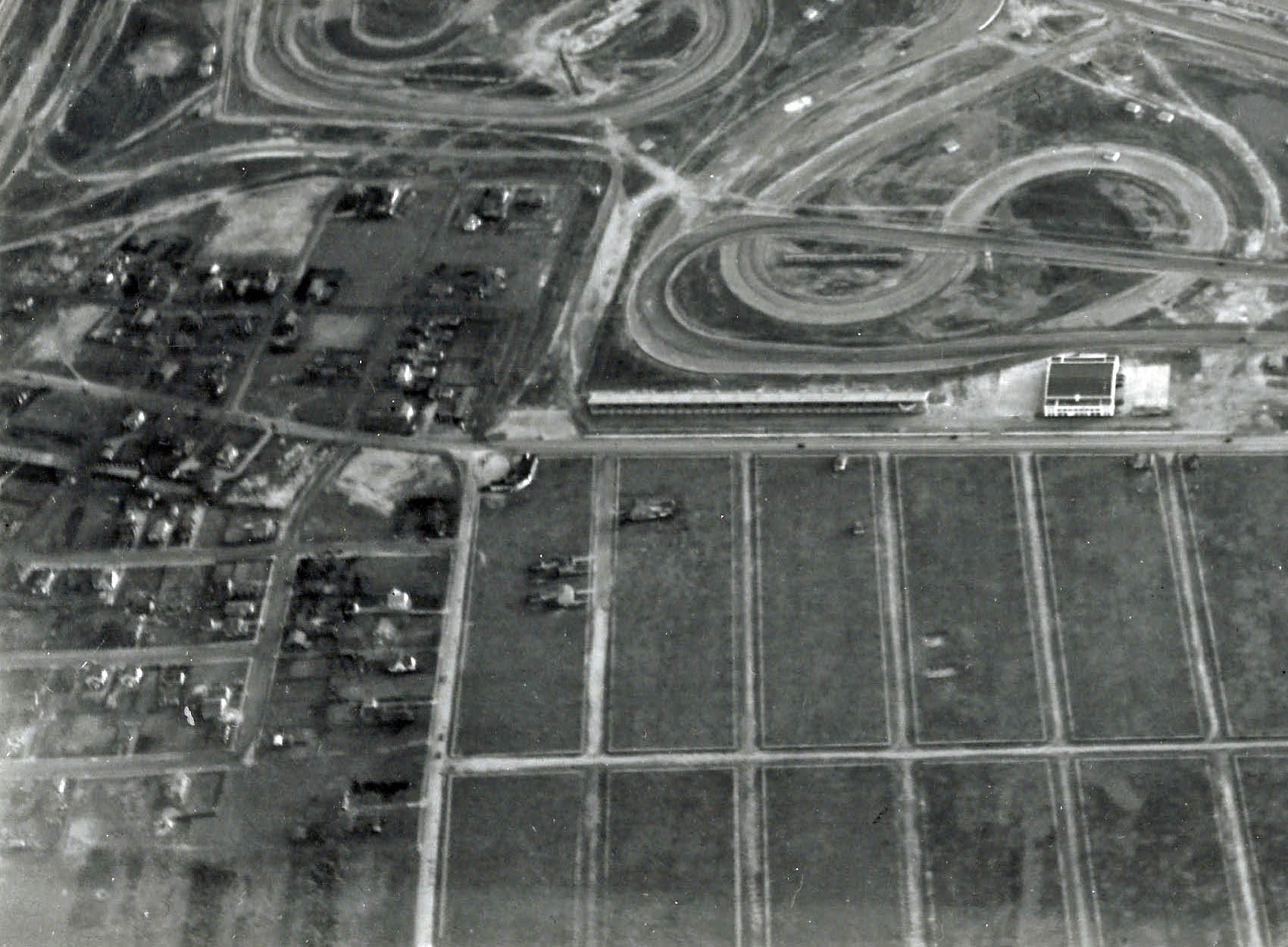
Roosevelt Aviation School
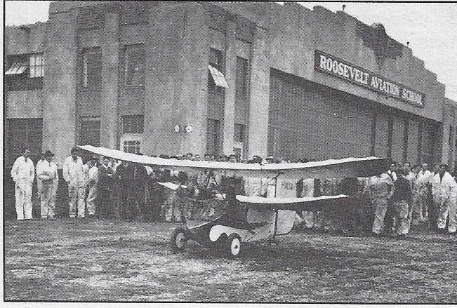
Roosevelt Aviation School (1935)


Comments
Roosevelt Raceway. Home of the VCR in the 1930’s. I can see the LIMP Roosevelt Field bridge. And its twin sitting right next to it. I can see the Meadowbrook lodge. I can see the LIMP bridge over Merrick Rd. I am looking south. I do not know the building on Old Country Rd, but I do remember it still being there.
It’s the Roosevelt Raceway auto track, where the 1936 and 1937 Vanderbilt Cup Races were held. The photographer is looking south.
To the left (east) is Merrick Avenue (aka Post, Whaleneck, Barnum Ave.) Traveling south on Merrick, you cross the Motor Parkway, then Stewart Avenue. The road branching to the southwest at the extreme top left of the Foto is what I believe to be Westbury Avenue, part of which still exists in Hempstead Village.
To the north of the track are the “stadium” stands on either side of the white building. North of the stands is Old Country Road, and north of that is a grid of streets in Westbury Village (the crooked one at lower right is Carle Road).
To the south of the track are the grandstands, and south of the grandstands (the big rectangle) is the Meadow Brook Polo Club.
I have no clue about the white building. The aerial survey team has probably been mentioned in posts past, but I don’t know who they are. My guess is the picture was taken around 1938, after the second VCR and before the track was re-configured for Midget racing in 1939. Also, no houses on the Westbury streets says probably pre-WWII.
Identify the location and the orientation of the photographer and the major roads seen in the Mystery Foto
-Roosevelt Raceway along Old Country Rd horizontally lower center, Merrick Ave/Whaleneck Ave along left edge, Ellison rd lower left, -looking Southward
Identify the structures associated with the Long Island Motor Parkway and the Vanderbilt Cup Races
-1936/37 VCR grandstands, Meadow Brook Lodge, Merrick Ave bridge, Roosevelt Field Bridge
What was the history of the large white building in the middle of the aerial?
-Roosevelt Field hangar used for storage during raceway times.
Which aerial survey team took this photo?
-Survey Team: Braman-Butters
What year was the aerial taken? Provide a rationale.
1937 -1937 VCR course looks fairly recent and there is no midget car racing track yet
Picture is looking south over Roosevelt Raceway in Westbury
Major roads, horizontal from south to north: Stewart Avenue, LIMP, Old Country Rd
On left vertical, Merrick Avenue
LIMP is seen running left to right, past the Meadowbrook Polo grounds
Can also see Meadowbrook lodge at intersection of Merrick Ave and LIMP.
The large white building was a hangar for Roosevelt Field. It was converted into the Administration building for the new Roosevelt Raceway in 1936.
It had a restaurant/bar in the back, with a great mural behind the bar- see pictures
Date of picture is between 1936 ( when Raceway openend) and 1940. The Merrick avenue bridge is still there ( that went away in the 1940s. Also, no Roosevelt Harness Horse racing loop, which started in the 1940s.
Aerial facing to the South.
Automotive racetrack at the eastern end of Roosevelt Field after the curves were eliminated in 1937 and replaced by long straightaways for high speed runs by the grandstand for spectator delight.
Adjacent to the track is one of the auxiliary Polo fields.
LIMP is seen running East-West above the racetrack. Above that, Stewart Avenue running parallel to it. Above that, LIRR Central line running parallel to both.
Houses along North Road, Ellington Avenue East, Ellington Avenue West, Bane Road and main entrance at Selfridge Avenue at Mitchel Field seen above all three.
Merrick Ave, running top to bottom on the left. Key shaped road leading to the Meadow Brook Lodge entrance to the LIMP is visible. Meadow Brook Club Road leading to the golf course seen at top left. Not easy to make out but the railroad bridge where it intersects with the MBC Road is there (and still is to this day!).
Noticeably absent are the homes at Mitchel Gardens near Stewart Ave.
Photographer was facing south. Major roads running horizontal and from the bottom to the top are Old Country rd, Long Island Motor pkwy and Stewart ave. Running vertical on left side is Whaleneck ave (now Merrick Ave), and in the foreground are Ellison ave and Carle rd.
The Meadowbrook Lodge was a toll station for the LIMP. I circled the location in the attached photo. Unfortunately it would only be used for one more year before the LIMP went out of business. Other structure are the administration building in white and numerous grandstands surrounding the track.
The white building served as the administration building for the Vanderbilt Raceway and previously was an airplane hanger located in Roosevelt airfield #2.
The photographer I believe is John Drennan of Mineola.
Year of photo is 1937. Rationale is because many of the racers from the 1936 race did not like the flat and windy course so they changed it where there was less turns and longer straightaways which this course has. This course also had banked turns which the 1936 race did not have. 1938 and ‘39 had midget car racing but no midget car track in this photo.
White building is a hanger, on Old Country rd. running east to west. The 9 rd’s running north to south and then from east to west are
Ellison,Manhattan,Albany,Evelyn,Rockaway,Gordon,Bert,Owen Ave’s and Carle rd.
The rd running east to west in the center of these 9 ave’s is Broadmore. On the right side corner of Ellison and Old C.Rd. is the WAGON WHEEL Restaurant.
We are looking south over Westbury with Old Country Road, The LIMP, and Stewart Avenue the main east-west roads. On the left is Merrick Road. The LIMP and VCR structures visible are: Meadowbrook Lodge; bridge over Merrick Road; course layouts for both the 1936 & 1937 Vanderbilt Races; bridge over the LIMP from Stewart Avenue to Roosevelt Field. Not sure but I think I can see the other bridge over the LIMP to the polo fields and possibly a very faint outline of the temporary road connecting Ellison Road to the LIMP. The large white building was originally built as a hangar for the eastern section of Roosevelt Field and later re-purposed into the Administration Building & Bar for Roosevelt Raceway. Braman Butters Survey Team took the photo. The date is probably late 1937 or early 1938 since you can still see the courses for the 1936-37 races, yet there is no evidence of the midget race car track or early attempts at horse racing.
Well, it has to be the 1937 VCR because of the track configuration, running across the’37 course. We’re over Westbury, looking south over Old Country Road with Whaleneck Riad-cum-Merrick Avenue along the left side and with the LIMP and Stewart Avenue across the top and Carle Road and West Owen Street “V"ing off at the lower right. Merrick Avenue bridge, lodge, and access at upper left. Temp. access to track to the right of lodge. Grandstand and all facilities of ‘36-‘37 VCRs. Large white building is last hangar on OCR left from eastern Roosevelt Field; later Fairchild, now Buy-Buy Baby, next to Meadowbrook Parkway cloverleaf. Fairchild Aerial Survey? Sam, III
1. Roosevelt Raceway
2. Looking South
3. Motor ParkwayOld Country Road, Merrick (Whaleneck) Ave., Stewart Ave., Cherry Lane, Ellison Ave. Carle Rd., Rd. connecting Ellison Ave. and Motor Parkway
4. Merrick Ave. Bridge & Lodge, Roosevelt Field Bridge
5. The building was first a hanger, followed by a restaurant/bar and the Raceway Administration Building
6. John Drennan (guess)
7. Mid-late 1930s (possibly 1937)
have no idea… a surprise to me and i thought i know this kind of stuff
Looks like the start finish line of Vanderbilt Cup, grand stands on either side of the club house. Possible location could be present day Levittown. The roadway in front of the building & stands would be Motor Parkway.
Over Westbury, Long Island looking south at Roosevelt Raceway and Meadow Brook Hunt Club Polo Fields. Major roads from north to south, Ellison Ave, Carle Rd, Old Country Rd, Merrick Ave (Whaleneck Rd), Motor Parkway, Stewart Ave, and Long Island Rail Road. LIMP Merrick Ave bridge can be seen next to Meadow Brook Lodge, Roosevelt Field bridge next to its twin Meadow Brook Hunt Club bridge. Administration Bldg (newly built?) in the center for the 1937 races near gate #2 (officials only). Photo could be a Fairchild aerial but they usually come sharper. Both 1936 and 37 raceway layouts can be seen. Photo likely taken during preperation for the 1937 races. Fortunoff Mall, Cheesecake Factory, and Dave & Busters occupy this space today
Mystery Foto #15… The location of the photo is Roosevelt Raceway around 1937. The major roads seen in the photo are Old Country Road, L.I. Motor Parkway and Stewart Avenue. Braman Johnson or BramanButters was the aerial Survey company who shot these photos. Taken, as I say, around 1937 or 1938.
Easy does it! There WAS no 1938 or 1939 race, only 1936 and 1937. This pic clearly shows the revised 1937 course, as evidenced by the straightened inner north-west straightaway cutting right across the tortuous 1936 chicanes highlit by white arrows on the attached excerpt. Sam, III
____________________________________________________________
Howard KroplickI
Sam III, the remnants of the 1937 course remained for many years through the midget racing phase of Roosevelt Raceway:
http://www.vanderbiltcupraces.com/blog/article/aerial_views_of_roosevelt_raceway_after_1937
Infield parking $2.00, a little pricey, $5.00 reserved!
Not to mention $7 parking behind the clubhouse, Tom. Thanks, Howard - O forgot about the midgets. Odd, that course map shows Whaleneck “AVENUE”; I always thought it was “Road” and Merrick was “Avenue”. Too lazy to check all my many maps. Anyone? Sam, III
Mayhap this is a good place to contrast the 1936 (what a nightmare!) and 1937 course maps. Sam, III