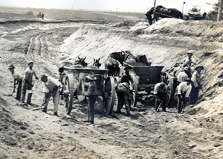
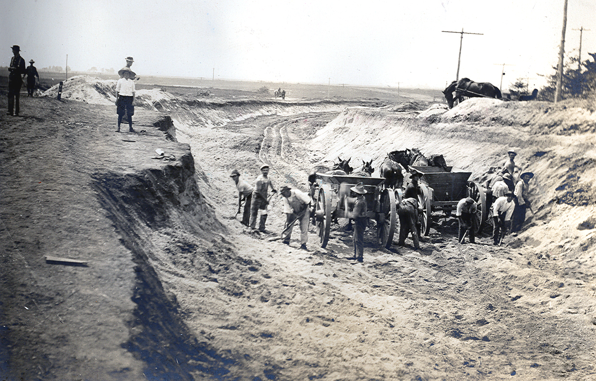
Mystery Foto #51 Solved :The Motor Parkway under construction in 1908 at Stewart Avenue in East Meadow

Did you solve this weekend's Mystery Foto?
Answers to the Mystery Foto questions:
- The location of the Mystery Foto and the orientation of the photographer
Looking west under on the Motor Parkway (now Salisbury Park Drive) at Stewart Avenue in East Meadow.
- What was being constructed at this location?
The Stewart Avenue Motor Parkway Bridge- a highway bridge since the bridge was over the Motor Parkway.
- Relate the Mystery Foto to the Vanderbilt Cup Races
Part of the course for the 1908, 1909 and 1910 Vanderbilt Cup Races.
Comments (8)
Congrats to Greg O., David Miller, Joe Osterle, Steve Lucas, Frank Femenias and Al Velocci for crrectly identifying the Mystery Foto East Meadow location.
Kudos to Greg O. and Frank Femenias for their jpeg documentation.
Enjoy,
Howard Kroplick
Close-Ups


Comments
Great rare shot!
Couldn’t quickly find it to confirm, but this should be looking west out over what will be Eisenhower Park from present day Salisbury Park Drive.
Ladenburg property on the right during the foreground construction of the Stewart Ave LIMP bridge for the 08, 09, & 10 Cup races. “Meadowbrook” bridge hasn’t been started yet in the background yet.
The bridge, and later 1938 aerials;
This is a picture of the Stewart avenue bridge under construction in East Meadow. The photographer is facing west. Workers were digging by hand below the grade area to allow the Motor Parkway to run under the soon to be constructed Stewart avenue bridge. The utility poles on the right and the curvature of the roadway are consistent with this location. As documented on 8/13/13 and updated on 2/18/16 by the Vanderbilt Cup races this location covered both the 1908 and 1909 races showing crowds and artistic representations.
Digging out for LIMP to cross under Stewart Ave, east side of Eisenhower Park. Looking back west. Sort of looks different there now.
I’m stumped. Not much to go on here with no distinctive buildings, just a hole in the ground. As there are existing power poles down one side of the unpaved roadway this is perhaps an underpass being constructed along some road, but in that case I would expect a bypass road to be to the left away from the trees. May better be a farm way bridge.
Turning all the cards over a Google image search only yielded this same web page.
Have to try two guesses - Today’s Levittown looking west from Newbridge Road or Merrick Avenue (East Meadow) looking east.
Either the Newbridge Road Bridge or the Meadowbrook Bridge.
Course of the 1908-1910 races.
I think this photo shows excavation work being done for the LIMP roadway to pass under the yet to be built Stewart Avenue bridge in East Meadow / Salisbury. It looks like the photographer was looking generally west. After construction was completed, this section of the LIMP was part of the course for the 1908, 1909, and 1910 Vanderbilt Cup Races.
Possibly the flat Hempstead Plains in Salisbury, Long Island. These workers were engaged in extensive manual labor. Hats off for their efforts and dedication in making the Motor Pkwy possible! (most of them surprisingly looked at the camera shoot!).
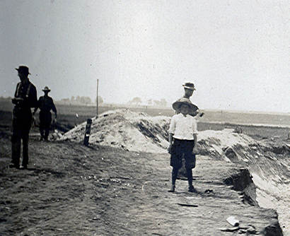
Based on the shadows, this photo is likely looking NW. I believe they are digging out the LIMP under Stewart Ave, where the Stewart Ave highway bridge will soon be constructed overhead, then re-connecting Stewart Ave RoW. Emily Ladenburg’s “Oasis” estate with windmill (unseen) is at the top right corner of the photo. Today’s Eisenhower Park is the stretch at the top left of the photo. The year is 1908 when Motor Pkwy construction began. This stretch of Motor Pkwy was used during the 1908-1910 Vanderbilt Cup Races on Long Island. The photo area is encircled in red below.
Happy Holidays to all!
Howard, The photographer is facing west. The laborers are excavating the last bit of soil for the Motor Parkway ROW under what will be the Stewart Ave. bridge, I believe this section of the Parkway- between this bridge and the Newbridge Ave. bridge- was where the most serious race related accidents occurred. Although the photo was taken in front of her estate, that is not Mrs. Ladenburg checking out the activity while tending to one of her horses at the top right side of the photo.
Another great rare photo Howard. Thank you for sharing Motor Pkwy history!
Ok Al, so that’s not Mrs. Ladenburg, but could you please identify the individual on the left side of the photo wearing the large brim hat staring directly at the camera? Also, his occupation and the name of his first girlfriend from High School?
These laborers are digging deep and long during the summer heat of June 1908. Not even the horses could help with this task, except to carry the dirt away from the pit. Horrendous work conditions pre excavators. I only hope they were paid appropriately for their efforts
Frank, The laborers at first were paid 10 cents per hour and worked a ten hour day Monday thru Friday and a half day on Saturday at straight time, (no overtime pay.) The Parkway provided sleeping accommodation in barracks like buildings that were built on skids so they could be towed to where construction was going on charging the laborers 50 cents per week. Most of them would go home for the short weekend taking the LIRR back to the City. See next comment
Frank, Your comment about the horses carrying the dirt away. Notice the direction the horses are facing. The excavated material is being brought to the Newbridge Ave bridge site and used to built the 300 foot long ramps taking the Parkway over that road. This part of the Parkway has always intrigued me because I have never been able to discover the reason for building the Parkway UNDER Stewart Ave. All the other Parkway road crossings east of Old Country Rd. are either at grade or over the roads. Is the Stewart Ave bridge truly a bridge? Its more like an underpass like the ones at Jericho Tpke. and Old Country Rd.
Greg O., The guy with the wide brim hat is actually the multi lingual foreman of the “gang” (as they were referred to). All the laborers were Italians or Italian Americans and for the most part spoke little and understood even less English. The engineers would tell the “Caposquadra” what they wanted and he relay the message in Italian to the gang. His salary was $1.10 per day. Regarding his first girl friend from high school, he never had one because he didn’t go to high school. After the sixth grade he sold newspapers or shined shoes on street corners. As he got older, he probably worked in a produce store and then, a little later got in to construction work. Regarding a girl friend, most likely never had one. His mother one day would casually mention a daughter of one of their paisian’s and one day marry one of them.
Thanks Al, amazing Motor Pkwy history info. 10 cents an hour in 1908 is equivalent to about $2.85 today. Besides provided housing, I’d bet the laborers were fed as well, as nearby diners didn’t exist back then.
Al, I agree the engineers planned the Stewart Av dirt for the ascent/descent ramps on the Newbridge Av bridge. Planning over and under bridges also best suited the short distance between them (0.15 miles), on reversing curves no less!
Photo below shows a similar scenario but less treacherous, of both Jerusalem Av parkway bridge and Massapequa Rd parkway bridge in Massapequa, just 0.2 miles apart. A real roller coaster ride.
Thank you Howard for posting this rare historic Motor Pkwy photo in Salisbury, LI
Frank, your thoughts on why the ‘parkway’ to ‘highway’ bridge combo here makes sense was my thought as well.
The Bellmore bridge was dangerous enough on its own, with Harold Stone nearly killing himself when his Columbia went off of it at the top in the 1910 races. Coming to 2 ascension peaks on turns that close together would have been true carnage.
Just east of here is Carmen Ave, which was also a highway bridge over the LIMP. Don’t know if there was the same amount excavating here as at Stewart Ave? To create slopes for Carmen Ave? We can see this as one site can become a ‘borrow pit’ for the immediate site or the next one ahead. They obviously worked very hard, but at the same time planned wisely.