Mystery Friday Foto #50 Solved; Fresh Meadows and the Motor Parkway in the Snow

Frank Femenias challenged you to identify this Fresh meadows snow-covered Motor Parkway location.
Identify;
- The location and orientation of the photographer
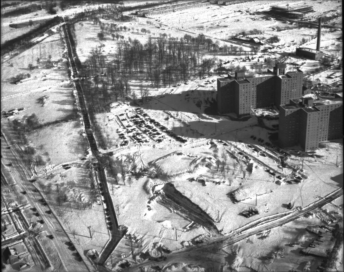
Fresh Meadows, Queens looking East South-East.
- The Motor Parkway and other roads
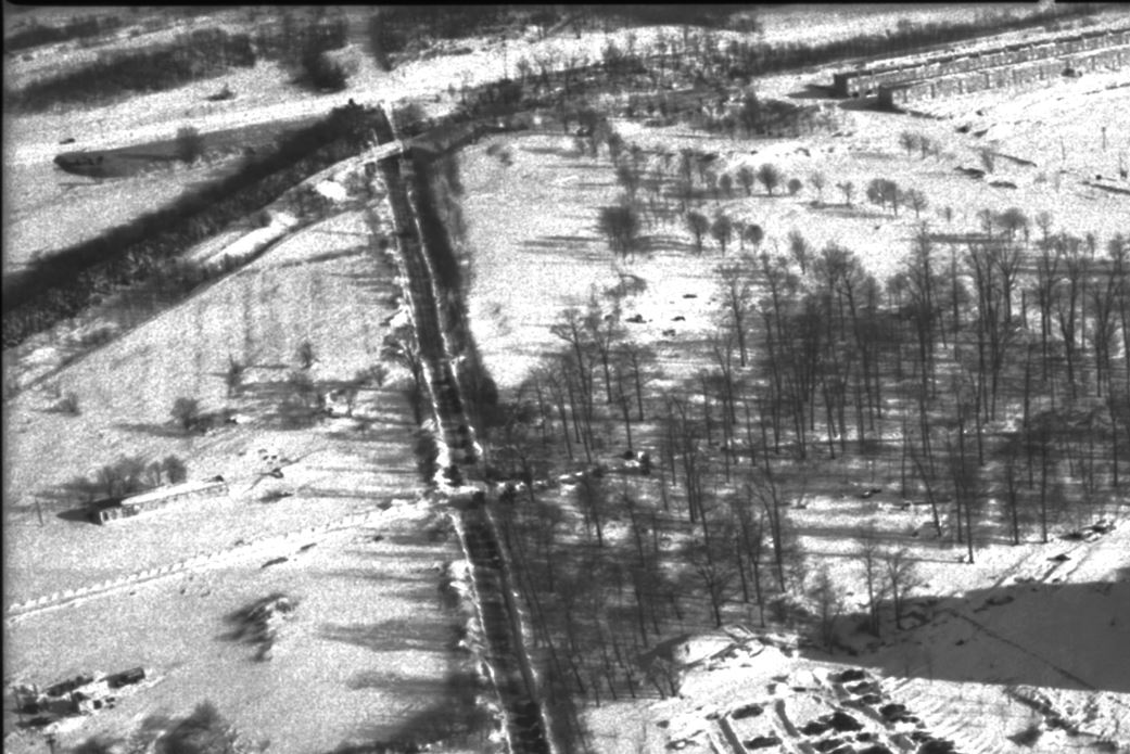
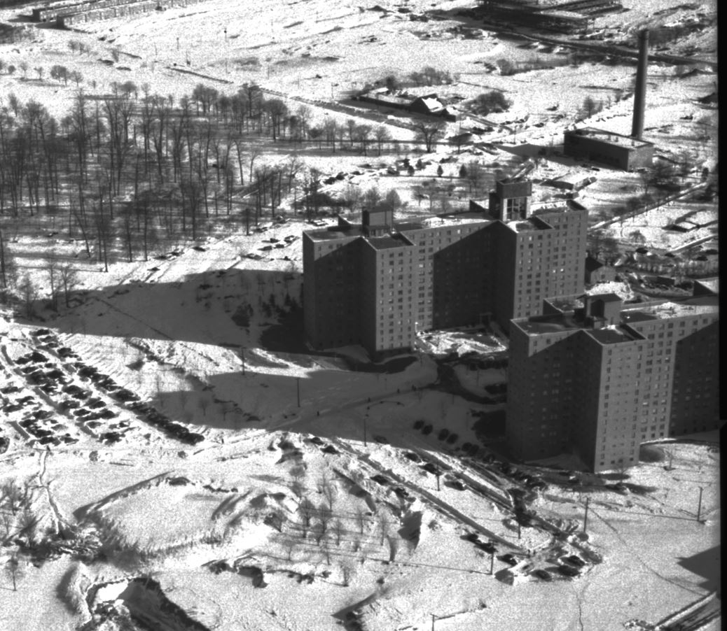
The Motor Parkway at the extreme upper left, Horace Harding Blvd., North Hempstead Turnpike. and Francis Lewis Blvd.
- Motor Parkway structures
The North Hempstead Turnpike Bridge
- Approximate date. Provide a rationale.
December 29, 1947
Congrats to Eric Shaffer, Mitchell (Mitch) Paluszek, Steve Lucas, George Philippides, Roy Warner, for identifying the location
Greg O.
Close ups


Comments
Bayside near Bell Blvd. Near Windsor Park in Oakland Gardens?
Easy-peasy. Fresh Meadows looking, essentially, eastward (southeastward?). Boulevard in the lower left corner is the pre-LIE Horace Harding Blvd. Piece of a road at upper left is Francis Lewis, near today’s St. Francis Prep. I’d date this as 1951??? Pre-LIE/Post-Fresh Meadows complex.
We are over the Fresh Meadows Housing Development in Queens looking mainly east or slightly south-east. The LIMP runs left to right near the upper left corner. Other roads include Horace Harding Blvd., North Hempstead Tpke., and a small piece of Francis Lewis Blvd. The only LIMP structure visible is the bridge over N. Hempstead Tpke. The old LIMP entrance is just out of frame to the left and the 73rd. Avenue bridge appears to be just out of frame to the right. Since the only housing development buildings that look complete are the high-rise structures on the right, I’ll date the photo around 1947-1948.
Fresh Meadows looking east.
Motor Parkway visible in upper left corner heading toward Western Terminus.
Horace Harding blvd on left with North Hempstead Turnpike bridge remnant visible.
Likely circa 1947-49 as the Fresh Meadows Apartment complex is up- built in 1946, but Holmes oval not apparent- have seen 1950 pictures with that present
Pilgrim Psychiatric Hospital looking South East. Road lower right of picture is Commack Rd. Road going lower left to upper left is Crooked Hill Road. Road farthest left is L.I.M.P. (Vanderbuilt Motor Parkway) Don’t know the date of the picture.
It sure looks like where I grew up—- Fresh Meadows. However, it’s during its early construction because: (1) there are no two-story garden apts in the view taken; (2) North Hempstead Tpke south of Horace Harding Blvd is there; (3) the angled Peck Avenue can be seen; and the north/south 188th St. can be seen. NY Life bought the old Fresh Meadows CC just after the War. Most of Fresh Meadows was completed in or about ‘1947-‘48 (the latter being the year I was born), if memory serves me correctly. I can make out the shopping center and its parking lot. Of note is that Fresh Meadows was the site for the first Bloomingdale’s “suburban” store. The gigantic snowfall of ‘47, which broke records, might have been when this photo was taken. “Choppers” were in their infancy; in my time in the Marines it was called a Huey (Helicopter Untility). So, maybe the picture was taken from a “helo,” from a “cub” aircraft, or from another type of low flying plane.
Tough one. I believe it is in the Fresh Meadows area which is much more built up today. On the lower left is Horace Harding Boulevard before the LIE tore through the area. The two larger buildings are still standing today and are on 188th street today. The view is looking east with the motor parkway in the extreme top of the photo where it met up with Horace Harding Boulevard. The first bridge from the start of the Motor Parkway is shown. Circa 1935 right before the Motor Parkway closed.
Motor Parkway is at upper left. Somewhere near Creedmore maybe. Close to Winchester blvd and right of way near Union turnpike expansion. Can’t get my bearings on this one. So far this is all I’ve got.
I found out that at the time this was the second worst snowfall in NYC since the storm of 1888. On Christmas Day 1947 it began snowing without heavy winds, that would accumulate to an average of 27in in 48 hours for the Metropolitan area. Some areas in The Bronx reached above 30in
Roy Warner:
Below is a Fresh Meadows aerial photograph looking NE towards 199St and 51Av. I can send the hi resolution photo by email. Reach me at .(JavaScript must be enabled to view this email address)
Click here to Download this file
I didn’t participate in this one, but do like Walter Blessings answer, though the guess wasn’t it. These buildings are similar in design of Pilgrims buildings. And at first glance, the road patterns are similar to those in Commack.