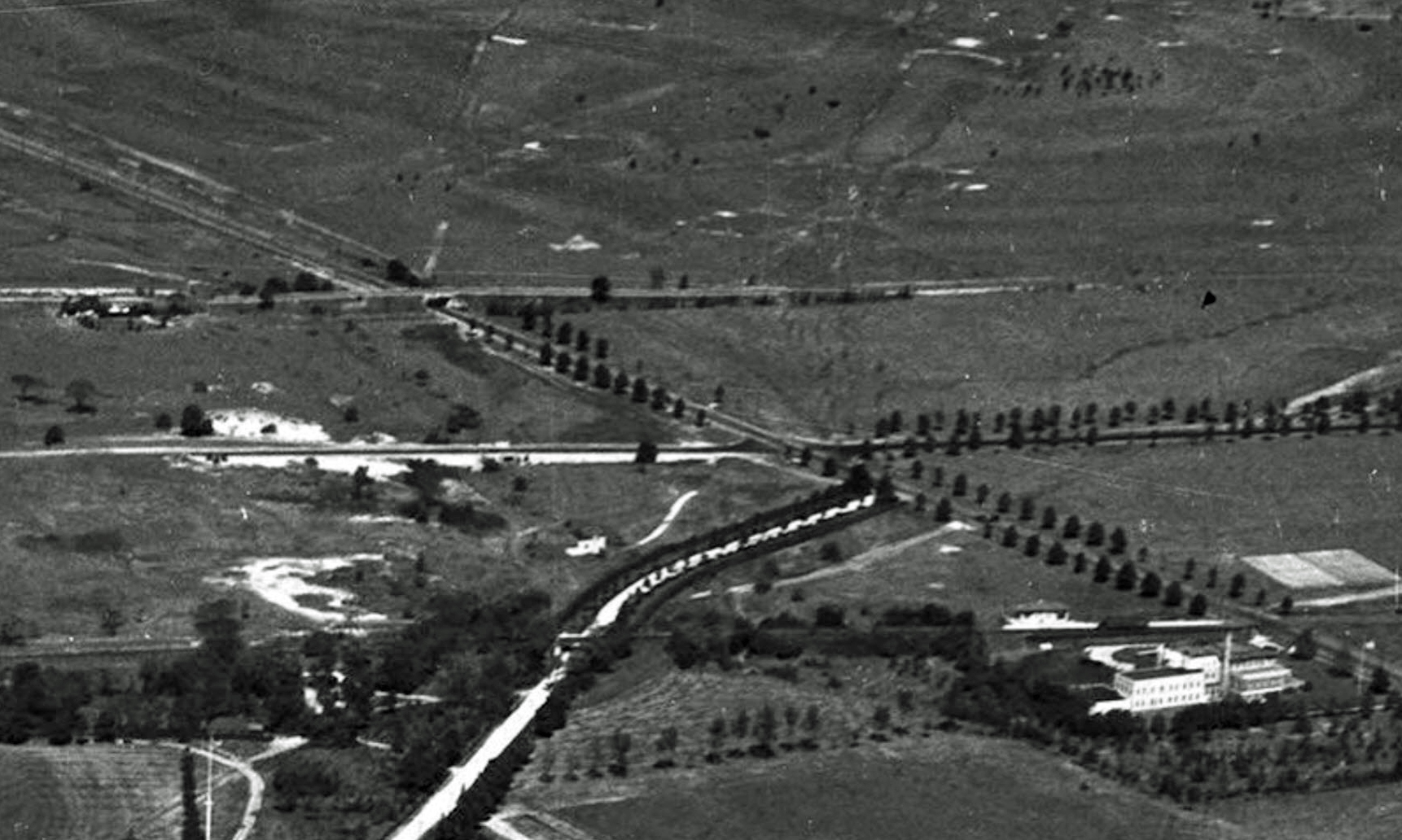
Mystery Friday Foto #5 Solved: A 1930’s view of the Motor Parkway area around Merrick Avenue in Westbury and East Meadow
Greg O. challenged you to solve this weekend's Mystery Foto?
Answers to the Mystery Foto questions:
Identify:
- The location and orientation of the photographer
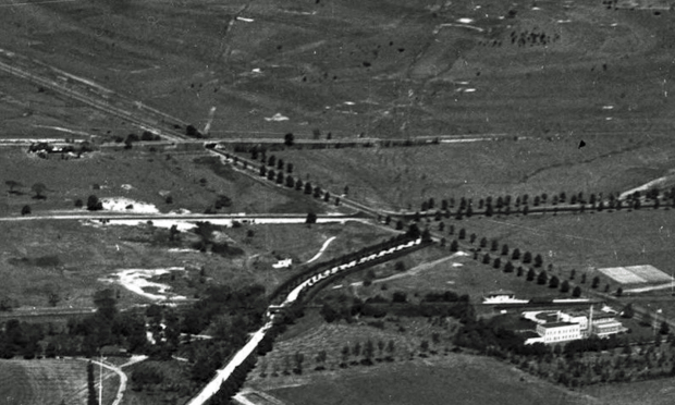
Looking north east over Westbury (now Uniondale) and East Meadow
- The major roads
Long Island Motor Parkway on top with the parallel Stewart Avenue to the south. Merrick Avenue is on the diagonal. The Meadow Brook Hunt Club Road was the large white road below Stewart Avenue.
- The golf course
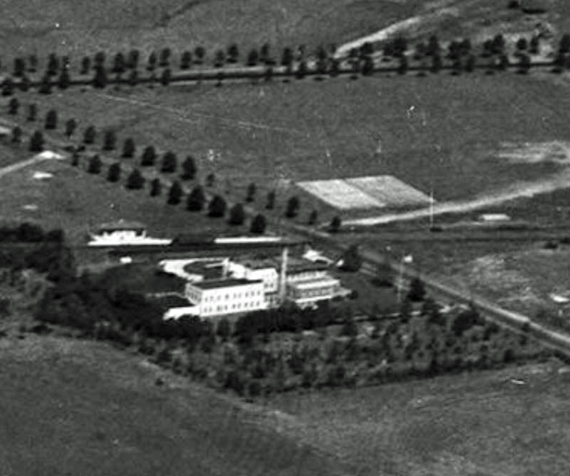
Salisbury Links (now Eisenhower Red Course.)
- Long Island Motor parkway structures
Meadow Brook Lodge and the Merrick Avenue Motor Parkway Bridge
- Structures related to railroads
The Salisbury Plains Central Railroad station and the bridge over the access road. The bridge is still standing!
- The building on the lower right
Salisbury Links clubhouse
- Date of the aerial
1932-1934 Original Source: SMU Libraries
Comments (7)
Congrats to Lee Chambers, Art Kleiner, Steve Lucas, John Cunningham and Frank Femenias for correctly identifying the Merrick Avenue location.
Kudos to the marvelous mapper Frank Femenias.
Enjoy,
Howard Kroplick
Long-Shot
The Mystery Foto was a cropped image of the 2018 Mystery Foto #1 from the SMU Collection.
Close-Ups


Comments
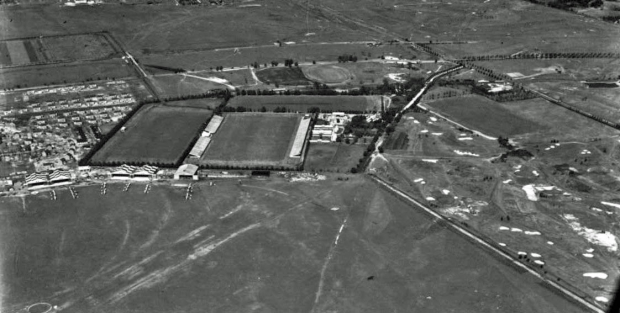
Northeastern most corner of what will become Mitchel Field. Curved, tree lined roadway is Meadow Brook Club Road which goes under the Central Railroad of LI trestle just before arriving at the Salisbury Plains station at Merrick Ave. The Salisbury Links Clubhouse is adjacent to the train station.
Parallel routes running West to East, left to right are from top to bottom, the LIMP, Stewart Avenue and the Central RR. Meadow Brook Toll Lodge can be seen just to the West of Merrick Avenue along with the bridge leading over it and on to the links at Salisbury.
Out of range and to the Southwest of the photo are the Polo Grounds which border Camp Mills and later, Mitchel.
Westbury, East Meadow - view looking northeast
LIMP, Merrick (Whaleneck) Ave., Stewart Ave., Newbridge Ave.
Salisbury Links
LIMP Merrick Ave. Bridge
CRRLI Train Trestle leading to the Meadowbrook Golf Clubhouse
Salisbury Links Clubhouse
1924
We’re over today’s Uniondale looking north east toward the Salisbury section of Westbury. Besides the LIMP, major roads include Stewart Avenue, Merrick Avenue, and the access road to the Meadow Brook Hunt Club. The golf course is the Salisbury Links. The LIMP structures are the Meadow Brook Lodge and the bridge over Merrick Avenue. Railroad structures include the Salisbury Plains station and the bridge over the hunt club access road, both on the Central Branch. On the lower right, we can see the Salisbury Links clubhouse. The date should be around 1932.
looking n/ne over the hempstead plains. motor parkway, stewart ave, merrick ave(whaleneck), meadowbrook hunt club access road and bridge. The meadowbrook lodge can be seen. present day eisenhower red course is the golf course. Central RR and meadowbrook station are visible and so is the bridge over the clubs access road. Photo taken around 1930. I got nothing on the building on the bottom.
Eisenhower red was called Salisbury golf club i think.
Great photo! About 1925 in Uniondale, flying over the Meadow Brook Hunt Club (future Mitchel Field) looking NNE.
Major roads from top to bottom; Motor Pkwy, Stewart Ave, CRR.
From left to right; Meadow Brook Hunt Club east access rd, Merrick Ave.
Meadow Brook golf course west of Merrick Ave.
Salisbury Links’ Red Golf Course covers most of the top photo east of Merrick Rd. (photo below).
Meadow Brook Lodge just west of Merrick Ave, and the Merrick Ave bridge.
The Salisbury Plains CRR station is seen. The CRR bridge still stands today abandoned by the Meadow Brook Pkwy. Easy access for explorers!
Lower right building is the Salisbury Links clubhouse west of Merrick Ave.
More CRR bridge
Top: Courtesy Dave Keller, 1955
Mid: Courtesy Dick Makse, 1964
Bottom: Courtesy Dick Makse, 1964
I grew up in Merrick, and this one stumped me! What threw me off was the Meadow Brook Hunt Club access road, which doesn’t exist today. Did this road connect with Westbury Blvd. to the southwest? I have never seen the CRR bridge, even though I’ve passed that way many times.
Al - The bridge is filled beneath and overgrown. One would have to park the car nearby and walk up to it. Once there, you can see frame of the bridge and walk on top a bit. White X on this map.
Al - the Meadow Brook Hunt Club east access road was just one half-mile in length and accessible only from Merrick Ave (map below)
Frank Regarding the three bridge photos you posted, I don’t think the third photo is the same bridge as the other two.
Al,
The 3rd photo is looking west across Meadowbrook Parkway towards the old LIRR Central Branch right of way behind the Nassau Academy of Medicine.
Al,
Confirmed. I’ve walked across the third bridge. On the other side of Meadowbrook Parkway was the terminus of the LIRR’s Central line after it was cut for Parkway construction in mid 1955 and which happened to be literally inside the dump once used by the USAF and later by NCC adjacent to Perimeter Road.
Meadowbrook Parkway construction - January 28, 1955, bisecting the former Meadow Brook Golf Club. Robert Moses gained access to the property through Eminent Domain. Construction was funded by the toll on the Southern State Parkway.
A large arc can be seen where the path of the roadway was being graded but concrete not yet laid down. The LIRR Central line had recently been cut to accommodate the roadway. Runways at Mitchel had not yet been extended.
You know, we keep referring it as the CRR bridge… but technically isn’t it an underpass ? The CRR was there before the Meadow Brook Hunt Club and they didn’t “bridge” the CRR, they went under it. While I’m at it…why didn’t the club have the entrance to the grounds south of the CRR ?
After checking with the 1906 Atlas of Nassau County I came up with why the Club didn’t have the entrance south of the CRR. Originally they didn’t have frontage on today’s Merrick Ave. south of the CRR. It appears the entrance from Merrick Ave. came later ( with the advent of the automobile ? ) as the Atlas shows two entrances from Stewart Av. straddling the first CRR station.
Al Prete, The Westbury Blvd. you referred to had no connection with the Meadow Brook Club. But , it does have an interesting history of it’s own and a connection to the Motor Parkway. Today the northern end is at Oak St. There was a time when it’s northern terminus was at Merrick Ave. just south of Old Country Rd. , Westbury. away from built up areas. At that time it was known as the Sheep’s Pen Rd. Sheep farmers from Hempstead and the surrounding areas kept their sheep at the northern end of the road. It was only when the Motor Parkway ROW was being built thru the Hempstead Plains that they were told that what looked like a dirt path was actually and legally a Town road ( since pre- revolutionary times) and would have to be bridged by the Parkway. For obvious reasons the bridge was never paved. When the federal government took over the property where Mitchel Field was located, it closed off the road at both the Parkway spur to Hempstead Tpke. and Stewart Ave. That part of the road north of Stewart Ave. fell into misuse, remember it was just a dirt path, and eventually gobbled up by developers of that area.
Al,
I have very distant memories of reading somewhere the extant bridge was not the original one; there had been another one very close to it just to the west of it which preceded it but by only a few years. If I’m not mistaken, the original purpose of (let’s call it West trestle #1) was to go over water, possibly related to nearby Meadow Brook Creek.
And of course you are correct. The Meadow Brook Club Road did indeed go UNDER the (let’s call it East trestle #2).
Could you please post the image from the 1906 atlas?
Al,
Having spent virtually my entire childhood and adolescence growing up on Mitchel Field, I have always had a particular interest in the Westbury Blvd. that you speak of.
Many times we would take the portion of what’s left of it through East Garden City as a short cut to get to Garden City proper and/or Hempstead.
As for the part of the roadway that cut across what became Camp Mills / Mitchel,
I have never found any remnant of it (at least South of Stewart Avenue).
Would you happen to have a map of that area East of Oak Street from back in time?
Thanks!
Al,
Found this 1923 map showing Westbury Road east of Oak Street continuing in a northeasterly direction and terminating at the LIMP Spur.
Also, this 1914 map showing Westbury Road further east of the LIMP Spur across the soon to be Camp Mills, crossing the Central railroad tracks, then Stewart Ave. and merging south of the LIMP with the northern extension (beyond Hempstead Turnpike) of California Ave. from Uniondale.
It then crossed the LIMP and made its way to a rendezvous with Merrick Ave. (Whaleneck Road) just south of Old Country Road.
Al,
Could this the 1906 atlas image you are referring to? It shows two access roads from Stewart Ave. down the to Salisbury Plains station, one on either side of it, but both to the west of Merrick Ave.
This May, 1958 map of the Central extension indicates in hand written notes the approximate location of where Uniondale Ave. (referred to as ‘ex Uniondale Rd.’) once extended past Hempstead Turnpike and crossed through the area that became Mitchel.
I believe the reference to ‘ex Westbury Rd.’ was actually the extension of California Ave. north of Hempstead Turnpike. It would not meet Westbury Road until after crossing Stewart Ave. but before they got to the LIMP, the merged route continuing northeastward to Merrick Ave. just south of Old Country Road.
Lee During WW 1 the Government leased the property which would become Mitchel Field, the lease had language that the lease would terminate at the end of the war. At the same time the government leased most of the Motor parkway spur south of Stewart Ave. paying $31.90 per month per acre under the same conditions. There came a time when the Government extended Mitchel Field to Oak St. In September 1939 the Parkway sold the 50 foot wide portion of the Hempstead Spur south of Stewart Ave. for $8900.
Just speculating but I always thought of the east access road as the service entrance for horses’ arrival to the Club, and the west access road as the main entrance from Stewart Ave.
Gary & Lee, My comment about the underpass… it appears from the two top photos of the bridges it wasn’t necessary to excavate under the CRR to construct the road from Merrick Ave. to the interior of polo grounds. The area around the underpass on both sides of the CRR is at the same level as the road surface. Also, it appears as if the CRR was built on fill thru that area, so in reality… the CRR ended up in “bridging” the polo grounds roadway.
Frank, The Meadow Brook Club didn’t have access from Stewart Ave. until they acquired property north of Stewart Ave. in late 1929/early 1930 and built the new polo fields. At the same time the Club acquired a strip of land from Stewart Ave. south ( part of which I think is today’s Endo Blvd.), to the CRR. This tract was used primarily by the polo ponies to and from the stable area and the new fields. Knowing the grade level of the CRR at that point, I’m guessing the Club built an underpass at the time ???
When I first stumbled upon the CRR trestle in 1971, I recall there being a fairly deep gully on the South side of it. My suspicion is that this may not have been a natural occurrence and resulted from the build up of grading for the Parkway. Last I saw the gully, it was full of leaves.
Lee, I don’t think the Parkway needed any fill from outside sources. Check Greg’s post of the McCamish family photos of April 18, 2020. The first photo is of the Lodge, the view is to the east. Note the grade level on the left ( north) side of the photo, it is much higher than the grade level of the ROW and the lodge. My gut tells me once the height of the bridge over Merrick Ave was determined, the Parkway wanted the Lodge at the same grade level as the bridge for several reasons. Can you imagine what the grade of the Parkway entrance from Merrick Ave. would have been if they didn’t lower the grade level of the lodge…. I’m guessing about 10 feet. I wonder how far back west and south the Parkway went lowering the grade.
Don’t know, except to say there were sources of water in the area adjacent to the trestle. Water tends to find the lowest point. As I recall, they had to make a minor adjustment of the route of Meadow Brook Creek to accommodate construction of the Parkway in that area.
Lee, based on the “1906 Atlas” map you posted above, the Meadow Brook creek RoW north of the two ponds shown, is indicated by a boundary line reaching the east side of the Club, likely requiring a bridge there for the CRR to pass over (the original “West Trestle #1”). Seems that manipulation of the creek occurred at some point to improve land use. This is also true for other points in Nassau, Queens, and the New York World’s Fair of ‘39
Lee, The entire area on the east side of the Meadow Brook creek between Stewart Ave. and Hempstead Tpke. for the longest time was subject to “ponding” from the overflow of the creek. An article in the Feb. 7, 1870 issue of the B.D.E. states “on the west bank the ground is some 15 feet above the bed of the creek” Regarding your mention of a previous bridge…. an article in the Apr. 23, 1903 mentions “a bridge that spans the creek” Did the CRR build it ? What happened to it ?
Interesting 1903 timeline. Presumably that bridge predates the extant trestle. Do we know when the existing bridge/over/underpass was constructed? I’ve never seen a cornerstone in any of the photos of it. What became of the earlier bridge, only Alexander Stewart knows for sure. And he’s not talking!
Lee, Some bits of trivia that might help. The Meadow Brook Club was established circa 1880, well before the advent of the automobile. So, I’m guessing the members for the first 20 years or so came out to the Club mostly on the CRR which was already there. Stewart Ave was built around 1905-1907, prior to that the earlier automobilists came out by Hempstead Tpke. and or Old Country Rd., no ? The big change at the club came in 1917 when they acquired the property on the east side on the club fronting on Merrick Ave. on which a new 18 hole golf course was built replacing the 9 hole course built in 1894. I got a hunch a lot of dirt, buildings, etc. was moved around at that time So far, unable to find anything on when the entrance roadway from Merrick Ave. was built or anything on bridges.
I am under the impression the Meadow Brook (Golf) Club offered pro-bono memberships to officers at Mitchel. Aside from being the right thing to do for our servicemen, there was no shortage of competition with other courses in the area, not the least of which were the Links at Salisbury, literally across the street on the other side of Merrick Ave. with four courses alone! The prestige of having high ranking officers on their rolls would have been motivation enough.
I happened to be passing the CRR bridge yesterday and it is still clearly visible from the Meadowbrook Parkway. When heading north, either on the main road, or the feeder lane starting just past 24 (closer), or entering the parkway north from Stewart Ave (closest) you can plainly see the bridge since the vegetation dies off in winter. Tried to get a pic but at 60 MPH you get one chance…
Frank, Are photos of bridges #2 & #3 taken by Dick Makse the same bridge ? On the right side of the photos note the difference in the top most embankment stones against the bridge. Also, in photo #3 the top of embankment wall is at the same height as the top of the bridge, doesn’t appear that way in photo #2.
Lee, The Meadow Brook Club didn’t offer membership to Mitchel Field officers during the war but did allow them to play for free. I think that came about because “Captain” Bobby Jones, the famed amateur golfer, reported to Mitchel Field for duty at the time. Enlisted personnel at Mitchel Field were also allowed at the club…but only if they volunteered as caddies.
Why would the pile of dirt blocking passage underneath the trestle in the 1955 photo have been removed by the 1964 photo? It wasn’t there in 1971 either.
Al - I believe photos of bridge 1,2, and 3 are of the same. I took that same photo of #3 about ten years ago. I am unable to locate it at this time.
Photo 1 is looking NE towards Stewart Ave/Merrick Ave.
Photo 2 is looking SW, opposite direction, towards the Hunt Club and Mitchel Field.
Photo 3 is looking W, towards Meadow Brook State Pkwy.
I will keep digging for that elusive photo
Frank, Yeah, I’m sure your right about the photos being of the same bridge. I was hoping that someone would come up with some info about the possibility of a bridge under the the tracks for the polo ponies going to and from the new polo fields north of Stewart Ave.
Lee, Regarding your Feb. 10 post about the 1903 timeline. In all likelihood there was a bridge of sorts prior to the one built for the Meadowbrook Club. In the same vicinity the CRR had to deal with crossing over what at the time was known as the Meadow Creek and the surrounding swampy area. I imagine it was a simple affair built just a few feet above.