Update: Mystery Foto #49 Solved: A 1947 Aerial of Levittown and William J. Levitt
Frank Femenias challenged you to solve this weekend's composite Mystery Foto.
Answers to the Mystery Foto questions:
Identify:
- The location and orientation of the photographer
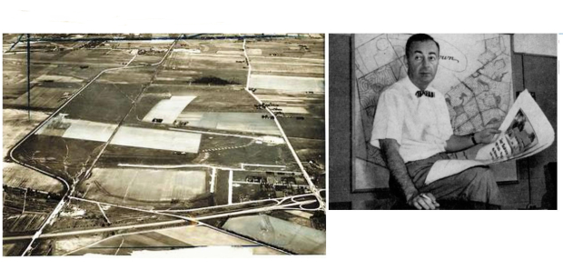
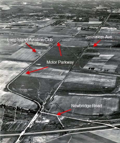
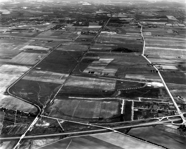
View looking east over East Meadow and Levittown. The Long Island Aviation Club, one of the first private country club airfields in the US, can be seen adjoining the Motor Parkway.
- The date of the Mystery Foto. Provide a rationale.
May 27, 1947
just prior to the construction of Levitt homes.
- Links to the Long Island Motor Parkway (the largest # of links wins the kudos)
See below Comments
- Links to the Vanderbilt Cup Races
The Motor Parkway section in this Mystery Foto was part of the courses for the 1908, 1909 and 1910 races.
- The businessman and his link to the aerial
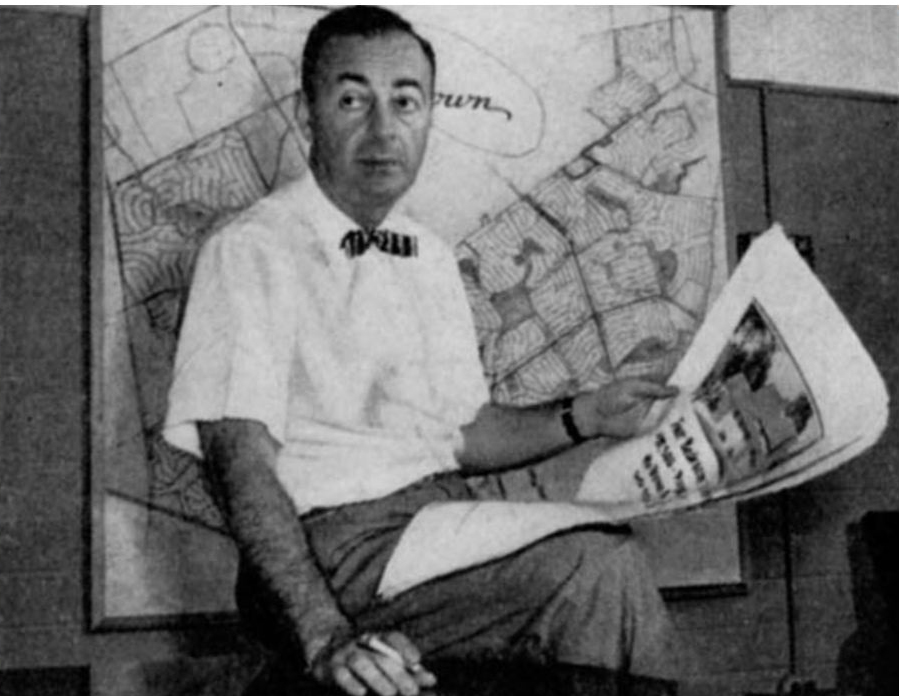
William Jaird Levitt, president of Levitt & Sons in 1947.
Comments (11)
Congrats to Joe Oesterle, Al Prete, David Miller, Wayne Woodbury, Ernie, Greg O. Steve Lucas and Al Velocci for identifying Levittown.
Kudos to Al Prete, David Miller, Greg O. Steve Lucas and Art Kleiner for their multiple links to the Motor Parkway.
Congrats to
Enjoy,
Howard Kroplick
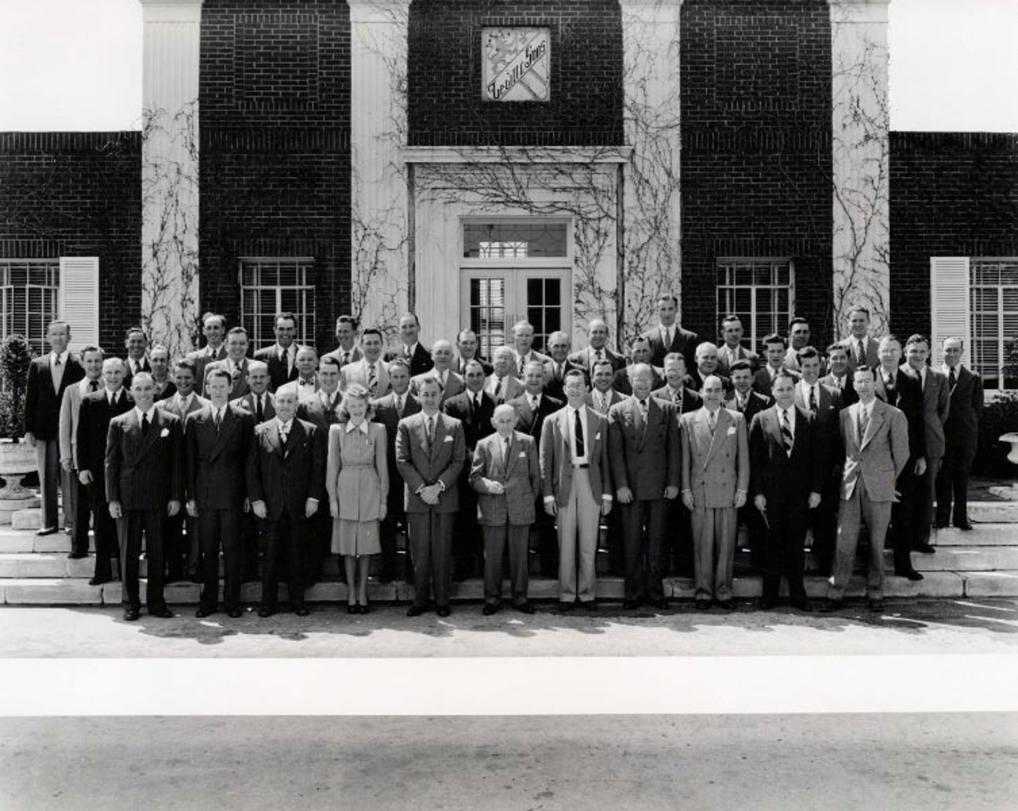
As seen in this 1947 photo, Levitt & Sons had their headquarters on Northern Boulevard in Manhasset. Abraham Levitt (1880-1962), the company’s founder, was seen here with his staff of 49 including the “Sons” William (left) and Alfred Levitt (right).
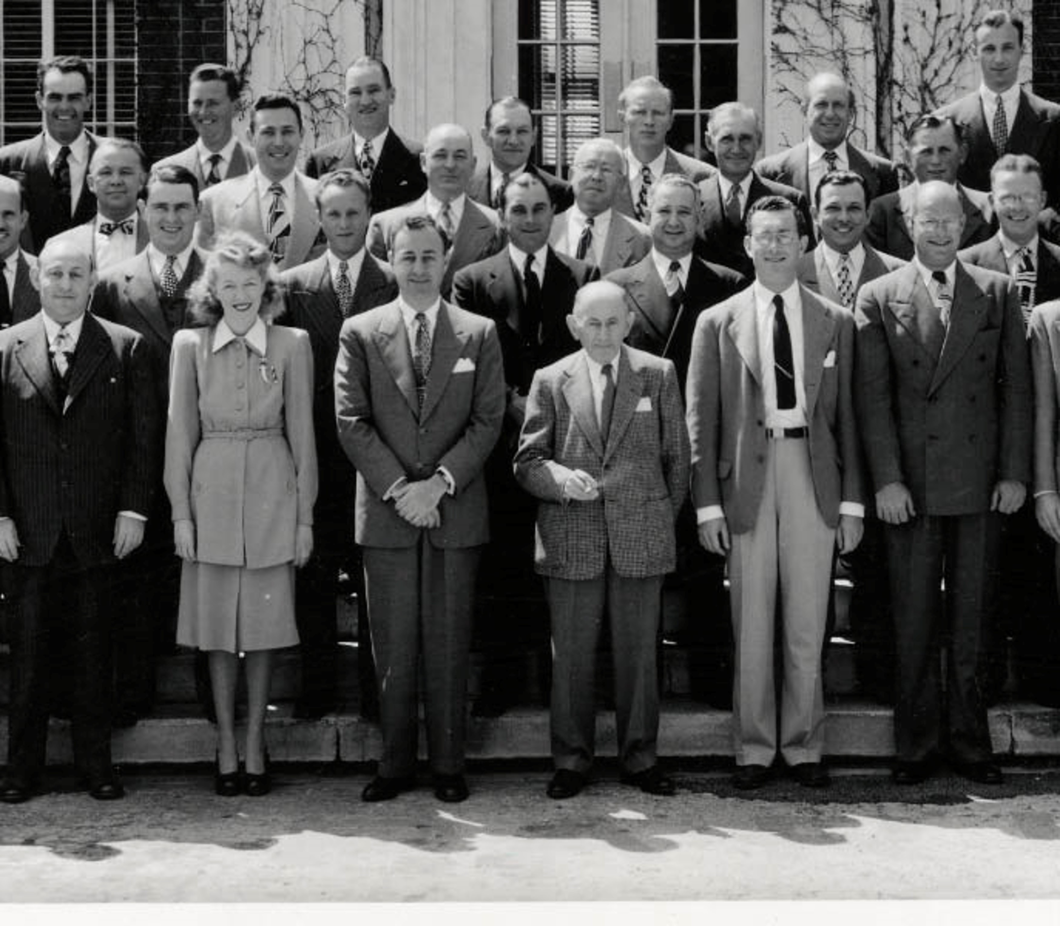
The only woman in the photo was William Levitt's secretary Alice Kenny, who later became his second wife. From North Hempstead by Howard Kroplick
Close-ups


Comments
Levittown, looking East. After 1933, since I can see Wantagh pkwy bridge. Before 1939, since LIMP looks open, as bridges are all up. LIMP bridges, ROW, grandstand location all appear.
The Foto is of the land on which Levittown would be built. The community was then called Island Trees. The photographer is looking east. It must have been taken around 1947, when the construction of Levittown was approved. The Wantagh Parkway, Old Westbury Road, and Newbridge Road can be seen at the bottom of the Foto. The Motor Parkway and Central Railroad are on the left, and Hempstead Turnpike is on the right.
It’s hard to see, but it looks like the grandstand for the Vanderbilt Cup Races on the north side of the Motor Parkway.
The businessman is William J. Levitt, who would transform the land seen in the aerial into America’s first suburb.
Pictured is William Jaird Levitt who was the founder of the Levittown development
for returning veterans to have housing for them and their new families..
Such a great photo of the Hempstead plains just before the building of houses by Levitt & Sons. This picture was was taken May 27, 1947 and this is a view looking east. Newbridge rd and Wantagh parkway are in the foreground, and the Motor parkway is on the left side of the photo fading into the distance. Also, the island of trees are still visible top center. This photo is linked to the Vanderbilt Cup Races from April 19, 2012 posting. The businessman shown is o William Levitt who posed for this picture as he is holding an advertisement for Levittown, posted in the Saturday Evening Post, August 1954.
I am unable to locate the grid map behind the Long Island business man’s right shoulder. None of it seems to exist today, not even partial. The map behind may have been a proposed map during early development strategies.
This is one of the classic photos of the area that would become Levittown. The photographer is over the East Meadow area looking east. The Motor Parkway crosses Wantagh Parkway from the bottom and continues east with the bend north and then back south before continuing east. The Vanderbilt Cup Races grandstand would have been just below the dark line that appears on the photo. That’s the Green Acre Homes development (1933) in the lower right adjacent to the WP/Hempstead Turnpike cloverleaf. The appearance of a completed Wantagh Parkway (1936) and the lack of any Levitt development would place this picture at between 1936 and 1947. I am going to guess 1946-1947 since it may be related to an aerial survey of the area for Levitt. Oh yes, the man in the picture is none other than William Levitt.
Of course we are looking at the classic photo of the beginning of the construction of Levittown New York.
We are looking east with the Wantagh Parkway and Newbridge Roads crisscrossing at the bottom, Hempstead Turnpike running up the right hand side, and the Motor Parkway snaking up the left hand side.
There are the pre-Levittown houses along Loring Road that ends on Sherwood road, possibly still under construction along with Wolcott, Birch, William, and James. Along what will be Schoolhouse the slabs for several homes can be seen. I can’t be sure if they end at Valley Road or Division Ave, which parallel there.
This section of Levittown was the first of several built. It was built only on the south side of the Motor Parkway, with a gap between the ROW and Orchid Road. Orchid ended at the curve south of the parkway, where homes were built on the ROW for the west side of Carnation. Homes were built in this gap later, as was the extension of Orchid to Newbridge.
Per Wikipedia, Levittown ground breaking was on July 1, 1947. As only the slabs of several houses are complete this must be shortly after that date.
The man pictures is none other than William Levitt who pioneered the entire plan for this town and several others. Wikipedia dates the photo as 1964.
Aside: I am writing this from my family home located in the dark area left side where the parkway curves south the Newbridge.
-The location and orientation of the photographer
Looking directly East at the Island Trees section of the Hempstead Plains.
-The date of the Mystery Foto. Provide a rationale.
A very freshly built Wantagh Pkwy. May 27th, 1947.
-Links to the Long Island Motor Parkway (the largest # of links wins the kudos)
LIMP vertical on the left. Seen in the photo; Long Island Aviation Country Club, Newbridge Rd, Jerusalem, Bloomingdale Rd bridges, dead man’s curve also all seen.
-Links to the Vanderbilt Cup Races
1908, 09, 10 races all held on this portion of the LIMP.
-The businessman and his link to the aerial
William Levitt seen and the aerial is the future site of Levittown.
The same area was unrecognizable just 2 1/2 years later on Dec 24th, 1949
We are looking east with Island Trees (soon to be Levittown) in the foreground and Bethpage in the distance. The date is mid to late May, 1947 since no significant Levitt home construction is visible. LIMP links are the bridges at Wantagh State Parkway, Newbridge Road, Jerusalem Avenue, farmway bridge near Bloomingdale Road, and 3 others in the distance at Wantagh Avenue, Massapequa-Hicksville Road, and Jerusalem Road. Vanderbilt Cup links are: the section of the LIMP on the left was part of the course for the 1908, 1909, and 1910 races. Hempstead Turnpike on the right was part of the 1904 V.C.R. course. The businessman is William Levitt, who along with his brother Alfred, continued their father Abraham’s business in building the Levittown that we know today which began in the central area of today’s photo.
My old stomping ground: Levittown/Island Trees looking east, north of Hempstead Turnpike over the LI Motot Parkway.
Early-mid 1940s (before Levitt homes were built)
Motor Parkway Bridges: over Wantagh Parkway, Newbridge Road, Jerusalem Ave., Bloomingdate Road, Wantagh Ave., Mass.-Hicksville Road
VCR - course of the 1908, ‘09, and ‘10 VCR races. Grandstand Location, access roads for parking.
William Levitt - built Levittown around the Motor Parkway.
Frank, The gentleman is Wiliam Levitt. The photo is from the early-mid 1940’s of soon to be Levittown, Long Island. The sub-division map behind Levitt is of Levittown, Pa. He is smoking… ( I can barely make it out ), an unfiltered….......... wait , I got it !. a Camel cig.
Part of the Motor Parkway shown in the photo as it looks today. Between Heron and Skimmer Lanes in Levittown. A future Kleiner’s Korner will detail numerous land transfers between Nassau County and other entities in Levittown and other locations where the Motor Parkway once stood.
Glad to hear that Art is doing a future Kleiner’s Korner about land transfers between Nassau county and other entities in Levittown about the Motor Parkway. I always wondered why Levitt didn’t claim the ROW between Pintail lane and Jerusalem ave. And why the construction of Levitt homes along the north side of Orchid rd were curiously delayed? Although nearby, I would think that the Long Island Aviation Club holdout property was a completely separate issue for Levitt and should have nothing to do with this.
Yes, but who can name the town that Levitt used as his prototype?
Mark, was its Levitt’s earlier contract to build homes in Norfolk , Virginia?
I think Levitt built homes in Carle Place prior to building Levittown. Cape Cod style homes. I grew up on Crabtree Lane in this first section and my parents were one of the first 300 families to move in. I’m curious to know when the LIMP bridge at Newbridge Road was demolished. I cant see it in the photo. I’m guessing 1946.
Norfolk was the prototype to the 4 communities Levitt built called “Levittown”. Long Island, Pennsylvania, New Jersey, and Puerto Rico all have a Levittown with New York being the first.
The long stretch of LIMP between today’s Pintail and Solar Lanes that Levitt left alone became a drainage problem for the new homes. From what I’ve learned here, this stretch was filled in & leveled out. Also several basins have been dugout along this stretch.
Michael- The Newbridge Rd bridge came down in 1947. A little tough to see, but zooming in on an aerial from that time shows the bridge being removed.
I have added a 1947 photo of the Levitt & Sons staff in front of their Manhasset headquarters. Does anyone know where the building was located?
I believe Levitt’s Manhasset headquarters were located in what became the Sperry building on Marcus Ave (actually New Hyde Park). It was also the first home of the UN and is currently Northwell Health’s CFAM facility. I recall seeing a photo of the Levitt offices many years ago and just happened to go to the area in 2001 for a Northwell (then NSLIJ) event. The 1950’s interior design was still there and was quite striking. Of course, I may be wrong.
Doing some research on vintage Christmas Cards I stumbled upon this one. How many greeting cards have your favorite car on them? Long live the Tucker.
I found a 1959 Manhasset Mail article that shows the Levitt Building as 1616 Northern Blvd. So I screenshot a building numbered 1615 Northern Blvd Manhasset. N/S of the road, then just opposite on the S/S of the road. Just W/O Deepdale Dr. This may have been his office building location, on the N/S.
Based on a zoning lawsuit, it appears that Levitt & Sons utilized a building it built in 1936 as a “Community Club” in its “Strathmore at Manhasset” development. The address in question is 1616 Northern Blvd., Manhasset and was on the south side of the street. Today there is no such address and the area is residential, what else - lol. 1615 is across the street and was built in approx. 1966. Will continue to search for additional documentation.
Brian - great minds think alike! I was searching for additional information while you were posting your’s first.
Art, the Levitt building referred to in your Comment is a different building than the Levitt headquarters building seen with the staff. As shown in these 1935 Library of Congress photos, Levitt used the Horatio Onderdonk Building for their Strathmore project in Manhasset. After all the residences were sold, it was given to the civic association which still owns it today on Onderdonk Avenue. The building is a landmark of the Town of North Hempstead.
https://www.loc.gov/resource/hhh.ny0337.photos/?sp=4
Howard - thanks for the correction. The Onderdonk building was given to the Strathmore Association in 1936, the same year the building at 1616 Northern Blvd. was starting to be used by Levitt. Attached articles are from “The Manhasset Press” of Nov., Dec. 1936 and July, 1938.
Other articles I’ve read discuss future Levittown homeowners getting in line at Levitt offices - perhaps the 1616 building is the one referenced in those articles.
No problem Art, always glad to look for answers if motivated. Great find with the location & background of the 1616 Levitt Building. Below is a present day aerial, 1950 aerial ( couldn’t find a 1938 aerial on the Stony Brook Collection ), and a 1947 Hagstrom. Maybe Levitts Building is one of the few just immediately west of Deepdale Dr, on the 1950 aerial. On the Hagstrom, I marked X on Levitt & Sons properties ( 3 seen ). One of them are near Deepdale Dr. 1615 Northern Blvd used to be Lustgarten.
Howard, With so much on Levitt this week, surprised no one mentioned their Vanderbilt connection. In 1937 Levitt purchased “Fairmont” at Manhasset which was the country estate of Virginia Graham Vanderbilt from 1927 to her death in 1935. Levitt named the project, Strathmore Vanderbilt at Manhasset. Her mansion was not destroyed but later on became the Strathmore Vanderbilt Country Club, still there.
This image is of a corner of Levittown when I grew up and still live.
Levitt built up to the south side of Orchid in Phase 1 with Cape Cod houses. Orchid Rd only went down to Carnation Rd where it curved to meet. Orchid was extended west in Phase 2 which left a bit of a kink in the road. The homes on the north side of Orchid are all ranch style
The houses on the west side of Carnation went down on the LIMP ROW. Somewhere I read a post from someone who grew up there who said the bank of the LIMP curve was in his back yard. I note the “park” but it is just a piece of land without even a bench to sit. I don’t know why this was left undeveloped like that. No pavement is visible there today.
When I was young we used to walk the abandoned ROW to get to the sump. Roadway was plainly visible until the houses were built on it.
The Pintail School (now torn down but for the parking lot and building slab and surrounding fence) was built on the ROW. I always found it curious the ROW curved a bit south before Pintail Lane and the fence around the property curved to match the border. The fence is still there and to this day you can see this. Just an obscure fact I don’t want to die with me.