Mystery Foto #46 Solved: A 1956 Aerial of the Meadowbrook Parkway and Roosevelt Field Shopping Mall Under Construction
Joel Friedman, volunteer archivist at the Cradle of Aviation, challenged you to identify this weekend's Mystery Foto from the Drennan Collection.
Answers to Mystery Foto questions:
- Identify the following:
- The location and orientation of the photographer
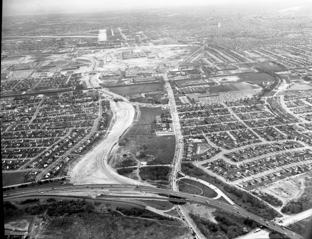
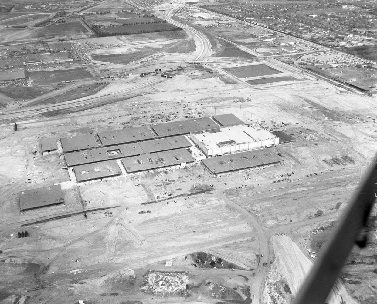
View looking south over the intersection of Northern State Parkway, Glen Cove Road and the construction of the Meadowbrook Parkway in Carle Place.
- Areas related to
- Aviation
-Mitchel Field in the background (still operating at the time of the Mystery Foto)
-Roosevelt Field- Three hangars can bee seen on Old Country Road just east of the Meadowbrook Parkway construction.
- Shopping centers
-Roosevelt Field Shopping Mall under construction. Yes, the mall provided outside shopping before being enclosed.
-E.J. Korvette (Korvettes) located on Glen Cove Road in Carle Place.
- The year of the Mystery Foto. Provide a rationale.
The Mystery Foto was not dated so 1955-1956 would be accurate considering the parkway and shopping center construction. Most likely date is May 1956, based on the below additional images from the Drennan Collection at the Cradle of Aviation.
- Link the Mystery Foto to the Long Island Motor Parkway
The tree-lined right-of-way for the Motor Parkway can be seen to the right. The Ring Road section of the Motor Parkway is in the southern section of the Roosevelt Field Shopping Mall.
Comments (14)
Congrats to James Dale, Mitch Kaften, Joe Oesterle, Al Prete, Ernie, Greg O., Steve Lucas, Lee Chambers, Mark Lanese, Brian McCarthy, Art Kleiner, Frank Femenias and Max Schnettler for correctly identifying the correct intersection location.
Kudos to Al Prete, Ernie, Steve Lucas, Lee Chambers, Mark Lanese, Brian McCarthy, Art Kleiner and Frank Femenias for recognizing the Motor Parkway right-of-way.
Enjoy,
Howard Kroplick
Close-Ups
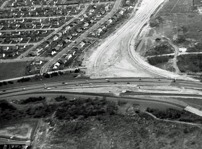
The future intesection of Northern State Parkway and Meadowbrook Parkway.
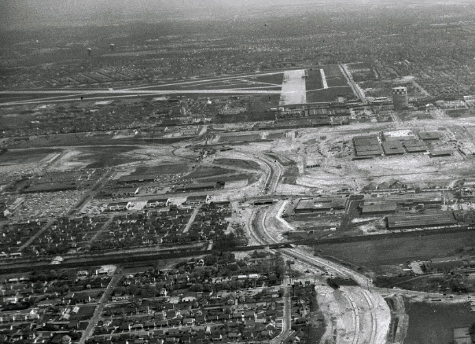
Mitchel Field surrounded by hundreds of homes was still operating in 1956.
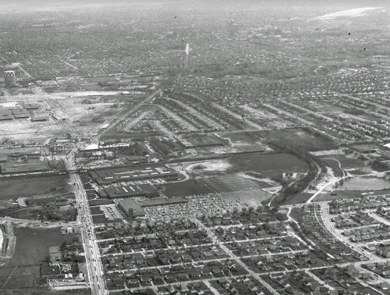
The tree-lined right-of-way for the Motor Parkway can be seen to the right. Korvettes Department Store on Glen Cove Road was busy that day.
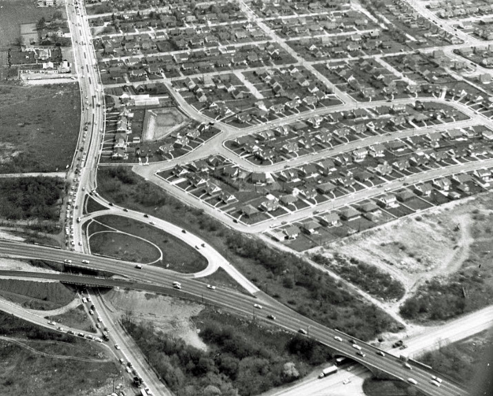
The Northern State Parkway Bridge over Glen Cove Road.
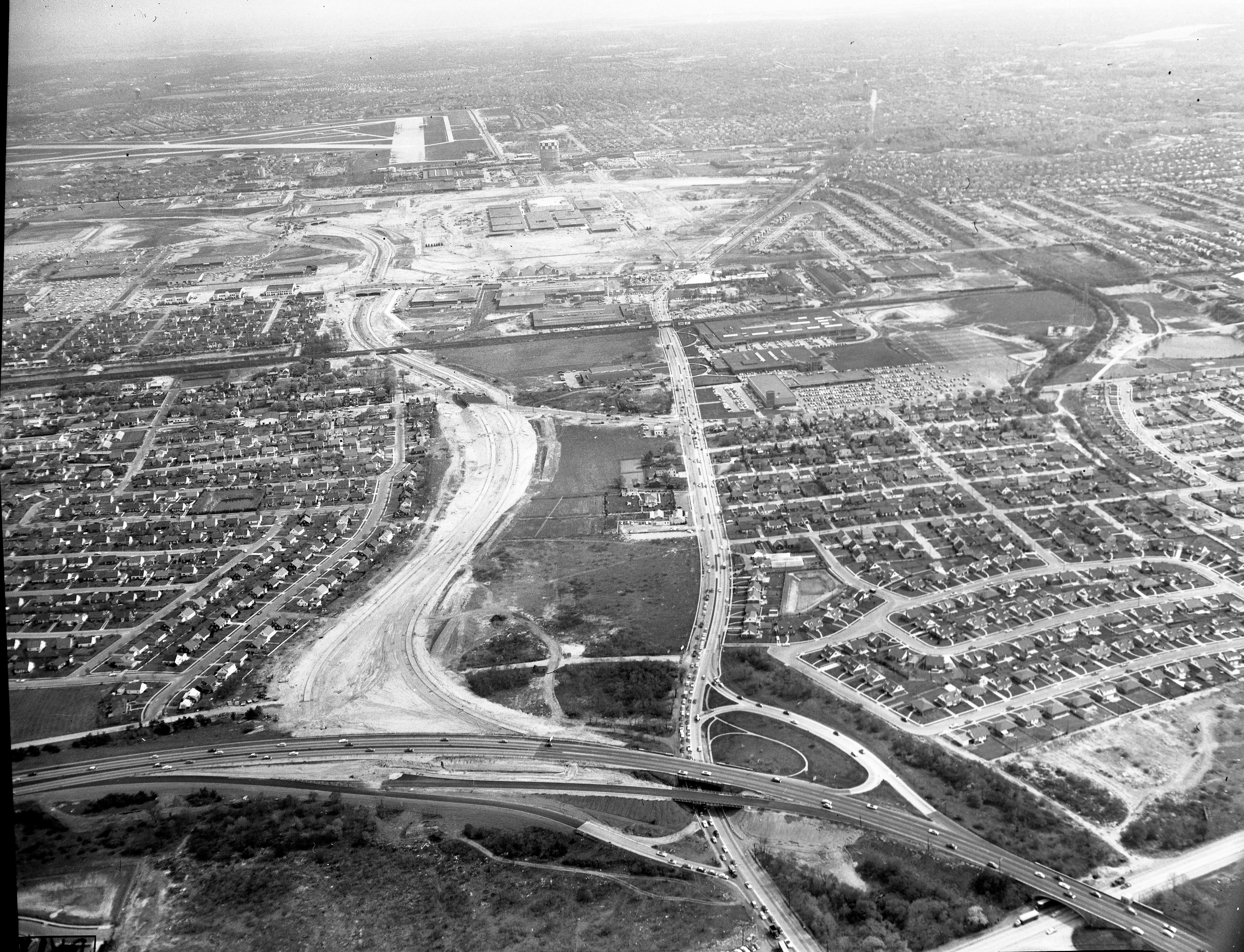
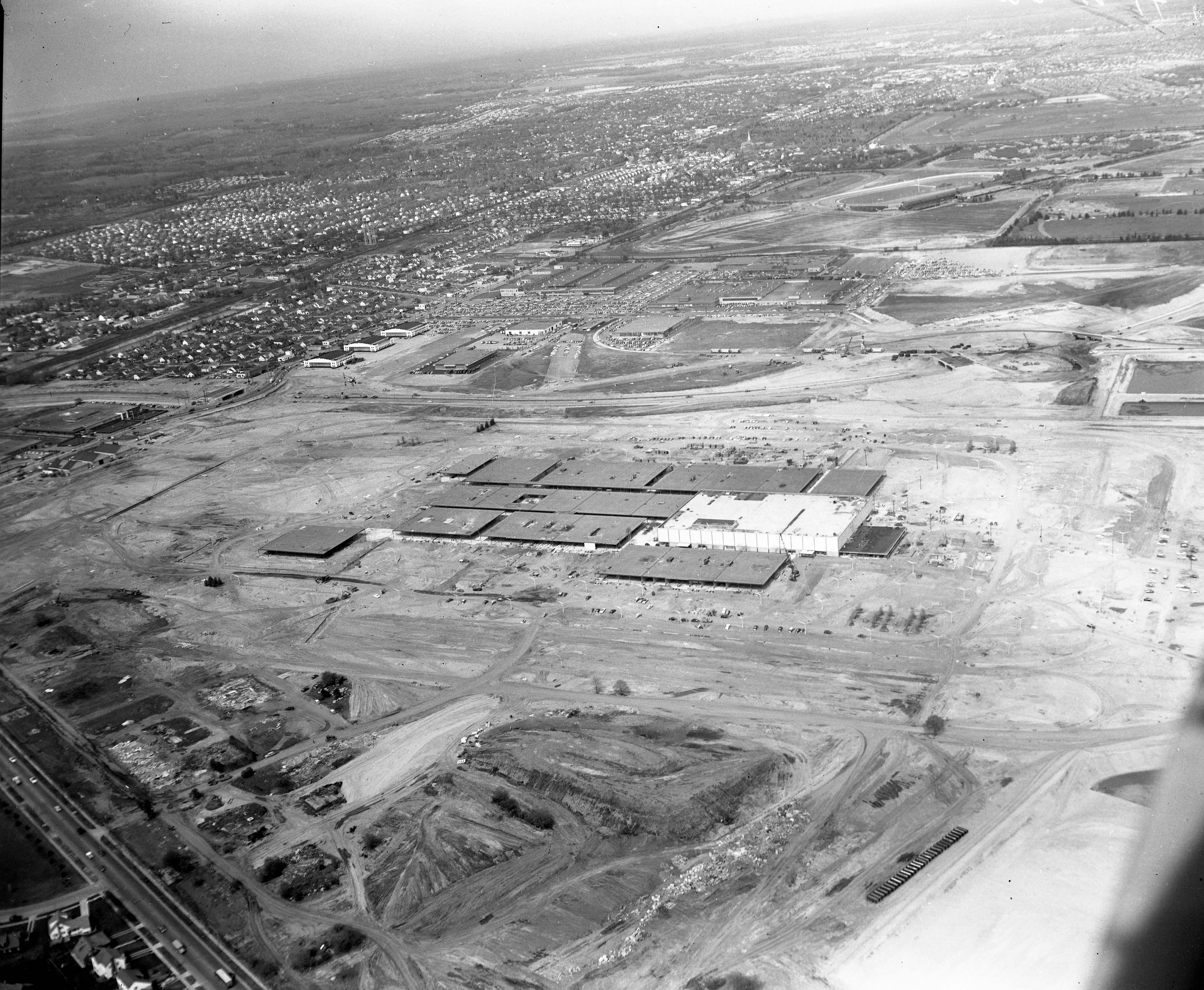
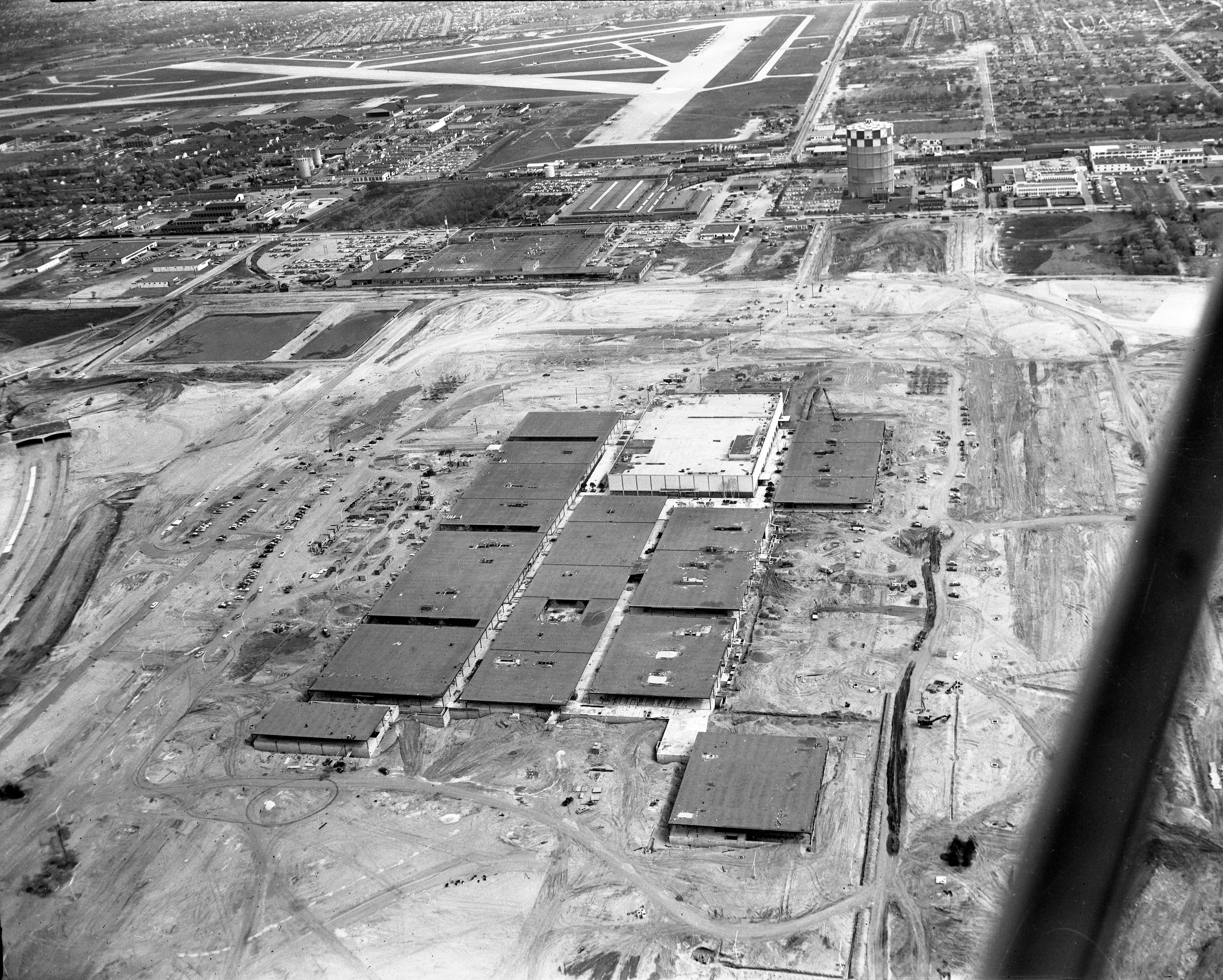
May 1956 Aerials of Roosevelt Field from the Cradle of Aviation
View looking northeast.
View looking south.
View looking east.
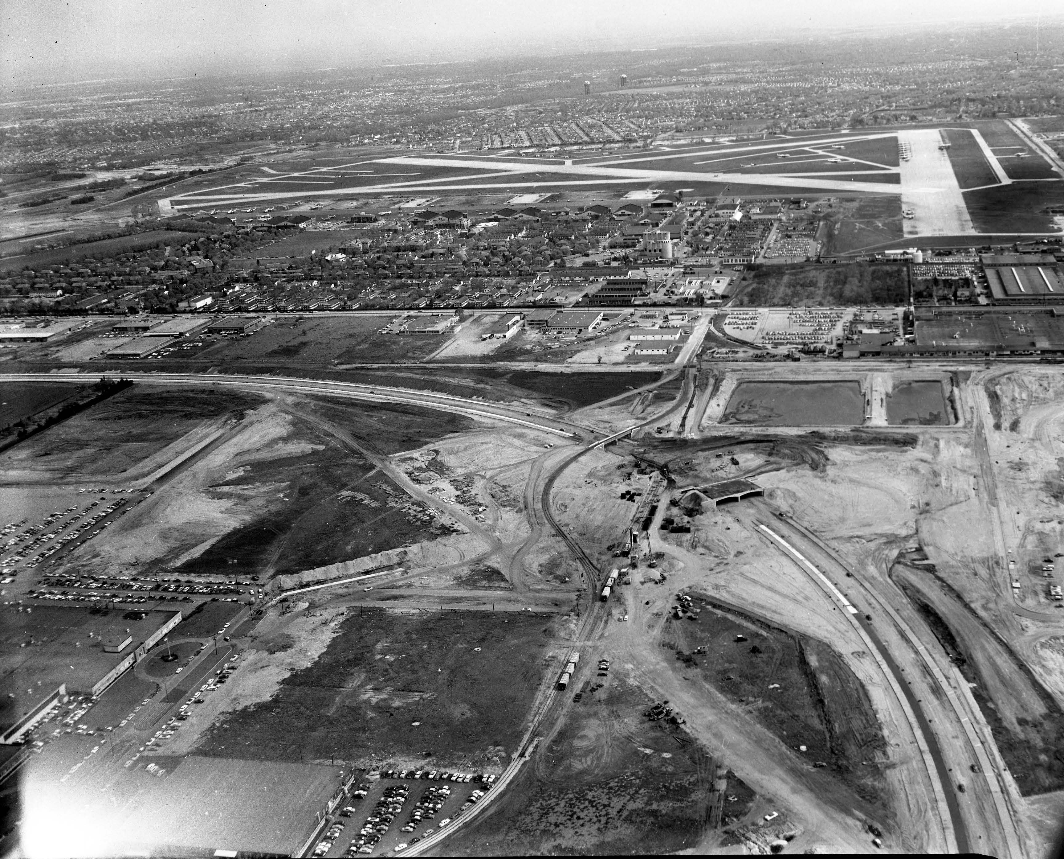
View looking east.


Comments
Northern State Parkway, looking South at the Meadowbrook Parkway being constructed, with Mitchell Field in the background.
A pure guess: this is viewing south at the construction of the Meadowbrook Parkway. Northern State Parkway horizontally at the bottom. Roosevelt Field was being converted into a mall at this time, which means it’s well after the LIMP was closed down. Mitchel Field runways in the background at the top. Glen Cove Road north to south, west of the Meadowbrook. I’m sure other commenters will do better.
Looking south. The unfinished Meadowbrook is coming alive as an exit off the Northern State Pkwy. You can see a peak of Jericho Tpke, Roosevelt Field, Carle Place streets, and even the LIMP too.
The location is the Carle Place/Roosevelt Field area, with the photographer looking south. Northern State Pkwy. in the foreground. Jericho Turnpike on the lower right. The vertical road in the middle of the Foto is Glen Cove Road/Clinton Road. To the left of Glen Cove Road is the Meadowbrook Pkwy. (under construction). Horizontally in the middle of the Foto is the main line of the LIRR. Above that, Old Country Road, and above that, Roosevelt Field shopping center (under construction), and beyond that, Mitchel Field.
I’m dating the Foto at 1955, because both the Meadowbrook Pkwy. extension north of the Southern State Pkwy. and the Roosevelt Field shopping center were under construction at the time. Also, Mitchel Field was still in use until 1961.
The remnants of the Motor Parkway can be seen as a dark curved line on the right of the Foto. It continues up, then curves to the left as it crosses Clinton Road and goes between Roosevelt Field and Mitchel Field.
The photographer is looking south, high above the interchange from Northern State Parkway to the under construction Meadowbrook extension.
The major roads are NSP and MBP, Glen Cove / Clinton Road is prominent going away from the photographer. The LIRR main line and Old Country Road cross left to right.
Areas related to aviation are Roosevelt Field after it’s conversion from air to a shopping mall. Mitchel Field is there top left.
The year of the foto is shortly before ‘56, as the MSP extension was completed in that year.
The ROW of the LIMP, marked by the line of trees, snakes along the right edge till it curves left over Clinton Road and merges with the Mall ring road.
-The location and orientation of the photographer
-The major roads and construction sites
Looking South at the construction of the Meadowbrook Parkway. In the foreground is the interchange for the Northern State to the Meadowbrook.
-Areas related to aviation
Michell Field in the distance
-Shopping centers
Roosevelt Field Mall
-The year of the Mystery Foto. Provide a rationale.
Parkway construction started in December 1953. Roosevelt Field Mall groundbreaking was in April 1955. The Parkway opened in October 1956. Both construction projects look well underway. My guess on the year is late 1955.
The photographer is looking south over Carle Place and Mineola towards Garden City. Major roads are Northern State Parkway, Glen Cove Road, Westbury Avenue, Old Country Road and Stewart Avenue (near the striped tank). Construction sites are the Meadowbrook Parkway extension and Roosevelt Field Shopping Center. Aviation areas are Roosevelt / Hazelhurst Field, Mitchel Field and the Curtiss Factory. In addition to Roosevelt Field, the other shopping area is E. J. Korvette’s on Westbury Avenue. Since Korvette’s appears to have a full parking field and it opened in 1954 and the ground breaking for the Meadowbrook Parkway was in December, 1953 and its construction is still in its early stages, I believe the date is 1954. The link to the L.I.M.P is you can still see the right-of-way on the right side of the photo heading south under Old Country Road to where it crossed over Clinton Road before heading east behind Roosevelt Field Mall.
Photo is oriented towards the South. In the foreground is the Northern State Parkway, running East to West. left to right. Nearby is Glen Cove Road heading South towards Garden City.
Construction area is the soon to be interchange of Meadowbrook (one word) Parkway with the Northern State. Adjacent to the Meadowbrook is where the Mall occupies the former Roosevelt Field flying field.
In the distance in the top left corner of the photo are runways at Mitchel Field. The LILCO ‘Gas Heats Best’ tower can be seen nearby right behind Stewart Avenue and immediately North of the Base.
Construction on the Meadowbrook commenced in December, 1954 and was opened in mid 1956. Photo is likely from 1955 or thereabouts.
The remnant of the LIMP is immediately South of the Mall along the Ring Road and immediately North of Stewart Avenue.
The location of the photographer would be in a flying machine over the furthest south west corner of Old Westbury. The view of the picture is south. The Northern State Parkway is running east / west at the bottom of the picture with Glen Cove Road crossing under it heading south. The Meadowbrook Parkway interchange/extension is under construction as well as Roosevelt Field shopping mall. The picture was probably taken around 1955 considering that the mall opened in 1956 as well as the Meadowbrook Parkway extension. LIMP can be seen on the left side of the photo winding through Mineola and Carle Place then turning east through Garden City.
Even though this is recognizable, it’s neat that’s it’s viewed south. Seems like a good part of the old aerials are NW or NE.
This is a south view of Carle Place, Uniondale. Guessing this was captured in 1954 since this section of the Meadowbrook was started in late 1953, and finished in 1956. My markings on the maps below should answer the other foto questions.
Looking south from Mineola/Carle Place into Garden City
Northern State Parkway, Glen Cove Road, Meadowbrook Parkway under construction
Mitchel Field
Roosevelt Field under construction
Late 1955, early 1956 - Construction of Meadowbrook Parkway extension and Roosevelt Field Shopping Center
Motor Parkway from from the lower right to the upper right
Picture is from Newsday, of November 17, 1954
Great view! First time observing this one. At Carle Place looking South over the south end of Northern State Parkway Objector’s Bend at the bottom of photo. Winding Meadow Brook Parkway under construction. Roosevelt Field Shopping Mall under construction (former Roosevelt Air Field). Mitchel Air Field on top with gas tank by Stewart Ave. Major roads from top to bottom; Hempstead Tpke south of Mitchel Field, Stewart Av and CRR north of Mitchel Field, Old Country Road north of Roosevelt Field Mall, LIRR diagonal at the center, Northern Parkway curving at the bottom, Glen Cove Rd/Clinton Rd in the center of photo heading south, Tree-lined Motor Parkway curving southbound on the right side of photo. 1955-6 when Roosevelt Field Mall first opened and NSP completed in this section.
Mystery 46
Max Schnettler:
Mystery photo looks like your looking south from the junction of Northern Parkway and Meadowbrook Parkway
Such clear and crisp aerials from the COA.
The store on the southwest corner of Westbury Avenue and Glen Cove Road was definitely E. J. Korvette’s and not S. Klein’s. It opened in late 1954 and was the first of the stand alone designs built exclusively for Korvette’s on Long Island. Part of the confusion may be the “K” in both names and in later years several Korvette’s did take over former Klein’s locations. I spent hundreds of hours there in the 1950’s and 1960’s hanging out in their fabulous record, toy, and sporting goods departments. Attached photo is looking east toward Glen Cove Road.
_____________________________________________________________________________________________________
Howard Kroplick:
Steve, you are 100% correct. I spent time in that store, too!
Steve Lucas has correctly identified Korvettes in the Mystery Foto. Check out the “Korvettes has more of what you are looking for” television ad.
When you zoom in to the added aerials from the COA, it’s like you were there.My copied images below don’t do them justice.
I was unable to respond in time but I must agree with Brian; that southerly view was a bit off-putting at first. Amazing how aerially south-to-north we get, and yet most maps have north at the top. ??? Sam, III
The curvy Meadow Brook State Parkway (under construction) reminds me of the old Long Island Motor Parkway in general, also with its difficulties of purchasing lands for a straighter roadway. Stepping back a bit, it seems only the Long Island Expressway, I-495, (constructed 1939-1972) was able to accomplish the straightest roadway to date on Long Island, particularly in suburban Suffolk County.
Addendum: Most north-south expressways on Long Island/Queens are mostly straight, and where police heavily enforce speed activity
What part of all this construction did in the polo fields?
Timothy - Only one of the Polo Fields can be seen along the top left edge of the aerial