Mystery Friday Foto #27 Solved: An amazing 1951 aerial over Roosevelt Field and Mitchel Field
My favorite co-author Al Velocci challenged you to solve this holiday Mystery Foto.
Answers to Mystery Foto questions:
Identify:
- The location and orientation of the photographer
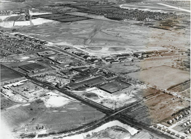
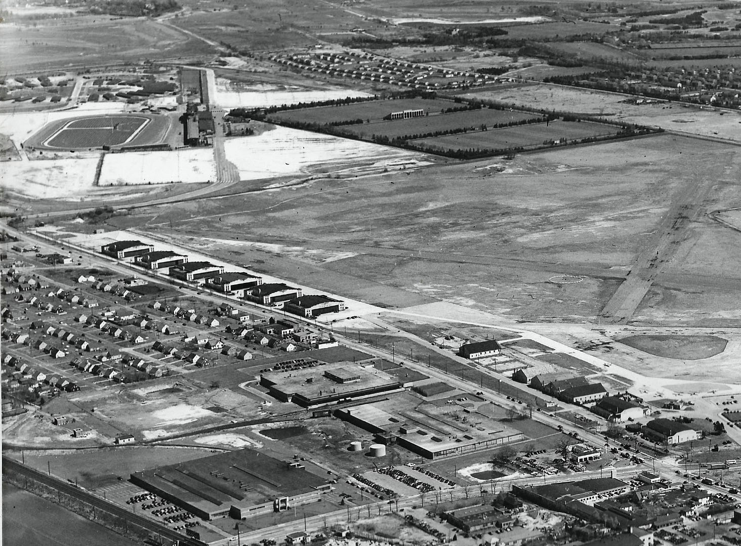
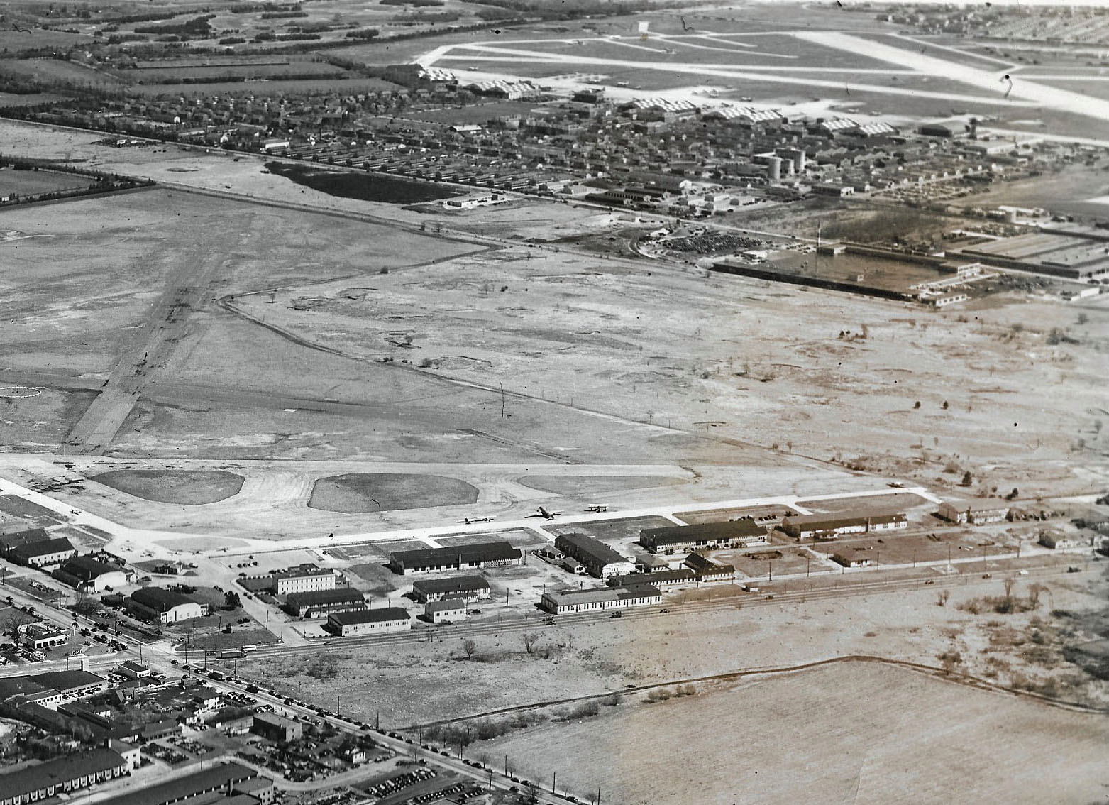
Looking southeast over Mineola, Westbury and Uniondale .
- The major roads
Glen Cove Road, Clinton Road, Old Country Road and Stewart Avenue
- The airfields
Roosevelt Field and Mitchel Field-amazing how close they were to each other.
- The major commercial buildings
See below Comments: Renewal Plastics, Mason Mint Candies
- Housing developments
Mitchel Gardens
- Link to Murray the K
Murray the K's World discotheque was located in 1966 in one of the Old Country Road hangars.
- The major sporting and historic events that occurred within this area
Many, see below Comments.
- Links to the Long Island Motor Parkway
See below Comments. Great view of the Old Country Road Motor Parkway Bridge.
- Links to the Vanderbilt Cup Race
The grandstand for the 1936 and 1937 Vanderbilt Cup Races can still be seen in the Mystery Foto, used for harness racing.
- The date of the Mystery Foto. Provide a rationale.
April 24, 1951. Rationale: Airplanes can be seen at Roosevelt before it closed. The Meadowbrook parkway had not been built yet.
Comments (12)
Congrats to Joe Osterle, Al Prete, David Miller, Michael Appice, Frank Femenias, Glenn, George Philippides, Steve Lucas, John Cunningham and Ernie for solving the Mystery Foto.
Kudos to everyone for a great job! Special kudos to Glenn and Ernie for their jpeg attachments!
Enjoy,
Howard Kroplick
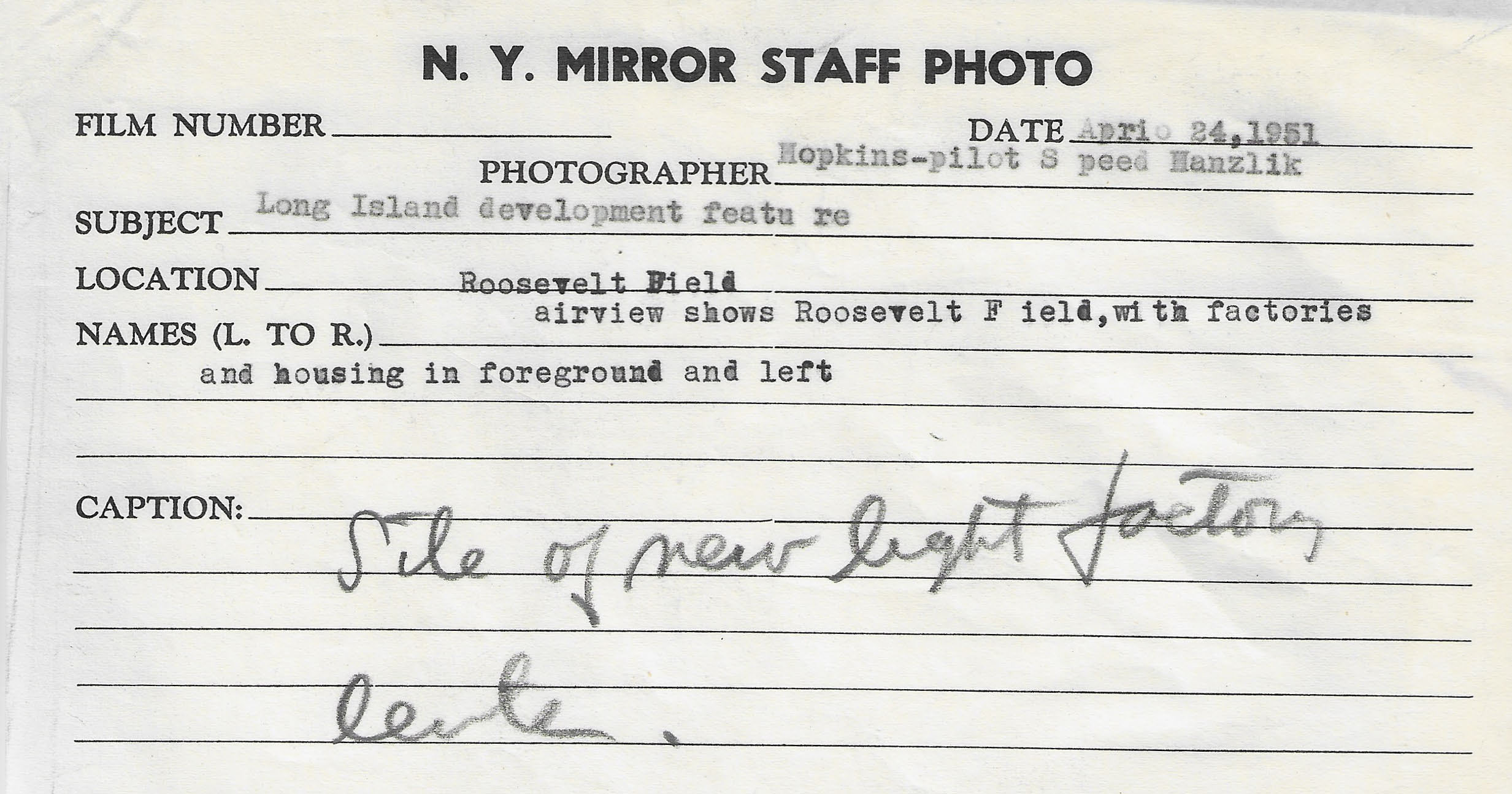
Reverse side of photo: New York Mirror Staff Photo, April 24, 1951- Roosevelt Field airview with factories and housing in foreground and left, Cpation: Site of new light factory center.
Al Velocci's notes on the Mystery Foto.
Close-Ups


Comments
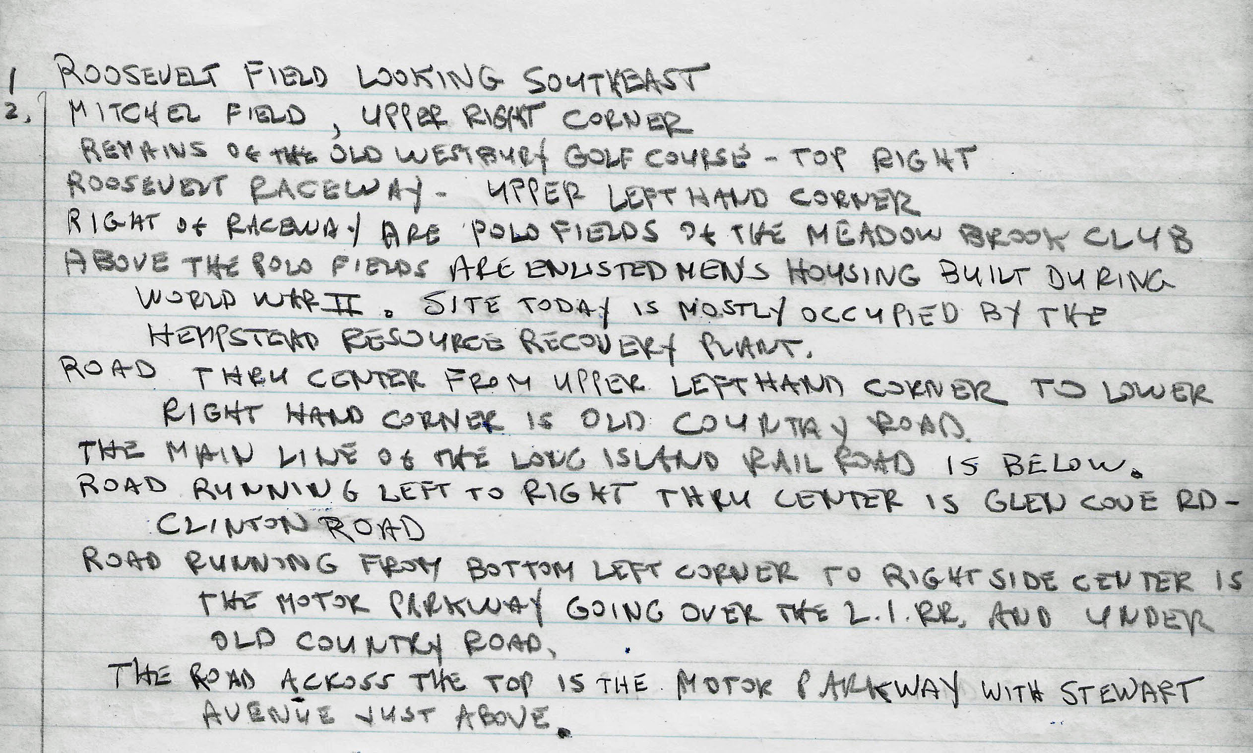
I see Roosevelt Field, the Roosevelt Racetrack. The LIMP heading south from Mineola over the LIRR and under Old Country Rd heading into Garden City. I see Mitchell Field. Houses in Carle Place, polo fields, and train spurs that served businesses north and south of the main tracks.
Westbury/Uniondale area. The photographer is facing southeast. Airports: Mitchel Field (top right), Roosevelt Field (center). Roads: Old Country Road (upper left to lower right), Clinton/Glen Cove Road (center left to center right). Buildings: Old hangars on S. side of Old Country Road, upper left. One of these was “Murray the K World” (arguably the first disco) in 1966. I also see the polo club and the LIRR main line. LIMP ran near Clinton Road then turned E. in the Roosevelt Field area.
I would date the photo from between 1947 and 1953. I see some inexpensive Levitt-type houses in the picture, but no sign of the Meadowbrook Parkway.
This photo is loaded, but that’s all I’ve got.
I took a closer look. I do believe that that is the LIMP in the lower right corner of the photo, passing over the LIRR and under Old Country Road. Both bridges are intact, but I don’t know when they were taken down.
The photographer is facing southeast hovering just north of the main line of the LIRR. Old country rd runs from the upper left to the lower right and Glen Cove rd runs almost horizontally in the picture in the middle. Roosevelt field takes up much of the upper half of this picture and Mitchel field can be seen on the upper right. Some military housing can be seen near the top right of the photo. Of course Charles Lindberg took off from the eastern portion of Roosevelt field here and Roosevelt Raceway is on the upper left. The LIMP is on the upper right and runs parallel to the Central LIRR branch just north of Mitchel field. Most of the Roosevelt field hangers still seem intact but the encroaching housing and commercial developments to the north gives a clue that airfield is probably near the end of its run. So I’m going to date the photo from about 1946 to 1951.
Looking south the picture is Roosevelt Field with the plane hangers upper left. Old Country Rd runs across the photo in front of the airport and Glen Cove Rd runs north and south. The village of Carle Place can be seen north of 6 hangers .One those hangers became Astro Land and radio host Murray the K,S club. Roosevelt Raceway is in the upper left host of a couple of Vanderbilt Cup races. The Vanderbilt Motor Parkway crosses Old County Rd in the photo on the right and crosses again on Glen Cove Rd top of photo behind Roosevelt Field . There were aerospace facilities and Mason Mint candies and printing company in the area. The year of the picture could be mid 1950’s cause Roosevelt Field shut down 1957 I think
Rare photo showing Motor Parkway and Roosevelt Airfield ramps in the same frame.
Mineola/Carle Place/Garden City/Westbury looking SE.
Motor Pkwy, LIRR, Old Country Rd, Clinton Rd, Guinea Woods Rd, Merrick Av in the distance.
Roosevelt Airfield in center, Mitchel Airfield at upper right.
Col. Lindbergh’s Hangar 16 (1927), Murray the K’s hangar further east adjacent to Old Country Rd where WWI flying ace Eddie Rickenbacker frequented, Roosevelt Harness Raceway Grandstand, and more….
Mitchel Gardens built in 1941, former Camp Mills 1918, Barracks and Mess Hall of Hazelhurst Field.
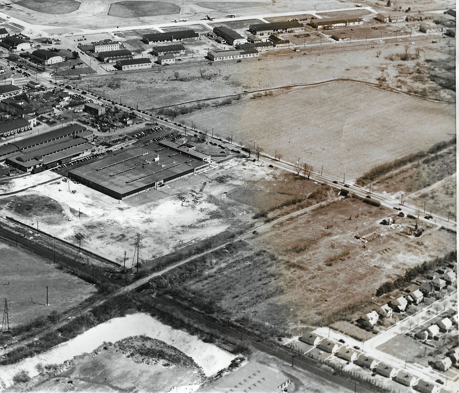
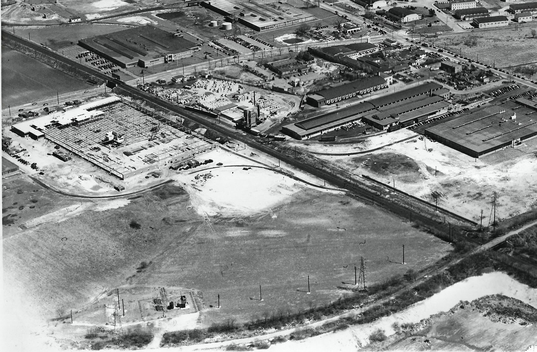
Future Roosevelt Shopping Center construction 1955.
R-34 Derigible landing 1918, 1908-10, 36, 37, 60 Vanderbilt Cup Races, Lindberghs solo flight to Paris 1927, Meadow Brook Hunt Club and Polo Grounds.
Mineola LIRR pkwy bridge, Old Country Rd hwy bridge, Meadow Brook Hunt Club hwy bridge, Roosevelt Field hwy bridge, Meadow Brook lodge, Merrick Av pkwy bridge, Bellmore Rd pkwy bridge, Stewart Av hwy bridge.
Date is 1950-1955, between removal of Old Country Rd hwy bridge 1950s, and before construction of Roosevelt Field Shopping Center 1955 and Roosevelt Field hangar demolitions of 1956.
Picture taken just over Carle Place/Mineola towns line going a little south east. Around early 1950’s[1949-1952]
1.Glen Cove Rd. 2.Old Country Rd. 3.Murry The K’S 3B-Space Land 3C-Joe Cranes Parachutes 4.Roosevelt Raceway horse racing trotters 5.Cherry Lane 6.Mason Mints 7.Clinton AVE. 8.Roosevelt Air Field or Hempstead Plains Aerodrome 9.Mitchel Air Force Base 10.Coal Bins 11.Stewart Ave. 12.Parade Grounds 13.Renewal Plastics 14.Motor Parkway 15. L.I.R.R.
The location and orientation of the photographer:
Over Mineola/Carle Place/Garden City looking southeast
The major roads:
Glen Cove Rd becoming Clinton Rd when it crosses Old Country Rd, Long Island motor parkway bottom right crossing OCR and again in upper left running to the east . In the distance Stewart Avenue.
The airfields: Roosevelt Field and Mitchell Field in distance
The major commercial buildings: On corner of OCR and Clinton is the old candy factory ( Mason Mints, Dots) on Glen Cove Rd near LIRR is Consolidated Lithograph. South of lIRR are the buildings of Smith and Hicks farms and Laboratory Furniture
Housing developments: Mitchell Gardents, top left.
Link to Murray the K: Murray the K ran a Rock and Roll/dance club out of one of the old airplane hangars on OCR, near the Clinton Rd intersection. Called “The World”
The major sporting and historic events that occurred within this area:
Vanderbilt Cup Races, Roosevelt Raceway for motor racing and later horse races/harness racing, Polo at the Meadowbrook Polo Club, Lindbergs transatlantic flight out of Roosevelt Field
Links to the Long Island Motor Parkway: LIMP seen on bottom right and upper right of picture.You can see the Old Country bridge and LIRR bridge lower right.
Links to the Vanderbilt Cup Race: They used the tracks/roads leading in to Raceway
The date of the Mystery Foto. Provide a rationale:
Between 1941 and 1954 since Mitchell Gardens, Meadowbrook Pologrounds, are still intact and there is no evidence of the Meadowbrook pkwy or the house I grew up in( Avalon Rd, just west of Clinton)-which were built in 1955
We are over Mineola / Carle Place looking southeast toward Westbury & East Garden City. Along with the LIMP R-O-W, major roads include Glen Cove Road, Clinton Road, Old Country Road, Stewart Avenue and Merrick Avenue in the distance. The airfields are Roosevelt and Mitchel Fields. I think Mitchel Gardens housing is visible. Murray The K’s World, a disco / nightclub, opened in April, 1966 in one of the Roosevelt Field hangars along Old Country Road. I believe it was the sixth one in from the left edge of the photo. Among the the many historic aviation events that took place in the area, the most famous was Lindbergh’s 1927 solo flight. Sporting events included the Messenger Stakes and 1983 American Trotting Championship at Roosevelt Raceway. Links to the LIMP include the R-O-W starting near the lower left, continuing over the LIRR, under Old Country Road and then curving east on the top of the photo. The 1908, 1909, and 1910 V. C. Races ran through the top left via the temporary road connecting Ellison Avenue to the LIMP. Since the Roosevelt Raceway harness track looks quite new, I’ll guess the date to be around 1940-1941.
Roosevelt and Mitchel fields. looking southeast. Old Country Road, LIMP, stewart ave, merrick ave all in photo. Central RR and LIRR also in photo. The Roosevelt and mitchel hangars are visible. So are some factories on stewart ave. Some of the housing developments are the mitchel field housing and the Ladenburg estate. One of the roosevelt hangars became murray the k’s world in 1966. The 1926 pga championship was played at salisbury and lindbergh’s solo flight left from here.
following LIMP structures in frame(some not that visible)
-Mineola LIRR bridge
-OCR bridge
-Merrick Road bridge
-Bellmore road bridge
-Stewart Ave bridge
-Meadowbrook Hunt club and roosevelt field parkway bridges over central RR are also in frame.
Motor Parkway looks closed but roosevelt field mall hasnt been built yet. My guess in early 1950s.
Have a Happy Fourth!
• The location and orientation of the photographer
Mineola, over west Westbury Ave, looking south east
• The major roads
Old Country Road & Stewart Ave going L to R, Clinton Ave, Merrick Rd
LIRR Main line and also Stewart Extension
• The airfields
Roosevelt Field and Mitchel Field
• The major commercial buildings
Several hangers from Mitchel. Links to Bob Emery maps of the LIRR sidings below
• Housing developments
AFAIK the housing by Stewart Ave was all for Mitchel Field
• Link to Murray the K
Murray the K’s World was in one of the hangers along OCR.
• The major sporting and historic events that occurred within this area
Vanderbilt Cup and later Roosevelt Field harness raceway
• Links to the Long Island Motor Parkway
Oh that old thing? Yeah, prominently middle bottom where it bridges over the LIRR main line. Also seen along the top below & parallel to Stewart Ave.
• Links to the Vanderbilt Cup Race
Right where the harness track is
• The date of the Mystery Foto. Provide a rationale.
Between ’40 (when harness raceway opened) and ‘56 when the Meadowbrook parkway came thru
Raceway: 40 parkway:50-56
“Bob Emery (1925-1995) was an LIRR Conductor and Historian who hand-drew an amazing collection of track maps of the LIRR in the 1950’s and 1960’s.”
http://www.trainsarefun.com/lirr/mineola/EmeryMapsMineolaHempstead/Emery_Mineola_MP19-20_5-1958.jpg
http://www.trainsarefun.com/lirr/lirrtrackmaps/Garden-City-Secondary-1966.jpg
http://lirrhistory.com/emerymaps.htm
Glenn, The building you labeled # 13 was actually the Laboratory Furniture building opening May 1951. At that time Renwal occupied the building south of the Mason Au Magenheimer plant today occupied by Macy’s. Renwal would later occupy the building on the east side of Laboratory Furniture. Prior to the construction of Laboratory Furniture, Dade Brothers, the owners of the property, tried to open a Drive-In Theater on that site The Town turned them down.
Amazing details Al!
Need to make a couple corrections to my post. Renwal occupied the building NORTH of the U.S. Printing & Lithographing Co. building. Mason was on the east side of U. S. Litho.
From my biased perspective the most important building captured in these photos is Hanger #16, near the corner of OCR and Clinton Avenue, where Lindbergh’s Spirit of St. Louis spent the last few days before he took it solo across the Atlantic to Paris. It is notable too, that the hanger remained intact until the demise of Roosevelt Field. Hard to believe that such an historic building that figures so prominently in the development of aviation could stand there largely obscure for another 25 years before being crushed by the development of “progress.” What a shame.