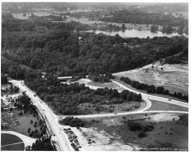
Mystery Foto #24 Solved: A 1952 Aerial View of Lake Success
Did you identify this Fairchild Aerial Survey?
Answers to the Mystery Foto questions:
- Identify the location and orientation of the aerial photographer
Village of Lake Success. Photographer was looking northwest.
- Identify the major roads
Marcus Avenue, Lakeville Road and Northern State Parkway (see Brian McCarthy's Comment). Robert Moses' Motor Parkway Bridge over Northern State Parkway can be seen overgrown with bushes.
- Which road in the Foto was used for the course(s) of the Vanderbilt Cup Race(s)?
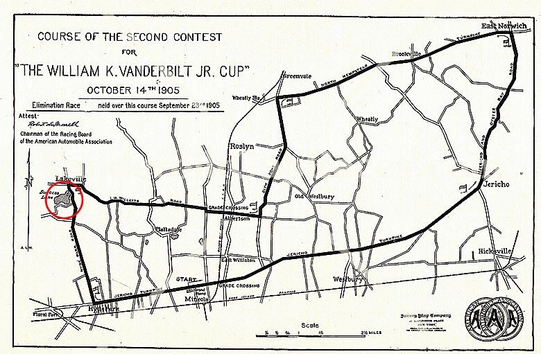
This section of Lakeville Road was part of the 1905 Vanderbilt Cup Race course.
- Which building(s) and structure(s) in the Foto are associated with William K. Vanderbilt, Jr. and the Motor Parkway?
Deepdale Mansion (Willie K's residence)and the New York State Police Headquarters (Willie K's guest lodge)
- Why are automobiles parked in the Mystery Foto?
Likely overflow parking from the Sperry Plant.
- What year was the aerial taken? Provide a rationale.
June 10, 1951. Rationale: The Tanners Road residential development was just begging on the right.
Comments (18)
Great response to the this weekend's Mystery Foto.
Congrats to Robert Kent, Steven Vilardi, Greg O., Lee Brodsky, Andy, Al Prete, Paul Parisi, Casey DeNicola, George Philippides, Art Kleiner, Roy Warner, Steven Waldman, Sam Berliner III, Steve Lucas, Brian McCarthy, David Stephan, and Frank Femenias.
Kudos to Paul Parisi and Steve Lucas who identified this section of Lakeville Road as part of the 1905 Vanderbilt Cup Race course.
Thanks to Art Kleiner and Brian McCarthy for the jpeg documentation.
Be Safe, Stay Healthy, Save Lives,
Howard Kroplick
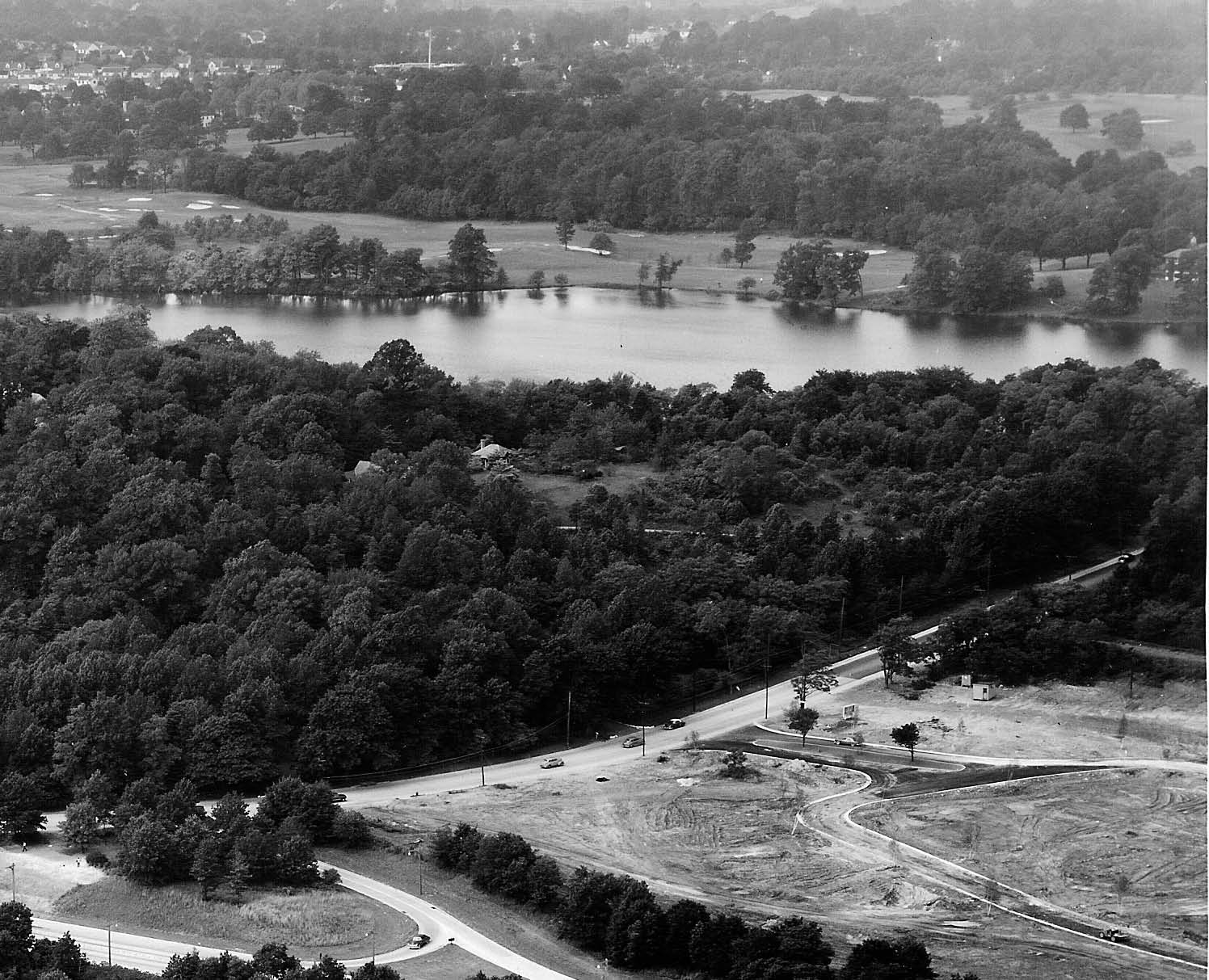
Close-Ups
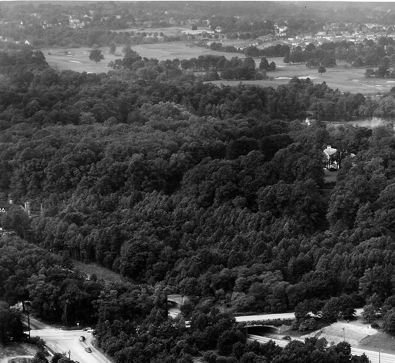
The Robert Moses' Motor Parkway Bridge over Northern State Parkway can be seen west of Lakeville Road. The Deepdale Mansion is on the right and the New York State Headquarters can be seen on the left.
The Tanner Road Development under construction off Lakeville Road.
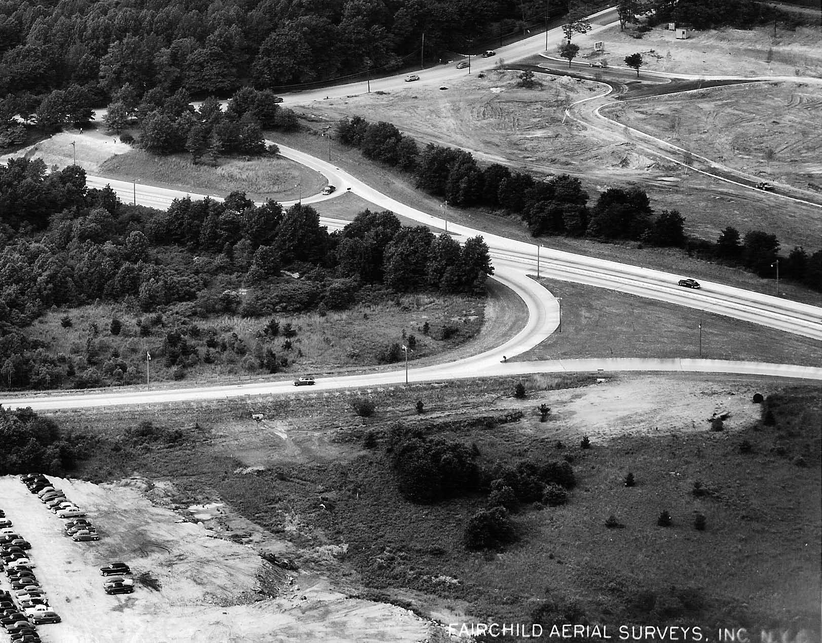
Overflow parking from the Sperry Plant.
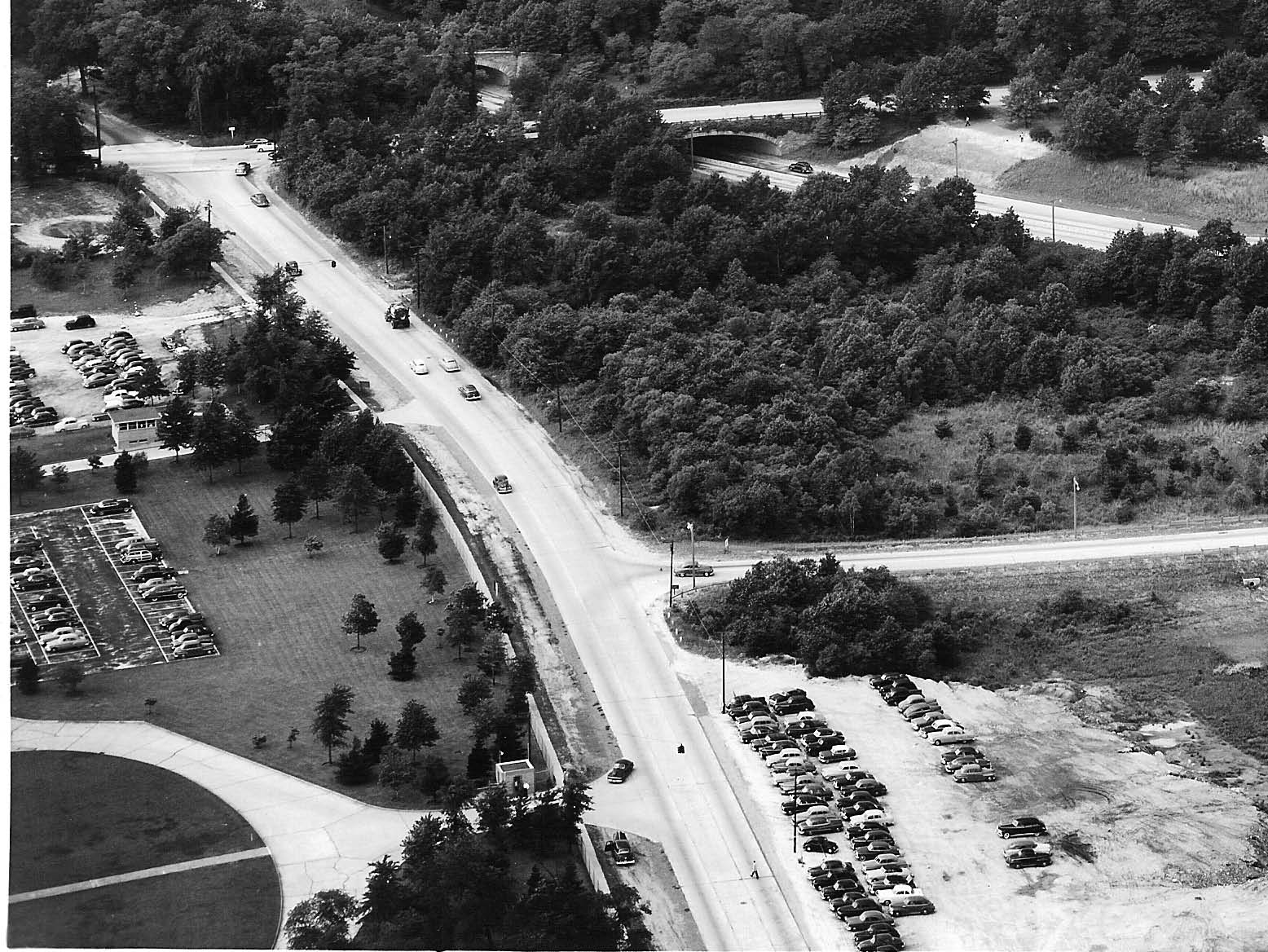
Marcus Avenue. Note the guardhouse in at the Sperry Plant entrance
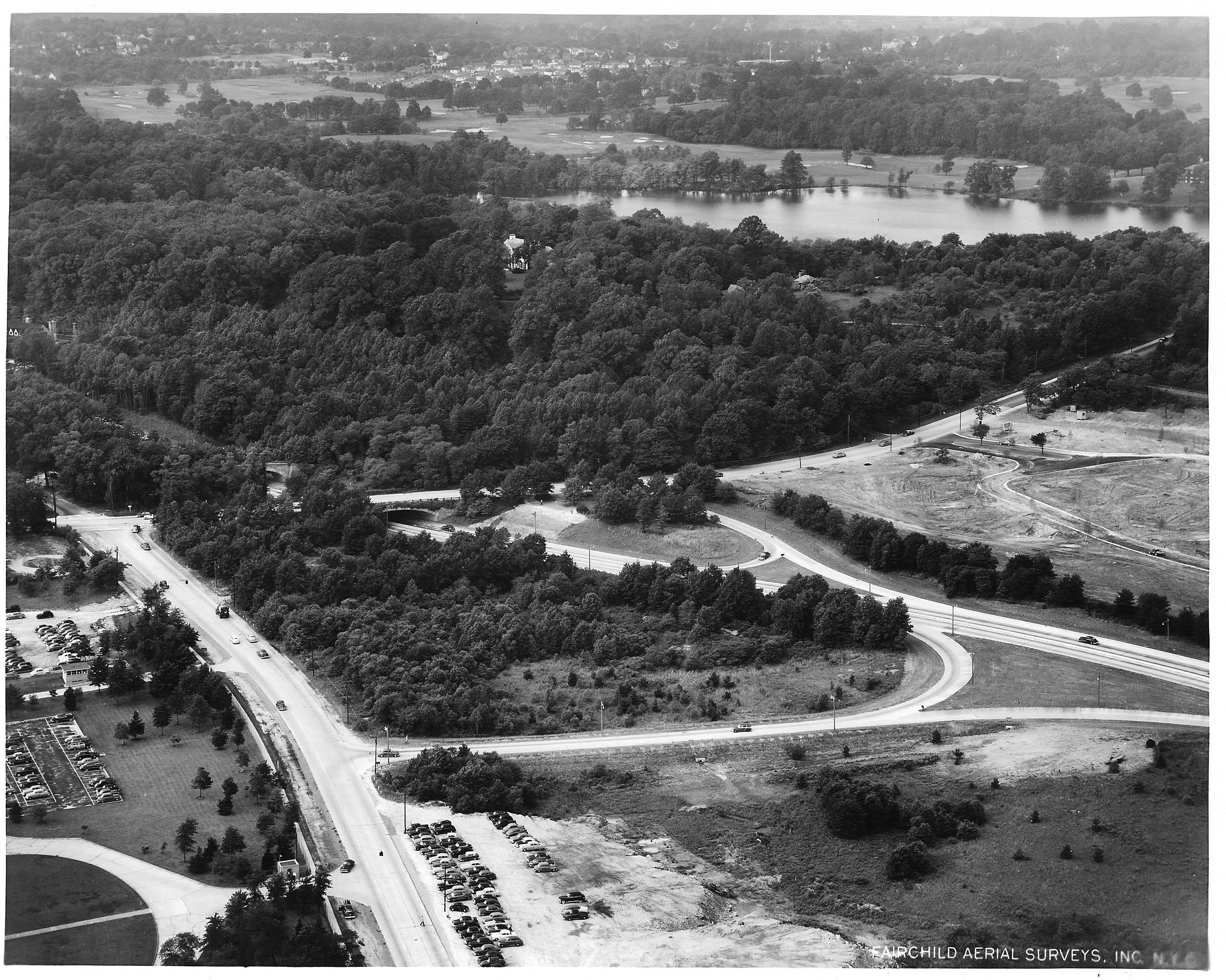
Another Fairchild Aerial Survey of the Area
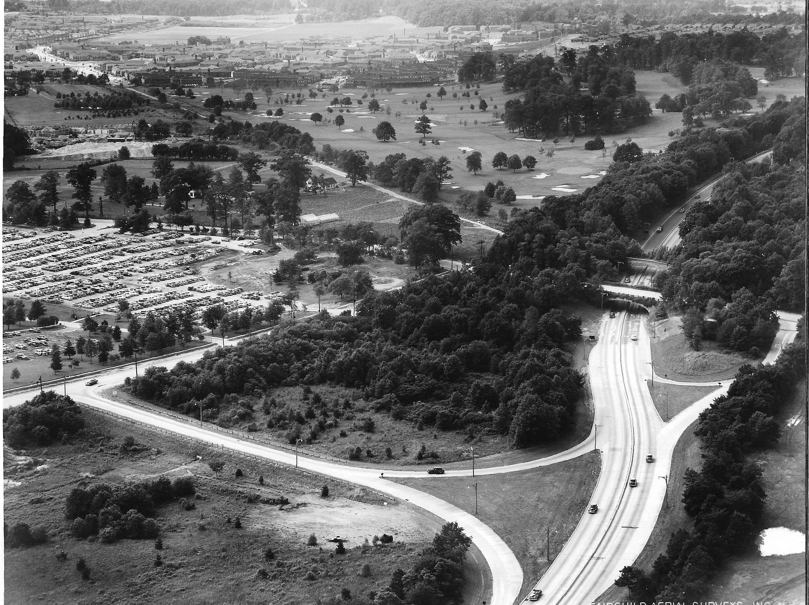
June 10, 1952 View looking Southwest taken during the same flight. The Long Island Jewish Hospital was beginning construction. The Motor Parkway right-of-way was still clearly visible. The Sperry parking lot was full.
1905 Vanderbilt Cup Race Course


Comments
It is the exit off the Northern State by Lakeville Road. Lake Success is seen in the NW corner of the photo. On the left is Marcus Ave, the middle is Northern State Parkway. Running N-S is Lakeville Road with Great Neck to the North. The overpass west of Lakeville Road is for the Vanderbilt Parkway leading to the Vanderbilt estate. The UN met at the Sperry Plant in those days which is why the cars are parked there. Probably taken in the 1950s as when the parkway was widened the overpass for the Vanderbilt estate was taken down,
#24 appears to be looking west at northern state parkway with the large road being Marcus Ave at lake vile road NS overpass. Lake success in the background and temp headquarters of the United Nations at the sperry corporation. Vanderbuilt house is on that lake along with the motor parkway
-Identify the location and orientation of the aerial photographer
Looking North West at mostly Willie K’s Deepdale estate property in Lake Success. Lake towards the top of the photo.
-Identify the major roads
Northern State Pkwy, Lakeville Rd, Marcus Ave
-Which road in the Foto was used for the course(s) of the Vanderbilt Cup Race(s)?
Lakeville Road
-Which building(s) and structure(s) in the Foto are associated with William K. Vanderbilt, Jr. and the Motor Parkway?
Deepdale estate, the NS Pkwy LIMP bridge, Willie K lodge (NYS police barracks)
-Why are automobiles parked in the Mystery Foto?
-What year was the aerial taken? Provide a rationale.
Judging by the newly built street, (just North of the NSP and East of Lakeville) that does not have houses yet, I’ll guess this was 1951. The last year for the United Nations at this location, which is the likely reason for the parked cars.
So cool -
I got this ... Lake Success - Lakeville Road Areas
Add -
Vanderbilt Parkway Bridge over NSP
Vanderbilt Mansion - Lake Success
Northern State Pkwy Bridge
UN Headquarters - Parking Area’s
Looks like an aerial of the exit and entrance ramp of the Northern State pleat at Marcus Ave.
you can see the VMP as it crosses Lakeville Rd..
looks like Vanderbilt Lake Success home is visible as well as his golf course.
Year looks to be mid-1940’s
Cars parked in side of road were overflow parking for sperry’s, United Nations or League of Nations building . Mid forties.
The photographer is looking northwest over the village of Lake Success. That’s Marcus Avenue on the left. In the middle is the entrance/exit ramp from Marcus Avenue to the Northern State Parkway. The parkway is to the right of the ramp, and Lakeville Road can be seen above the parkway.
I see that Lakeville Road was part of the course of the 1906 VCR. Is that Willie K.‘s Deepdale mansion barely visible between Lakeville Road and the lake?
Sperry Gyro had a building near this area for many years. My brother worked there for a long time. The building was temporarily the home of the United Nations from 1946 to 1951. I would say that the picture was taken around 1955, judging by the cars. I have no idea why the cars were parked there. Overflow from the Sperry parking lot?
1) orientation of photographer is facing west
2) Lakeville Rd, Marcus ave, Northern State Pkwy
3) Lakeville Rd 1905 cup race
4) Deepdale Mansion, Northern state pkwy Motor pkwy bridge, remnants of the LIMP on the far right of photo. Just out of the right side frame was the LIMP toll house
5) Overflow parking for Sperry and the United Nations headquarters
6) 1951or 1952. The new housing development on the right side of the photo was built in 1953. This was from research of home listings for sale on Olive st and Tanners rd which lists the year the homes were built. The streets have been made so homes were soon to follow. A 1950 aerial photo shows no roads in the housing development
This is definitely Northern state pkwy and Marcus Ave in Lake Success.The parked cars are for the United Nations.The entrance off Marcus and circular drive are for the UN.The road running left to right in center of photo is Lakeville Rd.Orientation is looking North-North west. The estate hiding in the woods is Vanderbilt’s “Deepdale”.The body of water is Lake Success and beyond that is the Deepdale golf course.The UN was there from 1946-1952.The new roads off Marcus and North of the parkway are Tanners road and Olive street.
Looking Northwest at Lake Success. Main roads are Lakeville Rd, upper right to left, bisecting Northern State parkway and Marcus Avenue underneath. I believe you can see the Robert Moses Motor Parkway Bridge over Northern state pkwy, and I imagine, the LIMP was used for the race.Vanderbilt structures include the bridge/motor parkway, Deepdale estate, near the lake.
I believe the cars are parked outside of the Sperry Gyroscope plant.
Date of photo, after 1941 when Sperry plant was built, but likely prior to 1953, as there are no houses on Tanners road in the picture.
From Art Kleiner
Lake Success, looking northwest
Northern State Parkway, Marcus Avenue, Lakeville Road
Willie K’s Deepdale estate and garage, and the Marcus Avenue Motor Parkway Bridge
Parking for the Sperry Corporation building across the street
Picture taken in 1952 - the entrance/exit ramps to the Northern State were not there in a 1950, picture, the extra Sperry parking appeared in 1951, and the homes north of The Northern State and east of Lakeville Road were built in 1953. The attached photo from Dec. 1951 doesn’t even show the beginnings of the roads in the development but the mystery photo does, but no homes.
Looking northeast from Marcus Avenue from the “entrance/exit Ave to the eastbound Northern State Parkway for Lakeville Rd. very near my office in the Lake Success Quadrangle (of the future). The Motor Parkway Bridge is visible, as are Lake Success and the entrance/exit to the Sperry Rand facilities on the other side of Marcus Avenue. It’s hard for me, with my eyes, to discern whether any of the parked cars are “modern” (1946-1950). If so, the Sperry facilities became the temporary HQ Secretariat of the UN; there’s a plaque there today.
Location is Lake Success Ny view west
2. Lakeville Road crossing Northern State Parkway, Marcus Ave is parallel left to Northern State Parkway
3. Motor Parkway far right to be crossing Lakeville Road and crossing Northhern State Parkway concealed by foliage upper left
4 upper right by the bordering east side of lake are the 2 building associated with the Vandebilt races and william K Vanderbilt Jr
5 Automobiles parked for Sperry Rand and overflow from UN temporary building
6 photo taken about 1951, new lighting( Taller poles) on Northern State Parkway and newly constructed exit ramp , original was closer to Lakeville Road
Looking NW over confluence of LIMP, NSP, Marcus, and Lakeville with both bridges over NSP visible, Lake Success beyond, and Willie’s Deepdale mansion deep in der voods. Parking for nascent UN at Sperry or for war-time Sperry? LIMP RoW barely visible to E of Lakeville at right margin (1/3-way down). Anothe rgret pic; thanks. Sam, III
We are looking northwest over Marcus Avenue in the North New Hyde Park / Lake Success area. In addition to Marcus Avenue, there is also Lakeville Road and the Northern State Parkway. The 1905 Vanderbilt Cup Race course utilized this portion of Lakeville Road. The 1906 race also used Lakeville Road but that section is just out of the picture to the north. We can see the LIMP bridge over the NSP, Willie K’s Deepdale Estate, possibly the remnants of an abutment for the bridge over Marcus Avenue, and a small section of the LIMP itself. I thought the Great Neck lodge would be visible but it must be just off the right side. Judging by the cars in the photo, I would guess the date to be about 1954. If this date is accurate, then the cars all belong to employees of Sperry Gyroscope, located on the south side of Marcus Avenue. The U. N. Headquarters had moved to their new site in 1951.
View is NW above Lake Success NY. Lakeville Rd was part of the 1905 & 1906 VCR’s. North of Marcus Ave. must have been additional parking for the United Nations, they were housed within the Sperry Plant 1946 thru 1952. Think they stayed a little longer than 1952. This mystery foto shows the onset of Tanners Rd & Olive St. The 1952 aerial below still shows farmland. The 1956 aerial shows full development. So I’m guessing 1954. Hope my wording on the aerial answers the other questions ????
Looking west over Marcus Avenue, Lake Success. NSP, Lakeville Rd. (cup race road, and the remains of LIMP can be seen, as well as the beginnings of Fawn Ridge, Olive St., and Tanners Rd. The Deepdale mansion and guest lodge can be seen in the picture.
By deduction, this picture has to be taken after 1951 and before 1953.
The 1951 NYC aerial that includes this part of Nassau County still shows the two eastbound NSP exits to Marcus Avenue, whereas this photo shows only some remains of exit that was discontinued.
The parking lot to the west of the oval is larger than the lot in the 1951 aerial.
North of NSP houses that were built in 1953 (Zillow) have yet to be constructed and the transaction that enabled this development dates to 12/1951. Given this narrow window, the picture must be from Summer 1952.
The cars parked are Sperry employees because the United Nations had left the site in May, 1951. A picture dated 5/18/1951 looking N from slightly behind the western edge of the U.N. temporary HQ building, posted by the Brazil Mission UN (pic.twitter.com/xSSmRl5KtS), shows some of the features of the mystery photo, with matching trees slightly shorter.
This answer supports some comments to the Mystery Foto #28 of July 11, 2016. That post states the UN had its headquarters from 1946 to 1952, a common misstatement that some there correct. That photo must be from before 1951 as the current eastbound exit does not yet exist as some commenters also note there.
In that post, two other pictures are listed as “Sperry Plant, circa 1952,” which also appear elsewhere on this site so labeled. While the second picture is consistent to 1952, the first picture with the country flags cannot be from that year as the country flags had been removed by 1952. From trees that are visible, the flags picture is pre-1950 and likely from 1946-47. Apologies, if this error was corrected in a later post that I did not see.
This amazing crispy photo is over Lake Success looking WNW. A good portion of Vanderbilt Deepdale Estate’s 560 acres is viewed in the jungle area and more. Marcus Av bottom left, NSP bottom right, Lakeville Rd and bridge in the center, Motor Pkwy bridge hiding behind Lakeville Rd, Great Neck lodge entrance/exit ramp at extreme right center. Lakeville Rd was once used in a VCR race. Deepdale Estate and Guest lodge (later NYS Police Barracks), LIMP bridge west over NSP (built by Robert Moses), Great Neck lodge entrance/exit ramp, all associated with Willie K and the Motor Pkwy. Autos parked beside Marcus Av possibly for additional parking for the UN Headquarters or Sperry. Year of photo is tricky, will try to come back for more.
Great answers by all; more technical history was learned here. The additional aerial was great help Howard! It help fill the scenario of the mystery photo. Thank you Howard and everyone for your knowledge of this early Long Island history.
Dang - missed the guesthouse-cum-barracks! That VCR course map reminds me that we have studiously ignored ol’ Isaac Underhill Willets (although NOT his son, Edwin C. - Myst. Foto #17 of 30 Apr 2018) and the eponymous road that has been so truncated over the years; see my LIMP Page 3, <http://sbiii.com/limpkwy2.html#IUW>, for a bit more. [Just blew a Myst. Foto!] I, for one, would enjoy a blog just on the full length of the old I. U. Willets Road. Sam, III
Sam - IU Willets Rd history sounds an interesting subject. Its RoW was included on the Motor Parkway online map in pale blue, along with other roadways no longer existing. Appears Moses dismembered and paved over it with LIE and NSP. I would like to investigate if Bates Rd was once the same IU Willets. Perhaps an old Hagstom can clarify this.
Frank, the extant western end of IUW Rd. is the present driveway for the Buckley School and camp, a private way. My pic from the far end at <http://sbiii.com/limpkwy4.html#oldcthrd> is missing but, as I recall, you can see through to NSP there. It’s only some 50 yards from 90 IUW Rd. to NSP. Howard, care to start a new thread? Sam, III
I finally found the missing 03 Apr 2000 pic of NSP from IUW and restored it at <http://sbiii.com/limpkwy4.html#oldcthrd>. Yes, you CAN see through to NSP, but not terribly well! Sam, III
Sam, sorry I meant pre LIE and NSP, where old IUW Rd meets today’s Bates Rd in Lake Success, just east of the Queens line
From Art Kleiner:
Speaking of Lake Success - I came across this undated Lazarnick photo in the Detroit Library Digital Collection and wonder if anyone can help date it. Possibly the advertising signs on the utility pole can offer some clues but I can’t make them out. If I didn’t know better I would have thought the top most sign is promoting a cellular start-up! Maybe someone was way ahead of their time!
Art, possibly “Cellar Star”, and below it, “Garfield Tson…” I’ve seen the Garfield ad posted elsewhere in an early 1900s photo, and written the same way.
From Art Kleiner:
Thanks Frank - good leads to do more research on.
Art, also the Lake Success pole photo is looking approximately North or Northwest based on the pole’s shadow. Two possible locations on old I.U. Willets Road in Lake Success below.
Resending again.
Or, next
This may help, Art.
Re: I. U. Willets Rd. Today the western terminus of I.U. Willets Rd. butts up against the south side on the Northern State Parkway west of the Buckley School complex beyond several residences. Prior to the building of the Northern State Parkway the western terminus was at today’s North Service Rd. of the LIE. Over the years maps have that roadway as the Old Westbury Rd., Powerhouse Rd. Nassau Blvd. Horace Harding Blvd. extension, Rte 25D, and even as I.U. Willets Rd. Take your choice. Hollow Road, between the South Service Rd. of the LIE and New Hyde Park Rd., was I. U. Willets Rd. pre LIE. Up until a couple of years ago, I. U. Willets Rd existed east of New Hyde Park Rd. on the north side of the north exit of west bound traffic of the Northern State Pky. It led to the Manhasset Lakeville Water District complex and to a residence beyond. There was even a street sign with that designation. It all disappeared with the construction of the condos and the office building. Prior to the construction of the LIE in that area, New Hyde Park Rd ended at I. U. Willets Rd. In those days, before Northern State Parkway was widened in the early 1960’s, there was only one Northern State Parkway exit at New Hyde Park Rd. It was on the south side of the Parkway and west of New Hyde Park and dumped you out onto I.U. Willets Rd. today’s Hollow Rd. I’ve been told that originally it was to be called just Willets Rd. but some felt it would be confused with Willis Ave. hence the adding of the intials.
Re IUW/Bates, I have just spent an inordinate amount of time looking for documentation I simply could not find; I documented the entire stretch of the N. Service Road/Fairway Drive/Horace Harding Boulevard/Bates Road east to west some 20 years ago. DING! As I started writing this, it hit me - it’s *NOT* LIMP related at all but, rather, on my NYC Odd Streets page, <http://sbiii.com/oddstrts.html#nassblvd>, and it was on 16 May 2002. It follows the N. Svce. Rd. west past HH Blvd./(yet another)Nassau Blvd. to HH Expressway w/b just west of Little Neck Pkwy. What a tangle of roadnames at the county line! I’m appending my map of all this herewith. Sam, III
From Art Kleiner:
Brian, thanks for the enlargement - we’re getting a bit off topic but here’s some final info. on Garfield’s Tea Syrup which was on the sign post.
Sam, I. U. Willets Road dates back to 1870. The first section built, about four miles long, was from the Old Westbury Post Office westward to Herricks area. I’m thinking to Shelter Rock Rd because at the time Issac had a farm in that area. Confusing the issue is that Shelter Rock Rd. at the time, was also called Old Court House Rd. It appears I. U. Willets Rd. was named after him as he was a strong proponent of more and better roads.
Thanks Art! The recipe will be helpful if I can’t find this at CVS. : )
From Art Kleiner:
At the request of Al Velocci, I’m posting some Hagstrom maps adding to his comments. First is 1939, second is 1946 and the third is 1954. The 1954 map shows I.U. Willets Road as the northern border of the Link Golf Course, continuing west past the Northern State and New Hyde Park Road and meeting Power House Road (notice it missing “Old). Does this clear things up or make it more confusing!
Art, I never unpacked my old Hagstrom’s but I’d respectfully (who - ME?) suggest that they’re in reverse order. Thanks, though. How about a current/latest Hagstrom’s/McMillan/Langenscheidt’s/Kappa/whatever of the same area? My image processor is on the fritz or I’d do it from Google Maps. Sam, III
From Art Kleiner:
Sam, I would have thought that also but I double checked and found the order to be correct. I did find that the first one (1939) was actually a Dolph & Stewart map. That one and the 1946 Hagstrom are found on-line at historicmapworks.com.
http://www.historicmapworks.com/Atlas/US/692/
http://www.historicmapworks.com/Atlas/US/32436/
The 1954 Hagstrom is in my collection and clearly says 1954.
From Art Kleiner:
Scratch the first pic above should have been this one showing the Dolph & Stewart cover page.
Great info by all, much thanks! Below is a 1926 aerial of IUW Rd, before Moses’ parkway came to town. It was a winding country road in the Lake Success/Manhasset Hills section.
O. K., as long as we’re diverging, I’ll bite; why “Powerhouse” Road? This can be a “Mystery Question”. Sam, III
Art, Thanks for posting the maps, they clearly show where I. U. Willets Rd. ended on Power House Rd. At the request of a couple of curious neighbors of mine with an interest in local history, I’m putting the location at a little west the main entrance of today’s Deepdale Country Club. Back to I.U. Willets Rd. east of New Hyde Park Rd., the address on the Manhasset- Lakeville Water District building says 65 I. U. Willets Rd. So, at least technically, it still exists. Ok…. Power House Rd., any interest in where that came from?
Ha, Al! Two minds; one thought. If we DO go there, though, folks/HK, new thread, please. Sam, III
Almost forgot; if we get into it, why “Power House” in some instances and “Powerhouse” in others? ‘Tis a puzzlement. Sam, III
Yes Power House NY25D. I have no info on it but appears it came after I.U. Willets by its straight course.
OFF-TOPIC TO ART-
I’m late the the Garfield Tea party…The “tea(-syrup)” “activated sluggish bowels.”
Research Stillman Remedies Co to learn more.
Top sign is CELLULOSE STARCH, both the name of a company (in Phila first, later in New Haven) and its laundry starch product.
Thanks, David. Will keep both products in mind - you never know when you’ll need help!
Frank, Your comments of June 19, regarding Power House Rd./NY25D made me take another look at that scenario and,... discovered I made a HUGE mistake. I said that I. U. Willets Rd. joined Power House Rd./ Old Westbury Rd. Actually, Its the other way around, The 1914 Belcher Hyde Atlas of Nassau County clearly has the western terminus of Power House/Old Westbury Rd. at Shelter Rock Rd. It also shows that west of that point, heading in a south west direction, are dotted lines stating “proposed line of new road” that connects to I. U. Willets Rd., Now I think I know why that road designation is so convoluted and confusing. The state built that section between Shelter Rock and I. U. Willets and, some where along the line, they designated every thing west ward as Route 25D,.... adding to the mess. Thanks to Frank’s observation all is right with the world again.
From Art Kleiner:
Al has provided the attached map from the 1914 Belcher Hyde Altas which documents his comments above. I’ve annotated the map with the roads under discussion.
New thread for sure!
Al-The true ending of IUW was at the t-intersection (arrow in the 1900 USGS map overlaid on current map), where it met the N-S Valley Rd (Community Dr.). The east-west road there was an early Lakeville Road, which is mostly called Bates Road in Queens today.
Sam, III-The “Power House” is labeled in the 1947 USGS overlay and is the current PSE&G complex. The 1914 map shows this as Nassau Light & Power Co., of which Harry Payne Whitney was a director.
Note in the 1941 map overlay, “Old Powerhouse Rd.” and “Power House Rd.,” which part of the NSP (lower red ribbon) overlays. Not shown is an western segment of Power House that forms the LIE south service road. (Part of that segment west of Hollow Lane is the part of IUW that became Power House Rd.)
The old and new (not built to the 1914 planned routing), merge just west of Mineola Rd.
Since 1941, the western part of the “old” road has been erased starting at Christopher Morley Park. (Does the 1941 map have a mapping error for the NSP because it shows a “3 Lane” segment that deviates from the current parkway?)
Ooh, lookit! Bottom right of Art’s 1914 map. “Platsdale” with one “T”! Sam, III
Bottom LEFT - sorry.
David, I think we can agree that sometimes map producers were careless in identifying some roadways and not accurately correcting some changes leading to much confusion. For example, your reference to today’s Community Drive. The 1914 Belcher Hyde Atlas of Nassau County identifies it as Smoketown Rd. AND Hyde Park Rd. In 1925 it’s known as New Hyde Park Rd. AND Valley Rd. In the 1930’s it’s known only as New Hyde Park Rd. In the early 1940’s to the early 1950’s -Valley Rd. AND New Hyde Park Rd. In 1954-Valley Rd. AND Community Dr.
Now for I .U. Willets Rd. ... The Hagstrom Nassau County Atlas -1954. From east to west….From Ellison Ave./Old Westbury Rd. to Glen Cove Rd. it’s I. U. Willets Rd. From Glen Cove Rd. to Willis Ave.-Albertson Station. From Willis Ave to Searingtown Rd-Nassau Blvd. From Searingtown Rd. to New Hyde Park Rd.- I. U. Willets Rd. again. From New Hyde Park Rd. to Lakeville Rd. - Old Westbury Rd. From Lakeville Rd.to Horace Harding Blvd. - I. U. Willets Rd. and Lakeville Rd….. In the 1940 Hagstrom, west of Searingtown Rd., it’s shown as Power House Rd. Other maps and atlases from the 1920’s ti the early 1950’s, its also shown as Route 25D. Enough already.