Mystery Friday Foto #14 Solved: A view of a Merrick Avenue Motor Parkway Bridge from the Vanderbilt Museum Archives
Greg O. challenged you to solve this weekend's Mystery Foto.
Answers to the Mystery Foto questions:
Identify:
- The Motor Parkway Bridge, its location and the orientation of the photographer. Provide a rationale.
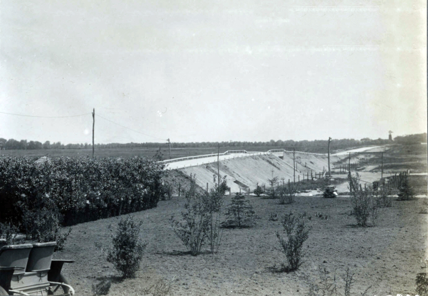
The Merrick Avenue Motor Parkway Bridge, located in Westbury/East Meadow. Rationale: The ever-present Ladenburg windmill in the background.
- Other significant structures in the Mystery Foto.
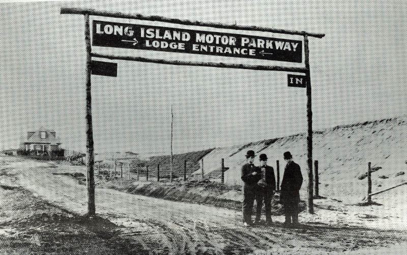
Ladenburg windmill. The Motor Parkway entrance sign seen previously only in the below image. The beginning of the entrance to the Meadow Brook Lodge.
- The approximate date of the Mystery Foto. Provide a rationale.
September 1908, prior to the opening of the Motor Parkway on October 10, 1908.
Comments (8)
Congrats to Joe Osterle, David Miller, Art Kleiner, Steve Lucas, Brian McCarthy and Frank Femenias for identifying the Merrick Avenue Motor Parkway Bridge.
Kudos to Brian McCarthy for supporting his Comment with jpegs.
Enjoy,
Howard Kroplick
Close-Ups
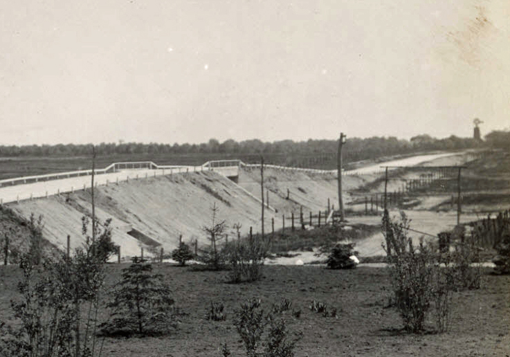

View looking west
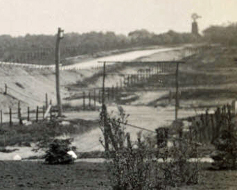
This is an opposite view looking east. Note the sing tower that can seen in the Mystery Foto.


Comments
I say Merrick Ave. photographer is just south of the LIMP. The Meadowbrook Lodge is to his or her left. The entrance for the LIMP to Merrick Ave is just right of the photo. The windmill/tower is the giveaway.
One thing I never knew about the Merrick Rd bridge was the presence of a culvert under the west approach.
This is the south side of the LIMP facing east, just west of Merrick ave. A newly constructed bridge carrying the LIMP over Merrick ave can be seen in the center of the photograph. In the distance to the right is the Ladenburg windmill. Below that, in the foreground to the right is the archway over the entrance to the LIMP at what would be the Meadowbrook lodge. The photographer is probably pretty much standing on the site of the lodge building facing east. The sign is not finished and the entrance ramp is also not completed dating this photo probably just before the parkway opened in October of 1908.
Merrick Avenue Motor Parkway Bridge, East Meadow, looking east. Willie K. himself as photographer?
The Ladenburg windmill. And a culvert in the foreground of the bridge. Also is it my imagination or is that the posts of the soon to be sign identifying the Meadow Brook toll house on the right side of the photo. Just the posts, without the sign actually installed yet.
October, 1908.
I’m not overly confident this week but I think we’re looking east with the Merrick Avenue bridge in the center because of the Ladenburg windmill in the distance. I think the photographer was set up on the property of the Meadowbrook Lodge. Could that be the tip of the peak of the lodge almost entirely hidden by the trees and bushes? Other structures include the Newbridge Avenue (Bellmore Road) bridge in the distance. Also, I think I see the structure awaiting the LIMP entrance sign on the west side of Merrick Avenue. There is also a drainage culvert under the LIMP and what appears to be a delivery vehicle for the shrubs. Since the quantity of shrubs appear to be awaiting placement elsewhere on the LIMP, I think the date could be around September, 1908 just before the opening of the parkway the following month.
Just a guess, but is this where the sand pits are now, and where the bridge abutment supports some sand-and-gravel machinery?
Excellent find, Greg! This photo was taken at the Meadowbrook Lodge property, to the northeast. In sight is the LIMP bridge over Merrick, the frame for the lodge entrance sign ( no sign is seen, and the windmill on the Ladenburg property in the distance. As far as a photo date, 1915. No later than 1920. Cedar posts are seen, believed they were replaced with concrete posts post 1920.
Great photo Greg, haven’t seen this one before. Photo was taken from the backyard of the Meadow Brook Lodge (1908-1960s) looking east at the Merrick Ave bridge (1908-1940s) and the Ladenburgh windmill in the distance. The lodge’s entrance/exit ramp from/to Merrick Ave is just off the photo to the right. The flatlands east of the bridge looks similar today where the Eisenhower Park’s Red Golf Course resides. It looks like the Motor Pkwy is still open for business so photo was snapped sometime before its closing in 1938. Toll keepers Otto McCamish and wife Pernelle continued living in the lodge until early 1960s
Greg, Regarding the culvert… that was built for the Meadowbrook Creek which had it’s origins some where north of the Parkway and at a substantial cost since it was about 60 feet long. Which leads to the question- was a culvert also built under the entrance/exit ramp ? (and Stewart Ave. which was built about 1905-07.) The creek bed ROW is still defined behind the buildings south of the entrance/exit ramp.
Steve, That’s not a shrub delivery vehicle, thats me in a golf cart. I hit a big wild hook of the tee of the 17th hole on the Red course that morning.
Al & anyone else interested - After looking at a few aerials on Howard’s site here, there appears to also had been a culvert beneath the entrance rd to the lodge. I screenshot & marked maps below. The reservoir in Eisenhower Park was much smaller prior to the construction of the Meadowbrook Pkwy ( seen on the 1947 topo map ) Actually quite a few streams evident north into the park back then.
Brian, Here’s a 1925 postcard from my collection looking east from Merrick Avenue into what would become Nassau Co. / Salisbury / Eisenhower Park showing the original, probably manmade lake.
Nice find Brian. Merrick Ave must’ve had a drainage culvert as well for the stream’s NE direction.
In Gary’s photo, I didn’t know the park’s lake area was once part of the golf course. The golfers are parked adjacent to the curbs on Merrick Ave. Note the narrow tire wear in the center of the roadway to align with the narrow Merrick Ave bridge underpass up ahead!
Thanks Frank. I used to think the water source was from the south shore, but it’s the other way around. The 1947 topo map uncropped show streams north of Old Country Rd. So ground water is fed from north to the south shore.
Great postcard Gary! I can see there used to be 2 culverts on the north side for water flow below the railroad tracks that ran through the park. Today’s Veterans Memorial would be just east of the reservoir, and the roadway on the north side follows the RR ROW. Know I read somewhere the reservoir is man made, probably to contain the streams. And there’s the other large pond nearby the Meadowbrook Pkwy.
I like the name, “Salisbury Plains”.