Updated: Mystery Foto #14 Solved: The Northern State Parkway Under Construction in 1932

Kleiner's Korner (Art Kleiner) challenged you to solve this Mystery Foto aerial.
Mystery Foto questions:
- Identify the location and orientation
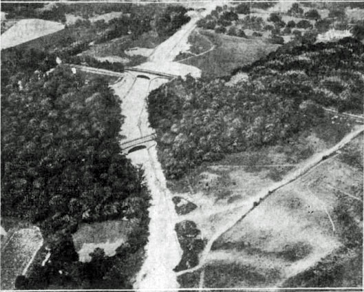
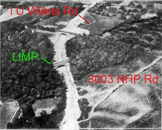
Looking east down Northern State Parkway under construction in North Hills and Manhasset Hills.
- Identify the parkways, roads and bridges
The first bridge is the Northern State Parkway Motor Parkway Bridge (East) built by Robert Moses. The bridge in the background is the New Hyde Park Road Bridge.
The parkways are the Northern State Parkway and the Long Island Motor Parkway.
- What date was the Mystery Foto taken? Provide a rationale.
The photo was published in the July 31, 1932 issue of the Brooklyn Daily Eagle.
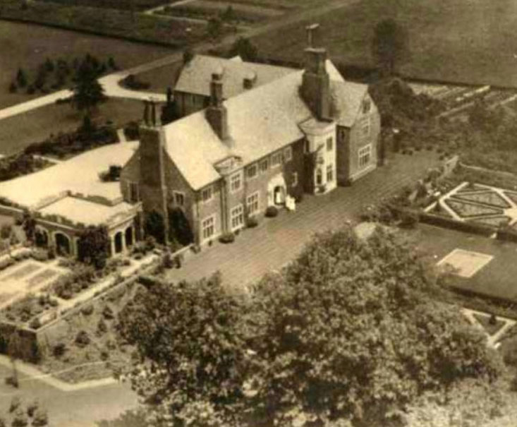
- Who was the owner of the estate located in the right corner of the aerial?
This was the 44-acre estate of Lawrence Hobart Shearman, a vice-president of the W.R.Grace & Co. Built in 1918, this 22-room mansion called Northcourt was desgned by architect J.W.O'Connor.
- What is the current use of the building?
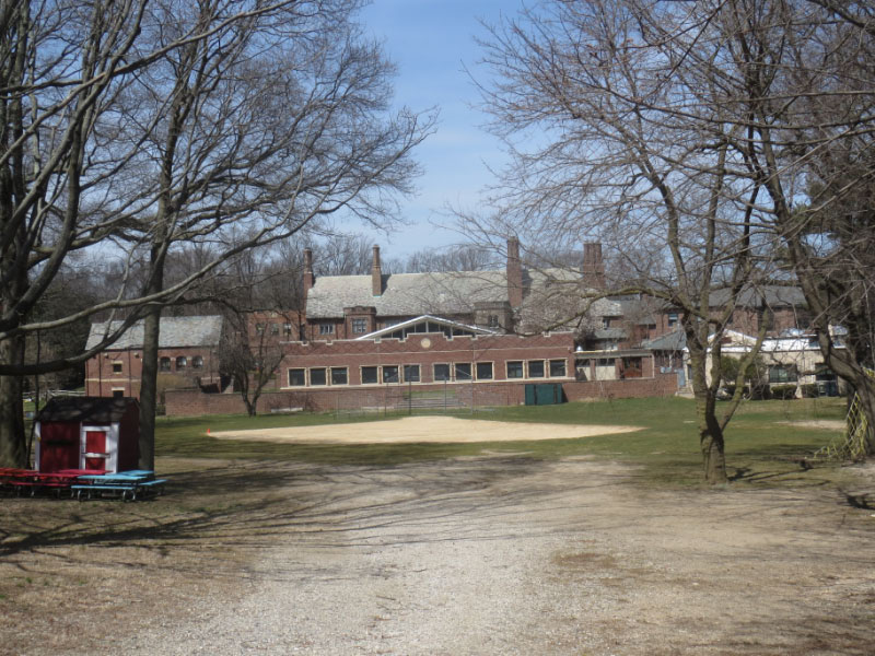
In 1995, the mansion and property (now 19 acres) was purchased by the still very much operating Buckley Country Day School.
- Which 2003 hit movie was filmed in this building?
Jack Black's School of Rock was partially filmed in the school. Scenes in the cafeteria, faculty rooms and Rosalie Mullins' office were shot during the Christmas holiday break at Buckley.
Comments (8)
Congrats to Joe Oesterle, Greg O., Tim Ivers, Steve Lucas, and Frank Mendyk for identfying the Northern State Parkway near New Hyde Park Road.
Kudos to Greg O., Tim Ivers, Steve Lucas and Frank Mendyk for recognizing the former Shearman estate, the current home of the Buckley Country Day School and the location site for scenes of School of Rock film.
Enjoy,
Howard Kroplick
Brooklyn Daily Eagle July 31,1932
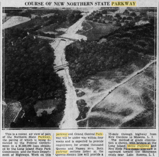
"This is a recent air-view of part of the Northern State Parkway, the paving of which is being financed by the Federal Government in a $1,500,000 loan...The method of grade elimination is shown, with bridges at the Long Island Motor Parkway and New Hyde Park Road, the view is eastward toward the Shearman estate near Lake Success, L.I.".
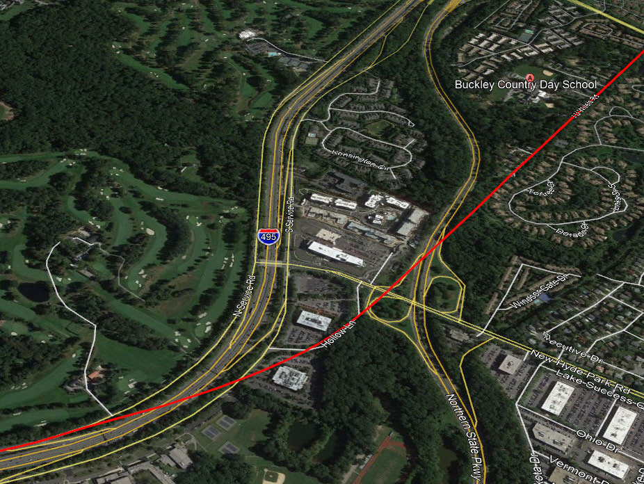
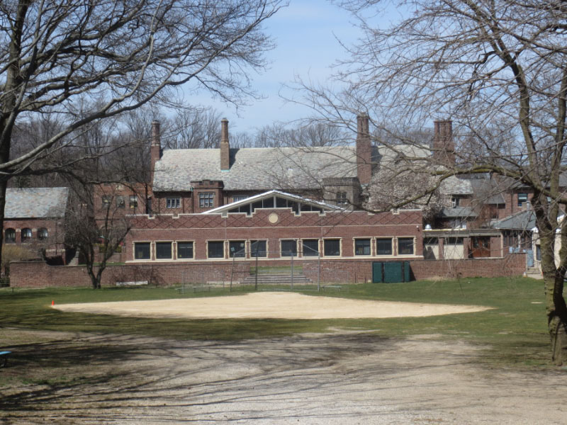
Current View
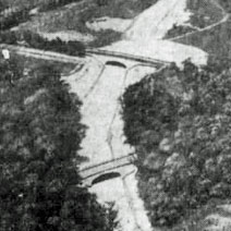
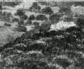
Close-Ups
"School of Rock" Preview
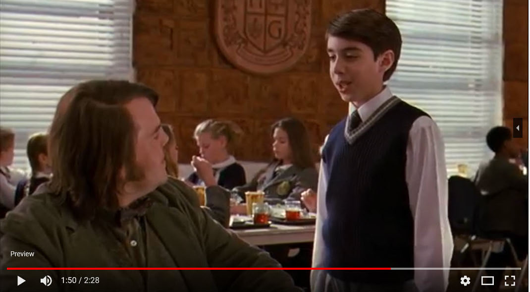
The Buckley Country Day School's cafeteria makes an appearance at 1:50.
Mendyk's Discoveries (Submitted by Frank Mendyk
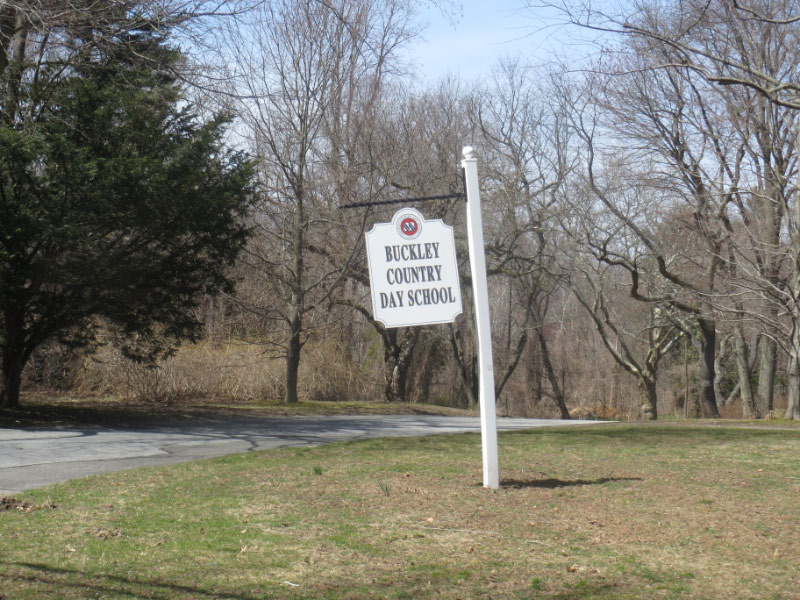
Buckley Country Day School taken today 4-09-18
Femenias' Findings (Submitted by Frank Femenias)


Comments
NSP. Looking east over the LIMP bridge built by Robert Moses, and New Hyde Park Rd further behind it.
-Identify the location and orientation
Looking Easterly at Northern State Parkway construction in New Hyde Park
-Identify the parkways, roads and bridges
The upper bridge is the New Hyde Park road bridge over the new NSP. The lower bridge is the Moses constructed Motor Parkway bridge
-What date was the Mystery Foto taken? Provide a rationale.
The bridges were constructed in 1931- so that would be a safe guess on the photo’s date.
-Who was the owner of the estate located in the right corner of the aerial?
“Northcourt” in North Hills, built in 1918 for Lawrence Hobart Shearman Esq., Vice President at W.R. Grace by architect James O’Connor.
-What is the current use of the building?
Since 1955, it has been Buckley Country Day School
-Which 2003 hit movie was filmed in this building?
School of Rock starring Jack Black
This is Lakeville Road & Marcus Avenue in Lake Success. The House is the Deepdale Vanderbilt Estate in Lake Success.One of the bridges is the Limp farm bridge over the Northern State Parkway. Great stuff. Thanks,Gene Perry
Looking west at the 1931 construction of Northern State Parkway with the two bridges at New Hyde Park Road in the forefront. The North Hills estate, “Northcort” is in upper right, presently the Buckley Country Day School, where scenes from the 2003 movie “The School of Rock” were filmed.
We are looking east over the Northern State Parkway in North Hills (North New Hyde Park). The two bridges are New Hyde Park Road (upper) and LIMP (center). I think that’s Marcus Avenue angling off to the right. Since this section of the NSP opened on July 15, 1933, this photo was probably taken in 1932. I believe the estate was owned by Isaac Underhill Willets although one source mentioned the Shearson family???. Since 1955, the estate has been part of the campus of the Buckley Country Day School. Some scenes from the movie “The School of Rock”, starring Jack Black, Mike White, and Joan Cusack were filmed there.
Looks like Northern State going under new bridges at Lakeville Road and New Hyde Park Road, ca 1928—The building was one of Willie K’s I believe, but don’t know the movie.
Most likely incorrect but here goes. Lake Success with Deepdale on top right, looking SW over the NSP with Lakeville Rd bridge and Moses’ 2nd Motor Parkway bridge over New Hyde Park Rd. Moses’ 1st bridge over NSP still to be built.
The location of the photo is the Northern State Parkway being constructed in New Hyde Park, Manhasset Hills, and North Hills. The photo is facing towards the northeast.
The Northern State Parkway(under construction), New Hyde Park Rd, I.U. Willets Rd and the LIMP. The 2 bridges are for New Hyde Park Rd and the LIMP.
The date of the photo I would say is in the early to mid part of 1932. The parkway ground breaking was in March of 1931 and it opened to traffic on 6/15/33.
The estate property mentioned was originally that of Isaac Underhill Willets(I.U. Willets. The estate building and property at the time of the photo was owned by L.H. Sherman. He was a prominent lawyer and the first mayor of the Village of North hills when it was incorporated in September of 1929.
The buildings and surrounding property is now the Buckley Country Day School.
In 2003 the movie “School of Rock” was filmed in the building.
Happy to see a Mystery Foto view of my neighborhood as it appeared in 1932… but I disagree that the road on the right was either Marcus Avenue (which is located almost a 1/2 mile south of this point) or a section of I.U. Willets Road.
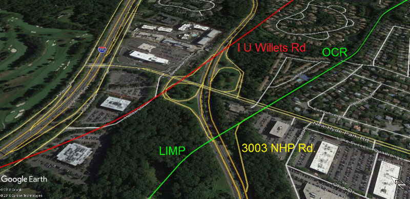
Though not distinct in the photo, and despite being obliterated by the new Parkway, the course of I.U.W. Road runs from the west (a.k.a. Hollow Lane) to the east directly between the Shearman mansion (now the Buckley School) and the golf course (now The Links condos). This can be seen on the maps ‘01’ and ‘02’ at http://sbiii.com/limpmap1.html as well as contemporary maps.
I was unable to track down any citation that the “road on the right” was a mapped, named street, and so would venture a guess that it was a trail used by construction vehicles to access the Parkway from near what is now the site of 3003 New Hyde Park Road.
Thanks, Jim
I would say the 2nd close up picture is misleading. That is not, and cannot be the Buckley School. The Buckley school is on the northern side of IU Willets Road. And in the picture, IU Willets Road is up at the top left hand corner of the picture, not even showing where the new NSP dissected it. Please take a look and let me know what you think???
-joe o.
Tricky mystery. Attached is my two cents. Awesome photo Art, keep ‘em coming
Adding to the mystery, the photo was taken in July with dense foliage, where one can’t see the Motor Pkwy east (or west) of New Hyde Park Rd heading towards the Old Courthouse Rd bridge, except the area that was cleared for 3003 NHP Rd construction.
Femenias’ Findings added to last week’s Mystery Foto.
Mystery Foto Mystery… Solved!
I can explain how geometry and dogged Googling can explain the reported confusion… stay with me!
While the Brooklyn Eagle photo captions says “the view is eastward toward the Shearman estate”, it doesn’t actually assert the estate can be seen in the cropped image; my conclusion then is the light-colored buildings in the upper right must be the old Minton estate ‘Brookwood’ property (since 1977 the site of the Gates at North Hills condo, bounded on the west by NHP Road, the north by the NSP, on east by Old Courthouse Road and on the south by the LIMP).
Maps and photos dating from 1932 through 1966 show Brookwood as having two white-walled buildings set at a right angle to each other, which can be confirmed if you zoom in massively on the Eagle photo. In contrast, the Shearman compound is more in-line and dark hued.
Today, the Gates entrance way is just steps south of the Exit 26 e.b. on-ramp, while the Buckley property is 7/10ths of a mile farther to the east, and therefore does not actually appear in the photo.
My apologies for overlooking the above when viewing Mr. Berliner’s maps; below are the site links that provided the information supporting my new understanding.
Thanks, Jim
The Mystery photo source: bklyn.newspapers.com/image/59998015/?terms=Shearman+estate
Minton estate: halfpuddinghalfsauce.blogspot.com/search?q=brookwood
Minton estate: oldlongisland.com/2011/06/brookwood.html
Shearman estate: halfpuddinghalfsauce.blogspot.com/2013/02/north-hills-estate-of-lawrence-hobart.html
Gates at North Hills entrance: google.com/maps/@40.7641196,-73.6898016,3a,75y,28.48h,84.51t/data=!3m6!1e1!3m4!1sWyXQESyM0cxZMI5LydlJDA!2e0!7i13312!8i6656
Overhead view of both properties: wikimapia.org/#lang=en&lat=40.765640&lon=-73.685110&z=16&m=b&show;=/4310801/Long-Island-Motor-Parkway-Bridge
Topographic map predating demolition of Brookwood: ngmdb.usgs.gov/img4/ht_icons/Browse/NY/NY_Sea Cliff_136118_1968_24000.jpg
Lastly, for the very patient, the Nassau County land viewer application: lrv.nassaucountyny.gov/map/ (provides current and historical maps and aerial photos plus a distance-finding tool)
Do I see a concrete wall holding up a hill on the upper left corner of the picture?