Mystery Foto #9 Possibly Solved: Powell Avenue Bridge and Nibbe Farmway Bridge in Bethpage?
Last Friday Frank Femenias submitted this mystery photo that has been baffling me for years. After one week of comments, I believe Frank has solved the mystery. Most likely, the photographer was looking south on the Motor Parkway towards the Powell Avenue Bridge and Nibbe Farmway Bridge. However, the discussion is still very much open for debate.
Here is a summary of the comments on the location of the Motor Parkway bridges::
Melville Sandpits Bridge East of Broad Hollow Road
-Mike LaBarbera
-Greg
Howard Kroplick Comment: Farmway bridge would be correct, but where is the second bridge?
Pinelawn Road Bridge/Ruland Road Bridge- Looking West
-Brian McCarthy
Howard Kroplick Comment: Both the Pinelawn Road and Ruland Road Bridges were "parkway" bridges in which the Motor Parkway was on top of the bridge...not a match with the Mystery Foto.
Ruland Road Bridge/Maxess Road Farmway Bridge- Looking West
-Brian McCarthy
-Joe Oesterle
-Joseph (motorpky) DeBono
Howard Kroplick Comment: Both bridges were close together, however the Motor Parkway went over Ruland Road...not a match with the Mystery Foto.
Little East Neck Road/Pinelawn Bridge -Looking West
-Sam Berliner III
Howard Kroplick Comment: Both the Little East Neck Road and Pinelawn Road Bridges were "parkway" bridges in which the Motor Parkway was on top of the bridge...not a match with the Mystery Foto.
Broad Hollow Bridge/Maxess Road Farmway Bridge- Looking East
-Tim
Howard Kroplick Comment: The Motor Parkway went over Broad Hollow Road and the trolley...not a match with the Mystery Foto.
Colonial Springs Road Bridge
-Frank Feminas
Howard Kroplick Comment: The Motor Parkway went over Colonial Springs Road and second bridge is missing...not a match with the Mystery Foto.
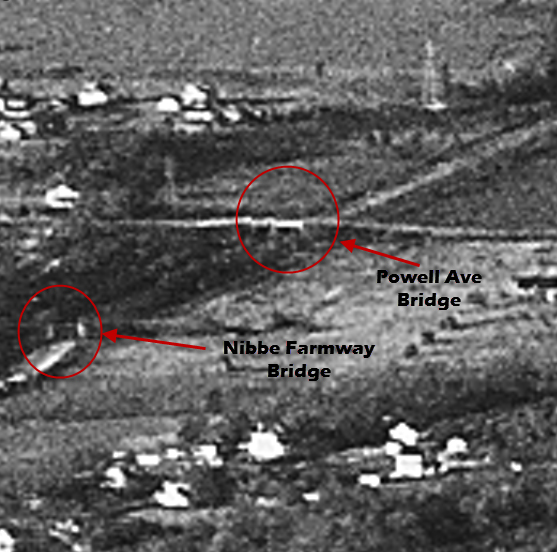
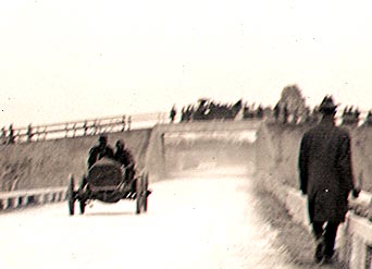
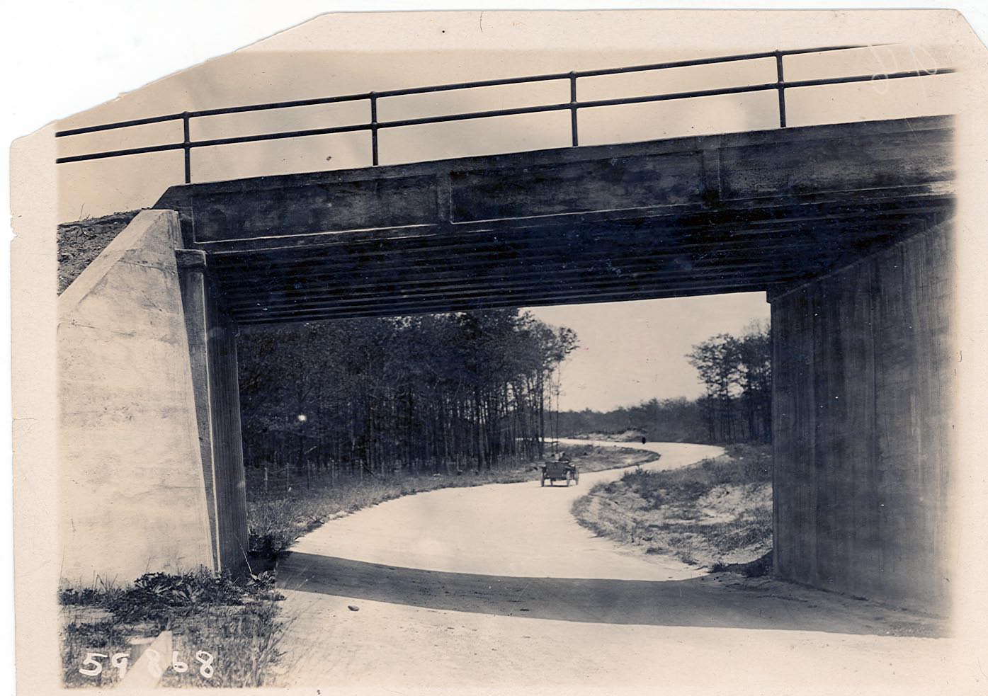
Powell Avenue Bridge/Nibbe Farmway Bridge- Looking South
-Frank Feminas
Howard Kroplick Comment: This may be the solution to the Mystery Foto!! The Motor Parkway went "through" both bridges which were close together. Best evidence is the rare 1908 Sweepstakes photo looking south from the Powell Avenue Bridge. Look through the bridge and you can see the Nibbe Farmway bridge!! Also note the matching guardrails.

Enjoy,
Howard Kroplick
Update: 4/14/2013
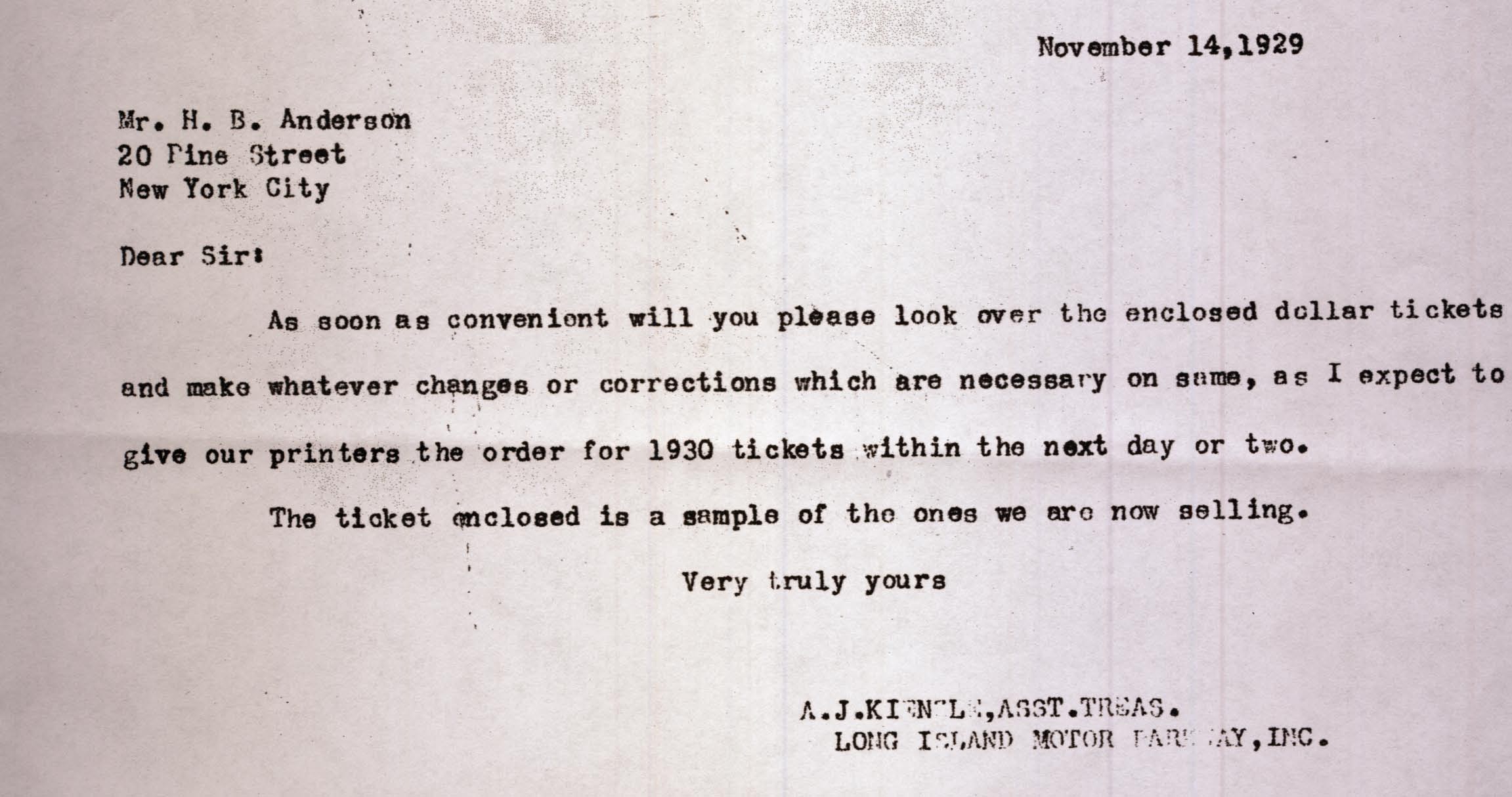
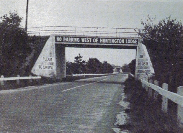
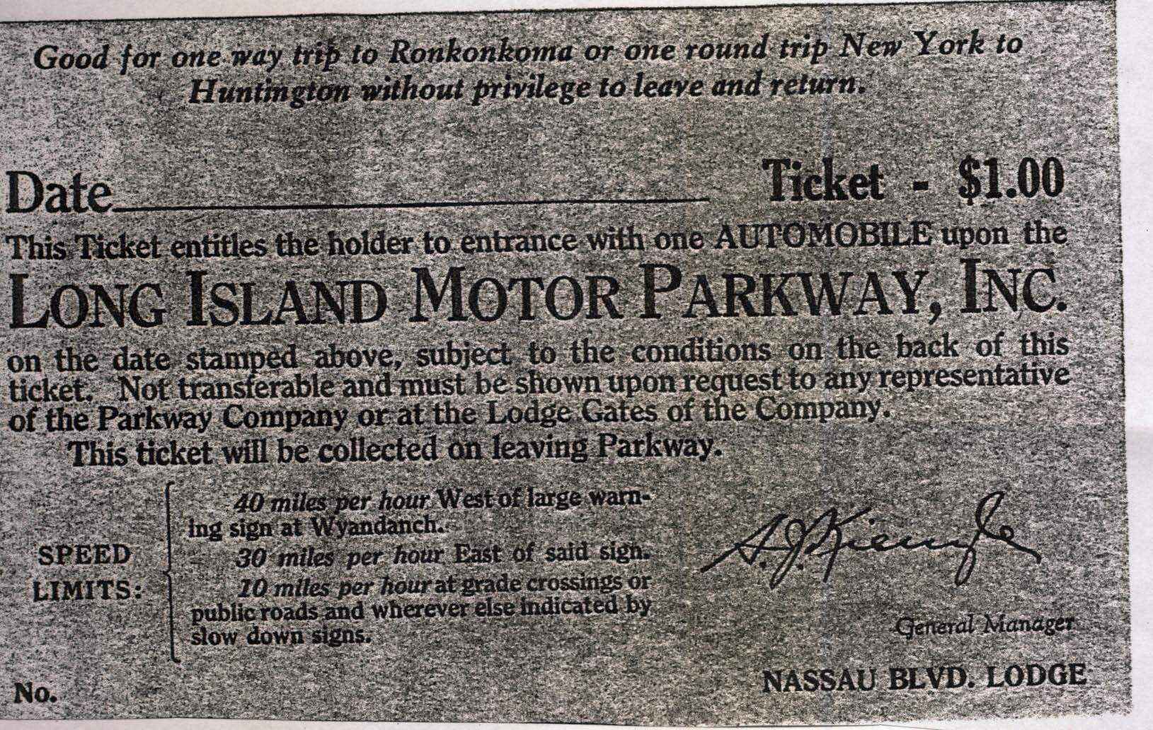
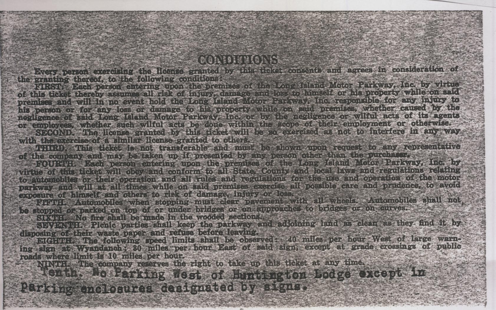
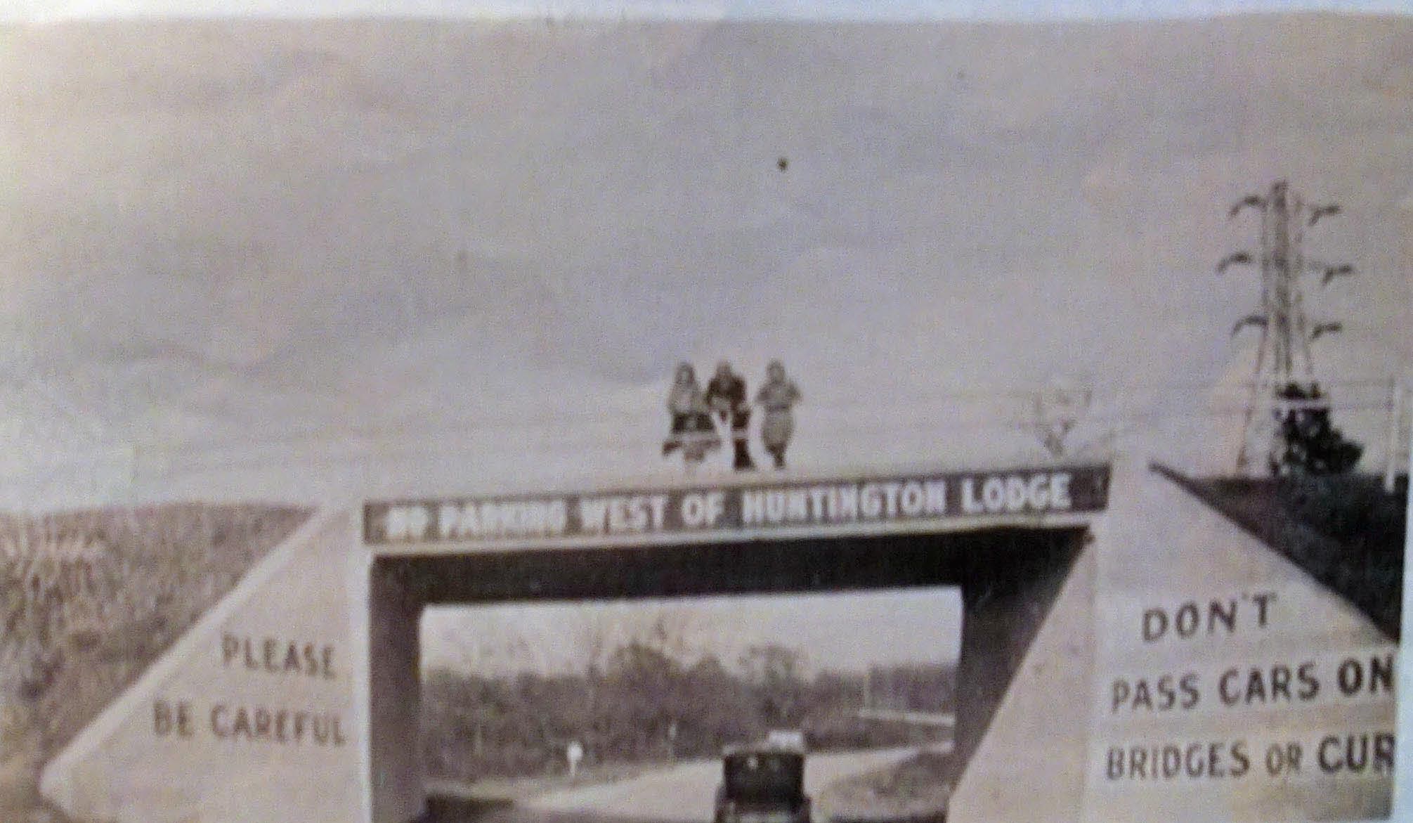
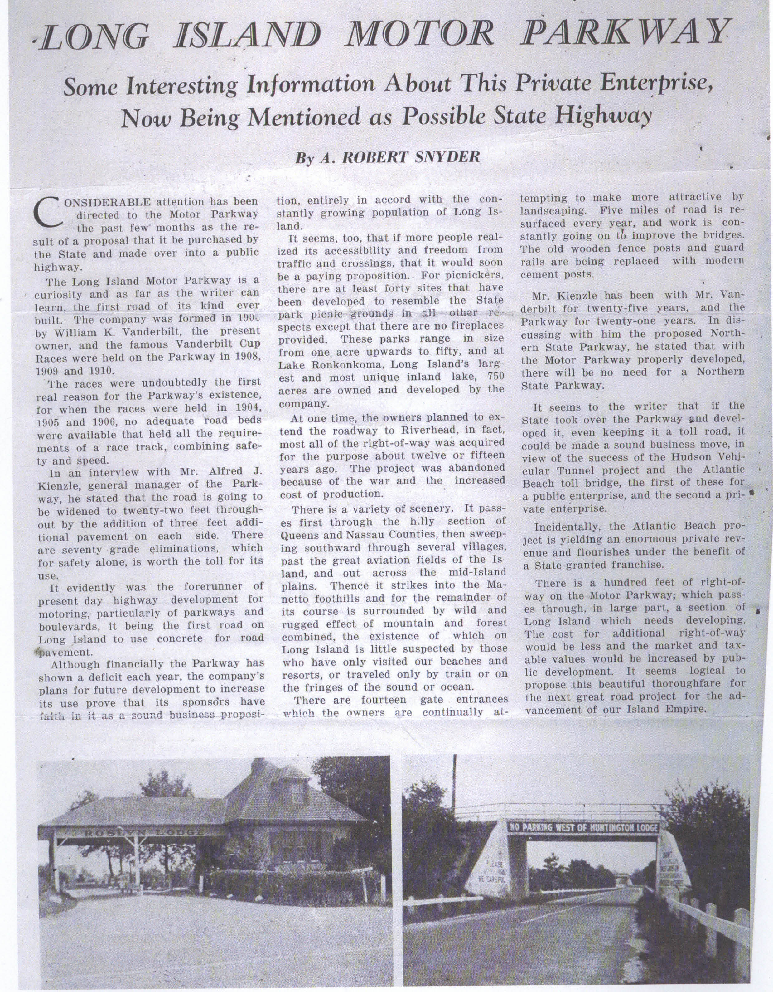
My favorite co-author Al Velocci has provided this November 14, 1929 Motor Parkway letter form Assistant Treasurer A.J. Kienzle courtesy of the Suffolk County Vanderbilt Museum. The letter requests a change to the 1930 Motor Parkway $1.00 tickets adding the following line: "Tenth. No Parking West of Huntington Lodge except in Parking enclosures designated by signs."
Apparently, an incident occurred that resulted in placing the warning on the tickets and bridges from Bethpage to current Melville.
One possibility: If it was important enough to place the warning on all the 1930 tickets, Kienzle may have placed the warning on both sides of bridges in the area.
New Clues: April 8, 2013
Assumptions
We are looking at two bridges in which the Motor Parkway went underneath the bridge. Accordingly, the two bridges would be categorized as a "highway" bridge or a "farmway" bridge rather than a "parkway" bridge (Motor Parkway went over the intersecting road).
The bridges were located somewhere near the Huntington Lodge located east of Broad Hollow Road (Route 110) in current Melville.
Classification of Bridges Near the Huntington Lodge
The 1928 Motor Parkway Atlas provided a description of the bridges near the Huntington Lodge in Melville. Based on the above assumptions, any bridge classified as a "parkway" bridge can be eliminated from consideration.
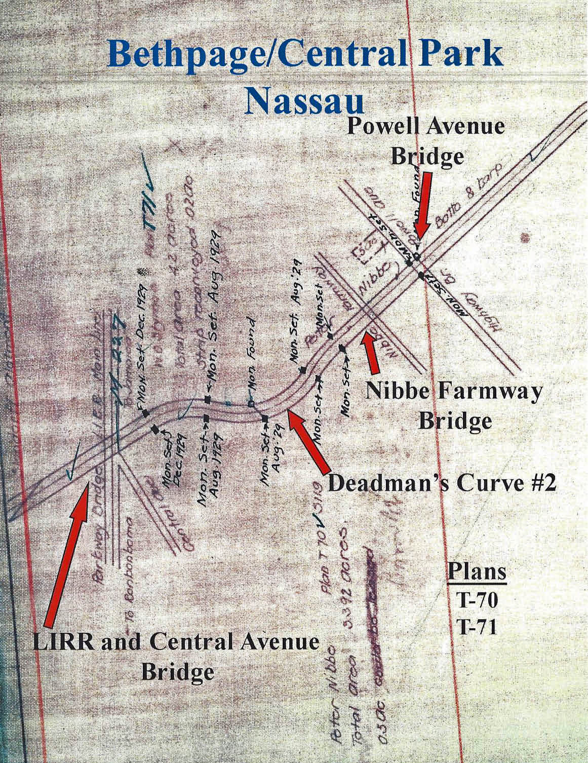
Central Avenue Bridge: Parkway Bridge
Nibbe Bridge: Farmway Bridge
Powell Avenue Bridge: Parkway Bridge
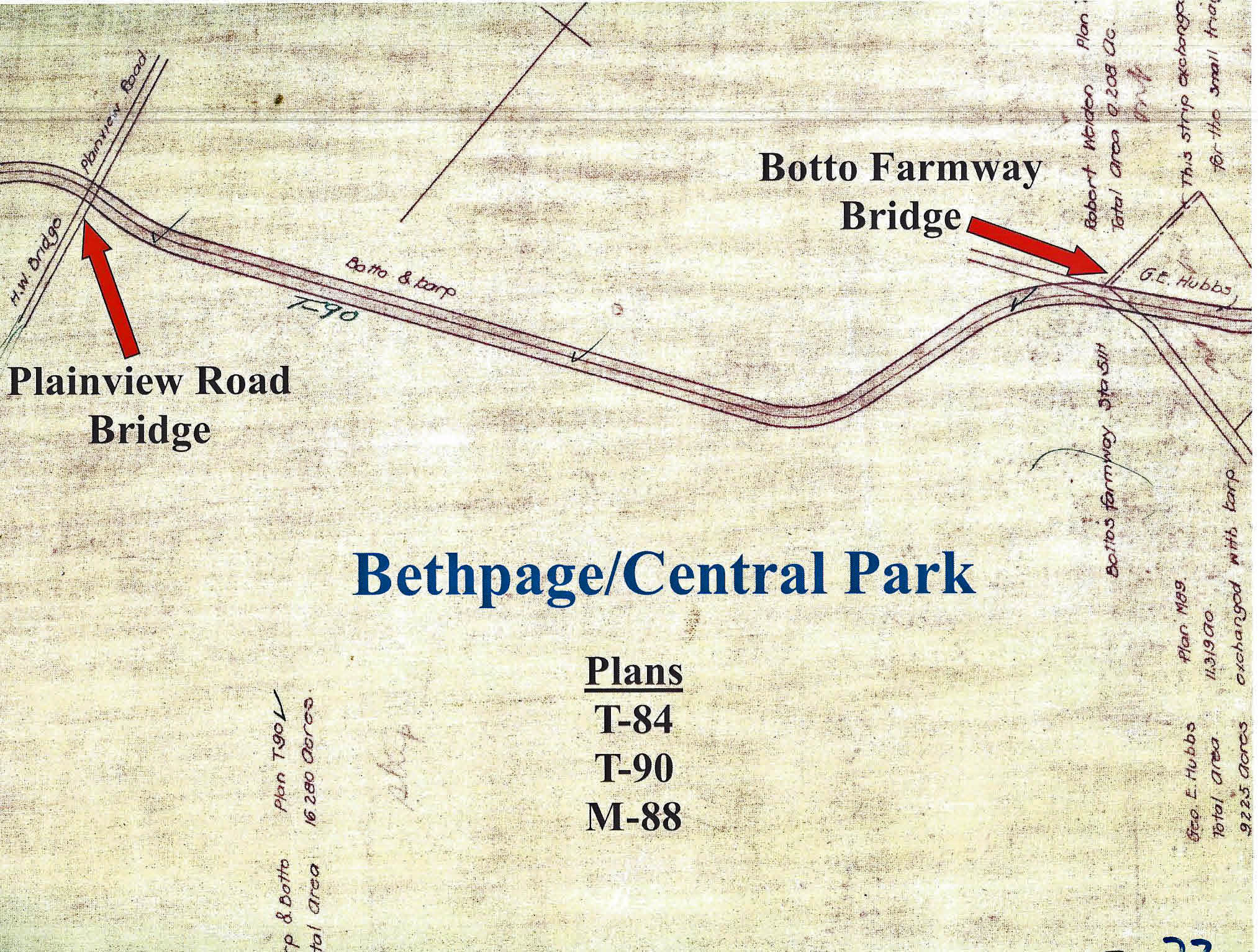
Plainview Road Bridge: Parkway Bridge
Botto Bridge: Farmway Bridge
Round Swamp Road Bridge: Parkway Bridge
Claremont Road Bridge: Parkway Bridge
Old Bethpage Bridge: Parkway Bridge- Note correct classification
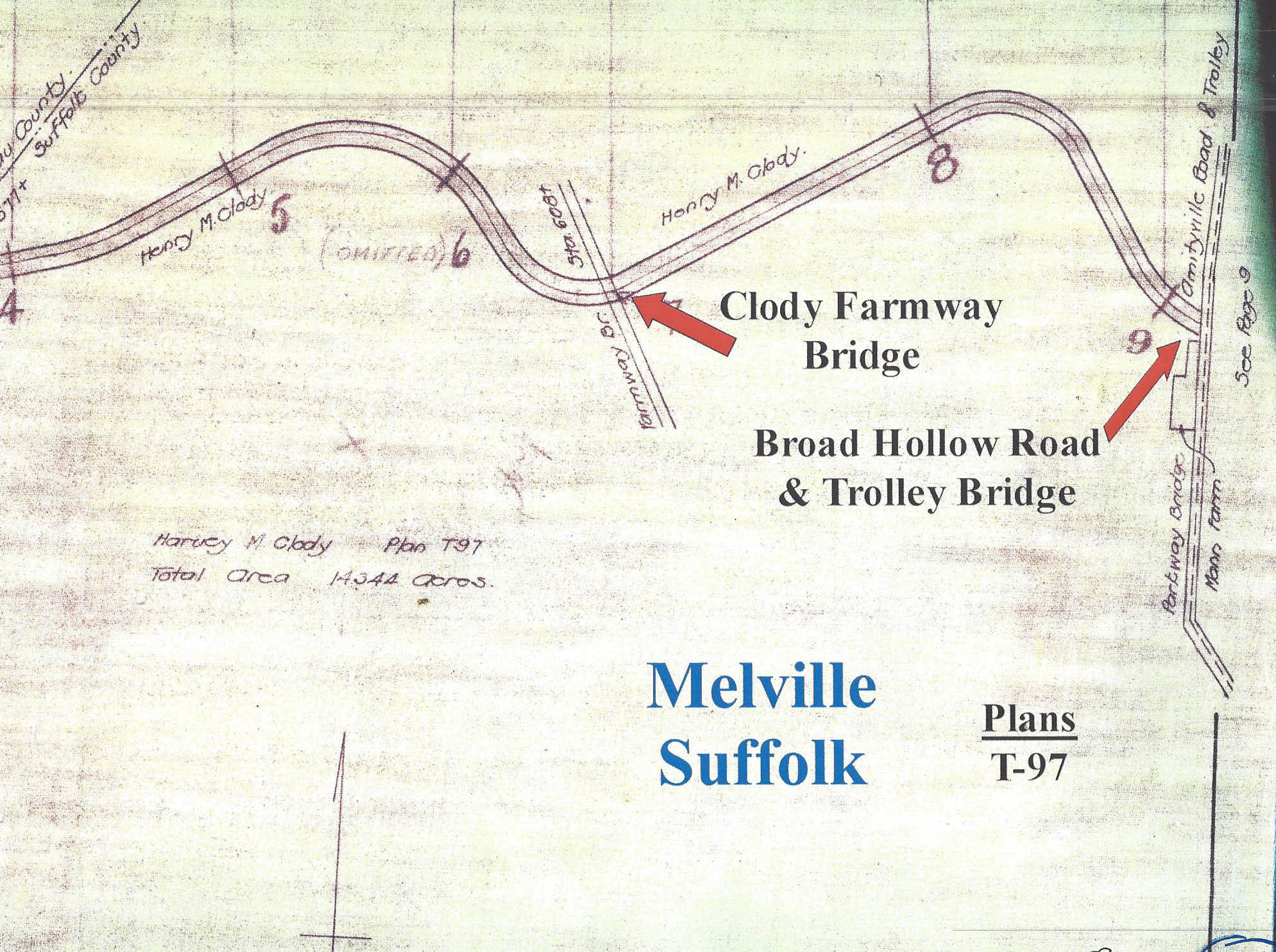
Clody Bridge (Melville Sandpits): Farmway Bridge
Broad Hollow Bridge: Parkway Bridge
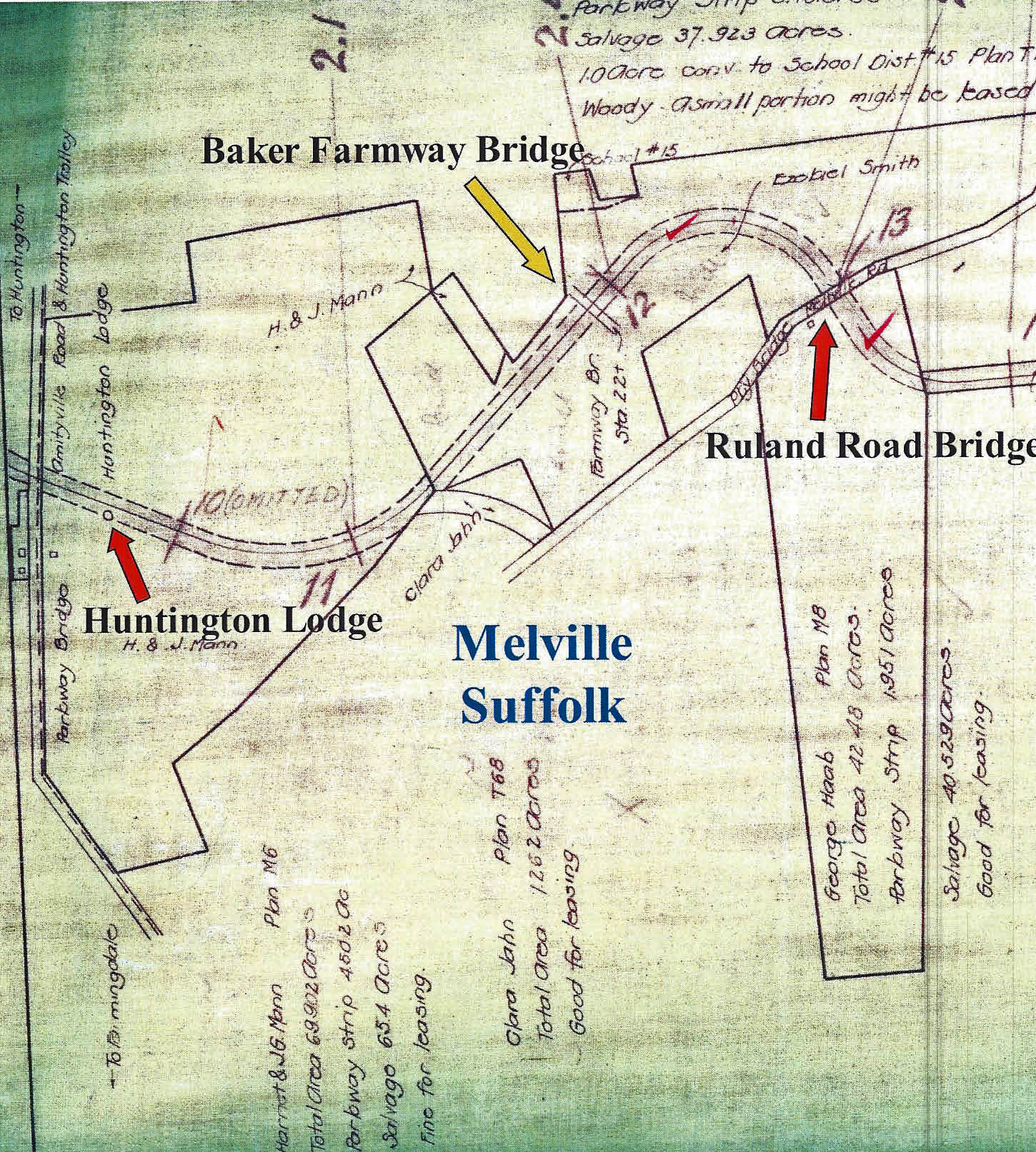
Baker Bridge (Maxess Road): Farmway Bridge
Ruland Road Bridge: Parkway Bridge
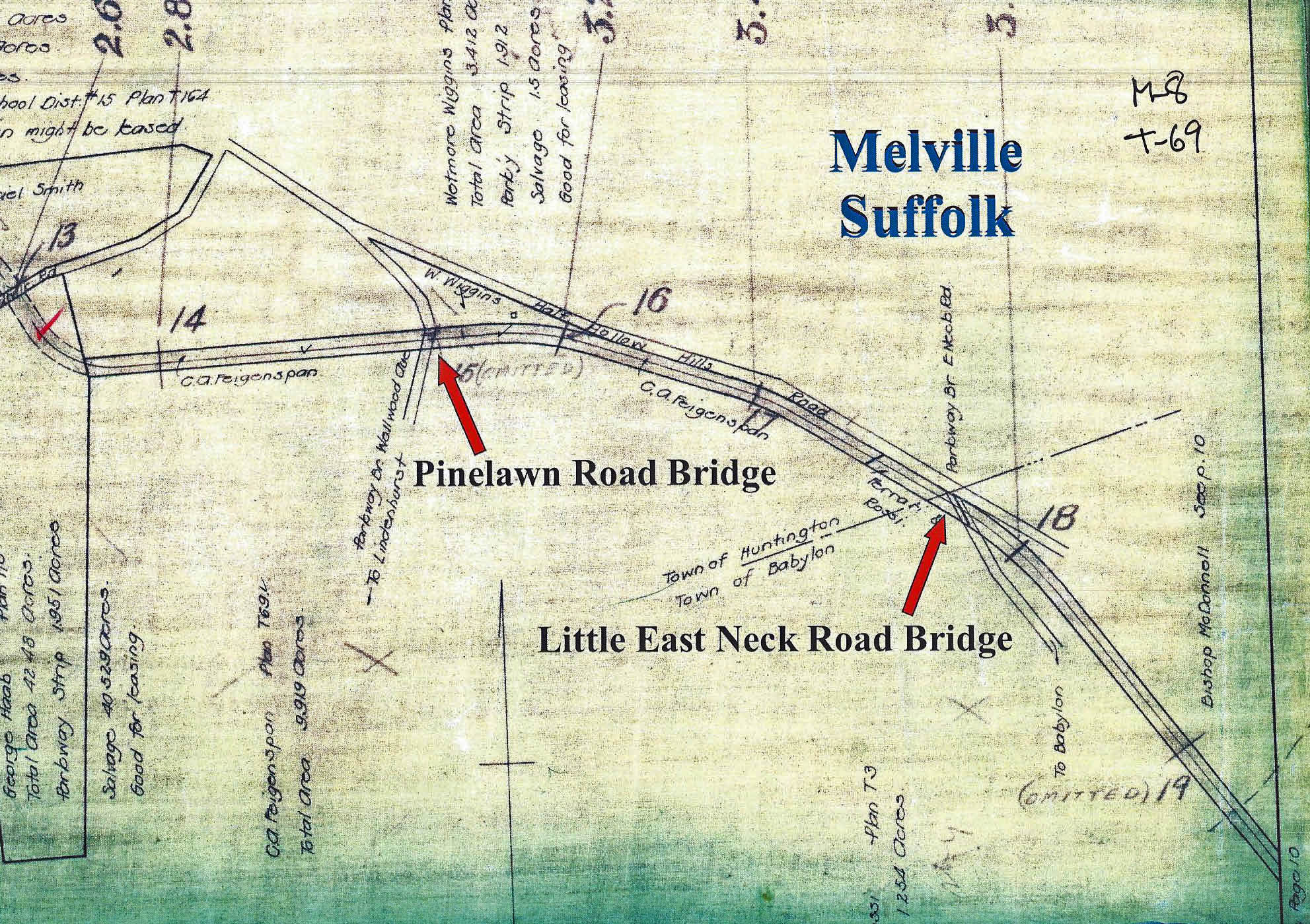
Pinelawn Road Bridge: Parkway Bridge
Little East Neck Road Bridge: Parkway Bridge
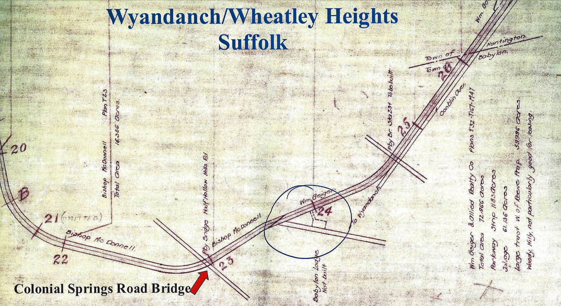
Colonial Springs Road Bridge: Parkway Bridge
Accordingly, the following bridges can be considered for the Mystery Foto: Nibbe Bridge, Powell Avenue Bridge, Plainview Avenue Bridge, Botto Bridge, Clody Bridge (Melville Sandpits), and Baker Bridge (Maxess Road),
Possible Motor Parkway Bridges
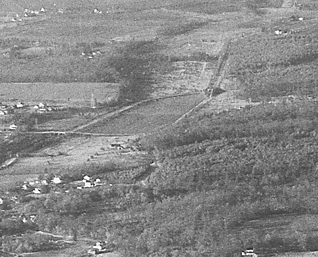
1935 Bethpage Aerial-Looking North
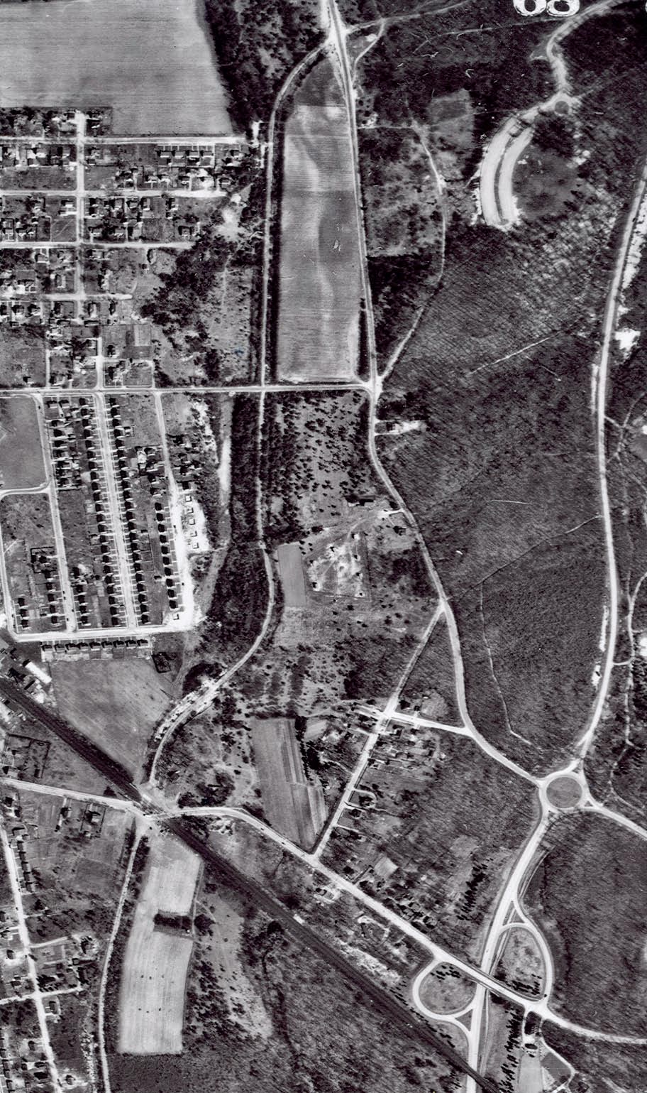
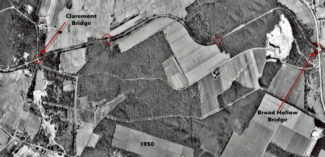
1950 Bethpage Aerial
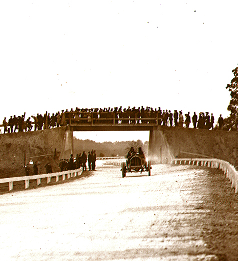
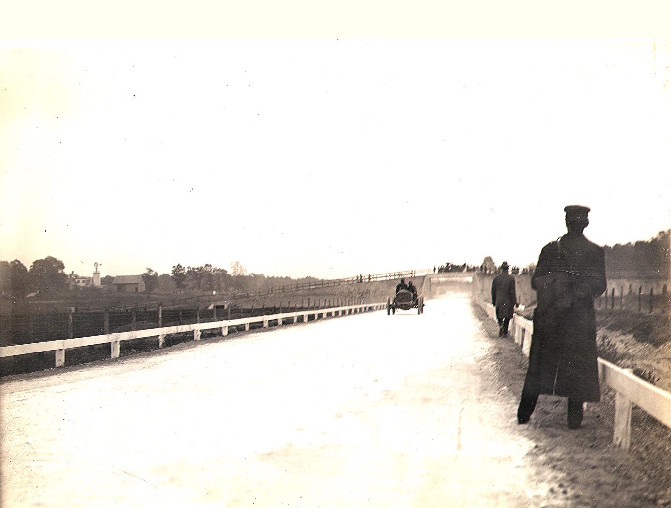
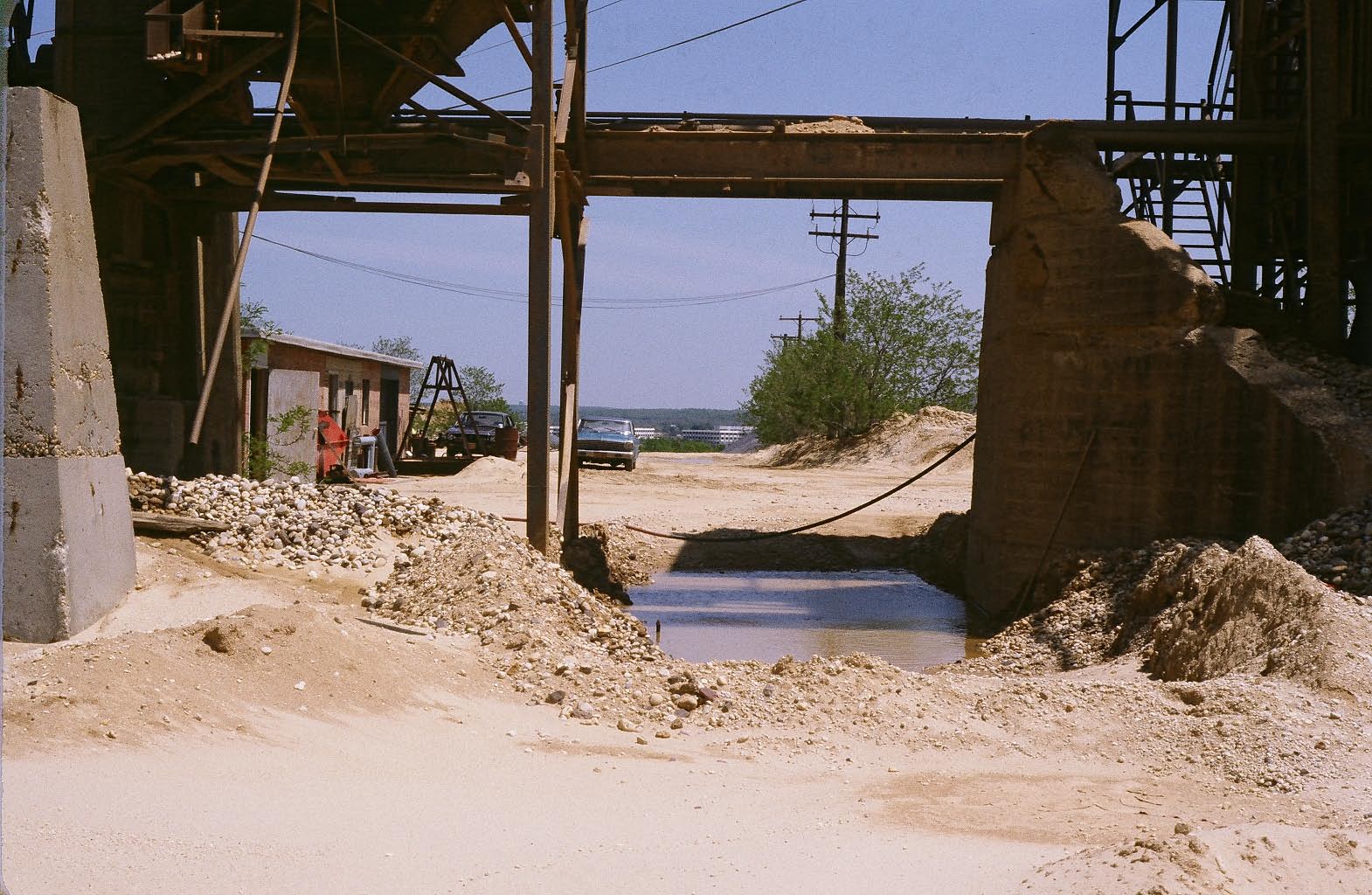
Nibbe Farmway Bridge-Looking South (1908)
Nibbe Farmway Bridge- Lokking Northwest (1908)
Powell Avenue Bridge-Looking South (1908)
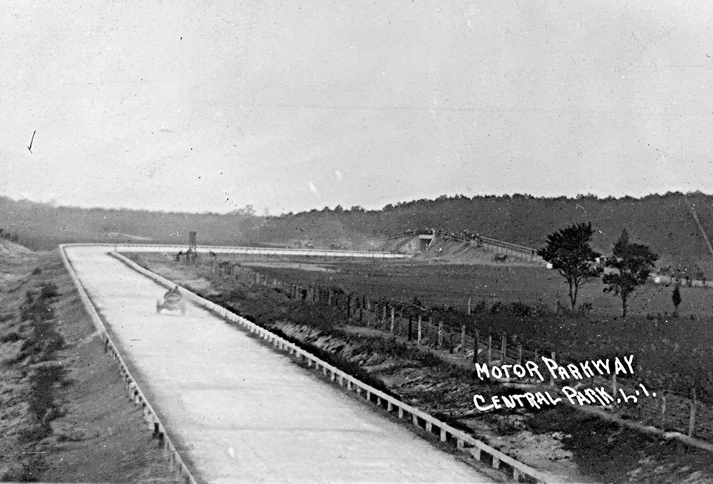
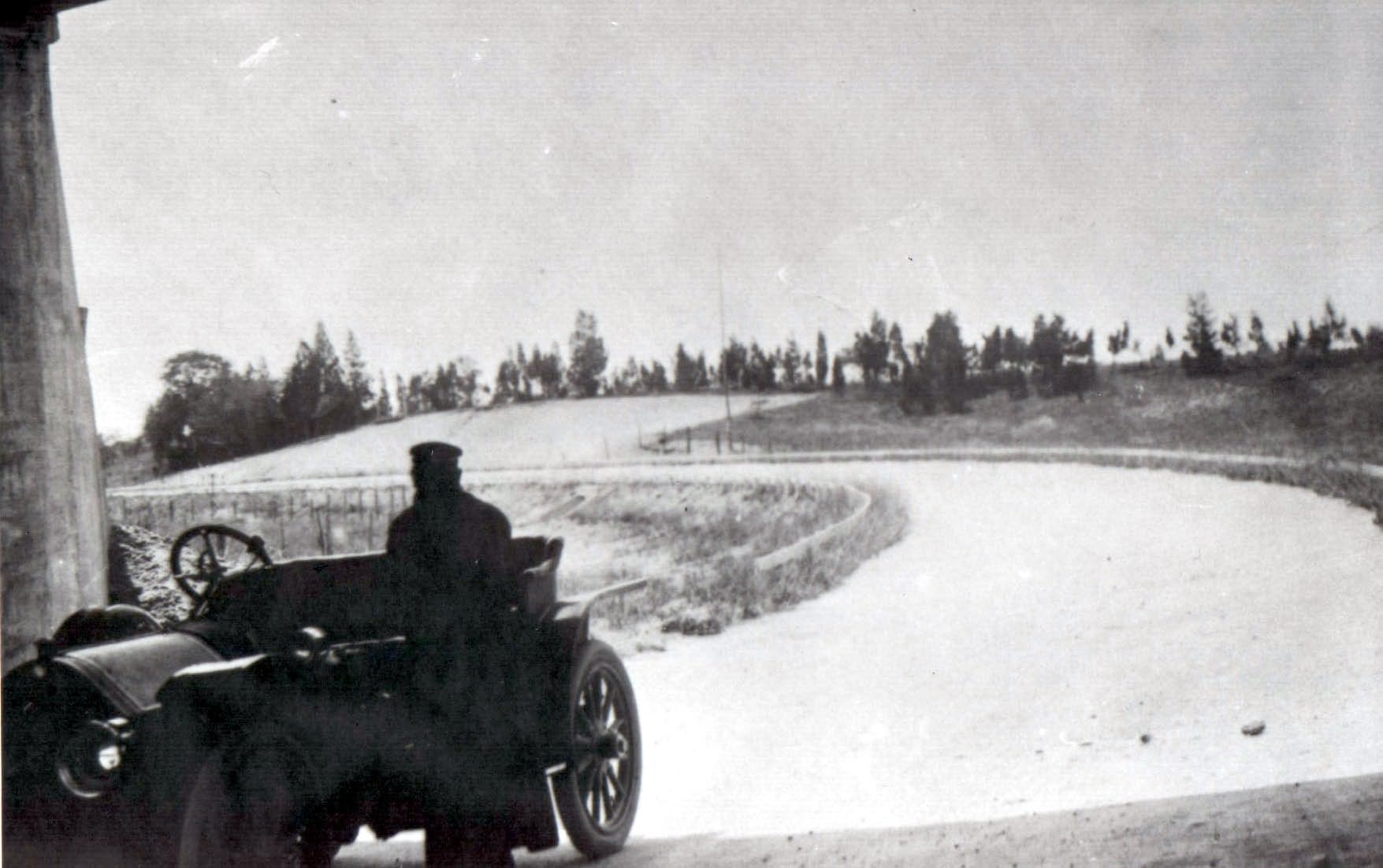
View from Powell Avenue Bridge -Looking North to Plainview Road Bridge (1908)
1935 Bethpage Aerial- Looking North
Plainview Road Bridge- Looking East (Courtesy of Aline Scherer)
Plainview Road Bridge- Looking East
Plainview Road Bridge- Looking West
View from Plainview Road Bridge- Looking Southwest (1908)
Botto Farmway Bridge (Courtesy of Ron Ridolph)
Botto Farmway Bridge (Courtesy of Ron Ridolph)
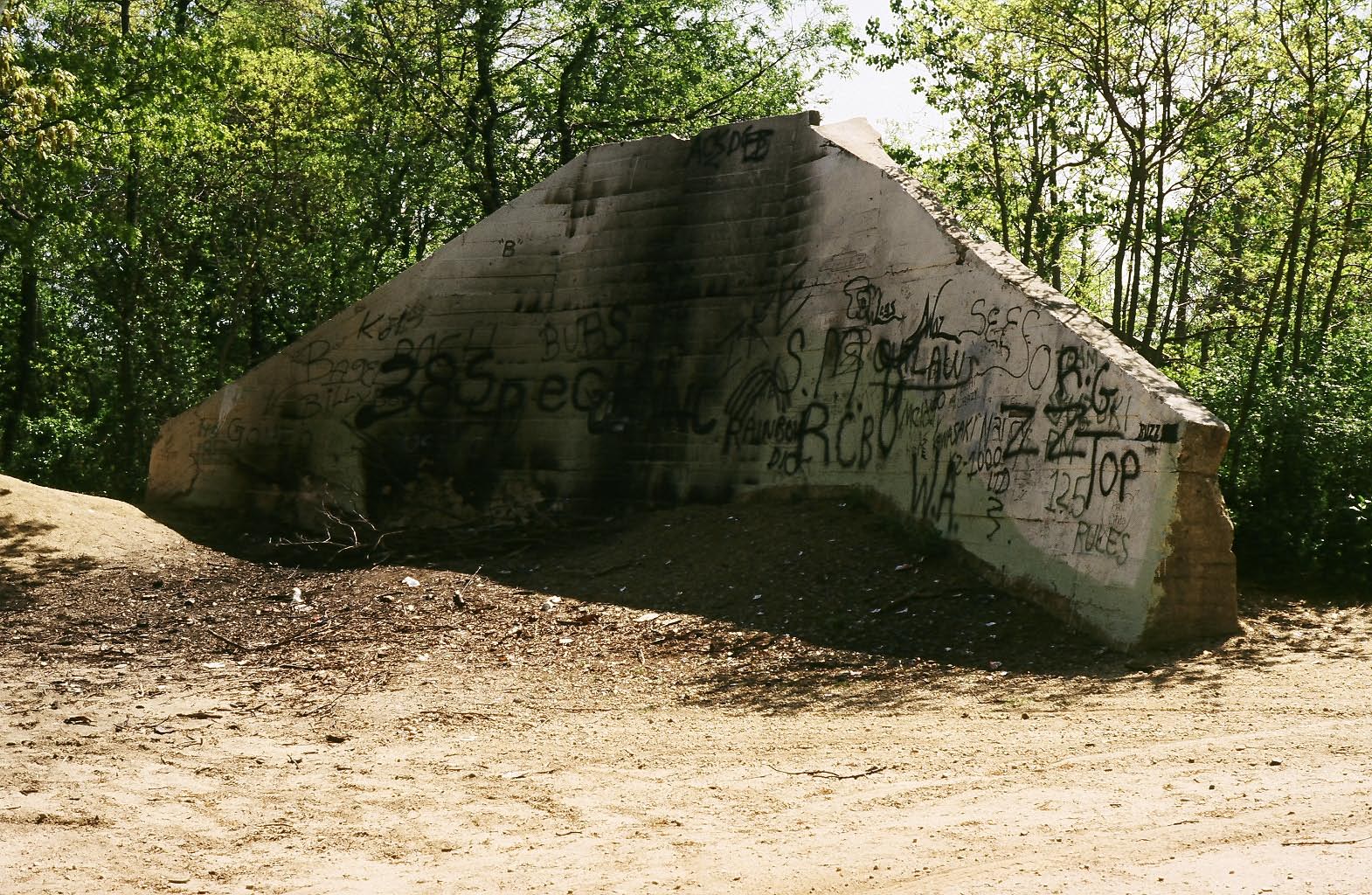
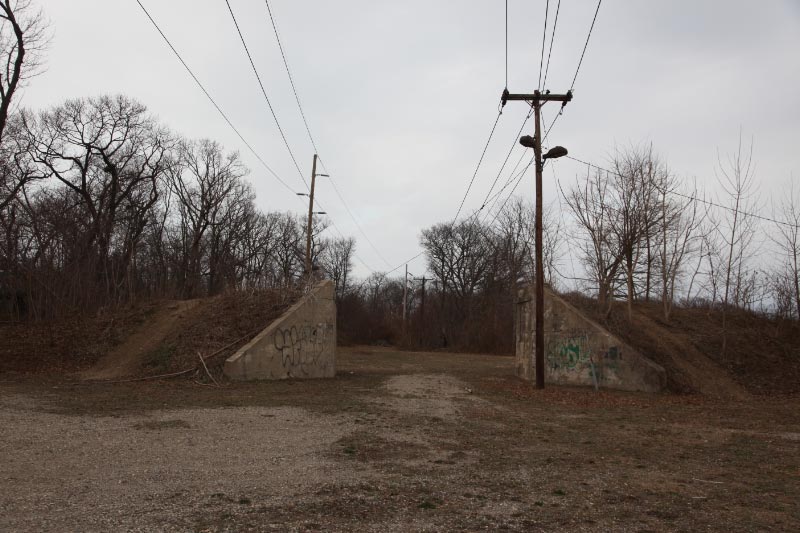
Clody Bridge (Melville Sandpits): Looking West (Courtesy of Ron Ridolph)
Clody Bridge (Melville Sandpits): Looking West (Courtesy of Ron Ridolph)
Clody Bridge (Melville Sandpits): Looking West (Courtesy of Ron Ridolph)
Clody Bridge (Melville Sandpits): Looking East (Courtesy of Ron Ridolph)
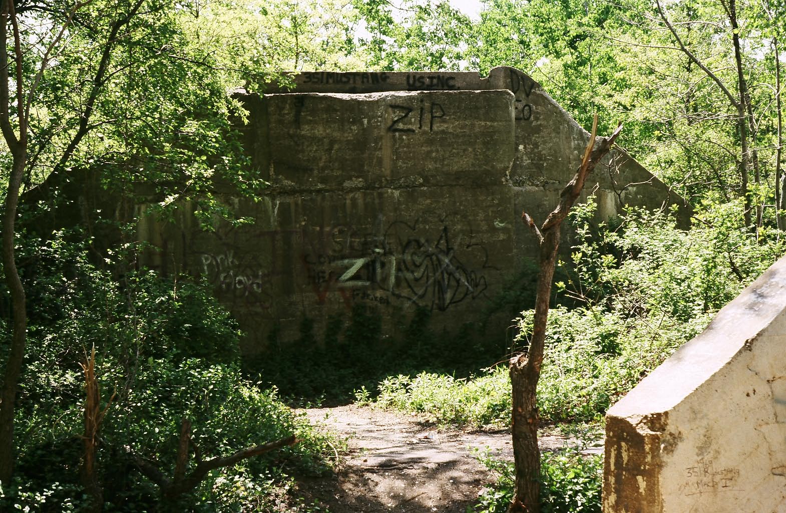
Baker Farmway Bridge (Maxess Road): Looking East- March 31, 2013
Clues: April 4, 2013
The photo came from a 1929 Sunrise magazine article on the Motor Parkway. There was no caption with the photo.
A 1950 aerial showing the Motor Parkway and the location of its bridges west of Broad Hollow Road.
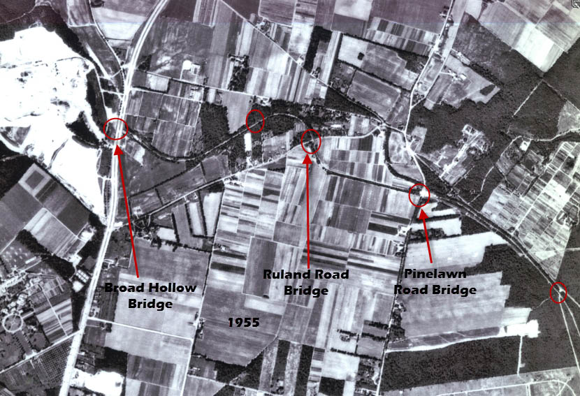
A 1955 aerial showing the Motor Parkway and te location of its bridges east of Broad Hollow Road.

A current Google Earth view of Melville. Remnants of the Motor Parkway can still be seen.


Comments
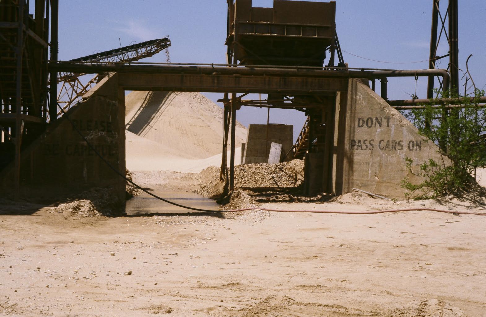
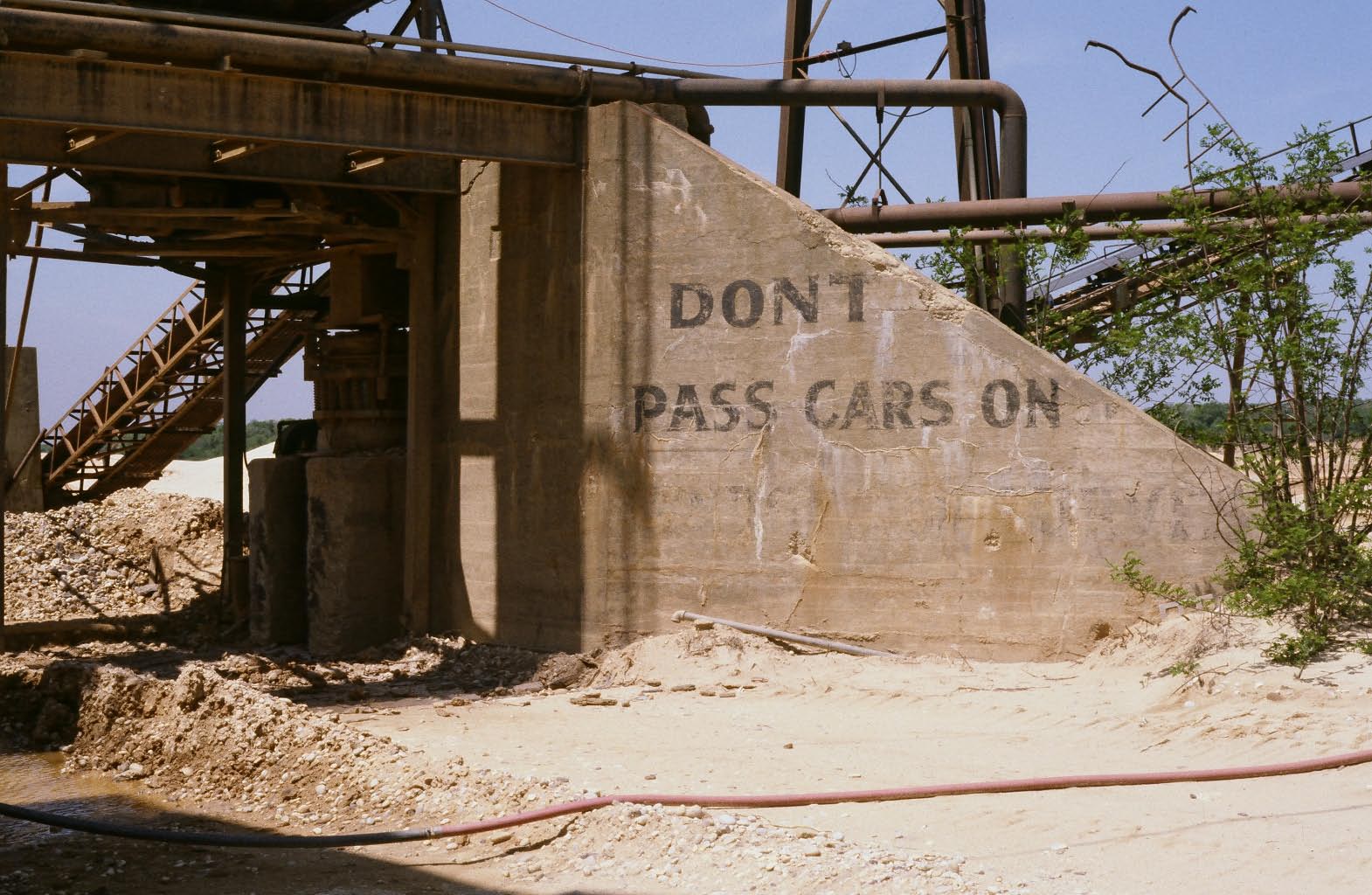
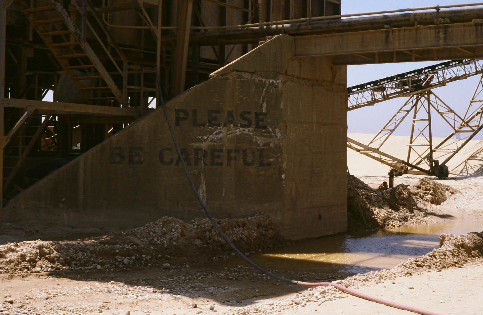
I have a feeling it is the bridge that holds up the cement mixer in Melville east of Broad hollow Road because it has the same messages on the abuttments. “Please be careful” on the left and “Dont Pass cars” on the right. Mike L
I worked at the Post Office at 110 and Duryea Rd. from when it first opened till up to 5 years ago,when I retired,so I know the area
What a nice tribute the article is to the LIMP. In this day and age, most drivers would,nt appreciate the parkways curves and turns. Oh my gosh, they would just have to slow down. Judging from the distance of the closeup bridge and the bridge in the near distance, I think the bridge with the NO PARKING. WEST. OF. HUNTINGTON. LODGE is Pinelawn Rd, and the next. bridge. west. is. Ruland Rd. The. bridges that are circled, but not named on the 1955 photo are the farmwaybridge e/o Maxess Rd, and the bridge over East Neck Rd.
The Melville sand pits bridge now being used as the hopper support? Same wording, but the lettering is a little different. It may have been re-painted at some point?
I’m taking a second guess at this. I came across some 1955 paintings by Harvey Kidder. One of the potraits is identical to the bridge overpass first seen in the above photo. So my guess is the first bridge ....NO PARKING WEST OF HUNTINGTON LODGE , is Ruland Rd over the LIMP, then the next overpass west is Farmway/Pedestrian bridge crossing the LIMP. You came up with a good one, Frank.
First off, we have to be looking west from east of Broad Hollow (110) or the parking notice would have no meaning. Next, the only place where there are two bridges close by with a gentle left curve would be the bridge where Northcote Drive is now (name?), looking west toward the Pinelawn Road Bridge. This makes the assumption that the scene is, in fact, near the Huntington lodge (it ain’t necessarily so). Sam, III
Looking east: Bridge in foreground—Rte. 110
Bridge in background—Maxess Road
If this picture is really near the Huntington Lodge, then there must be a bridge missing from your overhead view. My guess is it was between the Ruland Rd and Maxus Rd bridge.
Please Be Careful. Do Not Pass Cars On Bridges and Curves. My best guess so far is Old Courthouse Road bridge with an unidentified bridge further down (even though this is 18 mi west of the Huntington Lodge). My decision was based on those monuments that were found in the area as indicated on the 1928 Motor Pkwy Atlas. Later, new monuments were set in the same area indicating they were going to change or build something there. At N 40 45 47.2, W 73 41 02.6 I found concrete embedded in the dirt and what appears high elevation on both sides for a bridge abutment? Not sure. http://www.vanderbiltcupraces.com/images/blog/Top-1132_edited-2-1.jpg
Forget it. The west railings don’t match OCR.
From Joseph (motorpky) DeBono:
“Howard this is Joseph(motorpky)DeBono The mystery photos of the two bridges are. The first one, Ruland rd The next one is a foot bridge ( a smaller bridge ) near maxess rd, near the Huntington lodge and route 110 Thanks Howard Keep up the good work, and the Chrysler is going to look great.”
My brain is so scrambled now, so I’m writing down my thoughts before typing them. NO PARKING WEST OF. HUNTINGTON. LODGE sign must have been embled on more than 1 bridge in this immediate area. It does’nt seem to matter in what direction one would be driving on the LIMP because this. very sign is posted on the. Plainview. Rd. parkway bridge photo-looking east. ( steel tower on right ). The frontal overpass in the mystery photo has this sign as well, but it’s not the Plainview. Rd overpass. On the 1928 Melville Suffolk prints, it appears than Ruland (Melville) Rd bridges over the LIMP, even though Ruland Rd is defined as a Parkway bridge. I’m too young to have a actual memory of this area when the remnants of these bridges were intact. I’m still sticking with my second guess, which would be the Ruland/Melville Rd being the first bridge over the. LIMP; and the Baker bridge in the distance.
Brian, don’t scramble your brain! However, Ruland/Melville Bridge can be ruled out since it was a “parkway” bridge that carried the Motor Parkway over the intersecting road rather than a “highway” bridge or “farmway” bridge which is shown in the Mystery Foto.
Brian, I know the feeling. I’m about to throw the towel in on this one, ha. Third guess is Powell Ave hwy bridge first, then Nibbes farmway bridge in the distance, looking south, westbound on the LIMP (where today’s Rt. 135 runs south). http://www.vanderbiltcupraces.com/images/blog/Scanned_Photo-2_editedtiff_J11.jpg The approximate distance between those two bridges would have been Approx 600ft or .11mi which coincides with the mystery photo. These two bridges would have been in view of each other. Only thing troubling is, like Sam says, the Huntington Sign doesn’t have meaning in that direction. But if you reverse direction, you lose the slight left curve at the bridge in the distance of the mystery photo. It’s possible they were warning LIMPers about parking at the lodge in both directions, while you visited Central Park. Was there back and forth golfing traffic going on in the park? Were U turns permitted on the LIMP? Be advised, “NO PARKING WEST OF HUNTINGTON LODGE”…or else. Not sure, just a theory. The Plainview Bridge sign heading towards the lodge was 3.4mi away from it and the (alleged) reversed Powell Ave sign was 3.8mi from the lodge. They were pretty close to each other in the park. The parking problem may have risen from the trolley running on Broadhollow Road. Howard, the Motor Pkwy Atlas is a great tool! Thanks for sharing.
Frank, you may be on to something here. Take a look at the 1908 Powell Avenue image looking South. Could that be the Nibbe Farmway Bridge in the distance?
Exactly Howard, that picture of Nibbes farmway bridge looking south resembles the bridge in the mystery photo that is in the distance. I have suspicion that the “no parking” signs were intended mostly for the park visitors as parking was not yet available for motorists, the car was in its infancy and parking lots were yet to be created. I’d guess they were advertising “no parking” in this open corner area of the park, right on Deadman’s #3, where the signs would be viewable from many angles and adjacent to the golf course. The Plainview bridge, being 3.4mi away from the lodge, would have been an hour’s walk to the park. But they were “illegally” parking west of the lodge, somewhere in the sand pit area, that would have made the walk to the park even shorter. This open corner area of the park, with farmland all around and no obstructions in the way, would have made the opposite facing signs at 90 degrees very visible. Just a thought. http://www.vanderbiltcupraces.com/images/blog/03-26-2008-20-00-49-552_edited-3.jpg
Confusing indeed… especially from one who lived in the area, and although a bit on in years, I still remember the LIMP as going over Ruland Rd (not the other way around), especially if at that time anyone else can recall Ruland Rd. But, if I understand correctly, the bridges—both of them, carry local roads over the LIMP; tyherefore, if it can’t be the Ruland Rd bridge, then it must be one or other on or about where Baylis, Duryea, Ruland, Pinelawn, Colonial Springs come together?
Thankyou for comforting me, Frank lol. Initially, I figured either you or Howard already knew the answer for this area. But I. guess it,s a mystery. to all. It looks like your on the right track. I’d like to think that the various farmers in the area would charge for parking around their properties. Or maybe they requested signs to be posted to plain keep cars away from their fields.
I’m not sure which two bridges these are, but I’m sure we are looking to the east, west of route 110. Take a look at the shadows of the the white post and rail fence to the right of the picture. The light from sun the would be coming from a south/soutwest direction, which would have to mean we are looking to the east. The instructions on the bridge, “No parking west of the Huntington Lodge”, would mean that the photo was taken west of route 110.
Folks, please reread my earlier comments and either consider them or refute them. Sam, III
Further to my earlier comment “Confusing indeed…” (April 10th @ 8:53 AM) Recalling an earlier comment (but unrelated to this) by Mr Schmidt (I believe) as to a farmway bridge in the area (not Maxess Rd), I will take a shot and say that these farmway bridges—East of Broad Hollow Rd bridge, are the Maxess Rd bridge and the farmway bridge previously cited by Mr. Schmidt. In any case, I am certain that the answer will surprise us all.
And, as I have previously said, since I lived on a small farm just South of Ruland Rd on East side of Broad Hollow Rd, being the first property on the Huntington sdier nof the Town Line, any period fotos that members might have will certainly bring back fond memories for this septuagenarian… please.
Edith
Sam, previously I was looking in this area as well. Do you recall there being two bridges near Northcote Dr? The reason I ask is because the Motor pkwy Atlas shows only one, Little East Neck Road Bridge, a pkwy bridge that should be ruled out because the limp ‘hilled’ over the road. But, while checking this area in Historic Aerials, I spotted what appears to be a highway bridge immediately south of the Little East Neck Rd Bridge, where it curves slightly to the left with the limp passing under it, just like the distant bridge in the mystery photo. There are no records of this bridge but if you zoom in on the 1953 Historic Aerial in this area, it looks much like a hwy bridge with 45degree white abutments and all. Then more convincing, I spotted what looks like another hwy bridge about quarter mile south of there from a different aerial, a1938 Stony Brook Univ aerial photo from their website. The Atlas doesn’t indicate this bridge either but there are markings on the Atlas tagged with numbers (e.g. 18, 19-omitted) where those bridges appeared in the aerials. The latest entries I’ve found on the Atlas so far are dated to 1930, leaving 8 years of undocumented growth or change to the Limp. But also to keep in mind that the limp was financially struggling much of its life that growth most likely didn’t occur anywhere on the pkwy. They even bypassed the limp in the Alley Pond corridor at Bell Blvd over existing railroad abutments to save money. In the mystery photo, though of poor quality, peering through the distant bridge appears to be Deadman’s Curve #2, starting with a left bank, and then veering to the right with its white guard rail posts. Howard, is there any info on those numerical markings on the Atlas? Also, where in the world is CSI?
Gentlemen…
As I understand the presentment: this view is purported to be somewhere to the East of the Broad Hollow Road bridge (Route 110) and Pinelawn/ColonialSprings Rd., with the responses, unfortunately going all over the place. Therefore, I would suggest that the general location of these bridges be again defined.
Mr Schmitt (who I referred to previously) had written of a farmway bridge somewhere in the vicinity of Republic and Ruland Rds. As it happens,Mr. Schmitt’s parents farm (I am 75 and he was about, what, 70) was behind ours, and although he said that his parents’ farm went to Ruland Rd, well, not quite, as that farm was owned by the Nohiels, Schmitts’ farm being between Noheils’ and the deLalio’s farms. So, if you will kindly restate the general location (East or West of 110… or what have you), those of us of a certain age still living should be able to identify where the bridges are (the LILCO power lines shown (if in this area) being Norht of the L.I.M.P.).
Edith
Hi Edith,
It was suggested that the two bridges in the mystery photo were once located in Bethpage Park, west of Broadhollow Road (Route 110). The Powell Avenue highway bridge and the Nibbe’s farmway bridge most likely, were the bridges portrayed in the photo. This stretch of Motor Parkway ran between today’s Powell Avenue and Revere Avenue, where Route 135’s southbound lanes are now located. I believe the farmway bridge noted by Mr. Schmidtt may be the Baker’s farmway bridge that was located 150 feet east of Maxess Road. The abutments of that bridge are still there. The Baker’s farmway bridge is also known as the Maxess Road bridge and is located between Republic Road and the Ruland Road Bridge. It would be surprising if another farmway bridge should pop up in this area. I have no doubt you must have seen Many changes there through the years from Long Island’s rapid growth.
Sorry; can’t be “looking south on the Motor Parkway towards the Powell Avenue Bridge and Nibbe Farmway Bridge”. Nibbe and Powell are far closer together and there’s no gentle left curve between them. Also, no one has explained why there would be a no parking notice for “west of Huntington Lodge” if we’re facing east in Nassau. Sam, III
Gentlemen… that is, Messrs. Frank and Sam III,
Whilst I am indeed now baffled as to the location of these two bridges, having lived “somewhere near the Huntington Lodge” (1937 thru 1955/6 inclusive), that being perhaps, 300 - 500 feet South of the intersection of Route 110 and Ruland Rd—on Route 110 (directly across from LILCO lighting pole 50/51, just North of the Huntington/Babylon township monument, there not then being any other means of identifying the location of our farm), I would claim some knowledge of the area.
That said, whether we were given to understand that the bridges were East or West of Route 110—the identifyer “somewhere near the Huntington Lodge” would have had to have been a slam dunk, but, here we are now, replete with confusion with the question now being just what is meant by “somewhere near the Huntington Lodge”, i.e., how many miles East or West of Route 110 are these bridges supposed to have been—comparing, for example, the distance between the Huntington Lodge and Ruland Rd to the East, and the Powell Avenue and NIbbe Farmway bridges to the West (these being highway bridges—not parkway)?
Finally, as to the “many changes” that I must have seen… well, not really, for, not at least til after the mid fifties, for, if I close my eyes and lean back in a darkened quiet room I can still recall hearing the jet engines being run-up at night at Republic Field… what, a further two miles South of our farm. Accordingly, why not carry this forward as a project—not a contest, a project in which you might find other older individuals who might still be living—and with fotografs to contribute at that?
P.S. As and aside, I also remember visiting, by bicycle via LIMP, a Mrs. Hairston, wife of the Democratic Commissioner of Elections in Suffolk County, whose home was on first on South side of Colonial Springs Rd from the Pinelawn intersection, and I believe a snippest of that olde farmhouse itself is visible from Google, and perhaps, contrubuted contributed as well by another of your supporters?)
Edith
Good Stuff Howard, Anyway it probably is Powell Avenue / Nibbe bridge, but the 2 bridges at the Melville Sandpits and Bethpage are right next to each other and rather close. Plus the writing on the Bridge Abutments is what made me think that.
On a different note the Garden City Curve is now impassable, looks like Hurricane Sandy dropped a tree across it and power lines are on the ground. You can walk west of Raymond Ct. but you wont get to Clinton road. Mike
Another guess of mine is the Claremont Road Bridge and the Foster Farmway Road Bridge looking east through the Claremont Road bridge east toward Foster Farmway Bridge. Its pretty much a straight line with a slight curve and the Foster Bridge is cut on a slight angle visible in the picture. This is also west of Huntington which would justify the no parking sign. Mike L
The only doubt i would have on looking east thru the Claremont Road Bridge is the angle of the Foster bridge would be the opposite. The photographer standing west of the Claremont Road Bridge on the right side of the road to shoot the picture through to the Foster Farmway Bridge, the abuttment on the right would have to be closer, not further away, according to the map. Mike