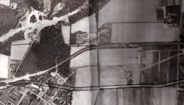
Mystery Foto #23 Solved: Planning for the Extension of Union Turnpike in Queens (Circa 1931/1932)
This weekend's Mystery Foto was a great aerial used to plan a major road.
Answers to the Mystery Foto questions:
- Identify the location
The Creedmoor section of Queens from Winchester Boulevard to Commonwealth Boulevard.
- Identify the major roads
The Long Island Motor Parkway, Winchester Boulevard, Commonwealth Boulevard, Union Turnpike and the start of construction of the Grand Central Parkway
- What is the major road being planned?
Union Turnpike
- Which Motor Parkway bridges are in the Mystery Foto?
Four: Winchester Boulevard (2), Creedmoor, and Commonwealth Boulevard.
- What is the approximate year of the aerial. Provide a rationale.
Circa 1931/1932. Rationale: The two Winchester Boulevard Motor Parkway bridges, construction of the Grand Central Parkway and the development of Union Turnpike.
Comments (14)
Congrats to Michael Labarbera, Alan W, Greg O., Al Prete, Tim Ivers, Steve Lucas, Joe Oesterle, Eric Shaffer, Sam Berliner III and Gene Perry for identifying the Creedmoor section of Queens and the planning for Union Turnpike.
Kudos to Greg O. Tim Ivers, Steve Lucas, Joe Oesterle and Art Kleiner for recognizing the two Winchester Bouleard Motor Parkway Bridges.
Enjoy,
Howard Kroplick
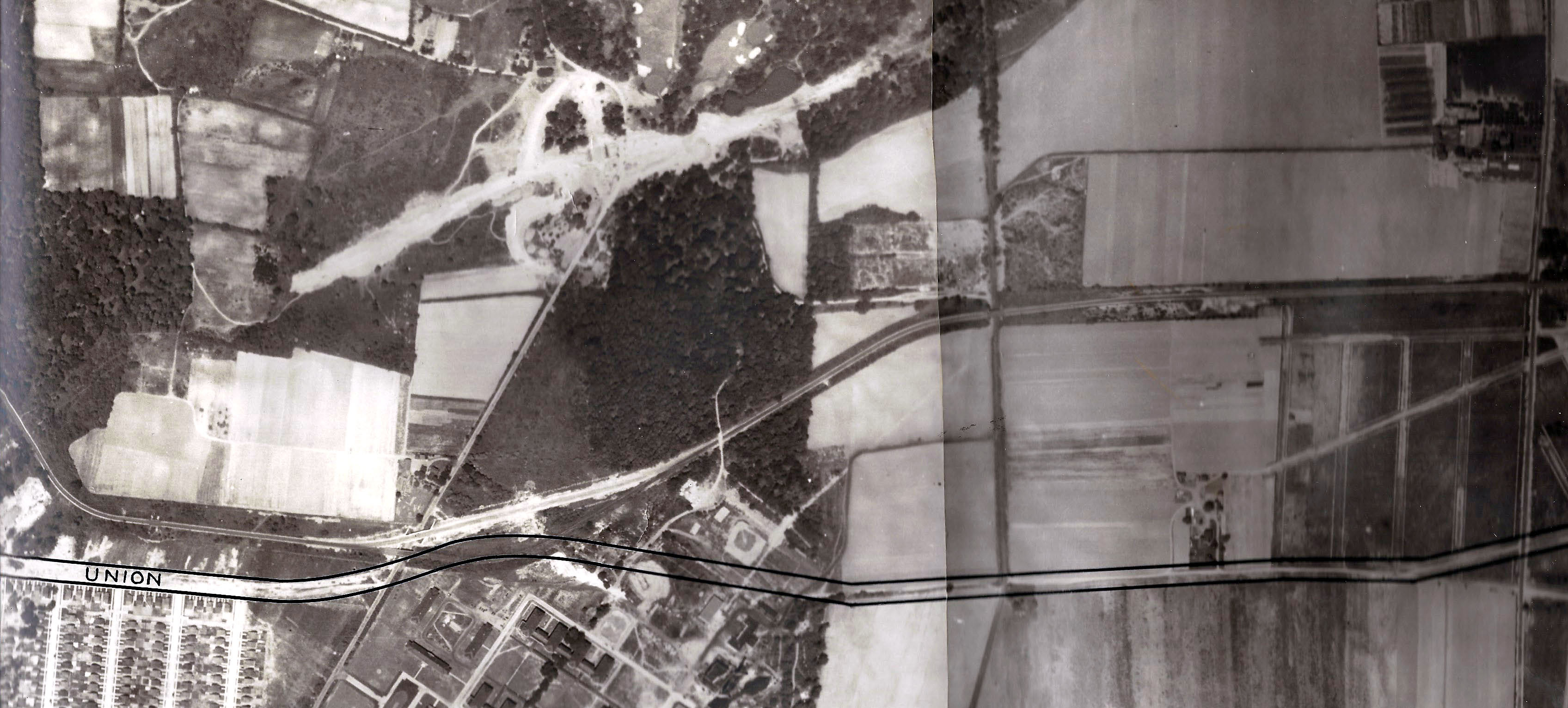
Close-Ups
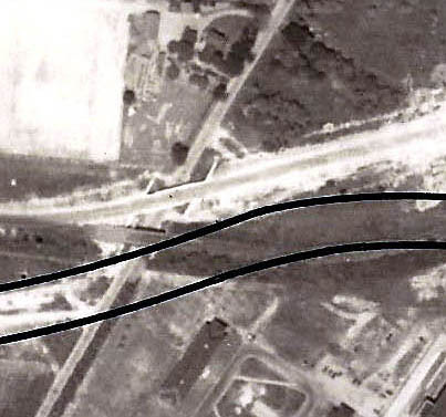
Note: The "Union" Turnpike caption
The two Motor Parkway bridges over Winchester Boulevard
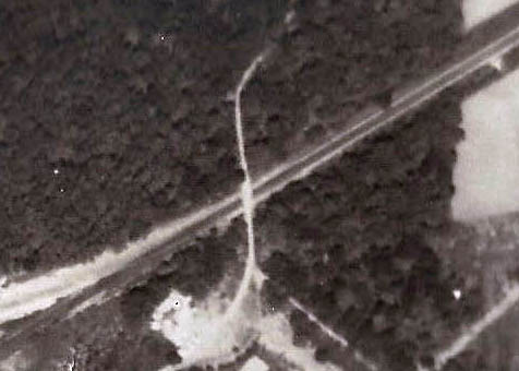
Creedmoor Motor Parkway Bridge
Commonwealth Boulevard Motor Parkway Bridge


Comments
Looks like the re routing of the Motor Parkway at Winchester Blvd just west of Creedmoor in the 1920s to make room for Union Tpk
This ts the Creedmoor/Glen Oaks area of eastern Queens circa 1930 or thereabouts. Both Union Tpke. and the Grand Central Pkwy. are in the planning or ground clearing stages. The Motor Pkwy. is shown crossing Winchester Blvd.,Commonwealth Blvd.,and Little Neck Pkwy.
-Identify the location
Directly over Creedmore
-Identify the major roads
LIMP horizontally, Winchester Blvd vertical on the left, Commonwealth Blvdvertical on the right
-What is the major road being planned?
Union Tpke
-Which Motor Parkway bridges are in the Mystery Foto?
Winchester, Creedmore, Commonwealth, and Little Neck Pkwy bridges
-What is the approximate year of the aerial. Provide a rationale.
Both Winchester bridges present so a guess would be 1931/32
What a great aerial depicting “what’s to come!” Another hard to find gem. Great stuff!!
Location is Bellerose, Queens. I assume that the planned road is indicated by the black parallel lines, and that would be Union Turnpike. Major north-south roads, which cross the Motor Parkway, are from west to east, Winchester Blvd., Commonwealth Blvd., and Little Neck Parkway. The road in the center right, which runs diagonally, is Shiloh Ave. In the upper left can be seen the Grand Central Parkway, but it looks like it’s under construction. The Cross Island Parkway is missing from the photo. Since the GCP opened in 1936 and the CIP opened in 1940, I would put the date of this photo in the early-to-mid ‘30s.
1932 Aerial over Queens
Lower left showing 2 bridges (LIMP) over Winchester Blvd.
The proposed road was Union Turnpike.
The location is over the Creedmoor-Glen Oaks section of eastern Queens County. In addition to the LIMP, other major roads include Winchester Blvd., Commonwealth Blvd., Little Neck Pkwy., and the eastern terminus (at Winchester Blvd.) of Union Turnpike, the extension of which, was the major road being planned. In the top left corner we can also see construction underway for the Grand Central Pkwy. The LIMP bridges are: Winchester Blvd. (both of them); Creedmoor pedestrian; Commonwealth Blvd.; and Little Neck Pkwy. The date of the photo is probably 1932 since there are still 2 LIMP bridges over Winchester Blvd. and construction has already started on the GCP (which began in 1931) but has not been completed to Nassau County yet which happened in 1933.
LIMP Queens. Two bridges over Winchester. Bridge over Common Wealth and Little Neck. Grand Central (Northern State) is up top. Looks like breaking ground. Union Turnpike is left to right lower in picture.
Location Queens, Union Turnpike being planned, Motor Parkway ROW above it and moving eastward paralleling the Union Turnpike marked extension. Winchester Blvd running North/South on the left Little Neck Parkway on the far right . Farm way Bridge where Creedmoor hospital now stands, time period late 1920’s.
This is a photo of the Creed farm/Alley pond park on the left and the proposed Union turnpike going east bound.The Winchester Blvd & Creedmoor bridge can be seen.Great picture Howard. Thanks for posting it. Gene
Adding to my previous comments: Why would Union Turnpike need to be improved at that time? The answer is, for the 1939 World’s Fair. I remember that similar road improvements were made in Queens for the 1964 fair: extension of the Van Wyck Expressway, and construction of the Kew Gardens interchange.
I haven’t a clue but this is very interesting. My first thought is Union Turnpike because it’s too early to be Northern State Pkwy and certainly not the LIE aborning. I just can’t find any such alignment anywhere; perhaps it’s facing south but I am so doggedly north-oriented, as are most maps and plans. There just aren’t that many places where the LIMP parallels NSP or any other major route. Hmm. Another “can’t wait”. Sam, III
Identify the location: Queens, near Creedmoor
Identify the major roads: Winchester Blvd., Commonwealth Blvd., LIMP
What is the major road being planned? Union Turnpike
Which Motor Parkway bridges are in the Mystery Foto? Old and New Winchester Blvd. Bridges, Commonwealth Bridge, Little Next Bridge, Creedmoor Pedestrian Bridge
What is the approximate year of the aerial. Provide a rationale.1932 - Union Turnpike Expansion planned but nothing done yet. LIMP has been moved.
By Creedmoor. The road being planned is union turnpike.
Can’t get enough of these oldies, thanks!
To answer a question posed above, Union Turnpike was being extended because, in the late 1920s, it was designated as a future arterial highway to Nassau County that would relieve traffic on Nassau Blvd and Hillside Ave. [A Brooklyn Eagle story at that time noted, “Motorists are forced to crawl at a snail’s place between the two counties,” a statement often still true today.] However, by 1932, thinking about the role of Union Tpke had changed thanks to NSP and GCP construction.
“Snail’s pace traffic” wasn’t the only commonality with today—there was wrangling between the state and city, too. NYC, eager for development, ended up paying for the relocation of the LIMP, and the Creedmoor underpass, when the state, city, and Lakeville Holding and Development reached a three-way agreement about the area pictured. (A later city-state dispute slightly altered the course of Union Tpke through Creedmoor to avoid bisecting the athletic areas, but destroying the baseball diamond that can be seen in the photo.)
Finally, no one commented that construction related to the Creedmoor underpass discussed in Nov 2016 posts can be seen in this picture. That Union Tpke was seen a major future arterial route explains the reason for building that underpass even though Winchester Blvd was nearby.
Mystery Foto 23A? Look carefully at the pic again, about a hundred feet west of Wheeler Farmway Bridge #2, perhaps where today’s Parks underpass is. Wuzzat? Sam, III
David, you are correct. At first Union seemed slightly different in the aerial compared to today’s map, pushing me to overlay the image. The first turn east of Winchester would ultimately be delayed a bit further east-paving over the baseball diamond as mentioned. I also had difficulty locating the underpass staircases. It appears the north stairs (just north of the lined parkway posts) was built first, as there’s no evidence of any ground breaking for the south yet.
Sam, the white ‘artifact’ on the north side of the parkway near Wheeler #2 remains a mystery. Today there’s a single tennis court at this location. But the dark blur on the roadway, directly under the artifact could well be a passing vehicle, or part of the tree on the south roadside.
continued..