The Planning and Construction of the Long Island Expressway Through the Roslyn Area: 1953 – 1959
Roslyn Landmark Society trustee Mitchell Schwartz, of Flower Hill, has published an extensive history report for the Roslyn Landmark Society on the construction of the Long Island Expressway through the Roslyn area (between exits 36 and 39) in the 1950s. The report highlights the planning and construction of the highway through the area, some of the challenges and controversies which arose, and how the opening of the LIE through North Hills, Roslyn Heights, and East Hills both alleviated traffic on the area’s surface streets and aided in the growth of Long Island’s world-class suburbs.
A significant amount of information used in writing the report was uncovered through the Bryant Library Local History Center’s archives and through the New York State Open Data website’s databases.
Schwartz has long been fascinated by the construction of I-495 through the Roslyn area, having been inspired by his Roslyn Middle School social studies teacher, Dr. Todd Postol, in 8th grade, during a pre-class conversation in which curiosity was expressed as to why Roslyn Middle School is the only school in the district south of the highway.
Schwartz, who wrote the report for the Roslyn Landmark Society, dedicates this publication to the Society – in addition to The Bryant Library, the Roslyn School District, and to Dr. Todd A. Postol – the former Roslyn teacher who first inspired him to research the highway’s history when he was a child.
Enjoy,
Howard Kroplick
The Planning and Construction of the Long Island Expressway Through the Roslyn Area: 1953 – 1959
By Mitchell M. Schwartz
Trustee, Roslyn Landmark Society Roslyn, Long Island, New York • June 2024
© Copyright 2024, Mitchell M. Schwartz and the Roslyn Landmark Society. All rights reserved.
Dedication and Acknowledgements
The author hereby dedicates this publication to the Roslyn Landmark Society, the Roslyn Union Free School District, and The Bryant Library of Roslyn. These three institutions provide the Roslyn area and its people with invaluable knowledge through their efforts to preserve its heritage, educate the public as to local history, and to instill a love & passion for learning among the members of the public of all ages. The author also dedicates this publication to Dr. Todd Alexander Postol – his former Roslyn Middle School social studies teacher who inspired him to research the history of the Long Island Expressway through the Roslyn area, when he expressed curiosity as to why Roslyn Middle School is the Roslyn School District’s only school located south of the Long Island Expressway during a pre-class conversation.
Special thanks also go to The Bryant Library of Roslyn – including Carol Clarke and Ariel Morabito, its archivists – for allowing the author to examine historic documents within the Local History Collection’s possession pertaining to the construction of the Long Island Expressway through the area.
Lastly, the author also thanks the State of New York for its Herculean efforts in digitizing and preserving its highway engineering records dating back to 1900.
Introduction
The construction of the Long Island Expressway was one of the most significant transportation infrastructure projects which has ever been undertaken on Long Island. Running 66 miles from Midtown Manhattan to Riverhead, it provides a vital link between the bustling city, the sprawling suburbs which it helped develop, and the rural East End. The highway, which urban planner Robert Moses proposed to relieve congestion on Long Island’s many surface streets and enable its rapidly expanding suburbs to more efficiently grow, was built in multiple phases between 1940 and 1972. (1)
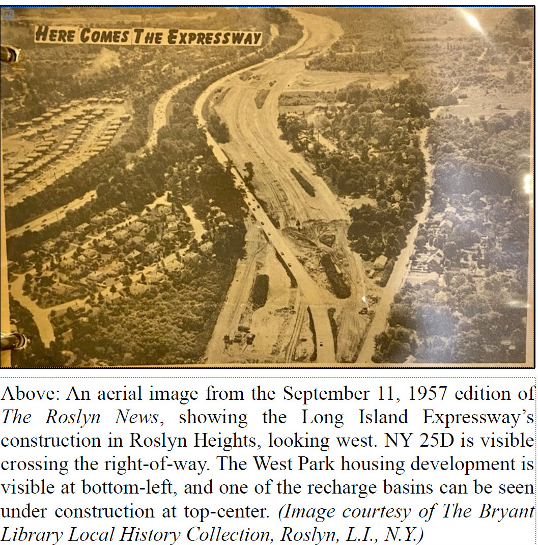
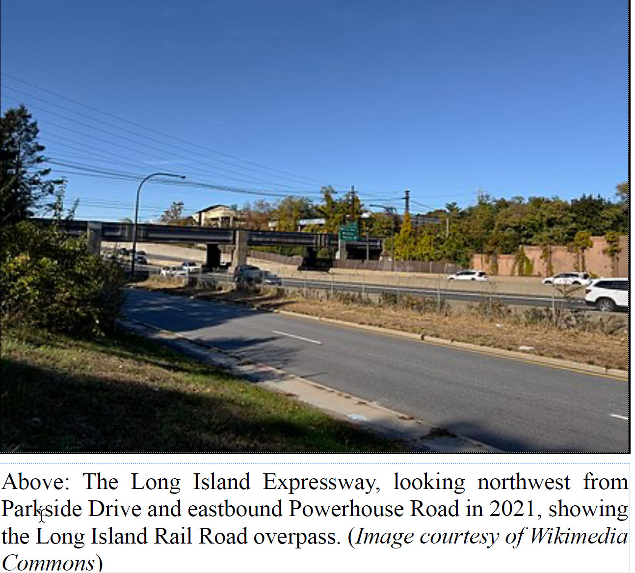
The first section of the expressway outside of New York City to open to traffic was between the New York City line (Exit 32) in the Village of Lake Success to Willis & Mineola Avenues (Exit 37) in Roslyn Heights, along the former alignment of New York State Route 25D (Nassau Boulevard and Powerhouse Road); this segment of the expressway opened to great fanfare on September 30, 1958, making the segment a major milestone in the highway’s construction.(1,2, 3) Prior to that, the North Service Road between Roslyn Road and Mineola Avenue was constructed in preparation for the next segment to Glen Cove Road – along with the Long Island Rail Road’s overpass over it and the future expressway & South Service Road.(3, 4)
The Long Island Expressway initially carried the New York State Route 24 designation, prior to that route being realigned and replaced by the NY 495 designation east of the Clearview Expressway – west of which, by then, the Interstate 495 designation was utilized. The I-495 designation was extended east along the remainder of the expressway in 1984.(5, 6)
This report provides a comprehensive analysis of the Long Island Expressway’s construction through the Greater Roslyn area, from Exit 36 (Searingtown Road) in Searingtown to Exit 39 (Glen Cove Road) in the Village of Old Westbury.
In 1953, it was reported that a new controlled-access superhighway was proposed between Midtown Manhattan and Riverhead, passing through the Roslyn area in Nassau County.5 The proposal to construct the highway, which received widespread support from many of Long Island’s officials, was approved by Governor Thomas E. Dewey in 1954, paving the way for its construction.1 7 West of the Clearview Expressway, the highway would be built as part of the recently created Interstate Highway System. As such, the construction of those segments would receive 90 percent of funds coming from the federal government, while the remaining ten percent would come from the state government. East of the Clearview Expressway – including the sections within the Roslyn area, the highway would be built as a state road, with the state and federal governments each contributing 50 percent of the funds.(1, 8, 9)
Highway Name
According to the original New York State engineering contracts for the expressway in the Roslyn area, the Long Island Expressway is also known as the “Horace Harding Expressway Extension” as far east as Glen Cove Road (Exit 39) – east of which the name changes to the Long Island Expressway; most of the original engineering contracts for the Roslyn area segments of the highway were also assigned the “HHE” (“Horace Harding Expressway” prefix in their contract numbers up to Glen Cove Road, when the prefix switches to “LIE” (“Long Island Expressway”).(4, 10, 11, 12, 13) West of the Roslyn area, the Horace Harding Expressway name would be used as far west as Queens Boulevard and the highway would mostly be built along Horace Harding Boulevard within eastern Queens; west of Queens Boulevard, it would be known as the Queens–Midtown Expressway. (4) This report references the highway within the Roslyn area as the Long Island Expressway.
Alignment
For the segments of the Long Island Expressway built between the New York City–Nassau County border (Exit 32) and Glen Cove Road in the Roslyn area (Exit 39), the highway was to be constructed along Nassau Boulevard, Powerhouse Road, and Old Westbury Road – all of which formed New York State Route 25D’s alignment through the area.4 6 Upon the construction of the expressway, the NY 25D designation would cease to exist, being replaced by NY 24, which was re-aligned onto the new highway; Nassau Boulevard, Powerhouse Road, and Old Westbury Road would all be reconfigured to become the new expressway’s service roads – along with a portion of Parkside Drive in Roslyn Heights. (4,10, 11, 12)
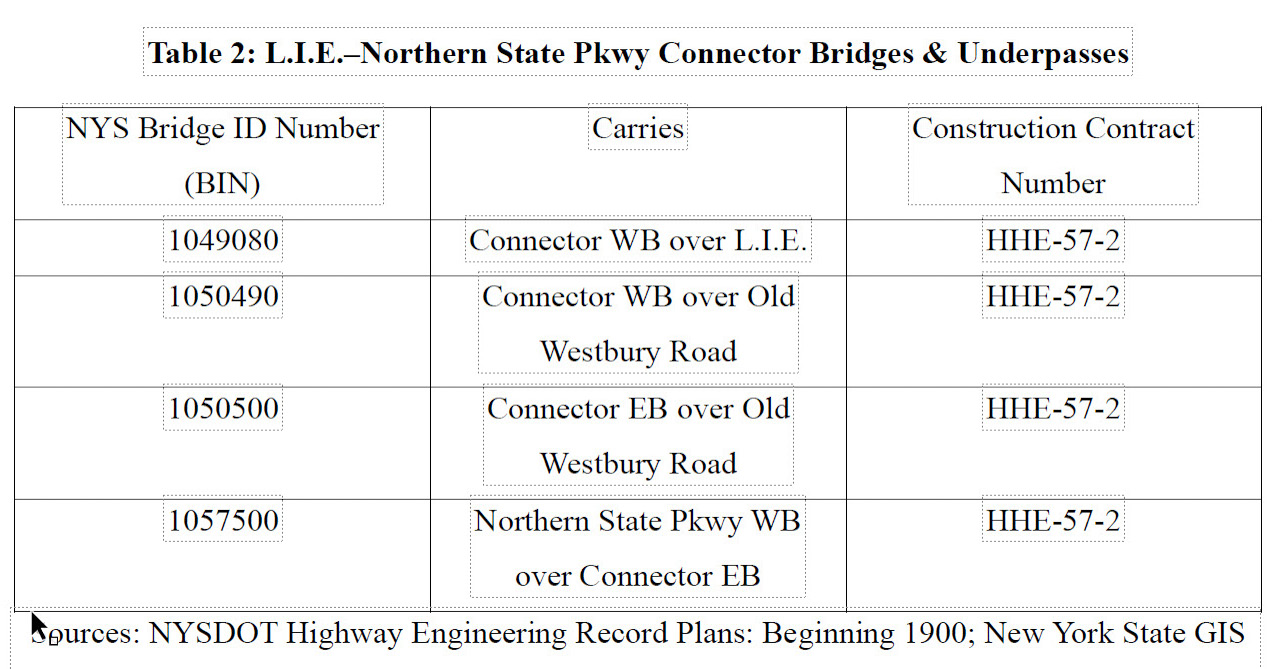
The highway’s alignment would also roughly parallel the Northern State Parkway, which had been constructed through the area a couple decades prior as part of Robert Moses’s Long Island Parkway System. A connector linking the two highways was planned to be constructed within the Village of East Hills (Exit 38 on the Long Island Expressway and Exit 29A on the Northern State Parkway), where the Northern State Parkway bends to the south and the Long Island Expressway would continue east through the Village of Old Westbury. (4, 12)
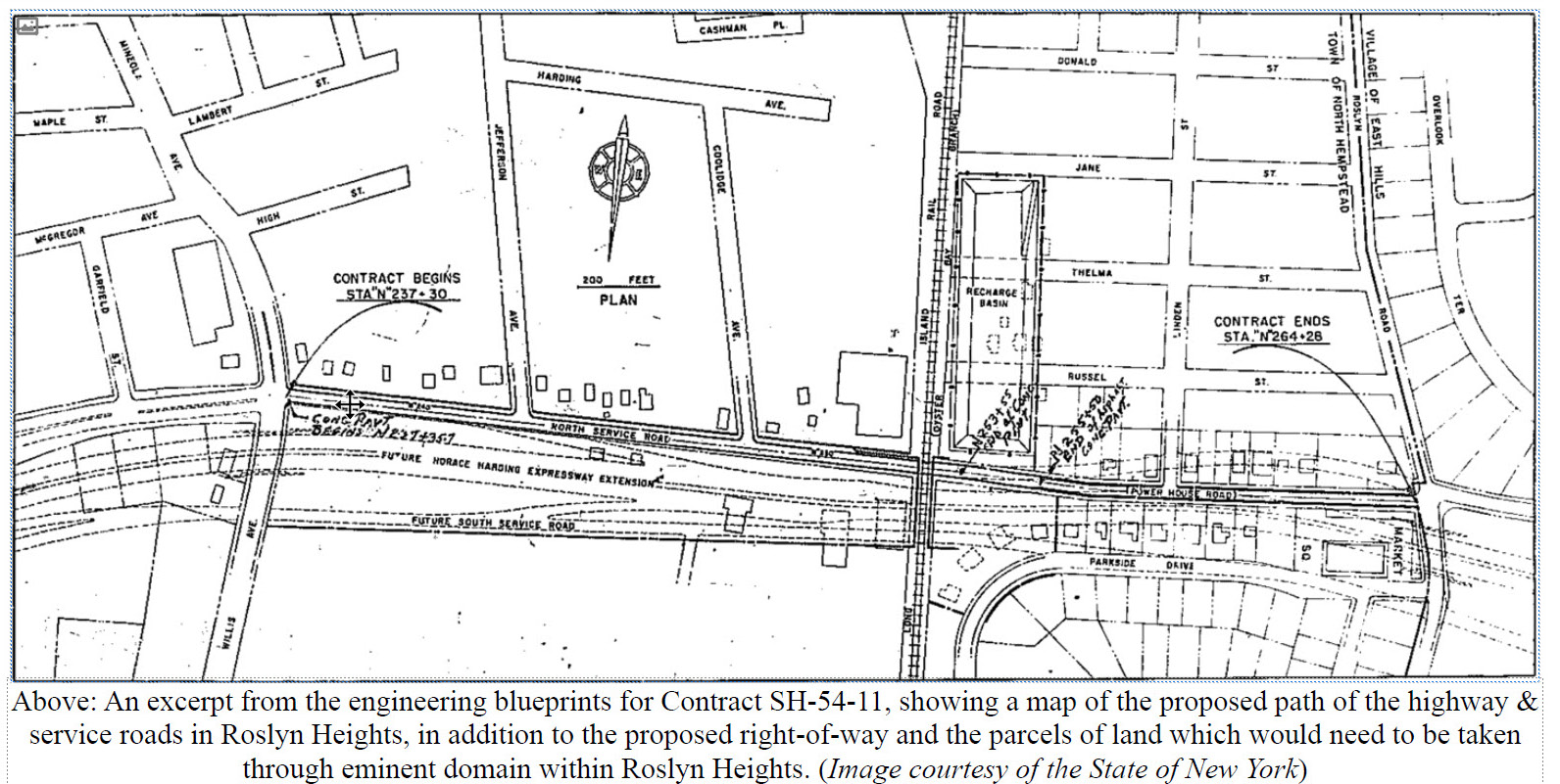
Starting at Exit 36 in Searingtown, the Long Island Expressway would run east and cross over Searingtown Road. It would then curve slightly towards the east-northeast, hugging the north side of the Levitt & Sons-developed West Park housing development and enter Roslyn Heights, before curving back towards the east.1(4) It would then rise along an earthen embankment, interchange with Willis/Mineola Avenue at Exit 37, and cross over it, before descending to grade level; a temporary roadway would direct all traffic onto the North Service Road, built under Contract SH-54-11, between Jefferson Avenue and Coolidge Avenue.(4,10,11,14) This would serve as the temporary eastern terminus of the expressway and of the first section to be built outside of New York City – and it was to be the eastern end of construction under Contract HHE-56-3.(4, 11)
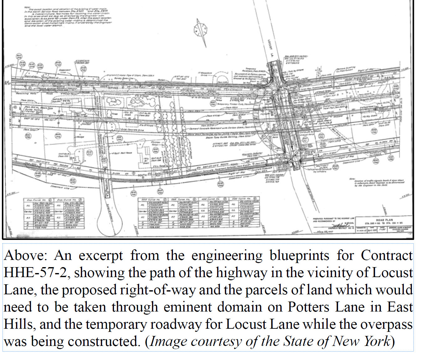
From Exit 37, the Long Island Expressway, now at the west end of Contract HHE-57-2, would continue east, descending to pass beneath the Oyster Bay Branch of the Long Island Rail Road (this bridge and portions of the North Service Road between Roslyn Road and Mineola Avenue were constructed as part of Contract SH-54-11).4 10 11 12 It would then continue through the East Park housing development, rising back up above Powerhouse Road to cross over Roslyn Road, where the expressway would enter the Village of East Hills. From there, it would continue east, passing just south of the village’s Fairfield Park and Norgate housing developments, just north of the then-new Roslyn Junior High School (present-day Roslyn Middle School), and through the northern edge of the Walter Uhl-developed Old Westbury Farms housing development; some property needed to be taken through eminent domain on the south side – including multiple houses on Potters Lane & Old Westbury Road.4 12 The highway, still on a raised, earthen embankment, would then cross over Locust Lane, and continue east along the north edge of the East Farms housing development (also developed by Walter Uhl), and then return to ground level before becoming depressed slightly below the natural grade. It would then reach an interchange with the Long Island Expressway–Northern State Parkway Connector at Exit 38, connected via an eastbound and a westbound ramp.
From Exit 38, the expressway would continue east through East Hills to its cloverleaf interchange (Exit 39) with Glen Cove Road at the border between the Villages of East Hills–Old Westbury, crossing below that street.2 Meanwhile, the connector would immediately veer south from the Long Island Expressway and cross over eastbound Old Westbury Road (the South Service Road), before merging into the Northern State Parkway at Exit 29A.(2,4, 12)
Grade Separations & Exits, Bridges & Underpasses, and Recharge Basins
Being a completely grade-separated, controlled-access superhighway, Moses planned the Long Island Expressway to cross over and beneath several roads – in addition to passing underneath the Long Island Rail Road’s Oyster Bay Branch.4 10 11 12 Four interchanges would be built within the Roslyn area: Exit 36 (Searingtown Road), Exit 37 (Willis & Mineola Avenues), Exit 38 (the Long Island Expressway–Northern State Parkway Connector), and Exit 39 (Glen Cove Road). (4,14)
The massive project, which saw significant changes in the landscape and would undoubtedly impact the existing stormwater drainage & runoff patterns, also included the construction of three recharge basins within the Roslyn area. (4, 10, 11, 12) One would be constructed in Roslyn Heights, on the north side of the highway adjacent to the Oyster Bay Branch – a project which required demolishing the western ends of Thelma Street and Russell Street and approximately seven structures, in addition to truncating the two streets at dead-ends just east of the basin; this basin was constructed as part of Contract SH-54-11.10 Another basin would be constructed in East Hills, adjacent to the westbound Long Island Expressway–Northern State Parkway Connector and Glen Cove Road; this basin was constructed as part of Contract HHE-57-2. (4, 12) A third one was constructed in the Village of North Hills, adjacent to the North Service Road and just south of present-day Christopher Morley Park, as part of Contract HHE-56-3.4 11 A fourth recharge basin was also constructed in Old Westbury, just east of the temporary terminus at Exit 39 and the Roslyn area.
The construction of these New York State-maintained recharge basins would ensure the construction of the highway would not have adverse impacts on recharging the local aquifers & the water supply or on stormwater drainage.(4, 10, 11, 12)
he alignment of the Long Island Expressway through the Roslyn area required the taking of property by the State of New York using eminent domain. This was especially true along the highway’s path in Roslyn Heights and East Hills, where several houses, commercial buildings, and other properties of varying sizes in the middle of the proposed highway’s right-of-way needed to be taken. (4,10,11,12) At the proposed interchange with Mineola & Willis Avenues at Powerhouse Road, several commercial buildings – including a restaurant and an adjacent brick gas station – needed to be taken through eminent domain and either be demolished or moved; these two structures were located approximately where the expressway bridge’s left retaining wall currently stands. (4,11,16) Just to its east, a number of additional buildings on the north side of the Roslyn Power Station (located across the street, on the east side of Willis Avenue) were in the way and needed to be demolished or moved, as well – in addition to multiple, adjacent structures; the south side of the power facility, on the south side of the South Service Road, would remain intact.(4,10, 11, 12, 14)
On the opposite side of the Long Island Rail Road’s tracks, the use of eminent domain on developed properties was significantly heavier, as the Long Island Expressway was to travel through a more developed area.(4, 10, 12) All structures on the north side of Parkside Drive in the Levitt & Sons-developed East Park neighborhood – including eleven houses and the Market Square shopping center (located at the northwestern corner of Parkside Drive and Roslyn Road, adjacent to Powerhouse Road) – were in the direct path of the highway and needed to be acquired and demolished or relocated; the westernmost three properties taken through eminent domain were also taken in order to construct the temporary railroad detour route while the adjacent, permanent Long Island Rail Road bridge was being constructed. (4, 10, 11, 12) Several properties & structures on the north side of Powerhouse Road also needed to be acquired through eminent domain and be demolished or moved to new sites.(4, 11, 12)
Further east, in the Village of East Hills, several additional structures needed to be taken through eminent domain and be demolished or moved – including four of the eight houses on Potters Lane in the Walter Uhl-developed Old Westbury Farms development and several properties on the south side of Old Westbury Road. (4, 12)
Construction
Construction soon began on building the Long Island Expressway and its related infrastructure in the Roslyn area, and the New York City-based engineering firm of Andrews, Clark, and Buckley was retained as the project’s consulting engineers for all three contracts within the Roslyn area.(4, 10, 11, 12) The land needed but not yet owned by New York State was acquired through eminent domain, structures & brush in the highway’s path were demolished or relocated, the right-of-way was graded, bridges were built, and concrete & asphalt were laid. Traffic on NY 25D in the path of construction was either rerouted or meandered across the right-of-way via temporary lanes while the new roadways were built or the existing ones were reconfigured.14 Similarly, per the engineering files for Contract HHE-56-3, traffic along the stretch of NY 25D along Nassau Boulevard Extension and Powerhouse Road, between Shelter Rock Road and Mineola & Willis Avenues, would use the existing alignment of NY 25D – including where the highway would curve from paralleling the north side of the original Nassau Boulevard to parallelling its south side and Powerhouse Road’s south side – until the new service roads were completed; upon the completion of the service roads, westbound traffic would use the new North Service Road while eastbound traffic would travel along the existing Nassau Boulevard Extension before continuing straight along a new southern service road to Willis Avenue. (4, 11, 14)
Early work included constructing portions of the North Service Road between Roslyn Road and Mineola Avenue in Roslyn Heights and the construction of the 223-foot bridge carrying the Long Island Rail Road over it and the future highway & South Service Road, per The Roslyn News and data on the New York State GIS Clearinghouse website. Properties taken through eminent domain were soon thereafter demolished or moved, and the other bridges – and the highway, itself – were soon built. (4, 10, 11, 12)
Constructing the Long Island Rail Road overpass between Exits 37 and 38 required erecting a temporary overpass just east of the permanent bridge. (4, 10) This enabled the construction crews to excavate and grade the highway’s right-of-way to the planned specifications – and to construct the permanent railroad bridge. Similarly, building the Glen Cove Road overpass at Exit 39 and many of the bridges carrying the expressway over roads, such as those at Searingtown Road, Roslyn Road, and Locust Lane, required constructing a temporary roadway to enable the highway and the permanent bridge to be constructed.(4, 10, 11, 12) This is a common highway construction technique which is still employed today.
The construction of the highway’s bridge over Locust Lane in East Hills proved controversial.(17, 18, 19) Many parents who were living in the vicinity and had children enrolled in the then-new Roslyn Junior High School (present-day Roslyn Middle School) – along with East Hills Mayor Raymond Dolar and the Roslyn School District Board of Education – grew concerned as they felt having their children cross beneath the highway would be dangerous. Several of the parents – as well as Dolar and the Board of Education – soon asked Robert Moses and Governor W. Averell Harriman to alter the proposed plans by placing the Long Island Expressway in a depressed cut below Locust Lane, thus making that street travel above the expressway via an overpass; the parents also attempted to meet with Moses, Harriman, and state engineers as part of their efforts. (20, 21) Moses and Harriman ultimately rejected the alternative proposal made by the parents, and the expressway overpass was built over Locust Lane as planned. (22, 23)
Opening
The first part of the project to be undertaken in the Roslyn area was the creation of parts of the North Service Road (a reconstructed section of Powerhouse Road), erecting the Long Island Rail Road overpass in Roslyn Heights, and building the retention basin adjacent to the tracks; this was completed by the time the first section of the Long Island Expressway opened.4 10 Meanwhile, the first section of the Long Island Expressway to be constructed in the Roslyn area was the portion constructed under Contract HHE-56-3, which brought the highway to a temporary terminus at Mineola & Willis Avenues (Exit 37) in Roslyn Heights, east from the New York City line. (4, 11) This five-mile, $7,500,000 (1958 USD) section officially opened on September 30, 1958, with a ceremony including Robert Moses, Thomas Dewey, and several other dignitaries marking the occasion.3 24 Just a day shy of a year later, at 11:00 AM on September 29, 1959, the 1.4-mile,
$4,800,000 (1959 USD) extension east to Glen Cove Road (Exit 39), at the boundary between the Villages of East Hills & Old Westbury and constructed under Contract HHE-57-2, opened – along with the Long Island Expressway–Northern State Parkway Connector (Exit 38) in the Village of East Hills.2 While this segment opened without a ceremony, unlike the one which opened the previous year, it enabled a direct link to and from the Northern State Parkway via the Long Island Expressway–Norther State Parkway Connector – and it eliminated temporary traffic bottlenecks caused by that section’s construction: traffic continuing east or west along the highway’s path between Willis & Mineola Avenues and Glen Cove Road was forced to temporarily use the service roads or other local streets during that segment’s construction. (2, 3)
The opening of the Long Island Expressway through the Roslyn area aided in relieving surface road congestion and further helped in fueling Long Island’s growth.(1, 2, 3, 6) While only representing a small portion of the highway’s overall routing, the segments built through the area proved to significant, as they enabled motorists with greatly enhanced travel options and brought the highway into Nassau County for the first time, thus paving the way for the construction of the next segment to Jericho Turnpike in Jericho and points east. (2, 4, 25)
Notes
1. Caro, Robert A. 1974. Power Broker: Robert Moses and the Fall of New York. Knopf.
2. "L.I. Expressway to Open 2 Links." The New York Times, 26 September 1959, p. 25.
3. Grene, Bob. "Moses Bids State Snap L.I. Expwy. Land: Governor, Local Officials Open 1st Nassau Link of Expressway." Newsday, 1 October 1958, pp. 3, 50.
4. “NYSDOT Highway Engineering Records: Beginning 1900.” State of New York.
5. Route Numbering Committee Agenda.” American Association of State Highway and Transportation Officials, 23 May 1984, p. 4.
6. Anderson, Steve. “Long Island Expressway (I-495)”. NYCRoads.com.
7. Bookbinder, Bernie. "Super Expressway to Link All LI." Newsday, 1 September 1953, p.1
8. Dewey Speeds L.I. Expressway: Approves Bill to Add 64 Miles.” The New York Times, 28 March 1954, pp. 1, 68
9. Unger, Mike. "Construction Ahead – For 20 Years". Newsday, 27 April 1968, p. 8W.
10. Contract Engineering Profiles: SH-54-11. Andrews, Clark, and Buckley, 1954.
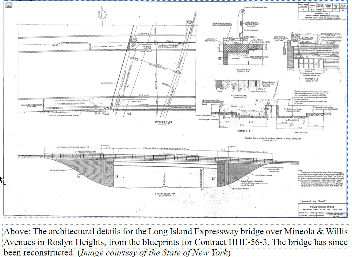
11. Contract Engineering Profiles: HHE-56-3. Andrews, Clark, and Buckley, 1956.
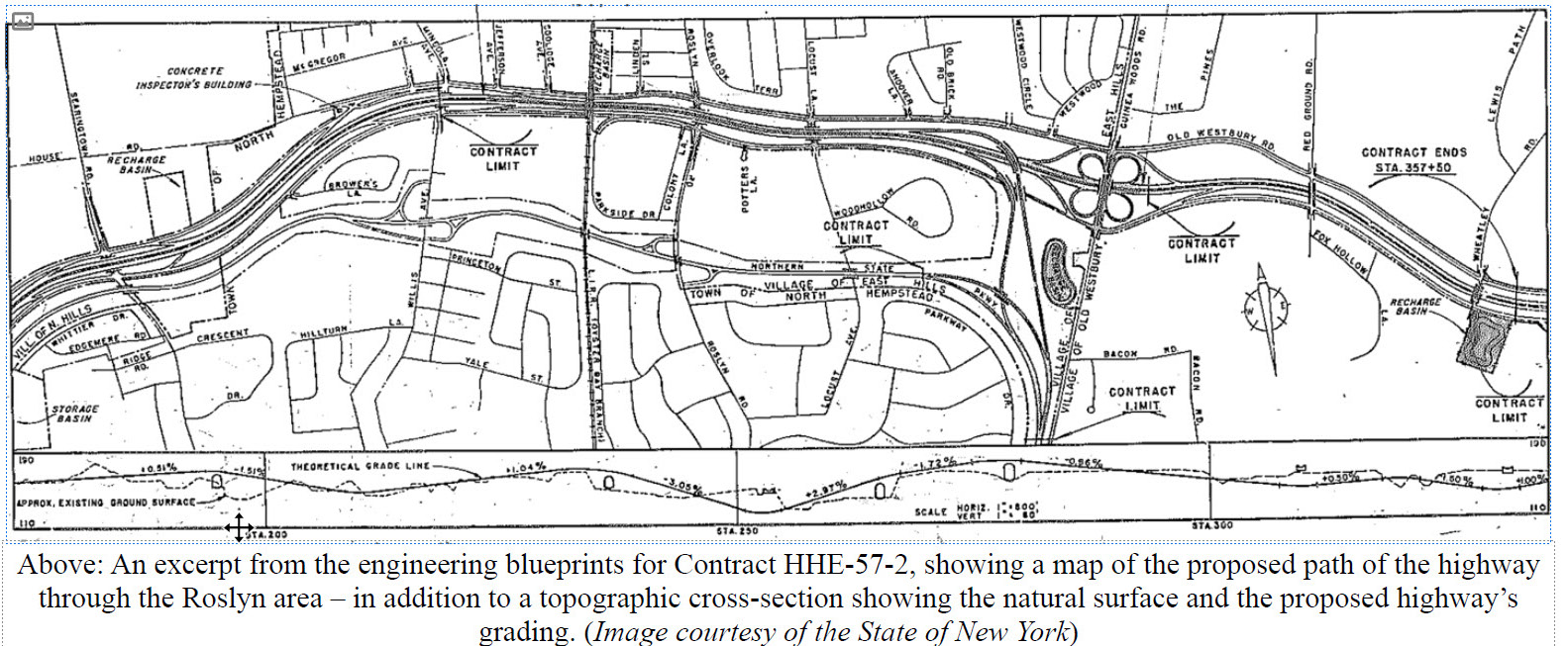
12. Contract Engineering Profiles: HHE-57-2. Andrews, Clark, and Buckley, 1957.
13. Self, Pat. “What’s Your Problem.” Newsday, 22 July 1957, p. 6C.
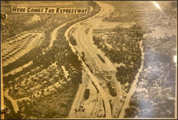
14. “Here Comes the Expressway.” The Roslyn News, 11 September 1957
15. New York State GIS Clearing House. State of New York.
16. Cummings, John. “Diner Owner Seeks Home for His Range.” Newsday, 17 April 1957, p. 5.
17. Schwartz, Lou. “Hults Vows Support to Overpass Foes.” Newsday, 1 August 1957, p. 21.
18. East Hills Overpass Foes Find Hazards at Similar NJ Project.” Newsday, 20 August 1957, p.21.
19. “Civics Beef Up War on E. Hills Overpass.” Newsday, 23 July 1957, p. 22.
20. “E. Hills Group to See Engineers (Not Harriman) About Overpass.” Newsday, 17 July 1957, p. 28.
21. “Overpass Critics Get OK to See Ave.” Newsday, 12 August 1957, p. 9.
22. “Ave Rejects East Hills Underpass Plea.” Newsday, 15 August 1957, p. 19.
23. “Ave, Moses See Overpass, Reject Pleas for Change.” Newsday, 29 August 1957, p. 21.
24. “L.I. Road Stretch to Open.” The New York Times, 12 August 1958, p. 31.
25. “Open LI Expressway to Jericho Saturday.” Newsday, 3 October 1960, p. 7.
Blueprints, Charts and Tables


Comments
Thanks for that in depth history-fascinating… and elicited a flood of memories. I grew up in the new development built just east of that LIE segment. My back yard abutted the north side of Old Westbury Rd/Powerhouse Rd (now the North Svc Road). My playmate lived on the farm across the road-they grew corn, raised chickens and ducks. We roved through farm fields and derelict estates in the area. The farm became a victim of eminent domain for the next leg of construction (their farmhouse was moved approx. 2/10th mile south/west and still stands on Glen Cove Rd a bit north of Bacon), but the farming family (the Friess’ I believe, but don’t hold me to the spelling) moved on . I do remember another much larger old colonial house- a near-mansion, located on Powerhouse Rd in East Hills about 2/10th mile east of Glen Cove Rd. This was on the segment you describe. I remember when it was moved on a tractor trailer rig in 2 sections up Glen Cove Road to a location about 1/4 mile north of Harbor Hill/Red Ground Rd-where it still stands.
In the weeks before the next segment (east of Glen Cove Rd) opened, we would sneak our bikes onto the new asphalt of the LIE and ride down past Red Ground to Wheatley Rd. I recall that the surface was great for locking the coaster brakes and fishtailing. Then, unexpectedly, came opening day ribbon cutting… we were there cruising around as usual on our bikes… little squirts getting in the way and worming through the crowd to fetch free drinks and shake hands with then Gov. Nelson Rockefeller and some other unknown notables, but mostly realizing that this was to be the loss of our private stretch of biking heaven.
Very interesting article. My one question is the mention in the article and by Fred Eisenstein of the roadway being asphalt. I thought the original road was concrete, with an odd little inclined curb that rose up to a cobblestone shoulder (I recall reading-probably in Newsday-that the curb could not be negotiated with a flat tire). I believe a good deal of the old concrete still exists under layers of asphalt-you can see it when the asphalt pot holes out. I’ll bet the original concrete lasted a lot longer than the ensuing resurfacings that were done.
To Bob: could be, but I recall it as being nice smooth black asphalt-but as they say, with age, my short term memory is declining, while my long term memory is getting so good, I’m remembering things that may not have even happened…
Now Glen Cove Rd- that was beige concrete with black tar strips bordering every approx 50 ft section- 4 lanes, 2 in each direction, and quite adequate for cars as wide as a Model A Ford
The map below is on Instagram page for Roslyn. Aerial captured during the construction of the LIE. Appeared familiar to me, then rotated it to North; and labeled some roads.