A Map of the Long Island Motor Parkway & Queens Historical Sites
Steven W. comments: "Do you have a road map of the full route of the Motor Parkway with surrounding residential streets? This would be highly appreciated, as I would love to see it and bike through the trails of the demolished part in Nassau County".
Steven, the primary route of the Long Island Motor Parkway was completed in 1926 with a three-mile extension in Queens. Accordingly to track the Motor Parkway from end to end, you would need post-1926 maps of Queens, Nassau and Suffolk counties. Many 1940s maps showed the abandoned Motor Parkway route in relation to existing major streets. Based on this type of map, I have created a 15-page pdf that shows the entire 44-mile right-of way from Horace Harding Boulevard in Fresh Meadows to Lake Ronkonkoma. The Motor Parkway is marked in blue.
Below are some of the historical sites that can be found on the Motor Parkway in Queens. Next week, Nassau and Suffolk County sites will be posted.

The site of the Motor Parkway's last Western Terminus at Peck Avenue and Horace Harding Boulevard

Follow the mile and a half bike path over the Motor Parkway created by Robert Moses in 1938. The entrance is off Peck Avenue north of 67th Avenue

The bike path goes over three identical Motor Parkway bridges that were built from 1924-1926. The first one carried the Motor Parkway over 73rd Avenue.

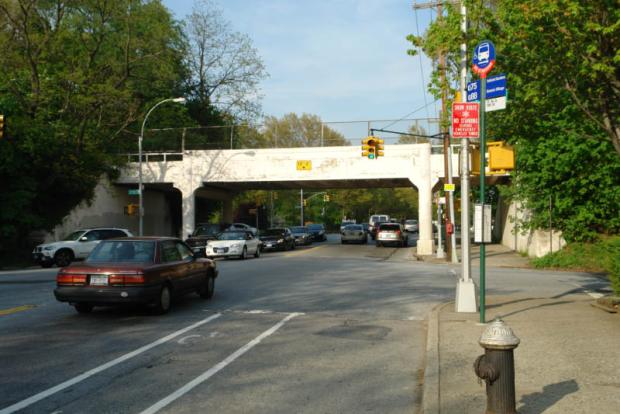
The beautiful Motor Parkway Bridge over Hollis Hills Terrace.

Along side the Motor Parkway Bridge over Springfield Boulevard (formerly Rocky Hill Road) were the entrance and exit leading to the Rocky Hill Road Lodge. Note: The ramp to the right.

The hidden Wheeler Farmway Bridge near 226st Street.
Links to related posts on VanderbiltCupRaces.com:
Index: Long Island Motor Parkway
Long Island Motor Parkway- Queens
Long Island Motor Parkway- Bridges


Comments
Steven, my website has additional info. regarding the location of the Motor Parkway with maps and pics. Feel free to take a look and contact me for more info.
Howard, hope you don’t mind me sharing here.
http://limparkway.webs.com/
Hi Art:
Thanks for the link!
Howard
Hi Howard
On the Wheeler Farmway bridge, you mentioned the concrete “tops” are still visible on both sides of the LIMP. And Robert Miller stated he had crawled “under” to investigate the bridge years earlier. I’m assuming the LIMP ran OVER the 226 street Farmway bridge but not sure. Maybe that would explain the LIMP uphill shown behind the Rocky Hill Lodge photo. Based on bits and pieces, the farmway bridge should have been approximately 200 feet east of the lodge. It looks about right. Another question about the Rocky Hill lodge. After bike riding the LIMP recently, I’m noticing the existing exit/entrance ramps are only 270 feet approx in length running easterly from Springfield Bl (Rocky Hill Rd) before intersecting the LIMP. The lodge (based on more bits and pieces) should have been located 500 feet east from Springfield Bl. Were there additional ramps located here at the Rocky Hill Lodge? There is an aerial photo (little blurry) posted here of the lodge looking easterly, perhaps showing a total of four ramps: Two wider, longer, spread further apart ramps leading directly to the lodge, and what appears to be two shorter ones (the existing ramps?) running just beside both sides of the LIMP. Though I’ve lived in Woodside and frequently biked to all parts of this area as a teen, the LIMP had managed to hide and escape from my sight all this time. Thanks to you and to all for bringing it into view for everyone to enjoy.
Hi Howard. After viewing the PDF maps of the LIMP, I guess the left turn into Horace Harding Blvd on the Fresh Meadows,Queens PDF is the ROW that was the Central RR. I went to Arrts Archives to check out that area. When the LIMP was built in that location, the tracks were gone; but the path existed (between Peck and Underhill Ave.) I’d like to get a hold of old hagstroms,etc. Guess I’ll look on ebay or something. Your doing nice work here, Howard.
Sincerely,
Brian D McCarthy
I did a cycle trip for anyone interested that I created with locations and directions: https://newsblaze.com/usnews/travel/1908-vanderbilt-motor-parkway_141959/?fbclid=IwAR2VegS7d_Ij44rwV6xkz5T75eljh—4snkiNE9H9Is5Cjq-5n_pBm3GXQc