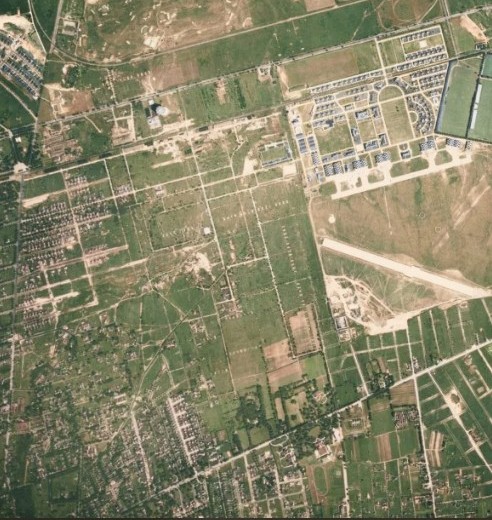
Mystery Friday Foto #12 Solved: A 1938 Aerial…In Color!
Can you identify this color aerial?
Identify;
- The location and orientation
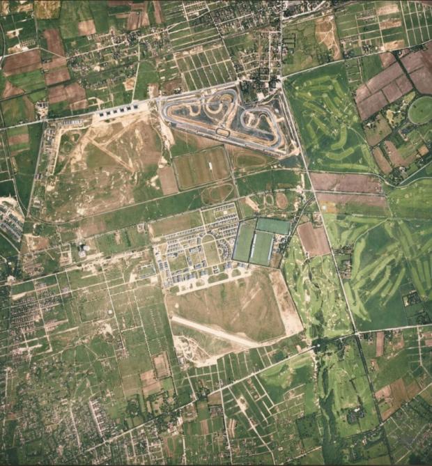
This colorized aerial is above Roosevelt and Mitchel Fields. North upwards.
- Year- provide a rationale
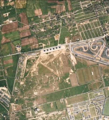
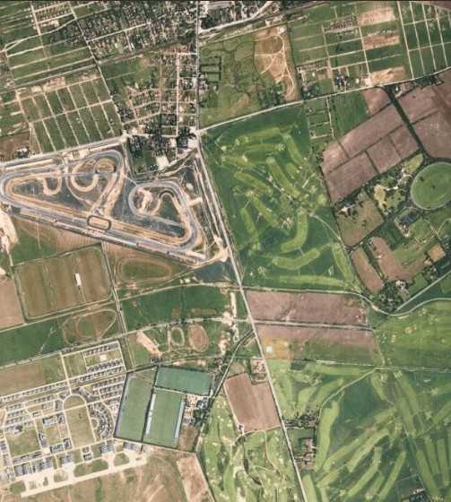
1938 The best evidence that this is 1938 is the small, one-year-only midget race track on top of the older Vanderbilt Race Courses of 1936/37.
- The Motor Parkway and all Motor Parkway structures within the frame
- Flying Field(s), golf courses and any significant non-Motor Parkway structures/items
See reader's extensive answers below
- Kudos question: How many Vanderbilt Cup Races occurred within this frame?
1904, 1908, 1909, 1910, 1936, 1937, and 1960 for a total of seven portions of race courses could be seen within this frame.
Congrats to Al Prete, Joseph Oesterle, David Miller, James King, Roy Warner, Steve Lucas, ErnieM, and Lee Chambers for identifying the location. Kudos to Steve Lucas for correctly identifying every Vanderbilt Cup Race course that was partially, or fully in the frame.
Greg O.

Close ups


Comments
Location: Westbury/Uniondale area. North is at the top. Year: 1939, as you can see both configurations of Roosevelt (auto) Raceway at the top of the Foto, and no Meadowbrook Parkway north of the Southern State.
Lots to see here. From top to bottom: Old Country Road, Motor Parkway, Stewart Avenue, Central RR, and Hempstead Turnpike. Merrick Avenue on the right. West of Merrick Avenue: Roosevelt Raceway, Mitchel Field, Meadow Brook Polo Club, and one of the Salisbury golf courses. East of Merrick Avenue: Two more Salisbury golf courses and the Ladenburg property. Barely visible is the Meadow Brook toll lodge.
Two VCRs were run at the Roosevelt Raceway, in 1936 and 1937.
Roosevelt Field Area. Mid 1930’s, with the revival of the Vanderbilt Cup Races. I see LIMP under Old Country Rd, the Mayan Ruins, over Clinton Ave, the two side by side Roosevelt Ave bridges, the Meadowbrook Lodge, bridge over Merrick Ave, and both bridges on the far side of Eisenhower Park.
We are directly over Mitchell field (Garden city). Orientation is: North=up. This is August 1938. The new NW to SE runway is completed but to the right of it the NE to SW runway isn’t built yet. Roosevelt airfield is operating in upper left in pic. Salisbury golf club is near right side. In the middle (left to right) is the LIMP. Meadowbrook lodge just west of Merrick ave. I’ll guess 4 Vanderbilt cup races within this frame. 1904, 1908, 1909, and 1910.
The location is Roosevelt Air Field and Roosevelt Raceway in Westbury, NY. The top of the picture is north. The year is most likely 1938 because of the existence of the short oval race track that hosted a Midget car race in 1938 only. The following year in 1939 a 1/2 mile oval was built to host a Midget car race, and the larger oval track does not appear in the picture. Vanderbilt Motor Parkway can be seen running east/west just south of the Roosevelt Field property, and it runs parallel to Stewart Av. which is the next major roadway south of Motor Parkway. Salisbury Country Club in East Meadow, later renamed Salisbury Park in 1949 and then renamed Eisenhower Park in 1969, can be seen east of the Roosevelt Field property.
Vanderbilt Cup races were run on Motor Parkway from 1907 through 1911, and were run at Roosevelt Raceway in 1936 and 1937.
I can make out some of it. Looking due north. Bordering the left side is the N/S Motor Pkwy with its turn to head due East, which parallels Stewart Ave. Then farther south is E/W Hempstead Tpke, with Mitchell Field abutting it on the North. Then farther east along Hempstead Tpke is the golf course that became part Eisenhower Park. However, there is no Meadowbrook Pkwy or any of the housing developments bordering Old Country Rd, which is visible at the top border of the photo. Plus all the other incidentals, the Motor Pkwy bridge over Clinton Rd, etc. The lead photo of today’s issue shows the 1936 race. Regardless, the photo is obviously pre-War II and, without my knowing when the race course was built, after 1930 anyway.
We are over Westbury with north at the top of the photo. I’m thinking the date is 1938 because both the 1936 and 1937 Vanderbilt race courses can be seen and the LIMP bridges are still intact. The limp runs from upper left, then south before curving east through the middle of the photo. Both Roosevelt and Mitchell fields can be seen. LIMP structures include bridges at Old Country Road, Clinton Road, two at Roosevelt field, Merrick Avenue, Newbridge Avenue/Bellmore Road, and Stewart Avenue. Also the “Mayan Ruins” and Meadowbrook Lodge. Golf clubs include Salisbury Links, Meadowbrook GC and the course near the Clinton Road brdge whose name escapes me. We can also see the Meadowbrook Polo Club. At least some of the courses for the following Vanderbilt Cup races can be seen: 1904, 1908, 1909, 1910, 1936, 1937, and 1960 for a total of seven.
The location and orientation:
Directly over Roosevelt and Mitchel Fields. North is the image top.
Year- provide a rationale:
Between 1936 and 1940. The evident Roosevelt Raceway Auto
racing track opened in 1936, and the Harness racing track
opened on the same site in 1940.
The Motor Parkway and all Motor Parkway structures within the frame:
Clinton Road (Glen Cove Road) Parkway Bridge 1909 - 1939
Garden City Lodge Ramp
Garden City Lodge 1909 - 1989
Long Island Motor Parkway Headquarters (Second Location) 1914 - 1938
Roosevelt Field Highway Bridge Underpass 1909 - 1940’s.
Meadow Brook Lodge 1908 - 1960s
Meadow Brook Lodge Ramp
Merrick Avenue (Whaleneck Avenue) Parkway Bridge 1908 - 1940s
Newbridge Avenue (Bellmore Road) Parkway Bridge
{Meadow Brook Bridge} 1908 - 1947
Stewart Avenue Highway Bridge Underpass 1908 - 1947
Flying Field(s):
Roosevelt Field
Hazelhurst Aviation Fields or Mitchel Field
Golf courses:
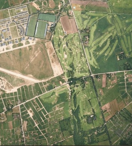
Salisbury Country Club Re Course
Other non-Motor Parkway structures/items:
Roosevelt (automobile) Raceway (1924-1938)
Meadow Brook Hunt Club Main Polo Fields and grandstand
Central Railroad Bridge at Meadow Brook Hunt Club
Kudos question: How many Vanderbilt Cup Races occurred within this frame?
Two. 1936 and ‘37 (I suspect this is a trick question)
If anyone knows the identity of the green oval top left of the image please let me know.
This photo which was colorized with AI by noted Military Historian and researcher Zachary Hudson shows the LIMP, Stewart Avenue and the Central Railroad of Long Island (later, LIRR) all following a parallel course running left to right. Then, all three in unison curve in a Southeasterly direction as they pass Merrick Ave. and cross what were the Salisbury Links Golf Club.
Also nearby was the original course of Roosevelt Raceway (for cars), long before horses made the scene. The series of twisting, looping curves (ala a Grand Prix course) were later modified into a simpler pattern of elongated straightaways (ala Indy tracks) for maximum speed craved by race fans.
Elsewhere, the Grandstands which held about 40,000 people at the Polo Grounds can be seen at the middle right of the photo. The LIRR ran special service through Mitchel for the matches, dropping off spectators just before what became Endo Blvd. From there, they would walk over to the playing field. Today, that property is the location of NCC’s East campus built over a ten year period in the 1970’s.
Immediately East of Mitchel Field was the Meadow Brook (two words) Golf Club who offered pro-bono memberships to Officers and to Enlisted Men if they agreed to caddie for the Officers.
Below Hempstead Turnpike and also hugging Merrick Ave. was the Cold Stream Golf Club, immediately to the East of the Santini area. LI was a golfer’s paradise back then (but for the planes flying at low altitude overhead!).
Hi Ernie M - The green oval at top right was once the horse track on the Emily Ladenburg estate. Today the oval serves as the backyard play field for the East Meadow School District. Note the 1914 map below shows some inaccuracies
Below:
1914
1938
2023
Thank you Frank!
Steve, The golf course near the Clinton Ave, bridge was the Old Westbury Golf Course. Closed 1943.
Lee, With regard to the problem of low flying planes over the local golf courses, between 1928 and 1930 there were at least four occasions where planes ended upon the abutting Old Westbury Golf Course.
Lee, back again, From time to time there were parachute jumping displays over the airfield. On November 13, 1929 sixteen parachutists jumped out of a plane over the airfield. The majority of the jumpers landed on the airfield, at least four of them landed on the golf course.