Tag: Survey Maps
-
Nov 01 2016
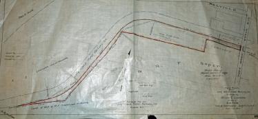
The Union Turnpike/Long Island Motor Parkway Pedestrian Underpass
My favorite co-author Al Velocci found a 1929 blueprint showing plans for a pedestrian underpass under the Motor Parkway and Union Turnpike. It turns out that I had two construction plans of the proposed underpass in my survey files.
-
Jan 20 2016
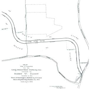
Anatomy of a 1910 Survey: Proposed Location of the Deer Park Lodge
My favorite co-author Al Velocci was fascinated by last week's post on the Deer Park Road Motor Parkway Bridge and especially the 1910 March survey.
-
Jul 29 2010
The Long Island Motor Parkway Survey Bookmap: Fresh Meadows- The Western Terminus
One of the treasures of my original Motor Parkway survey collection and a key to to the survey maps is a 22-page 1910 "Bookmap" documenting the right-of way, the original property owners, and the corresponding survey plan #s.This Atlas includes the entire 44-mile right-of-way with surveyor notes added in 1929 and 1930. Starting from west (Fresh Meadows) going east (Lake Ronkonkoma), here is the first page of the Atlas with an accompanying aerial and photos (click to enlarge).
-
Jun 22 2009
Original Survey Maps of the Long Island Motor Parkway Discovered!
Over the last 80 years, the survey firm of Barrett, Bonacci and Van Weele has acquired many Nassau and Suffolk survey firms, including several which conducted work for the Long Island Motor Parkway, Inc. Within their historical files were 572 survey maps of the Motor Parkway dating from 1907 to 1985. These maps will be posted exclusively on VanderbiltCupRaces.com over the next year.

