Tag: Motor Parkway Survey Bookmap
-
Jul 25 2020
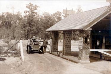
Documenting the Location of the Bethpage Lodge
Johnny Karate is looking for documentation on the location of the Bethpage Lodge.
-
Mar 28 2020
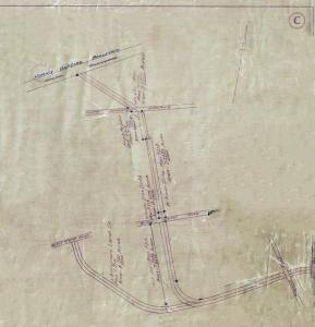
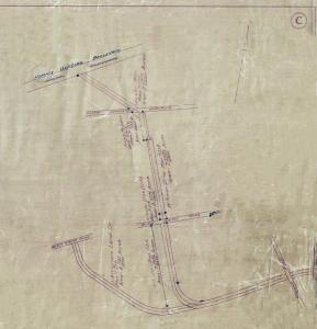
Motor Parkway Survey Bookmap C: The Western Terminus in Fresh Meadows, Queens
This is the first of a new series documenting the newly renamed 1910 Motor Parkway Survey "Bookmap". It highlights the first page of the 22-page canvas document: Map C showing the Western Terminus from Nassau Boulevard (Horace Harding Boulevard) to Queens Road (Hollis Hills Terrace).
-
Mar 23 2020
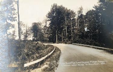
Mystery Foto #12 Solved: A View Along the 10-Mile Curve in Dix Hills & the “View” Postcard Series
To promote the restaurant/inn Petit Trianon and the Motor Parkway in 1912, Long Island Motor Parkway, Inc. hired a photographer to develop the "View Along the Long Island Motor Parkway" series. These postcards were sold at Petit Trianon. My favorite co-author Al Velocci challenged you to identify this postcard.
-
Mar 21 2020
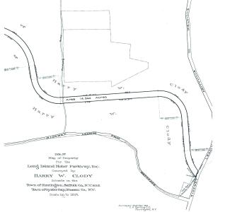
VanderbiltCupRaces.com Exclusive: The 1910 Motor Parkway Survey Bookmap
In 2009 I purchased 572 original Motor Parkway surveys and maps from the firm of Barrett, Bonacci and Van Weele. One of the treasures of this purchase was a 1910 "Bookmap" documenting the right-of way, the original property owners, and the corresponding survey plan #s.
-
Dec 28 2011
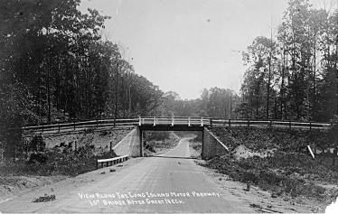
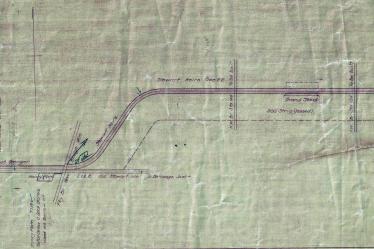
Long Island Motor Parkway Bridge Series:#15 The Smith Farmway Bridge in Lake Success(Update: 4/1/20)
Going west to east, the third Nassau County bridge built by the Long Island Motor Parkway was a farmway bridge connecting the Richard W. Smith property in Lakeville later renamed Lake Success.
-
Jul 29 2010
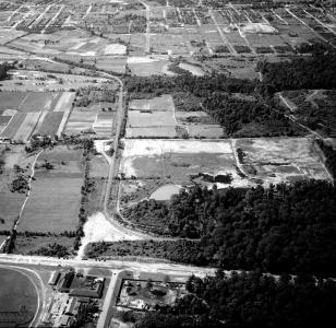
The Long Island Motor Parkway Survey Bookmap: Fresh Meadows- The Western Terminus
One of the treasures of my original Motor Parkway survey collection and a key to to the survey maps is a 22-page 1910 "Bookmap" documenting the right-of way, the original property owners, and the corresponding survey plan #s.This Atlas includes the entire 44-mile right-of-way with surveyor notes added in 1929 and 1930. Starting from west (Fresh Meadows) going east (Lake Ronkonkoma), here is the first page of the Atlas with an accompanying aerial and photos (click to enlarge).
-
Dec 04 2009
The Planned Fresh Meadows Motor Parkway Western Terminus in 1912
As noted in earlier posts, the final western terminus of the Long Island Motor Parkway was located at the Nassau Boulevard intersection in Fresh Meadows. However, a review of original Motor Parkway survey maps indicate that this was not the original plan.
-
Jun 22 2009
Original Survey Maps of the Long Island Motor Parkway Discovered!
Over the last 80 years, the survey firm of Barrett, Bonacci and Van Weele has acquired many Nassau and Suffolk survey firms, including several which conducted work for the Long Island Motor Parkway, Inc. Within their historical files were 572 survey maps of the Motor Parkway dating from 1907 to 1985. These maps will be posted exclusively on VanderbiltCupRaces.com over the next year.

