Then and Now
-
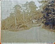
Jan 08 2011
Then & Now: The Botto Farmway Bridge in Bethpage State Park
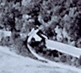
When the 48 miles of the Motor Parkway were completed in the late 1920s, a total of 65 bridges had been built over and under the parkway. Most of the bridges were used to avoid intersections of major roads. However, many of the bridges were built to connect adjoining properties and farms. These "farmway" bridges were part of the negotiations when the Long Island Motor Parkway, Inc. purchased the right-of way. One of the farmway bridges connected the east and west sections of the Botto farm…
-
Sep 14 2010
Then & Now: The Ronkonkoma Lodge
Andy Hartwell comments: "A few months back I took a ride to the eastern end of the current Motor Parkway - right up to the lake - looking for any signs of the old Ronkonkoma Lodge. Nothing jumped out at me. Any chance you can pinpoint the exact location on a google earth map for me? Maybe some then and now pics too?" Andy, you ask for it , here is your: Then and Now: The Ronkonkoma Lodge
-
Sep 06 2010
Then & Now: The Jericho Turnpike Motor Parkway Bridge and the Mineola Lodge
Sara Danz comments: "I remember seeing a photo of the excavation of the LIMP UNDER Jericho Turnpike just south of this. Has anyone ever seen this photo? I haven't been able to find it again."
-
Aug 30 2010
Then & Now: The Motor Parkway in Wheatley Hills Golf Club, East Williston
Last Sunday, we explored the history of the Motor Parkway right-of-way that virtually split the Wheatley Hills Golf Course in East Williston. In order to obtain this East Williston right-of-way, the Motor Parkway purchased the entire 68-acre farm of William Titus in 1909. Four years later, the property was sold or leased to develop a golf club which became Wheatley Hills. For many years, LIMPers asked the question, do any remnants of the Motor Parkway still remain on this private property?
-
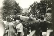
Jun 23 2010
Then & Now: The Railroad Bridge on Ellison Road in Westbury
One of the most spectacular vantage points of the 1908 Vanderbilt Cup Race course was the Long Island Rail Road Bridge on Ellison Road in Westbury. Drivers mounting the sharp grade of the bridge would often find the wheels of their cars lifting off the road as if they were about to launch into flight. Here' s proof (remember to click on the images to enlarge them):
-
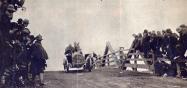
Jun 01 2010
Then & Now: “The Most Difficult Turn” on the 1906 Vanderbilt Cup Course
John M: "My family has a legend connected to the Cup races. My Grandmother's family at one time lived in the house on the triangle at Mineola Avenue and Old Northern Boulevard. One year the race went by the house and they supposedly did a good business selling sandwiches and allowing parking for a very high price to race goers out from the city."
-
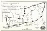
Mar 06 2010
Then & Now:The Woodbury Turn of the 1908 Vanderbilt Cup Race
Nassau County made up the vast majority of the Vanderbilt Cup Race courses. For the 1904 race, approximately one mile of the 30-mile course was in Queens- linking Hempstead Turnpike with Jericho Turnpike. All the other courses (1905-1910) were located totally in Nassau County. The closest the race came to Suffolk County was the north-east section of the 1908 Vanderbilt Cup Race which is the subject of today's then and now post- the Woodbury Turn.
-
Feb 18 2010
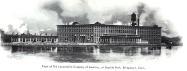
Then & Now: The Locomobile Factory in Bridgeport
Old 16, the first American car to win a Vanderbilt Cup Race, was manufactured directly across the Long Island Sound in Bridgeport. Here are some photos of the Locomobile factory, one of the largest automobile manufacturing plants of its era. Remember to click on the photo to enlarge it.
-
Dec 28 2009
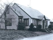
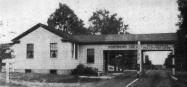
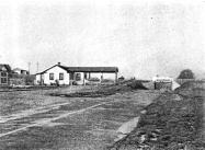
Then & Now: The Motor Parkway Office in Garden City
From 1915 to mid-1929, the first Long Island Motor Parkway Office was built in Garden City. In 1929, the small office was replaced by this attractive building which served as the office for General Manager Alfred Kienzle.
-
Dec 25 2009
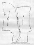
Then & Now: Lake Success during the 1905 Vanderbilt Cup Race
As shown in this map of the 1905 Vanderbilt Cup Race, Lakeville Road in Lake Success and New Hyde Park made up the western section of the course.

