Mystery Friday Foto #53 Solved: A Stretch of the Motor Parkway in Bethpage
Can you identify this stretch of the Motor Parkway?
Identify;
- Where was this stretch of the Parkway?
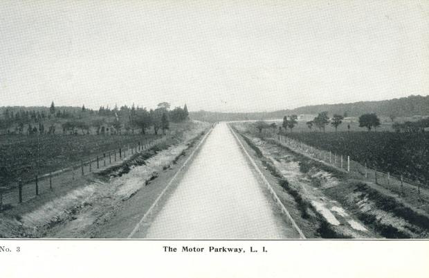
This stretch on this postcard was just after Dead Man's curve in Central Park, now known as Bethpage.
- Exact location and orientation of the photographer
Standing on top of the Powell Ave. Bridge looking North.
- Any Motor Parkway structures in the photo
The Plainview Road highway bridge can be seen towards the right side of the photo where the Parkway turns eastward.
- What 2 races used this portion of the Parkway?
The 1908 Motor Parkway Sweepstakes and the 1908 Vanderbilt Cup Race were the only 2 races held on this stretch of the Motor Parkway after opening in 1908. The identical 1909 and 1910 course was considerably smaller and did not go as far as Dead Man's Curve in Central Park.
Comments (6)
Congrats to Joseph Oesterle, Steve Lucas, ErnieM, and Frank Femenias for identifying this stretch in Central Park (Bethpage).
Greg O.
Then
1908.
Now
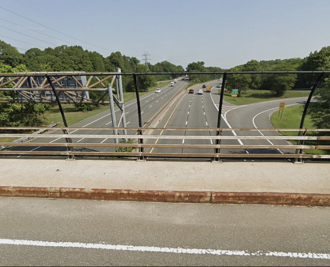
This is the view from atop the current Powell Ave. bridge.


Comments
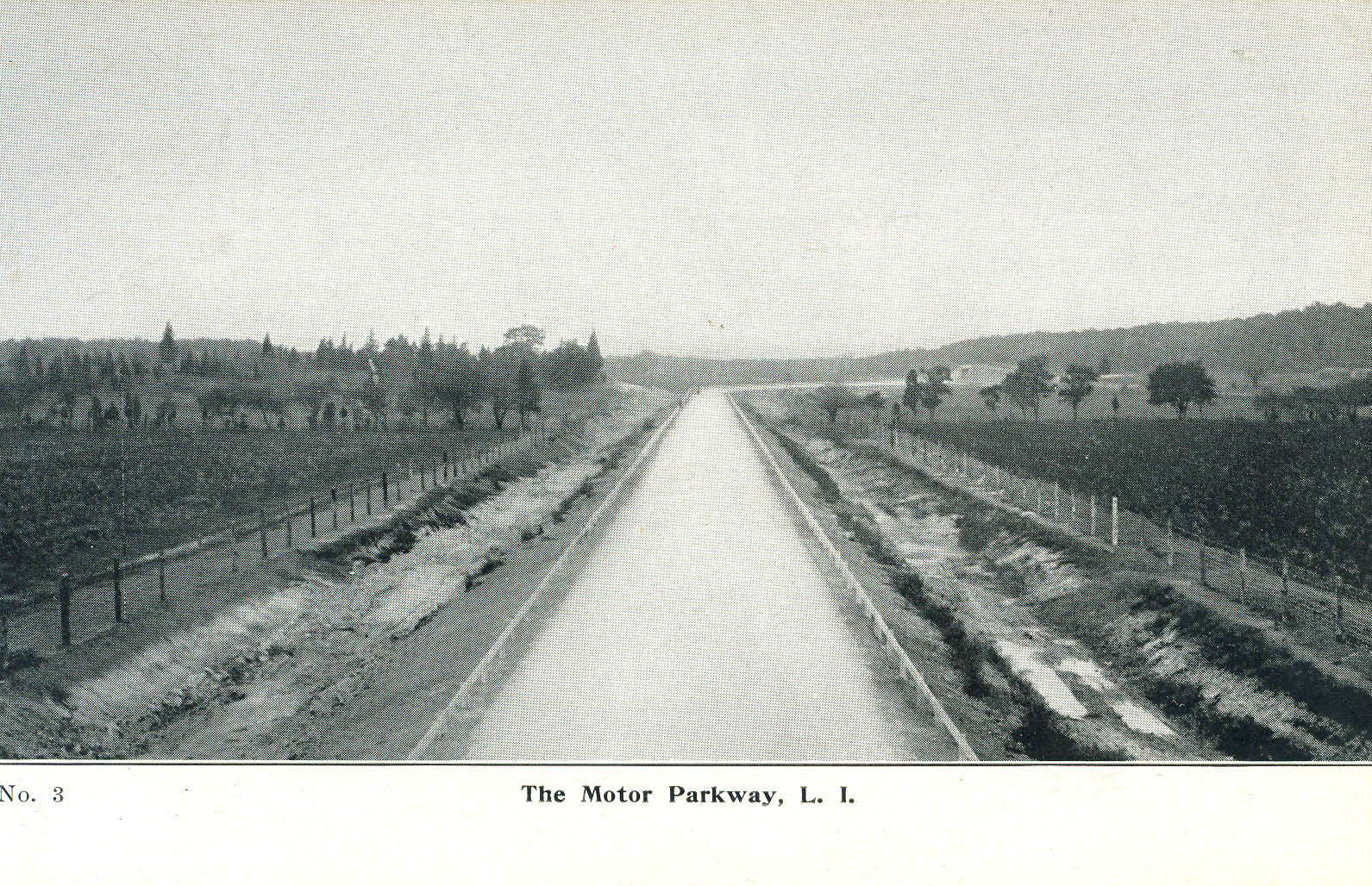
Photographer stands atop the Powell’s Avenue Bridge. Looking North. We see the LIMP turn east and pass under the Plainview Rd LIMP bridge. If you redid this picture today, you would be on the Powell’s Avenue bridge over Rt 135 looking north. We know this picture is old. Because of the wood poles used to fence in the parkway. They would eventually be replaced by cement posts.
That looks like the stretch of parkway along the north side of Col. Wetmueller’s estate on the border of Nassau and Suffolk County. Wetmueller, like many of that class at he time, had a thoroughbred horse stable that produced the Sire of the 1911 Kentucky Derby winner (Meridian). He was a partner with Beula Lousie Henry who invented the vacuum ice cream maker and a high -speed sewing machine that required little pumping. I believe he was also a member of the South side Sportsman’s Club which later became Connetquot State Park, winning the prize for the largest Trout caught in the 1912 fish-fry.
We are looking north in Central Park (today’s Bethpage). Since the photographer appears to be slighly elevated, I believe he is on top of the Powell Avenue bridge with the Plainview Road bridge in the distance, right of center, just east of the curve. The two races that used this section of the LIMP were the 1908 Vanderbilt Cup Race and the 1908 Motor Parkway Sweepstakes.
Where was this stretch of the Parkway?
Bethpage north of dead man’s curve
Exact location and orientation of the photographer
Atop the Powell Avenue Highway Bridge Underpass
Any Motor Parkway structures in the photo
The Plainview Road Highway Bridge Underpass
What 2 races used this portion of the Parkway?
From the published (here) maps these would 1908 and 1909 or 1910
(unclear, as both races link to the same map).
Bethpage Park, formerly Central Park, looking north from atop the Powell Ave bridge. The Motor Pkwy here is now occupied by the southbound lane of the Seaford-Oyster Bay Expwy, Rt 135. The Plainview Rd highway bridge can be seen in the distance just after Motor Pkwy’s right turn into the park. The 1908 Motor Pkwy Sweepstakes Race and the 1908 Vanderbilt Cup Race had cars roaring down this stretch.
Online map
I thought along this particular stretch the old right of way of the former LIMP was under the power lines that run parallel to the 135 on the west side of the expressway. And when the power lines curve to the east over the expressway that’s where the LIMP would’ve curved to where Plainview rd used to be. Is that not accurate?
Hi David, it is true that the power lines follow the old RoW most of the time. Below are Rt 135 construction plans, including position of the Motor Pkwy, courtesy Art Kleiner.
David - some more including a 1950 aerial comparison, courtesy of the late Sam Berliner III.