Mystery Friday Foto #49 Solved: Traveling Along the Bucolic Motor Parkway in Bethpage
VanderbiltCupRaces.com reader Thomas Dziurka challenged you to identify this photo location taken in Bethpage.
Identify;
- Location and orientation of the photographer
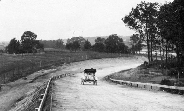
Coming down from the north side of the Central Ave./LIRR Motor Parkway bridge looking North in Bethpage (Central Park). (See Frank Femenias Google Earth image below)
- Approximate date
October, 1908
- Who owned the property on both sides of the parkway in the photo?
The Stymus Family farm property was at both sides of the parkway in the photo.
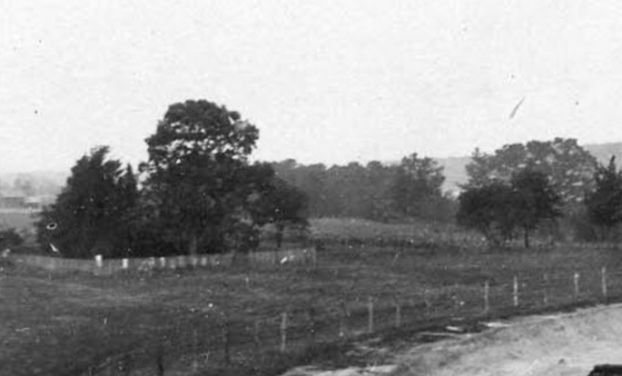
- What surrounds the cluster of trees on the left side of the photo?
The Stymus Family Cemetery.
- Kudos- Year and make of the automobile
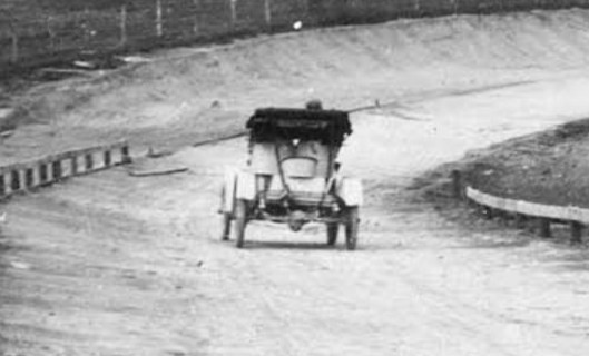
1908 Buick
For more on this photo and surrounding area; Mystery Foto #48 Solved: Building the Long Island Motor Parkway Through the Stymus Farm in Bethpage
Comments (6)
Congrats to Joseph Oesterle, Art Kleiner, Steve Lucas, Christopher Lindsley, Al Velocci, and Frank Femenias for identifying Bethpage (Central Park)
Greg O.

Close ups


Comments
Exiting the LIRR Bridge over Central Avenue in Bethpage. Heading north. The LIMP will turn east just a bit and follow the path of the current day Rt 135 North. I see the old cemetery straight ahead.
Looking north at the second Dead Man’s Curve in Bethpage (Central Park).
October, 1908
Joseph B. Botto (In 1906 the land was owned by Karp & Botto, pickle producers, who in 1908 offered to rent space for parking to viewers of the Vanderbilt Cup Race).
Cemetery
Not sure of the make and year of the car, but I believe the driver is Al Velocci!
We are looking north or slightly northeast in Central Park (Bethpage) with the photographer’s back to the Central Ave. / LIRR Motor Parkway bridge around September, !908. William O. Stymus owned the property on both sides of the LIMP at this section with the Stymus family cemetery in the cluster of trees on the left. The car looks like a 1908 Buick Model 10.
I have 2 guesses, but based on the surroundings it looks like Bethpage in the current Bethpage state park as the road curves north. The photographer is looking south west and my era guess is the 1910’s. I think there’s a golf course to the south , lending credibility to my claim. The woods are whatever was there before BSP. It could be Deadmans Curve in Bethpage, but the curve would be more pronounced.
Greg, Believe the photographer is on the Central Ave,/ railroad bridge at Central Park/Bethpage looking northeast. Photo taken sometime shortly before the Vanderbilt Sweepstakes Race on Oct, 10, 1908 as the roadway is not yet paved. Much earth was moved around in this area in order to maximize the speed thru the curves.The property on both sides was owned by William O. Stymus. Among the trees on the right was a 7-11.
A fantastic Motor Parkway photo taken in Central Park (Bethpage Park today). A lucky driver (photographer’s assistant?) is traveling north on the parkway through Peter Nibbe’s farm. The auto had just crossed Motor Parkway’s longest bridge, the Central Ave/LIRR bridge (107 ft), and is descending north towards Dead Man’s Curve #2 under Nibbe’s farmway bridge, another treacherous curve on the parkway. The red circle in the map is where the auto was positioned. Peter Nibbe would eventually be buried in the same family cemetery seen in the 1908 photo. Much thanks to Howard Kroplick’s research revealing Motor Parkway’s history on Long Island .