Mystery Friday Foto #30 Solved: A 1954 Photo of Nassau County Park at Salisbury Golf Course
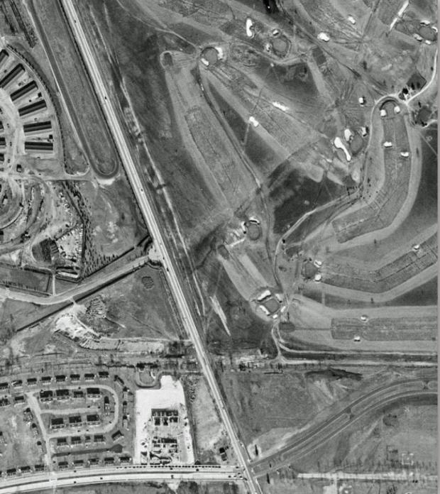
Did you identify the Nassau County Park at Salisbury Golf Course?
Identify;
- The golf course name during the operational years of the Motor Parkway, during the time of the photo, and what it is currently called
When the Motor Parkway was active: Salisbury Links and Salisbury Country Club
When the photo was taken: Nassau County Park at Salisbury. East Meadow residents just called it "Salisbury Park".
What it is called today: Eisenhower Park
- Year- provide a rationale
1954 based on the Stewart Avenue loop, the housing developments and the remnants of the Motor Parkway and Meadow Brook Lodge.
- Location and orientation
The aerial was photographed over the now current Eisenhower Park in East Meadow. Remnants of the Motor Parkway can be seen at the bottom of the aerial.
- All roads and possible Motor Parkway structures
The Meadow Brook Lodge can be seen still standing in the "keyhole" entrance west of Merrick Avenue. The Merrick Avenue Motor Parkway Bridge has been taken down in the 1940s. Merrick Avenue is shown running north/south. Stewart Avenue is shown in the bottom left and becomes Park Avenue while in the park.
Congrats to Joseph Oesterle, George Philippides, James King, Steve Lucas, Lee Chambers, Brian McCarthy, Ernie M, and Art Kleiner for identifying the East Meadow location and golf course. Kudos to Lee, Brian, and Art for the supporting documents.
Greg O.


Comments
Super easy. Saw it in seconds. The remnants of the Meadowbrook Lodge property gave it away. We are looking at Merrick Avenue. With Stewart Avenue at the bottom of the picture from the left to the center. Stewart used to continue through what is now Eisenhower Park. The golf course is part of Eisenhower Park today. Back then it was I believe the Salisbury Golf Club. I also see part of the old Mitchell Gardens. And part of the property to its north that was owned by the racetrack. You can barely see the ROW of the LIMP cross Merrick Ave about a third of the way up the picture.
The golf club is now called Eisenhower park. When the LIMP was running it was calledSalisbury Golf Club.
I believe this picture was taken in the late 40s-early 50s because the Merrick Avenue Bridge, taken down in the 40s is gone but the Meadowbrook lodge is still up ( came down in early 50s?)
Growing up in Garden City in the 60s we called it Salisbury park.
Picture is taken over East Meadow
Major roads include Stewart Avenue on bottom, left to right, ending at the entrance of the golf course- into what is now park Blvd.
Motor parkway is just north of Stewart running left to right.
Near Merrick Avenue ( north -south) you can see Meadowbrook lodge in keyhole driveway area.
Mystery photo #30
Formerly known as Salisbury Park. Now known as Eisenhower Park in East Meadow, NY. Merrick Avenue is shown running north/south. Stewart Avenue is shown in the bottom left and becomes Park Avenue when it crosses Merrick Av.
I’m thinking I’ve seen this photo before, so this is a memory test. When the LIMP was open, the golf course was Salisbury Links. As a kid growing up in the area, we called it Salisbury Park. Today it’s Eisenhower Park. I’m going to date it around mid 1950’s maybe 1954 or 1955 because you can still see the old right-of-way for the LIMP and what looks like the Meadowbrook Lodge and keyhole entrance drive. We are looking north over Westbury with the following roads visible: Stewart Avenue, Merrick Avenue and the drive through the park.
Salisbury Links, now Eisenhower Park. The County had already acquired the property as the winding road through the park had already been constructed.
Stewart Avenue runs left to right at the bottom of the photo (the remnants of the original route of the roadway through the Park ate still visible to the right of Merrick Ave. / Post Road).
Immediately to the North of Stewart Ave. is Mitchel Gardens, originally a WPA project for low ranking personnel at Mitchel Field which was later acquired by the Air Force. The site is now the recycling plant.
Barely visible above it is what was left of the LIMP and the Meadow Brook Lodge.
Still farther North, the stables at Roosevelt Raceway are visible.
To the right of that are the various golf links in the park. Part of the County park system since 1944, Salisbury Park was officially dedicated on October 1, 1949.
Click here to Download this file
This Aerial is viewed North in East Meadow & Westbury, NY. Just guess is 1954+, being that a 1953 Historic Aerial is a match. Don’t see the Meadowbrook Pkwy built up North to this location yet, believe it was 1956 +. The golf course was Nassau County Links & Park. now Eisenhower Park. LIMP is visible East & West of Merrick Ave. The Meadowbrook Lodge and Keyhole Entrance is seen, lodge became a home. Greg O. found that the lodge remained at least as late as 1957. Screenshots below are marked with roads etc.
The golf course name during the operational years of the Motor Parkway, during the time of the photo, and what it is currently called:
Originally the Salisbury Country Club, built by Joseph J. Lannin in 1917. His daughter Dorothy’s residence and carriage house (The Lannin House) still stands in Eisenhower Park south of the lake.
Year- provide a rationale:
Post LIMP closure as the Merrick Road overpass is gone. Salisbury Park was officially dedicated on October 1, 1949, and the main thru road is evident.
Location and orientation:
Looking generally north, Westbury
All roads and possible Motor Parkway structures:
Park Boulevard
Merrick Road
Meadow Brook Lodge and the entrance “keyhole” road.
Barns from the Roosevelt Raceway for harness racing.
“Salisbury Golf Club” during the 1930s, “Nassau County Park at Salisbury” in 1944, “Eisenhower Park Red Course” since 1969.
1954/1955 - structure just below the Motor Parkway lodge built in 1955 according to Nassau County Tax records. No Merrick Avenue Motor Parkway Bridge (taken down shortly after the Parkway closed in 1938).
West of Merrick Avenue, north of Stewart Avenue, Westbury
Merrick Avenue, Stewart Avenue, Park Blvd.
Meadowbrook Motor Parkway Lodge, Gate, entrance.
1937 ad for the Salisbury Golf Club - I suggest the next meeting of the LIMP Preservation Society be held there and we splurge for the $1.25 dinner!
Pics showing the location in 1926 and 1950 are from Nassau County Tax records.