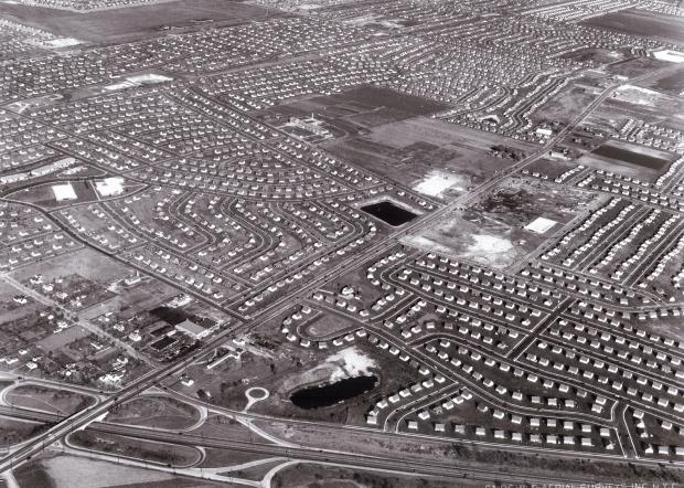
Mystery Friday Foto #25 Solved: A 1949 Fairchild Aerial Survey over Levittown
Did you solve last weekend's Mystery Foto?
Answers to the Mystery Foto questions:
Identify:
- The location and orientation of the photographer
Looking northeast over Levittown
- The major roads and buildings
Roads
-Wantagh State Parkway (across the bottom)
-Hempstead Turnpike (diagonally bottom left corner to top right corner)
-Division Avenue (across the middle with the Division Avenue High School)
-Long Island Motor Parkway (from top left corner)
-Jerusalem Avenue (third road from the top)
Buildings
-Long Island Aviation Country Club Clubhouse and Hangers (top left)
-Division Avenue High School) (middle)
- The date of the aerial
November 6, 1949
Link the Mystery Foto to the Motor Parkway.
The Motor Parkway can be seen in the left corner which was also part of the courses for the 1908, 1909 and 1910 Vanderbilt Cup Races. Hempstead Turnpike was part of the 1904 Vanderbilt Cup Race course.
Comments (9)
Congrats to Joe Oesterle, David Miller, Al Prete, John Cunningham, Mark Lanese, Steve Lucas, Frank Drebin, Art Kleiner and my favorite co-author Al Velocci for correctly identifying Levittown.
Kudos to Steve Lucas for linking this Mystery aerial to the coruses for the 1904, 1908, 1909 and 1910 Vanderbilt Cup Races.
Enjoy,
Howard Kroplick
Close-Ups
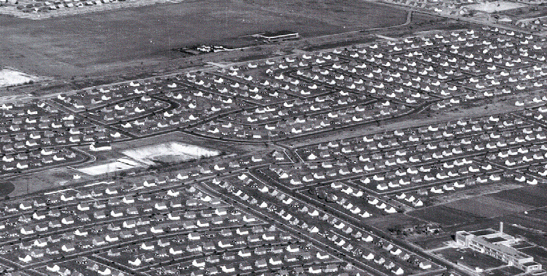
Long Island Aviation Club and Division Avenue High Scholl


Comments
Lower left in Wantagh Parkway heading L > R north to south
Hemp Tpke heading East
Remnants of LIMP near top
You can see old Airplane country club
This is a picture of Levittown. The photographer is facing northeast hovering over the Wantagh parkway which is at the bottom of the picture. Hempstead tpke runs from the bottom left to the top right of the photo. In the top left area of this picture the undeveloped land is the Long Island Aviation Country Club and has not yet been built over with Levitt homes when this picture was taken. The LIMP runs along the southern border of this property. Since some ranch style Levitt homes in this photo are shown as completed, (homes north of Orchid rd and east of Jerusalem ave) this picture should date around 1949.
The photographer is over Levittown, looking northeast. That’s the Wantagh State Parkway at the bottom, and Hempstead Turnpike is the straight road that cuts the diagonal from bottom left to top right. I see the Division Avenue School at top center. Motor Parkway ROW is at the extreme top left, and the Central Rail Road a few blocks south of that.
Photo must have been taken between 1948 and 1955, because the Division Avenue School does not have its north wing. It became a high school in 1955.
Ah, Levittown. Northwest over Levittown to be exact. Wantagh Parkway runs across the bottom of the photo. Hempstead Turnpike diagonally through the center. Motor Parkway across the top in front of the still existing aviation country club. Division Ave High School, the north village green, and the lot that would become the mays shopping center are all in the photo. The photo is 1948 based on the fact that division school is built(1948) but the aviation club has yet to become blacksmith lane. It closed in 1948. I suppose it could possibly early 1949 but no later.
Levittown. The photographer is facing northeast. The Wantagh Parkway runs along bottom of photo and Hempstead Tpke is running east/west. Division Ave High School is just above center of photo and Village Green is visible. This picture was probably taken sometime between 1949 and 1953. LIMP ROW is running east/west towards the top.
Looks like we’re over Levittown looking northeast towards Hicksville. Roads and buildings include Hempstead Turnpike, Wantagh Parkway, Jerusalem Avenue, the old right-of-way for the LIMP, Division Avenue and the High School of the same name. The Aviation Country Club can also be seen. I’ll estimate the date around 1955. The LIMP in this area was part of the course for the 1908, 1909, and 1910 V. C. Races. This section of Hempstead Turnpike was part of the 1904 Vanderbilt Race Course.
- Looks like East Meadow/Levittown border looking northeast.
- Looks like the Wantagh Parkway crossing over Hempstead Turnpike on the bottom.
- The white rectangle on the right might be the Bluegrass Lane pool. A little further up the Turnpike would be St. Bernard’s. The building in the top center of the photo would be Division Ave. High School. U-shaped street is Horseshoe Lane, so a little further up might be Dalton Funeral Home.
- By the look of the in-progress look of the high school, it would be around 1945-1947. The Levittown Baptist Church is visible too, so it might be 1947-1948.
Looking northeast over parts of Levittown and Island Trees.
Hempstead Turnpike, Wantagh Parkway, Division Avenue, Jerusalem Avenue, Orchard Road, Motor Parkway, Wolcott Road
Division High School, West Village Green, LI Aviation Club
1949-1950 - early Levittown showing minimal trees and shrub growth, church on Wolcott Road already built (1949), Division HS built (1948), LI Aviation Club still shown.
Similar aerial photo of the area is from the Nassau Tax Assessor’s website dated 1950.
At the bottom left of the photo are Hempstead Tpke. and the Wantagh State Parkway. Looking north east. Aviation Country Club at top left with the Motor Parkway ROW running along the southern boundary of the airfield.
i said northwest. i meant northeast. a bit late for that now, had i reread the pot before i typed i would have caught it.
Late to this Mystery, but here’s the Foto marked up.
Brian, thanks so much! Howard
No problem, Howard. I remember seeing a YouTube video of construction scenes in Levittown. Wonder if there’s any footage of The Bloomingdale Rd HWY being demolished? That would be neat to see!
The photo was taken on my mom’s 20th birthday!
The school was known as the Division Avenue School at the time. The high school grades came later. The Class of 1960 was the first class to graduate from Division Avenue High School.
Levitt & Sons bought the Long Island Aviation Country Club’s property in March 1950 for $175,000. Workers started staking 60’ x 100’ plots the following month, according to a Newsday article.
The Levittown Center shopping strip (think Mays) was built between 1950 and 1955. The first section (closest to Division Avenue) opened in June 1950. Mays opened 1955. We see the Kiessel family farmhouse roughly where Mays would later be.
We see the Green Acres housing development. Look at the north side of Hempstead Turnpike by Loring Road and Wolcott Road (a tad east of Wantagh Parkway). See how different a small group of houses in this area look compared to nearby Levitt cape cod houses? These are the Green Acres houses built by developer Herbert Gould in the mid-1930s. William Grac’s Green Nursery was on north side of the turnpike between Wantagh Parkway and Wolcott Road. We see it in this photo.
I’m a board member of the Levittown Historical Society.