Mystery Friday Foto #17 Solved: The Lone Newbridge Road Bridge Abutment in 1955
Motor Parkway historian Al Velocci challenged you to identify this lone bridge abutment left over from the Motor Parkway Newbridge Road Bridge in 1955.
Identify;
- The bridge this abutment originally belonged to
Newbridge Road 'Parkway' Bridge
- Location and streets in the photograph
- Orientation of the photographer
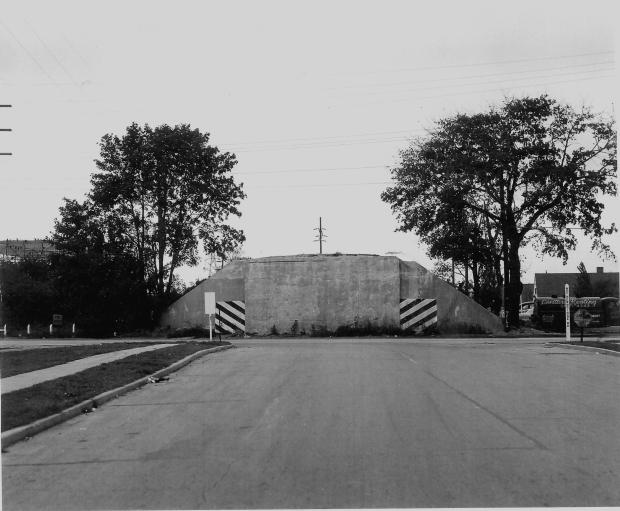
This 1955 photo was taken east of Newbridge Road in Levittown. The photographer was looking west towards the remaining abutment of the Newbridge Road Motor Parkway Bridge. The photographer is standing on Carnation Road looking west towards the Newbridge Road intersection. The abutment stood on the spot where Salisbury Park Drive will eventually terminate when completed. To the photographer's immediate left is now the site of the East Meadow Fire Department.
- Year the photograph was taken
October, 1955.
Comments (9)
Congrats to Al Prete, David Miller, Joseph Debono, Art Kleiner, George Philippides, Ernie M., Brian McCarthy and Frank Femenias for identifying the lone Newbridge Road bridge abutment.
Kudos to all who submitted supporting photos and also linking it to the 2019 mystery photo.
Greg O.

October, 1955.
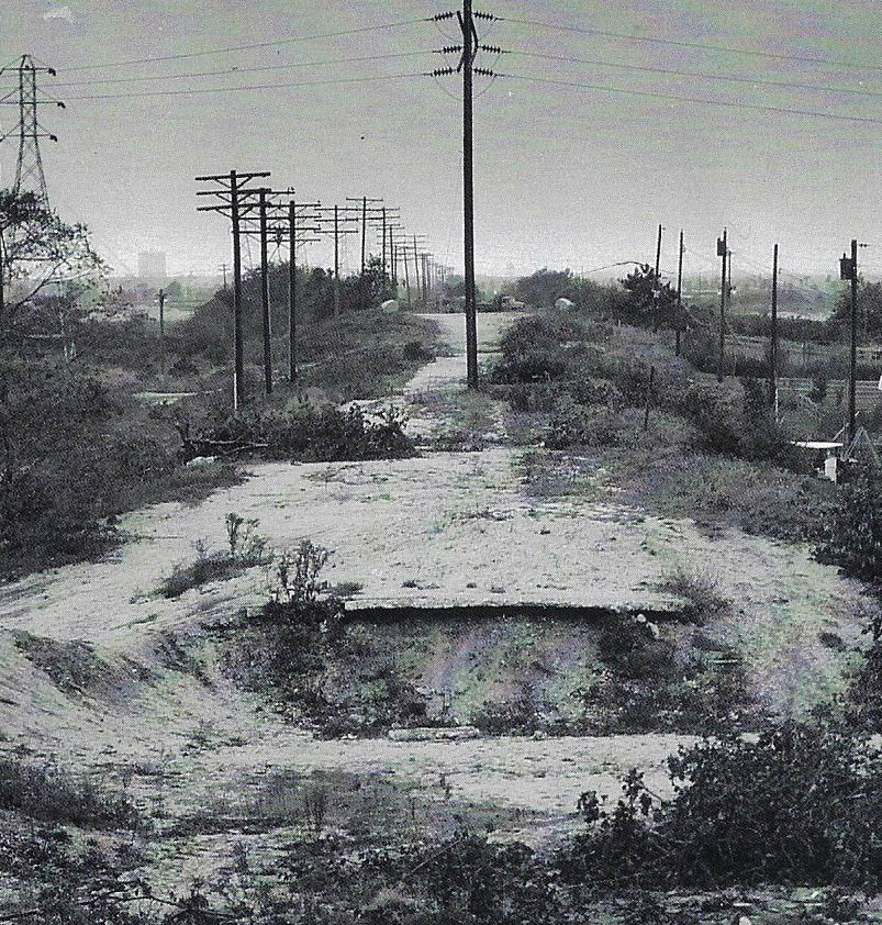
As many have pointed out, this previous 2019 mystery photo is the same view and orientation, but the photographer is standing on the top of the abutment showing what was behind it to the west. Note the same telephone pole in the center of both photos.
At the time of the previous mystery photo, it was believed that this photo was in 1956. Since we now have the original, captioned photo from Al Velocci, the date from that mystery photo post has been corrected to 1955.
Since both photos are together in Al Velocci's collection, with both dated October, 1955, we can assume that it is likely both photos were taken at the same time by the same photographer.
Why did this lone abutment stand for seven years after the original 1947 dismantling of the rest of the Newbridge Rd. Bridge?
Greg O.- This is pure speculation on my part, but my feeling is determined by the construction progress of the area. From 1997 to 2006, I lived in the Salisbury section of Westbury, directly north and west of this location near the intersection of Stewart and Carmen Avenues. My old house, along with most of that Salisbury neighborhood was built in 1954. Before my house and neighborhood were built in the mid-50's, there may have not been a reason for that section of the Motor Parkway, (on the north edge of Eisenhower Park), to be transformed into Salisbury Park Drive just yet, nor any reason to remove that western abutment since they were very difficult to demolish. Once my old neighborhood was built, they needed more roads into, and out of the Salisbury section, along with a widening of Newbridge Road to accommodate the new influx of traffic into the area, hence, they kept the western abutment intact from 1947 to 1955. Again, speculation on my part and not fact, to be clear. If anyone would like to add to this, please feel free.
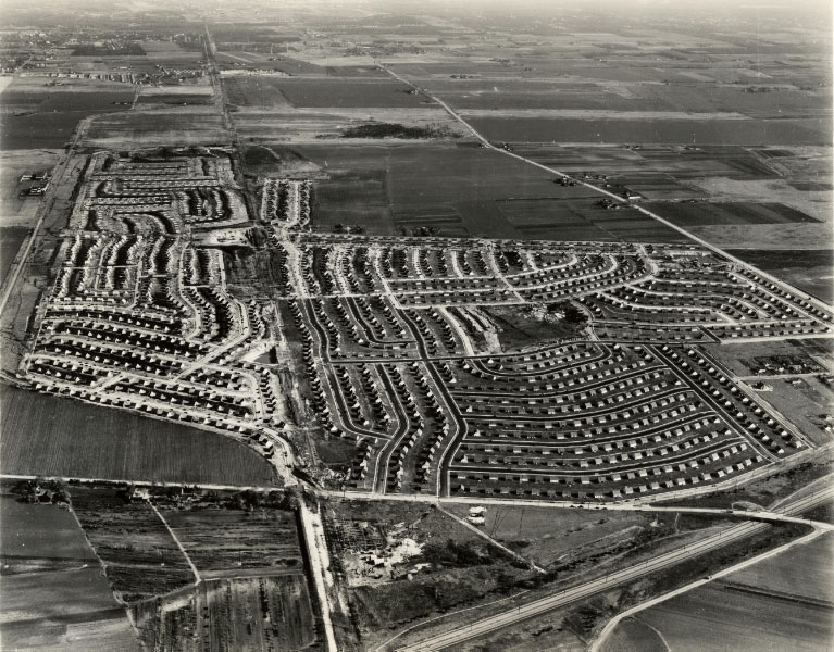
In this late 1947 aerial, we see the Levittown progress in the 6 moths since the beginning of the development. There are no houses yet in the Salisbury section of Westbury in the extreme lower left corner of the photo.
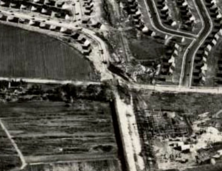
This closeup shows the dismantling of the Motor Parkway Newbridge Road bridge, but unfortunately we cannot make out that the western abutment is still present. It has been assumed all along, previous to this weekend's mystery photo, that the entire bridge was removed, but apparently that was not the case.
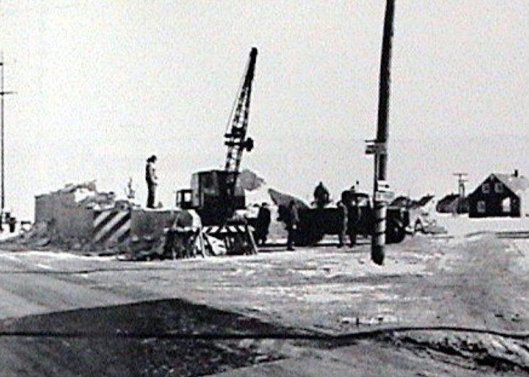
A ground level view of the eastern abutment being removed. This location is the exact spot the photographer of this weekend's mystery photo stood to achieve this weekend's 1955 photo.
Note the matching safety striping on the abutment.
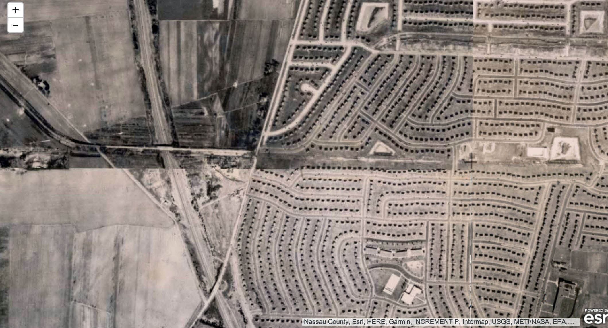
1950- The Newbridge Road Motor Parkway Bridge had been taken down. Salisbury Park Drive had still not been built, nor had construction begun on the Salisbury, Westbury neighborhood to the west of Newbridge Road.
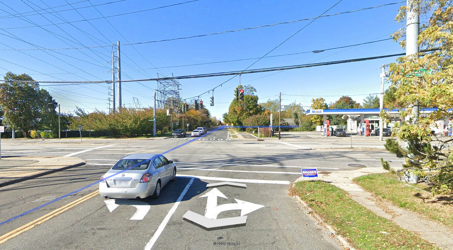
Here is the exact location and orientation on Carnation as seen currently in Google Earth.


Comments
The signpost gives away that the street at the top of the T-intersection is N. Newbridge Rd. (I grew up in the Town of Hempstead and am old enough to remember that style of street sign.) So the photographer must be on Salisbury Park Drive, facing where Carnation Road was going to be. Guessing circa 1950.
This looks like the Newbridge road bridge abutment in Levittown. Photographer is standing on Carnation road looking west. The bridge was taken down 1948-49. Newbridge road wasn’t widened until the bridge was completely taken down. So for a little while the surrounding newly built side streets were actually a little wider than the old Newbridge road. Please post more pictures like these. This was an amazing find.
1- The Long Island Motor Parkway abutment
2- Levitown, Newbridge Road and Carnation Road
3- looking west next to the East Meadow fire department station 3 to the left and the Long Island power grid to the left looking west
4- The photograph was taken in the late 1940s early 1950s
Newbridge Road Bridge (sign post indicates N. Newbridge Road)
Levittown, corner of N. Newbridge Road and today’s Salisbury Park Drive.
Looking east
Approximately 1947
This was the Newbridge road parkway bridge with LIMP running over Newbridge
Location;Levittown On Newbridge Road and LIMP( near Carnation?) intersection facing West with Long Island Utility company on left and LILCO tower on left in back ground.
Year- guess is early 1950s as the houses in the Levittown area went up around 1948 I believe
Well there are so many obvious clues in this picture, like the North Newbridge sign, the Levittown Heating truck, and the LILCO sub station.
The bridge this abutment originally belonged to
Over North Newbridge overpass.
Location and streets in the photograph
Standing in the middle of Carnation Road near Newbridge Road
Orientation of the photographer
Looking west.
Year the photograph was taken
Levittown was built between 1947 and 1951. We can see a Levitt west of
Newbridge so this is towards the latter date. I wish I had more details saved on
the timeline of the build as I live half a mile from this location.
The east abutment probably came down in ‘47 as Carnation was the only
egress to Newbridge at the time; the extension of Orchid came at a later phase.
There is what is my favorite LIMP picture of this bridge in Howard Kroplick’s
book “The Long Island Motor Parkway” It shows a racer jumping over this
bridge, in the background is the Nassau (Newbridge?) Hotel, and a railroad
crossing sign plus electric overhead from the Stewart Extension is also visible.
(The Pennsylvania Railroad used this extension to test various methods to
power electric trains for the NYC Pennsylvania Station and necessary tunnels.)
Real tough one, Al so it’s time for a couple of guesses. Is it possible we’re looking at a remnant of the Bloomingdale Road bridge, looking north, in the vicinity of Bloomingdale Road and Tiller Lane in Levittown? Maybe the date is around 1950.
If it wasn’t for the white wooden street sign at the right ( N Newbridge Rd ) this definitely would’ve been much harder to figure. Say this was taken from Carnation Rd, looking west across a then narrow N Newbridge Rd in Levittown. Above and to the left of the remaining abutment, I see framework with insulators. That’s the LILCO Electric Substation. Then there’s the LILCO transmission pole above in the middle. This image is similar to another image Al Velocci submitted in 2019. That image was determined 1956, so I’ll guess this current mystery is also 1956. But the 2019 image was taken after this abutment was knocked down, or maybe the photographer stood immediately west of the abutment. Up until now, LRV titles the road between Newbridge Rd and Old Westbury as Motor Pkwy. But we know it now as Salisbury Park Dr. Also notice the Fire House Sign, looks to be on the west side of Newbridge. I believe the Fire House was always on the east side of Newbridge.
Another amazing historic Motor Pkwy photo - one that I haven’t seen before. The street sign and fuel truck on the right gave away the location. I believe we’re looking west on newly-paved Carnation Rd in Levittown towards where the Motor Pkwy Newbridge Rd bridge once stood. All that remains in this photo is the west abutment wall. With the east wall removed, the west wall will follow suit sometime later for Salisbury Park Drive continuity. Appears an electrical supply station in the background on left side of the photo. The electric station remains today at the SW corner of Newbridge Rd and Salisbury Park Dr. Guessing this photo was taken after 1948 when the bridge was removed during Levittown development
A fantastic post I thoroughly enjoyed. Always thankful for history preserved by early photography. Thanks to all for making this happen!
Great mystery photo this week. Thanks Al for sharing the photo.
Greg - just a slight correction to where Salisbury is located. I also lived close to the mystery photo location, just west of Newbridge Road. However, the area is actually Levittown and was originally part of East Meadow until the Post Office moved my development (built in the mid-1950s) into the Levittown zip code. Salisbury actually borders the Wantagh Parkway on its east side. My area is directly west of Newbridge Road. Anything west of the parkway is Salisbury. Sorry to be so anal, but just as a researcher I try to be as accurate as possible. Thanks again, and keep those mystery photos coming.
In the mystery photo, note the Motor Pkwy abutment was aligned along the south side of Carnation Rd before curving north after passing the bridge