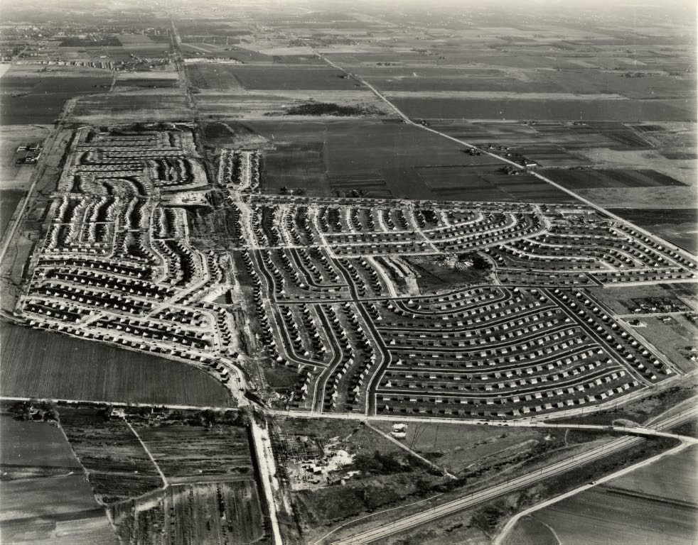
Mystery Friday Foto #12 Solved: A Levittown Aerial

Can you identify this Long Island aerial?
Identify:
- The location and orientation of the photographer
Looking east over Hempstead Plains/Levittown
- The Date; provide a rationale
November 13, 1947- The first phase of the Levittown development completed
- Identify any Motor Parkway structures and/or other identifiable structures
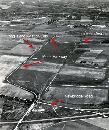
Newbridge Rd parkway Bridge had just been removed, Jerusalem Ave highway Bridge still there but removed shortly after the aerial, Bloomingdale Rd highway Bridge. The L.I. Aviation Country Club is on the left and also met its demise shortly thereafter. Structures beyond the Bloomingdale Bridge are too difficult to see.
- If any Motor Parkway structures, when were they removed?
All bridges within the immediate newly constructed Levittown developement had been taken down between 1947-1949
- Major roads
See below
Comments (5)
Congrats to Steve Lucas, Al Prete, Joseph Oesterle, David Miller and Frank Femenias for identifying the Levittown aerial.
Greg O.
Most major roads. The Wantagh Parkway going left to right at the very bottom.


Comments
We are looking east over today’s Levittown. The date should be around late 1947 since the first section new homes appears to be complete. Structures include L.I. Aviation Country Club, and the Newbridge Road, Jerusalem Ave. and Bloomingdale Road bridges. The Newbridge and Jerusalem bridges came down just about the same time as the photo with Bloomingdale about a year or two later. In addition to the LIMP remnants, other major roads include Hempstead Tpke., and Wantagh State Parkway.
The beginnings of Levittown. The photographer is looking east. It looks like the first phase of construction was completed, but there is still a lot of farmland surrounding it, so I’ll give the date as late 1947 or early 1948.
I see the Wantagh Parkway, North Bellmore Road, Newbridge Road, and Old Westbury Road at the lower right. Motor Parkway and the old Central Rail Road are at the lower middle. Motor Parkway also seen at extreme left, as it curved left towards the NE then right towards the E. Hempstead Turnpike at the upper right.
Two spots with no roads or houses would become the Azalea Road pool (the smaller spot), and the Village Green (the larger spot).
Levittown. Looking east. We see the LIMP in the center of the picture, having just crossed over the Wantagh Expressway on a bridge Rober Moses built. It bears north, skimming the edges of the new homes. Until coming back south at the far end of the picture. Sort of straight thru the middle of the picture is an old railroad right of way. The private flying club’s airfields and clubhouse still exist on the north side of the LIMP and can just be seen in the picture. My old eyes can’t seem to make out any parkway bridges still standing.
Looking east over Levittown. First phase, (tree section) completed but surrounding areas are still being built so it would be late 1947 or early 1948. Motor Parkway coming straight through the middle and then to left side past the LIACC going over and through Newbridge, Jerusalem, and Bloomingdale bridges. The Newbridge rd bridge was taken down by Nassau county around the time this picture was taken. The Jerusalem ave bridge was probably taken down in 1949. The expense was shared by both the state Nassau county. Soon after that, the Bloomingdale rd bridge was taken down by Levitt and Sons. Part of the Motor Parkway between Bloomingdale rd and Wantagh ave was acquired by Levitt for the construction of more homes in a “trade” with Nassau county. I’m sure the upside for the county in that trade was not having to deal with tearing down the Bloomingdale rd bridge.
The Levitt houses construction (1947-1951) in Levittown, NY - looking east in mid to late ‘40’s, with empty Wantagh Pkwy near completion. I see ruins of the Newbridge Rd parkway bridge (1908-1948), ruins of the Jerusalem Av highway bridge (1908-1948), Bloomingdale Rd highway bridge (1908-1948) appears intact, N Wantagh Av bridge (1908-1940s) - hard to tell its condition, Massapequa Lodge (1908-1967) is there but difficult to see. I’ll pinpoint this photo’s date sometime in 1948. LIACC Country Club airport and hangars (1929-1948) are visible, and just across the parkway was location of the former Grandstand during the 1908-1910 Vanderbilt Cup Races. Levitt would later expand housing in Levittown, PA (1952-1958), Willingboro Township, NJ (1958), and Levittown, Puerto Rico (1963). This photo also confirms location of the Motor Parkway’s RoW through the houses on the west side of today’s Carnation Rd
Major roads
I must have missed the submit button Sunday, here’s what I wrote:
The location and orientation of the photographer
High above Levittown, looking east
The Date; provide a rationale
1947, Phase I is complete, some 2,000 cape houses.
Note nothing is north of Orchid Road. These were build in the next Phase.
Also note Orchid does not continue onto Newbridge as it does today.
Identify any Motor Parkway structures and/or other identifiable structures
If any Motor Parkway structures, when were they removed?
The two overpasses were removed in 48, I cannot see if they are there in
this image. Pintail and Laurel Lane schools were built early on the ROW (after
this image), the remaining ROW was fairly intact until the 2000’s when major
sections were developed.
It made a good place for a kid to play.
Major roads
See image.
This was a really easy one for me as I have spent most of my life living in the circled house.
ErnieM - your red circle is pointing towards Poppy Lane in Levittown. That’s just one block from the Motor Pkwy! I agree living in the community this close to the historic parkway was a child’s exploration adventure! I wonder how far on the abandoned Motor Pkwy you were able to reach before hitting a dead end? That would be most interesting!