Long Island Motor Parkway
-
Nov 06 2018
Wednesday Meeting of the Long Island Motor Parkway Preservation Society on November 7, 2018
Please join us for another special evening providing an update on Motor Parkway projects and a return visit of author Richard Panchyk. Richard will be highlighting several of his new book Hidden History of Queens and his recent Mystery Foto aerials. (2 comments)
-
Nov 05 2018
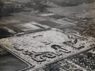
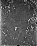
Mystery Foto #44 Solved: Glen Oaks Village Being Built Along the Motor Parkway Right-Of-Way in 1947
Steve Lucas challenged you again you to identify this aerial of a section of the Long Island right-of-way. (19 comments)
-
Oct 23 2018
Clinton Robertson Photo Album: Westbury Avenue Motor Parkway/Trolley Bridge in Mineola/Carle Place
In the first of the new series of photos from surveyor Clinton A. Robertson's recently discovered construction album, the unique Westbury Avenue Motor Parkway/Trolley Bridge on the border of Mineola and Carle Place is featured. (1 comments)
-
Oct 22 2018
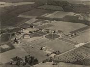
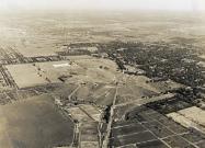
Mystery Foto #42 Solved: “Farmingdale State College” and the Long Island Motor Parkway in 1924
Richard Panchyk, the featured presenter at the November 7th meeting of the Long Island Motor Parkway Preservation Society, challenged you to solve another amazing Mystery Foto aerial. (15 comments)
-
Oct 20 2018
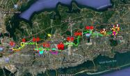
Femenias Findings: A New Interactive Online Map of the Long Island Motor Parkway
Inspired by Wayne Consolla's online Motor Parkway map, our master mapper Frank Femenias has created a new interactive online map of the Long Island Motor Parkway. (15 comments)
-
Oct 16 2018
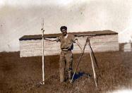
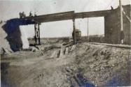
Exclusive: Surveyor Clinton Robertson’s Long Island Motor Parkway Construction Photo Album
While working as a surveyor on the Long Island Motor Parkway in 1908 and 1909, Clinton A. Robertson (above) documented the Motor Parkway construction and his fellow workers with his trusty camera. (14 comments)
-
Oct 09 2018
Updated: The 6th Annual “Motor Parkway Sunday Drive to Lake Ronkonkoma” A Big Success
Last Sunday's Motor Parkway Drive to commemorate the 110th Anniversary of the Long Island Motor Parkway was a great success. (3 comments)
-
Oct 02 2018
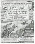
Celebrate the 110th Anniversary of the Long Island Motor Parkway on Sunday, October 7, 2018
Celebrate the 110th Anniversary of the Long Island Motor Parkway at the 6th Annual Motor Parkway Drive to Lake Ronkonkoma on Sunday, October 7, 2018. (13 comments)
-
Sep 24 2018
Mystery Foto #38 Solved: 1938 Aerial of Ronkonkoma and the Long Island Motor Parkway
Frank Femenias challenged you to identify this 1938 aerial courtesy of the University of Stony Brook. (9 comments)
-
Sep 17 2018
Mystery Foto #37 Solved: Cherry Valley Club, Garden City Hotel & Roosevelt Field in 1936
Author Richard Panchyk challenged you again to find the Motor Parkway and more in another classic aerial. (11 comments)

