Tag: Roosevelt%20raceway
-
Oct 20 2018
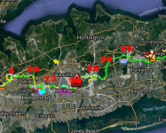
Femenias Findings: A New Interactive Online Map of the Long Island Motor Parkway
Inspired by Wayne Consolla's online Motor Parkway map, our master mapper Frank Femenias has created a new interactive online map of the Long Island Motor Parkway.
-
Jul 23 2018
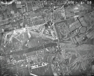
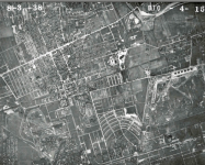
Update2:Mystery Foto #29 Solved:A 1936 Aerial of Mitchel Field,Roosevelt Raceway & the Motor Parkway
Author Richard Panchyk set a VanderbiltCupRaces.com record with back-to-back Mystery Foto challenges.
-
Jul 21 2018
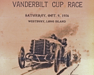
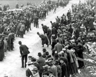
Helck Family Collection: Peter Helck Recalls the Greatest Vintage Car Event in Long Island’s History
Among the treasures discovered in the Helck Family Collection is an unedited 128-page biographical document written by Peter Helck. In the first post from these memoirs, Peter Helck recalls the 50th anniversary celebration of the 1904 Vanderbilt Cup Race held on Long Island.
-
May 07 2018
Mystery Foto#18 Solved:A 1951 View of the LIRR Motor Parkway Bridge from the New York State Archives
Frank Femenias challenged you to solve this weekend's Mystery Foto.
-
Mar 10 2018
The Impact of the Vanderbilt Cup Races: The Long Island Race Tracks
Sunday's new presentation in Westhampton will highlight the impact of the Vanderbilt Cup Races and the Motor Parkway on Long Island.
-
Jul 24 2017
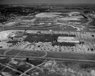
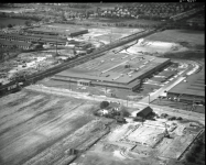
Mystery Foto #29 Solved: An Amazing Aerial of the Open-Air Roosevelt Field Center Circa 1961
The Cradle of Aviation Museum challenged you to identify this amazing aerial from their archives.
-
Mar 06 2017
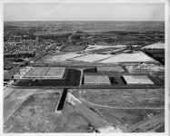
Mystery Foto #9 Solved: An Aerial Looking East Over Roosevelt Field. Circa 1952
The Cradle of Aviation Museum challenged you to solve this weekend's Mystery Foto.
-
Sep 10 2016
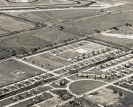
Femenias’ Findings: Anatomy of an Amazing 1938 Aerial (Garden City to East Meadow)
My favorite Nassau County aerial from the U.S. Department of Agriculture 1938 series highlighted the area from Garden City to East Meadow.
-
Jul 16 2016
The 1938 U.S. Department of Agriculture Aerial Suvey of Nassau County #2: Garden City to East Meadow
On August 3, 1938, the United States Department of Agriculture conducted an aerial survey of Nassau County. These enlargeable aerials (NC_8_3_38 series) have been posted on the Stony Brook University Digital Research Collections. Unfortunately, these aerials are not sorted, indexed by location and are combined with other aerials in the…
-
Jul 13 2016
The 1938 U.S. Department of Agriculture Aerial Suvey of Nassau County #1: Searingtown to Garden City
On August 3, 1938, the United States Department of Agriculture conducted an aerial survey of Nassau County. These enlargeable aerials (NC_8_3_38 series) have been posted on the Stony Brook University Digital Research Collections.


hi, how do you date the chassis of a car with the fedco plate? my fedco plate read
YYY EEE ZERO THRE ONE WWW, so the…