Part I: The Motor Parkway “Mayan Ruins” in Garden City
Art writes: "I recently came across what might have been remnants of a bridge that ran over the Motor Parkway in Garden City. Through a friend's suggestion who lives on Pell Terrace, I was able to visit and take some photos but I wonder if you have any information. as to whether it was ever built. I found a map from 1914 that shows the Parkway crossing what was then called "Mineola Road" which ran between Washington Ave. and Clinton Road in Garden City. I suspect that Mineola Road is actually today's Transverse Road that intersects Pell Terrace and which the bridge may have been built to connect the east and west sides. Any help would be appreciated. Thank you."
Art, you have come across one of the most fascinating recent discoveries associated with the Long Island Motor Parkway... the "Mayan Ruins" of Garden City. On Christmas Day, 2007, long-time Garden City resident Tony Carroll went for a walk near the Motor Parkway right-of-way when he noticed the above concrete wall near Transverse Road. Tony contacted my favorite co-author Al Velocci and inquired whether the wall was associated with the Motor Parkway. Al knew exactly what it was and then asked me if I had any further documentation of the "ruin". Here is what we found:

This is the 1907 survey of the Garden City land bought by the Motor Parkway from the heirs of A.T. Stewart through their Garden City Company. Note that the land owned by the Garden City Company was both east and west of the Motor Parkway. It was common practice that as part of the purchase agreement of divided land, the Long Island Motor Parkway, Inc. was required to build a bridge to connect the land or if a future cross-road was planned.
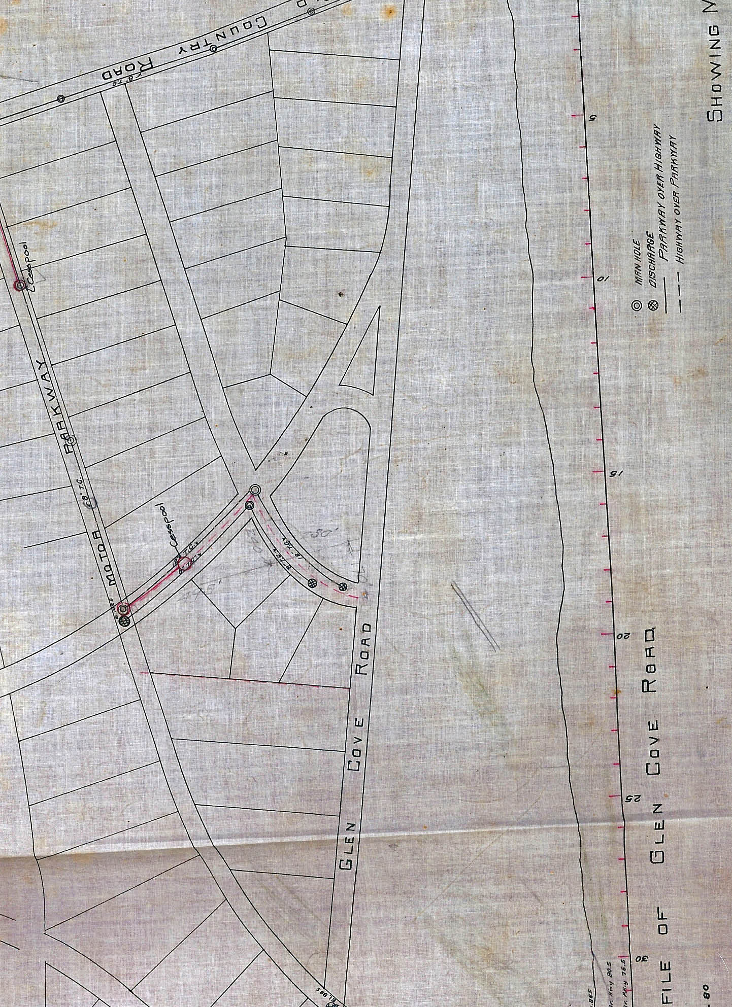
Indeed, this is a never before published survey of the proposed subdivision of the Garden City Company from my Motor Parkway Survey Collection. Note the planned road crossing the Motor Parkway in the middle of the survey (below Old Country Road to the north and Glen Cove Road (Clinton Road) to the south). Looks like a bridge would be needed if the road was ever built.
_edited-1.jpg)
Some 20 years after the original survey, this 1938 aerial shows the land east of the Motor Parkway (in the middle of the aerial) had still not been developed. Roads were just being built south of Old Country Road (the road on the top of the image) and west of the Motor Parkway.
_edited-2-1.jpg)
But, a closer look of the aerial reveals something else. What was this strange rectangular structure at the same location as the planned Garden City Company cross-road intersecting with the Motor Parkway? Tony knew Al Velocci would have the answer.

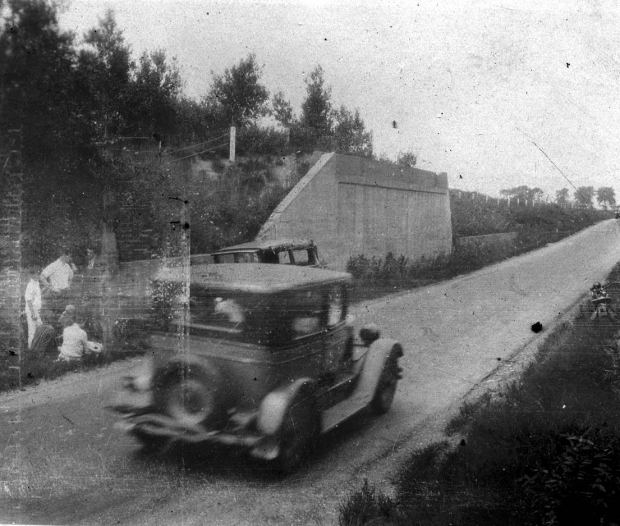
For years Al and I have been research volunteers at the Suffolk County Vanderbilt Museum. Al recalled finding a 1928 accident report and photos in the museum's archive of a car crash at the "open bridge". Looking north this is a photo of the accident scene courtesy of the Suffolk County Vanderbilt Museum. Note: The people at the accident scene on the left. The photo also shows that the road was clearly below grade at the accident scene with a bridge abutment and concrete posts lining the Motor Parkway.
_of_Top-4_10_edited-33-1.jpg)
This second image shows the opposite view looking south on the Motor Parkway. Eureka: There are two abutments of an unfinished bridge. Note the photographer's motorcycle on the left.
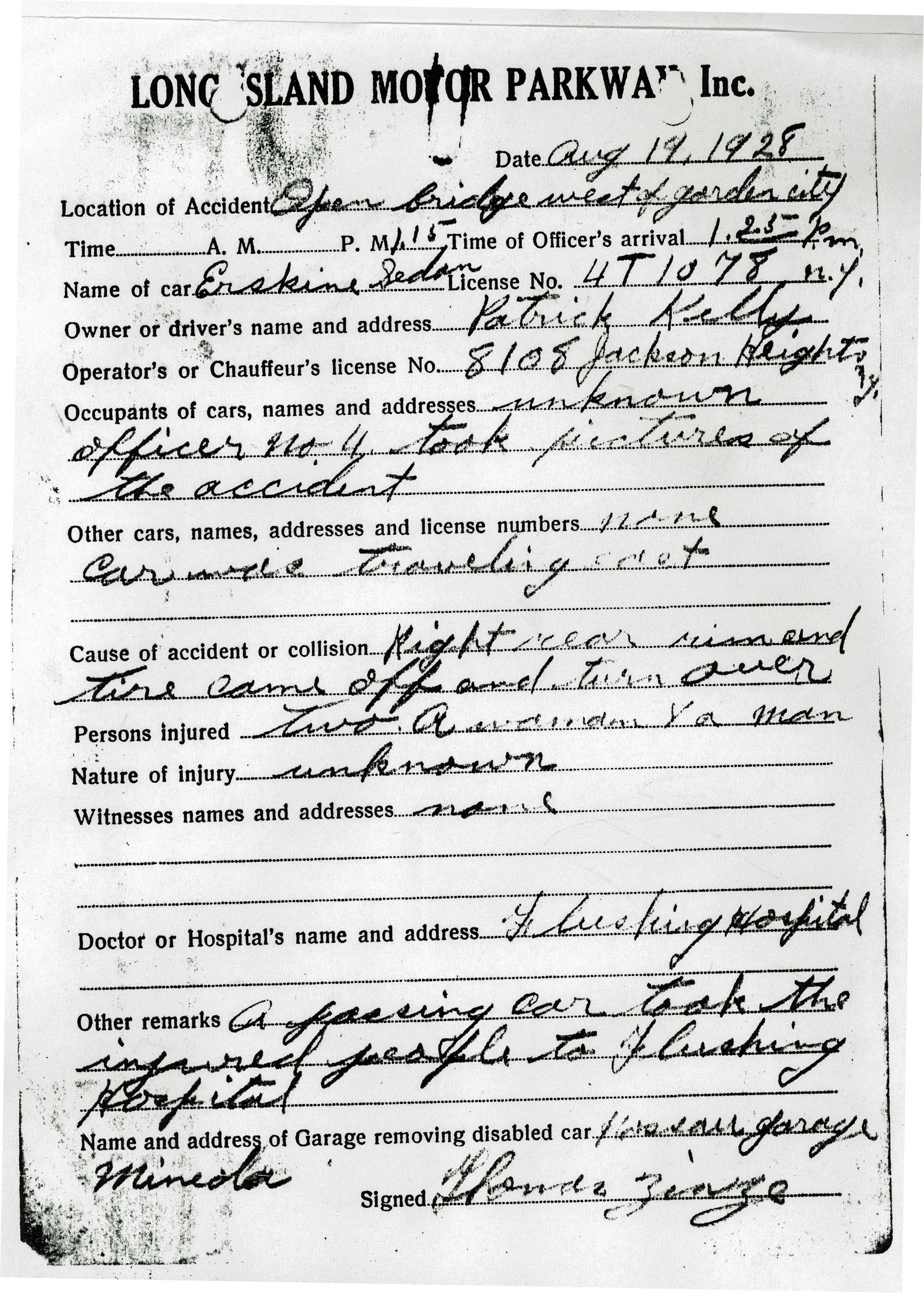
Click on this image and you will find the accident report that accompanied the photos. It documented that a car overturned at the "open bridge west of Garden City" on August 19, 1928 involving Patrick Kelly. His Erskine sedan lost a tire at the bridge and overturned. A passing car took Kelly and a woman passenger to Flushing Hospital to be treated for their unknown injuries. The report was written by Thomas Zinze who was a motorcycle patrolman for the Motor Parkway.
The story continues on Thursday with Part II: Then and Now: the "Mayan Ruins" of the Motor Parkway in Garden City.
Links to related posts on VanderbiltCupRaces.com:
Index: Long Island Motor Parkway
Long Island Motor Parkway-Nassau County
Great Neck Autofest Sets Record for Black Beast Drivers & Mechanicians


Comments
I’m guessing the cesspools on the old survey maps were for road drainage.No major sewer system back then.