Tag: Nassau County Dpw Maps & Surveys
-
Nov 19 2019
Kleiner’s Korner: Removal of the (Old) Westbury Road Motor Parkway Bridge in East Meadow
This next installment of my Motor Parkway bridge removal series takes us to the Westbury Road Bridge in East Meadow.
-
Nov 12 2019
Kleiner’s Kolumn: Revisiting the Transformation of the Motor Parkway into Salisbury Park Drive
Several comments to last month's Mystery Foto #43 (identification of the Motor Parkway west of Newbridge Road in Levittown) pertained to Salisbury Park Drive. Additional documents provided by the Nassau County Department of Public Works (NCDPW) uncover improvements to the Motor Parkway in this location and its incorporation into the…
-
Nov 06 2019
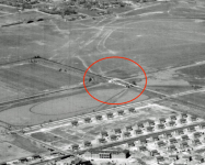
Kleiner’s Kolumn: Removal of the Roosevelt Field Motor Parkway Bridge
This installment of the series exploring the removal of Motor Parkway bridges documents plans from the Nassau County Department of Public Works pertaining to the Roosevelt Field Motor Parkway Bridge, connecting Stewart Avenue and Roosevelt Field.
-
Oct 29 2019
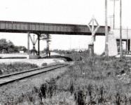
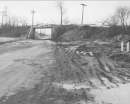
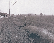
Kleiner’s Kolumn: Removal of the Central Avenue/LIRR Motor Parkway Bridge
Art Kleiner has explored recently obtained surveys and maps from the Nassau County Department of Public Works to focus on the removal of the largest bridge built for the Motor Parkway.
-
Oct 16 2019
Nassau County Department of Pubic Works Surveys and Maps: Closing the Motor Parkway
In a new Kleiner's Kolumn, Art Kleiner has obtained maps and surveys (1938-1968) from the Nassau County Department of Public Works detailing the plans for Motor Parkway after it closed in 1938.


hi, how do you date the chassis of a car with the fedco plate? my fedco plate read
YYY EEE ZERO THRE ONE WWW, so the…