Mystery Friday Photo #2 Solved: Clinton Road, Curtiss Field and the Curtiss Engineering Corporation
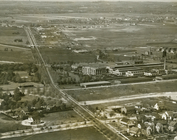
Last Friday's mystery photo has been solved. The aerial is looking north towards Curtiss Engineering Corporation and Curtiss Field in Garden City and East Garden City circa 1929. Clinton Road is running north and south highlighted by the Motor Parkway Bridge.
Congratulations to Joe Oesterle, Eric, Frank Scotty, Tim Ivers, Bob V., Brian McCarthy, Asguar, Lee, Martin Jablonski, Bellmer, Cyril Smith, Mark P., Susansmoose, Steve Lucas, Chris, Mitch Kaften, Bob Albertson, Greg O., and David Santee for correcting identifying the area.
Enjoy,
Howard Kroplick
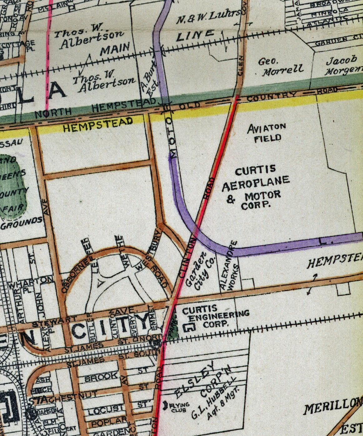
1923 Belcher-Hyde Map of the area
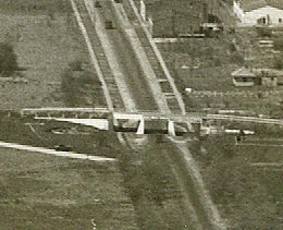
Clinton Avenue Motor Parkway Bridge
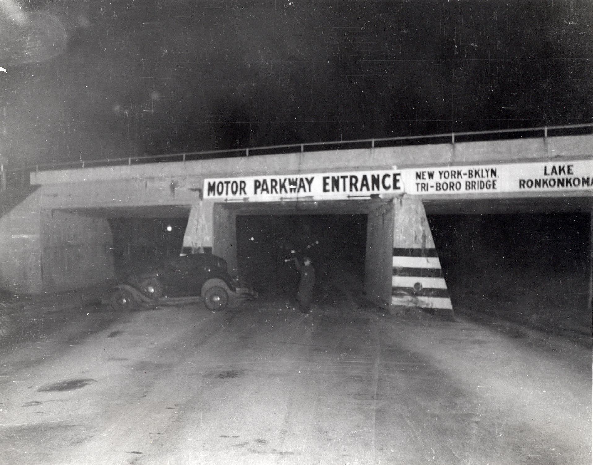
An accident scene at the Clinton Road Motor Parkway Bridge. Courtesy of Ron Ridolph.
Motor Parkway Office
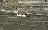
The first Motor Parkway office built in 1915 and in use until 1929.
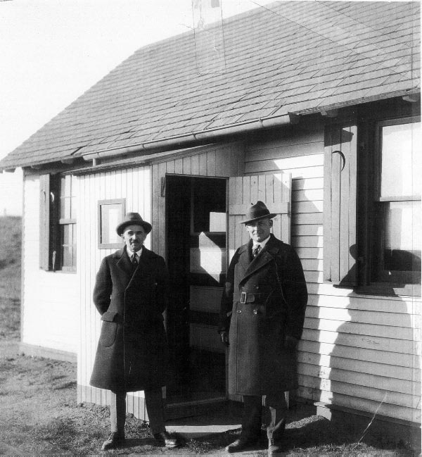
Arthur J. Kienzle, the parkway's general manager fom 1911 to 1928, with Arthur G. Archibald, the parkway's engineer from 1927 to 1938. Courtesy of Virginia MacMurray.
Garden City Lodge
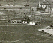
Elizabeth Ernst, wife of the toll collector, shown around 1935. Courtesy of Walter McCarthy.
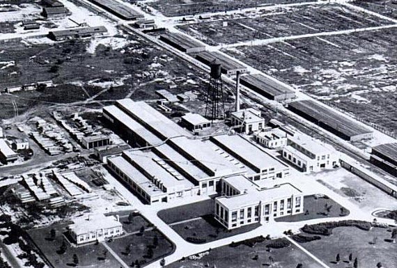
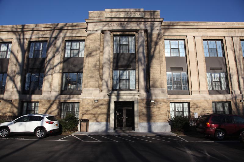
Curtiss Engineering Corporation
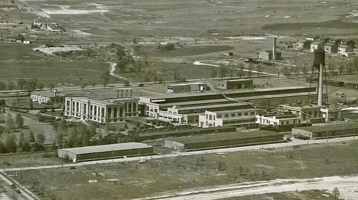
Built in 1918, Curtiss Engineering was the world's first facility completely dedicated to aviation research and development.
Update: February 23, 2013
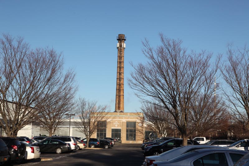
The Curtiss smoke stack from the original 1929 plant has survived with the name "Curtiss" faintly visible, and over the main entrance of the building, the name "Curtiss Engineering Corporation" remains.
Curtiss Field
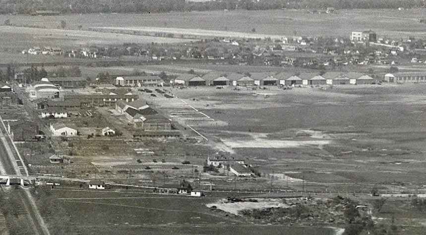
In 1917 when the US declared war on Germany, the Army converted a two year old National Guard Base , on the former site of Camp Black, to Hazelhurst Field. Named for Leighton Hazelhurst the first NCO killed in an aviation accident. Civilian aviation field after WWI. Renamed Curtis Field 1921-1929 and merged with adjacent Roosevelt Field and renamed Roosevelt Field 1929-1951. Closed 1951, for construction of first shopping mall in the US.
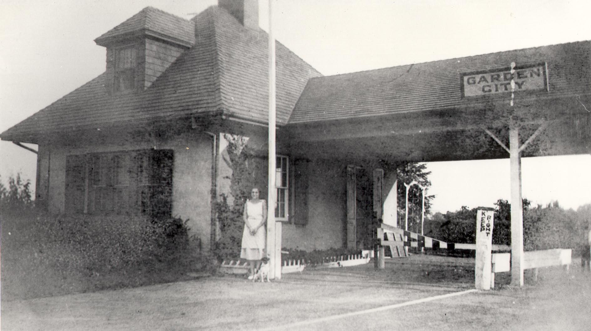
Clinton Road Station
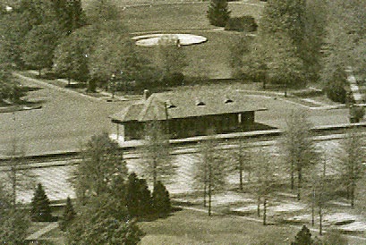
The Clinton Road Station was built sometime from 1911 to 1915.
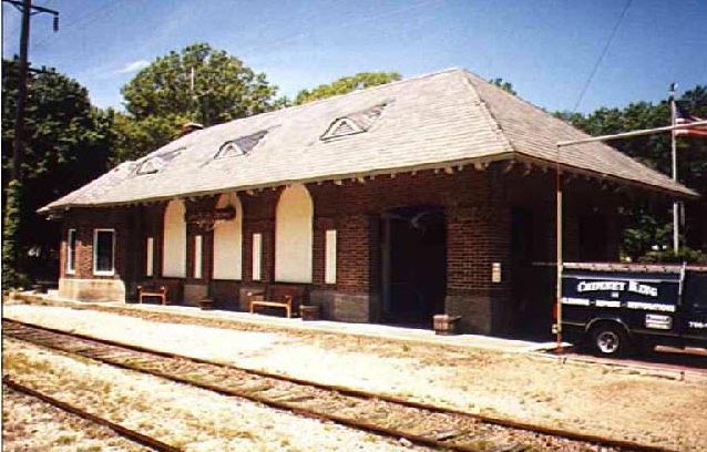
Then & Now

Then: 1929
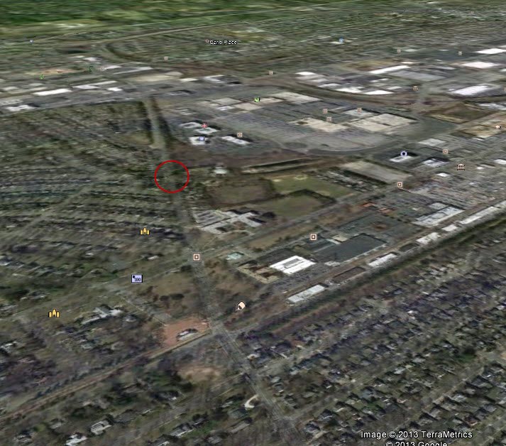
Now:Google Earth View of the Area Today


Comments
Clinton Ave looking North. Roosevelt Feild in back. Curtis Wright Factory in front.
LIMP crosses over Clinton Ave.
I believe this is looking north up Glen Cove/Clinton Rd. in Garden City. The Motor Parkway bridge crosses Clinton just south of Roosevelt Field. Stewart Ave. runs right through the center of the photo, parallel to the abandoned Mitchell Field LIRR line. The station building, left center, is used by the Garden City Fire Dept. and is still there. I’m not sure who occupied the factory. Looks like it was taken in the late ‘30s. Thanks for posting these!
The picture is in Garden City with the Curtiss factory in the front and Roosevelt Field in the background. Yearwise I would place sometime in the late 1930s. The Central Railrod line is the tracks.
P.S. Of course th Motor Parkway is there just left of center crossing over Clinton Avenue and the General Manager’s home and the Toll house right next to the overpass.
Garden City about 1940.
Looking north; large columned building in center is Curtiss Aircraft
Roadway (left to right) across bottom is Oak Street
Roadway (left to right) on top of Curtiss building is Stewart Avenue
Roadway running top to bottom on left is Clinton Road
Bridge over Clinton (near top) is LIMP bridge)
On right side of roadway at the bridge is toll house
Across top of photo is Roosevelt Flying Field.
Roadway (left to right) across top is Old Country Road
At lower left, across from Curtiss, is former rail station, later to be firehouse
EAST GARDEN CITY CLINTON ROAD ON LEFT, CURTISS AIRCRAFT IN CENTER, CURTISS FILD/ROOSEVELT FIELD AT TOP. NOTE MOTOR PARWAY CROSSING OVER CLINTON SOUTH OF AIRFIELD. DATE OF PIC BETWEEN 1922 AND 1951 PROBABLY AROUND 1940
Silly question. Is the limp in this photo?
I now see the limp bridge passing over Clinton rd in garden city.
I recognize the area,but can’t think of where it.,I’ve seen those buildings many times,don’t know whether it is Queens,Nassau or Suffolk. I’ll give it a try again when there’s some comments about it
My Error:
I am sorry about naming the street running left to right across the bottom as “Oak Street”. It is actually Commercial Avenue.
Cero wire
Curtiss Aircraft Factory with Curtiss Field in background?
Mitchel Field (aka Roosevelt Field) - Looking North
VP crosses East - West over bridge Glen Cove Road
Stewart Avenue East-West
Garden City / Central RR East West
howard good morning love the site always read it completely member of the li buick club. to answer the mystery pic it is a pic of roosevelt field looking north the street running through the pic from lower right to upper left is clinton rd and some of these houses in the pic stand today. the road on the lower left is chestnut st. just north of the tracks is an old train station that still exists but i believe is now used for a fire station, to the right just south of the tracks is comercial ave. and going north just past the large industrial bldg in the center of the pic is stewart ave and of course just north of that is the motor pkwy crossing over clinton, the right of way looks like it still exists today on the right and further north is old country rd with roosevelt field on the right of clinton south of old country rd. say hello to walt godsen for me thanks again for the great website
Facing NE along Clinton Rd. in Garden City to Roosevelt Field with the Motor Parkway crossing over Clinton. Curtiss Engineering plant at center right.
From Cyril Smith:
“View is north-northeast in Garden City. Factory is the Curtiss Engineering Plant, where Glen Curtiss “Father of Naval Aviation” built aircraft, including NC 4, the first plane to cross the Atlantic (May 1919), Just above the plant is Stewart Ave, then the Motor Parkway with its bridge spanning Clinton Road. LIMP running north-south to left of Clinton Road, the turning east-west.Beyond that is western end of Roosevelt Field / Hazelhurst Field.
In lower right hand corner is where Camp Mills 1917-19 existed, large deployment and training base of World War I. Some houses starting to appear, the warehouses just opposite Curtiss plant and across railroad, now little used freight spur, were originally for Camp Mills.”
The photo was taken in Spring of 1928.
wow, such an amazing, high-quality photo…at first i was going to ‘guess’ what it was but upon further inspection, growing up in Garden City and now living in Carle Place (on Garson Rd. right next to the LIPA right-of-way and down the road from where they are digging the pit where the Westbury ave. bridge was) i can clearly see Roosevelt Field, the Clinton Rd. LIMP bridge, the empty field that would become Stewart School, the old Garden City rail station that is now a Firehouse, the big empty field to the top/north of the photo that would become Carle Place (the original Levittown), the big courthouse-looking building that would later become Esselete and/or a Newsday location/train stop. i’m gonna guess 1925….wish i could zoom in on this photo…amazing…favorite pic so far….thanks…
I think this is clinton road in garden city, approximate time period would be the 30’s.
the big big building on the right i believe is the pendaflex paper factory..somewhere in that shot should be the garden city gatehouse for the Motor Parkway
The photo looks like Garden City about 1930. The view is looking north with Clinton Road running north / south in the middle. The large complex in the center is the Curtiss Airplane Factory with Roosevelt Field north of that with the hangars along Old Country Road. Motor Parkway crosses over Clinton Road about 2/3 of the way up on the left side.
Looks to me that its Clinton Ave. in Garden City, looking north towards Roosevelt Field. The train station with brick pavement is shown in the middle to lower left of picture. I even see a concrete fountain, just north of the station. Its still there, but is semi hidden now. I always wondered what it looked like originally.
Further north you can clearly see the bridge going over clinton, as well as the buildings.
Continued from my first response:
Oh, of course on the middle right is the Curtiss Engineering building, built in 1918.
And, the original train station was converted to GC fire Department Station no. 3. The Clinton Station opened in 1915.
My guess for date of photo is 1923
Clinton LIMP overpass into Roosevelt airfield. Don’t know the year, but I’d guess it was the 1920s.
We knew last week’s and we are guessing at this week’s. Garden City/Roosevelt Field circa 1938.
Great shot! That train station on St James still stands. Looking North on Clinton with the LIMP bridge, toll lodge and office and Roosevelt Field towards the top. Looks to be maybe 1928/9 ish?
I would say it looks like old Roosevelt Field in the background. If so then the bridge would be the Motor parkway crossing Clinton Rd.
Wowww! You guys certainlly know alot,it’s amazing,I had no idea of the area,but I’ve been around that area a lot of times and I know where it is now,thanks guys. Like I said once before,I’m new at this,I only realized where it was while I was reading all about it just now,Oh,that’s where it is,I kept saying to myself,then looking at the pictures. My uncle use to live around that area,I should have known it
L.W.F. ENGINERRING CORP OF COLLEGE POINT FIRST FACTORY ON LONG ISLAND CONSTRUCTED FOR THE SOLE PURPOSE OF BUILDING AIRCRAFT COMPLETED IN 1917.
I am a late-comer to this website and so too, is my comment about the photo looking north on Clinton Avenue, with the Curtiss Aircraft manufacturing plant the most prominent feature in the picture. There is a more significant feature to this photo, however. Hard to see in the distance, beyond the bridge and just to the east of Clinton Avenue, is a group of single-story buildings that includes the wooden hanger where Lindbergh parked his plane, the Spirit of St. Louis, the night before he took off for his historic non-stop flight to Paris in May, 1927. That hanger, essentially at the southeast corner of Clinton Avenue and Hempstead Turnpike, was actually part of Curtiss Field. Curtiss was directly west and adjacent to Roosevelt Field, whose boundary is delineated in the photo by the row of larger, concrete hangers running along the Turnpike at the top of the photo. On the day Lindbergh took off his plane was towed the short distance to Roosevelt Field. His departure was from west to east (left to right) in the photo. I grew up in Garden City and always wondered where exactly Lindbergh took off. To this day I don’t understand why the spot is not recognized with a historic marker.
A correction to my earlier post about Lindbergh’s presence in the photo of Curtiss and Roosevelt Fields: the hangers at the top of the photo run along Old Country Road, not Hempstead Turnpike.
My apologies.