Mystery Foto #9 Solved: Northern State Parkway and Wantagh State Parkway Under Construction

This weekend's Mystery Foto featured two Long Island parkways under construction and Roosevelt Raceway.
Mystery Foto questions:
- Where was the location of this aerial and its orientation?
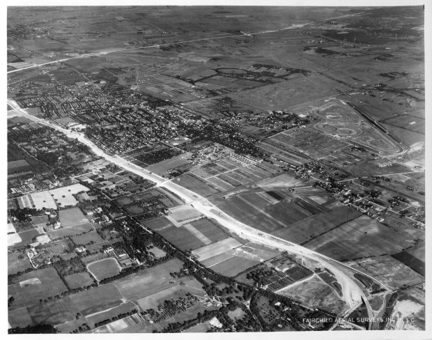
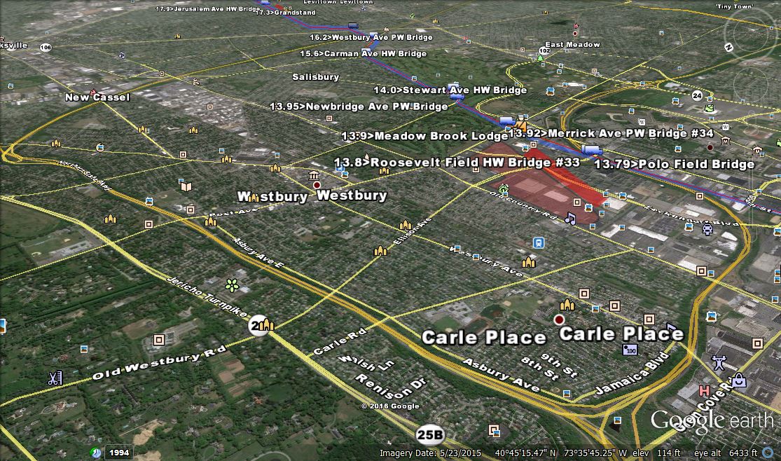
Airplane was over Old Westbury, looking south-east, Villages seen in the aerial are Old Westbury, Westbury, Carle Place, New Cassel, East Meadow, Salisbury, Hicksville and Levittown.
- Which Long Island parkway(s) were under construction?
Northern State Parkway Extension (bottom diagonal) and Wantagh State Parkway (top diagonal)
- Identify the Long Island Motor Parkway bridges and landmarks in the aerial?
Motor Parkway Bridges: Roosevelt Field, Merrick Avenue, Newbridge Avenue, Stewart Ave, Carmen Avenue, Westbury Ave, Wantagh State Parkway
Lodges: Meadow Brook Lodge in Westbruy
- What other Long island landmarks can be seen in the aerial?
Roosevelt Raceway with the midget racing track , Meadow Brook Polo Club Field , Salisbury Links and Ladenburg Estate. Many more landmarks are provided in the below Comments section.
- What is the estimated date of the aerial? Provide a rationale.
The official date on the photo was 1939 but it may be 1938.
Congrats to Michael LaBarbera, Steve Lucas, Brian McCarthy, Sam Berliner III, Art Kleiner (see Kleiner's Korner), Frank Femenias, and Greg O. (see Greg's Gold) for solving the Mystery Foto with great comments! Kudos to Art K. and Greg O. for their additional documentation. Always appreciated!
Enjoy,
Howard Kroplick
The Roosevelt Raceway midget racing track
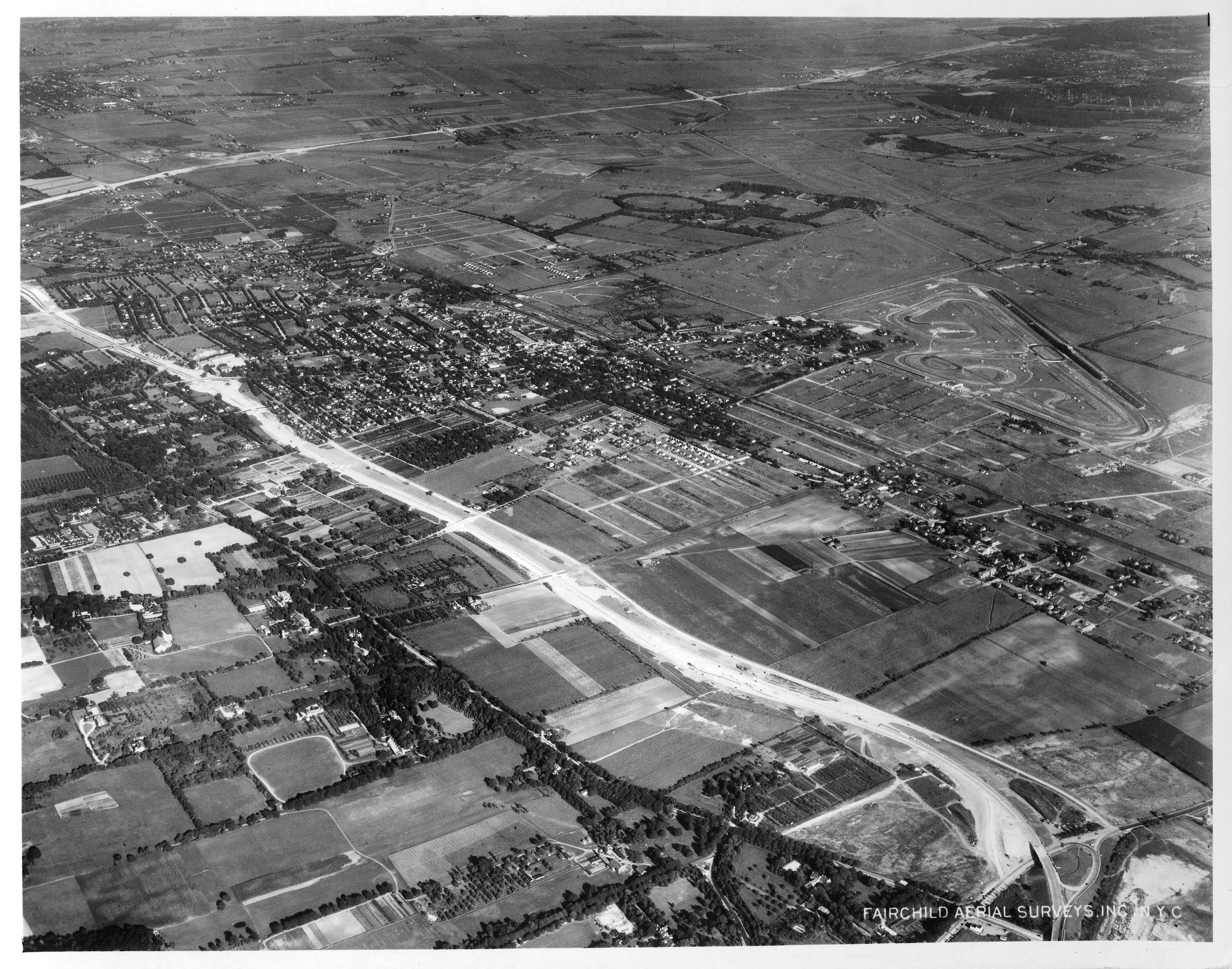
This 1939 view looking south-east shows Roosevelt Raceway in Westbury. The Northern State Parkway extension and was under construction.
Roosevelt field, Merrick Ave, Newbridge Ave, Stewart Ave, Carmen Ave, Westbury Ave, Wantagh Pkwy LIMP bridges.
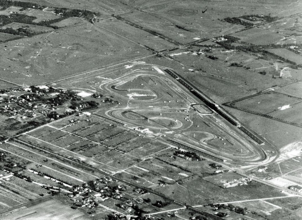
In the closeup of the aerial above, the oval track for midget races can be seen in front of the grandstands. At the south-east corner of the track is the Merrick Avenue Bridge and the Meadow Brook Lodge. Further east is the Newbridge Avenue Bridge in East Meadow.
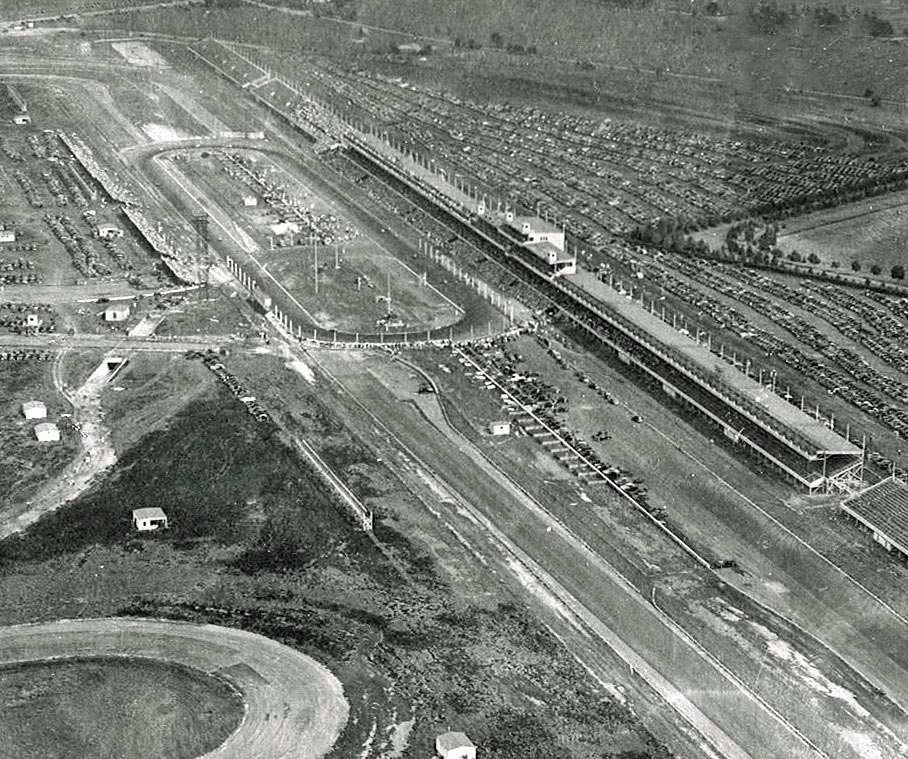
A closeup of the midget race track
Closeup
Greg's Gold (Submitted by Greg O.)
Kleiner's Korner (Submitted by Art Kleiner)
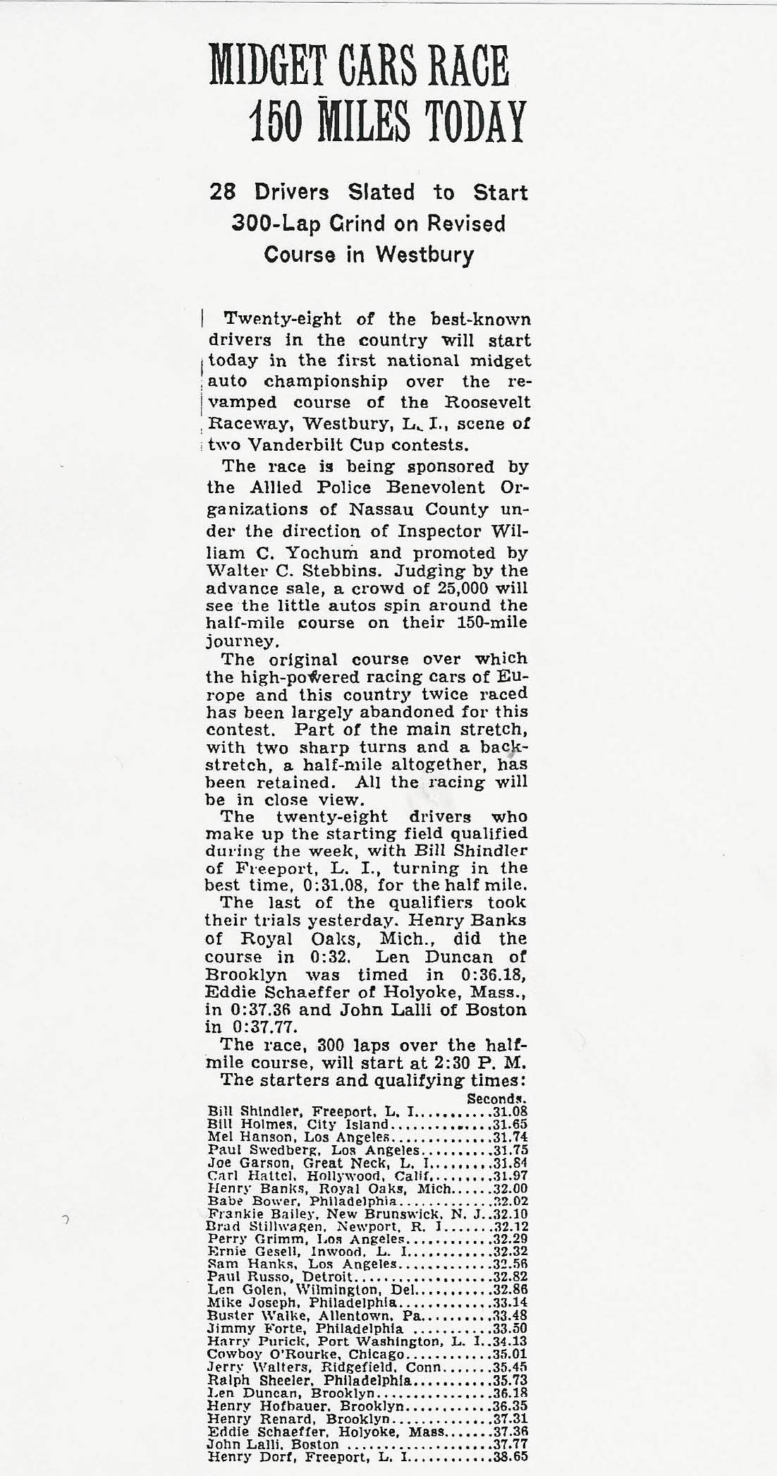
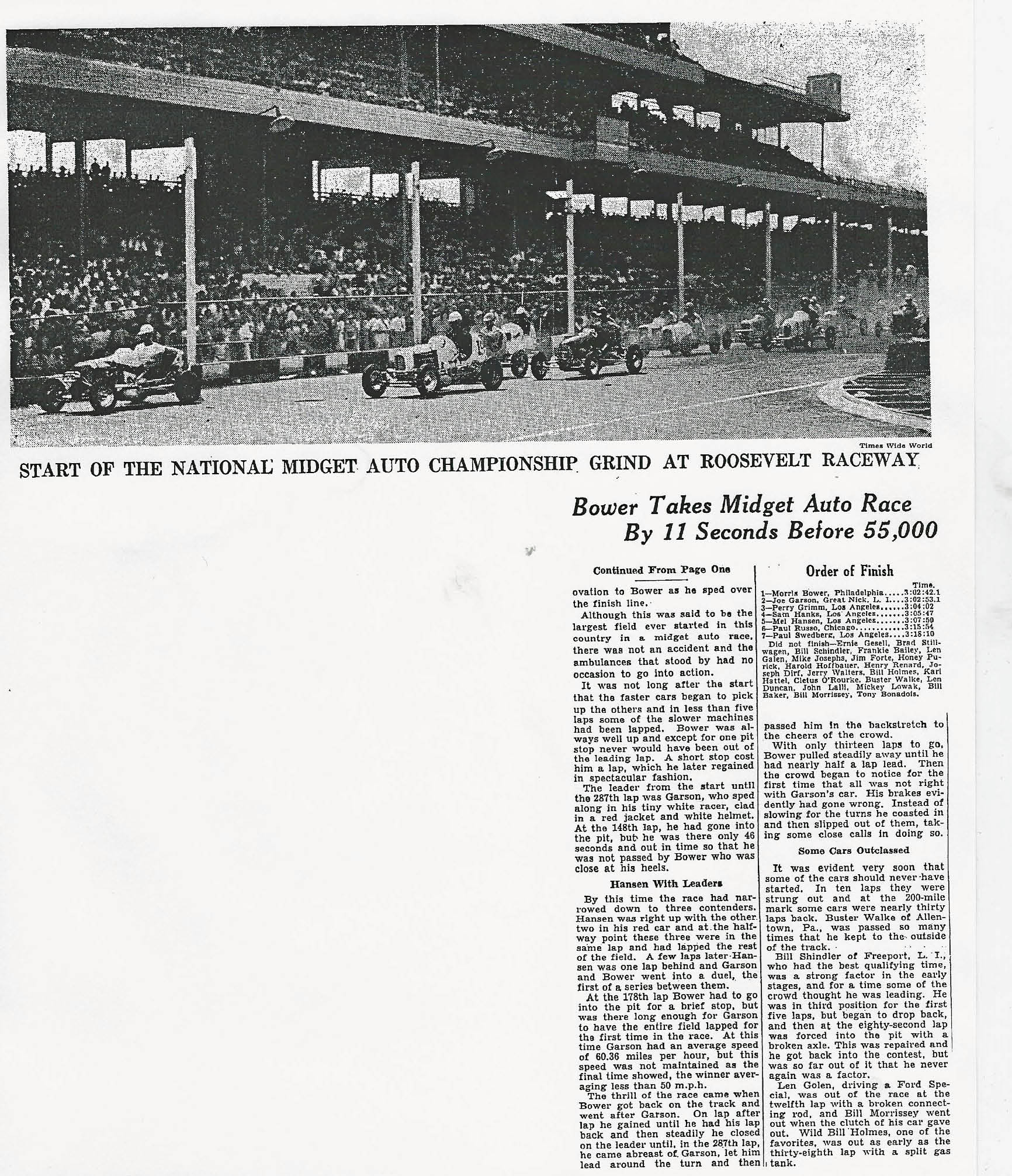
The New York Times, August 12, 1939
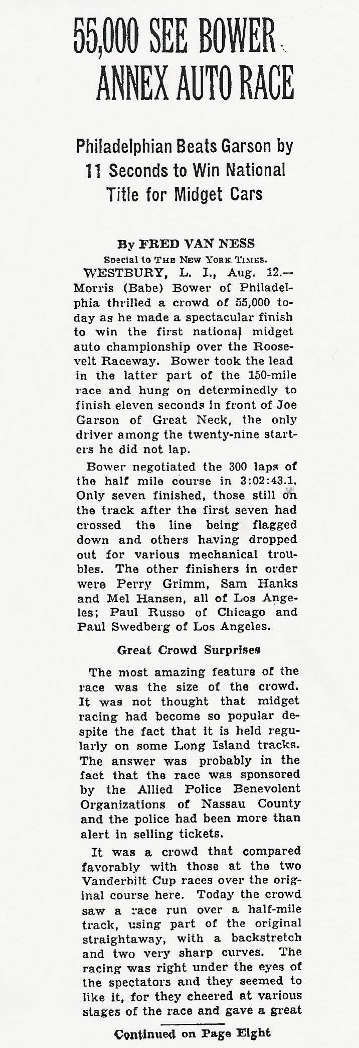
The New York Times, August 12, 1939


Comments
Ok here goes we are looking at the Northern Parkway intersecting with the Wantagh Parkway looking southeast from the Objectors Bend possibly down to the southern state. Due to the Race Track at Roosevelt Raceway the year is 1936. In this picture is the Motor Parkway over Ellison Avenue (Merchants Concourse), the Ladenburg Farm and the Newbridge (East Meadow Avenue) Bridge, Stewart Avenue conntcting with the Motor Parkway. North is St Brigid’s Church and the Holy Rood Cemetery. By Eisenhower Park is the Train Station and overpass over Meadwobrook Club Road, with the Salisbury Clubhouse before it was toxic. I cant seem to find the house from 1905 located in Eisenhower Park but it must be there. Hicksville is in the upper left corner. Looking carefully you can see the Motor Parkway Bridge over the Wantagh Parkway towards the upper middle of the picture and Hempstead Tpk in East Meadow and Levittown potato fields and possibly North Bellmore toward the top right. Middle right is the Meadowbrook Club and Polo Field. Across Merrick Avenue from that appears to be the swamp that they made into the Man made Lake at Eisenhower. Soooo much stuff to see in this picture and…..no i didnt need to look at the previous posts for help, im from this part o’ town.
The plane is flying over East Wiliston / Mineola with the camera pointed southeast toward Westbury & Carle Place. The parkway in the foreground is the Northern State with the Wantagh near the top. The LIMP bridges are (east to west) Roosevelt Field, Merrick Ave., Newbridge Ave., & Stewart Ave. along with the Meadowbrook Lodge. You can also see Roosevelt Raceway, Salisbury Links golf course, and the Meadowbrook Polo Fields. The date of the photo is probably sometime in 1938 since that section of the Northern State didn’t open until December 17th. of that year and the small midget car track is visable on the site of the Vanderbilt Cup Races held the two previous years.
Hello, history buffs. Just want to say I had partial assistance in my response to this mystery ( 4/16/11 Blog “Midget Auto Racing” )
Aerial location/Orientation: Overlooking Garden City, Westbury, East Meadow in a S/E direction.
Pkwys under construction: Wantagh Pkwy, definitely Northern State Pkwy.
LIMP data: Roosevelt field, Merrick Ave, Newbridge Ave, Stewart Ave, Carmen Ave, Westbury Ave, Wantagh Pkwy LIMP bridges.
Landmarks: Roosevelt raceway, Meadowbrook Polo Club, Clubhouse just opposite of Central RR, Salisbury Golf Club, Ladenburgh property. Mr. Kroplicks future childhood home.
Aerial date: 1939, time of the Midget Auto Racing and continuing construction of the Northern State Pkwy.
It would be neat to have a time machine for a day. This site and others are the next best thing.
Good mix of easy and hard! Location and orientation - over Hicksville looking WNW. Parkway(s) were under construction - No. State (upper right to upper left to lower right), Meadowbrook (far left), and Wantagh N. extension. LIMP bridges and landmarks - Roslyn Road and lodge, LIRR Main Line, Glen Cove Road and lodge and super’s house, Ellison Ave., Whaleneck Rd, Post Ave. at right - pass - too many! Other LI landmarks - endless - the Jericho Pike, ‘38 VCR course, Mitchel and Roos. Fields, Old Country Rd., LIRR Main Line, Hempstead Tpke. lower left, Meadowbrook Club and RR station, what was much later my house in Mineola, - - - AAAUUUGGGHHH! Estimated date - 1938 - when Wantagh was extended to No. State. WHEW! Sam, III
Nice mystery photo, Howard!
Where was the location of this aerial and its orientation
Looking southeast in Nassau County (Garden City, Westbury, Carle Place, East Meadow, Hempstead Plains)
Which Long Island parkway(s) were under construction?
Northern and Wantagh State Parkways
Identify the Long Island Motor Parkway bridges and landmarks in the aerial?
Meadow Brook Lodge, Merrick Ave. Parkway Bridge, Stewart Ave., Carmen Ave., Newbridge Ave., and possibly Old Country Road Bridges. And somewhere off to the east in the picture would be the Newbride Road bridge.
What other Long island landmarks can be seen in the aerial?
Salisbury Links, Roosevelt Field (including Midget race car track), Meadowbrook Polo Fields and Club House, Ladenberg estate, Meadowbrook Racetrack (now the location of the East Meadow School District Admin. Office), Central RR., James Cinch Smith estate.
What is the estimated date of the aerial? Provide a rationale. Note: Previous posting of this aerial has been removed until Monday night.
Contrary to other postings, I believe the date is 1937-1938, not 1939. According to newspaper clippings (Kleiner’s Korner) construction of this section of the Northern State Parkway was done in 1937 and 1938 with the official opening on Dec. 10, 1938. However, as I’ve noted before, you can’t believe everything you read! The Midget Car Races at Roosevelt Field was in August of 1939, and as the mystery picture shows the track, could the track not have been built soon before the race actually took place (say the spring of 1939) or maybe prior to 1939? Either way, close enough?
Love the crispy Fairchild aerials, they’re definitely ahead of their time. However Roosevelt Raceway gave this one away. Hard to hide that humongous structure. Facing SE at Carle Place/Westbury/E Garden City, around 1938 during construction of this section of Northern State Parkway (the white diagonal roadway in the foreground). The Wantagh State Pkwy may also be under construction as well (1927-1938, the white diagonal roadway in the background), also the first highway route to Jones Beach’s opening in 1929! The completed interchange of Meadowbrook State Pkwy will not appear here until 1956. The Long Island Motor Parkway in this photo is closed, or about to close (Apr 1938), due to Robert Moses’ fierce competition with a toll free highway system pictured here under construction
From Greg O.:
Did another fun, quick Google Earth screen capture. Always love the aerials!
• Where was the location of this aerial and its orientation?
• Just about opposite of the mystery photo from last week! Over Westbury looking South-West. Future Salisbury neighborhood of Westbury in the center near the top of the photo.
• Which Long Island parkway(s) were under construction?
• Northern and Wantagh State Parkways
• Identify the Long Island Motor Parkway bridges and landmarks in the aerial?
• Roosevelt Field Bridge, Meadowbrook lodge, Newbridge, Stewart and Carmen Ave bridges beyond that.
• What other Long island landmarks can be seen in the aerial?
• Roosevelt Raceway built for the 1936 & 1937 Vanderbilt Cup Races. The oval Roosevelt Raceway track for midget races can be seen in front of the grandstands. Looking closely I can make out the edge of the alee of trees from Phipps’ Westbury House ending at Jericho Tpke.
• What is the estimated date of the aerial? Provide a rationale.
• Spring/Summer 1939 since the parkways look just completed and there is plenty of foliage.