Mystery Foto #97 Solved: Rare Wooden Long Island Motor Parkway Sign (1933-1938)
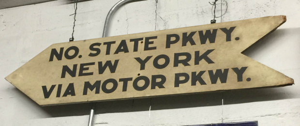
This weekend's Mystery Foto was a rare wooden parkway sign from the archives of the Society for the Preservation of Long Island Antiquities (SPLIA).
Answers to the Mystery Foto questions:
- What were the possible dates when this 3 feet x 1 1/2 feet sign was active? Hint: The sign's provenance stated the sign was from the 1930s.
From 1933 (the opening of Northern State Parkway in Nassau County) to Easter Day, Sunday April 17, 1938 (the closing of the Long Island Motor Parkway). The history of Northern State Parkway.
- Although the location of the sign is unknown, provide your best guess and rationale of where the sign was likely placed?
Several excellent guesses and rationales are posted below.
-Assuming a driver on the Motor Parkway followed this sign, what was the logical exit to reach Northern State Parkway?
From 1933- 1939, the logical Motor Parkway exits to reach the Northern State Parkway was either at JerichoTurnpike (Mineola Lodge) or Lakeville Road, Lake Success (Great Neck Lodge).
Congrats to Michael LaBarbera, Steve Lucas, Mitch Kahn, Greg O., Brian McCarthy, Art Kleiner, Gary Hammond, and Frank Femenias for information to shed light on this undocumented Motor Parkway sign.
Enjoy,
Howard Kroplick
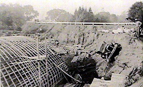
The Lakeville Road Bridge over Northern State Parkway being built in the 1930s. The Motor Parkway can be seen in the background. An automobile appraently fell into the construction area. Note the crane on the right.
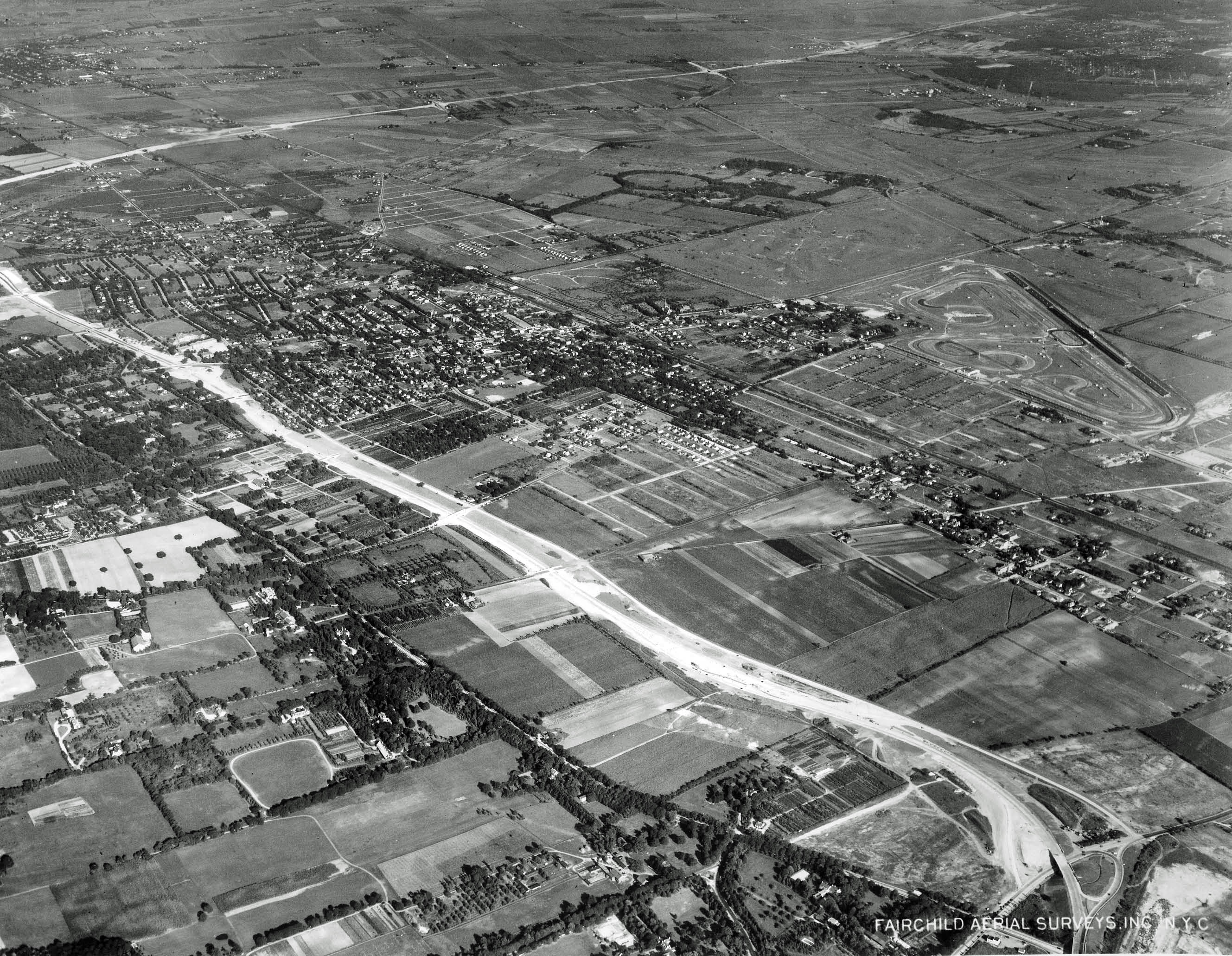
This 1939 aerial view looking south-west shows the construction of the Northern State Parkway and Wantagh State Parkway. If the date is accurate, the Northern State Parkway south of Jericho Turnpike had not yet been opened in 1939.
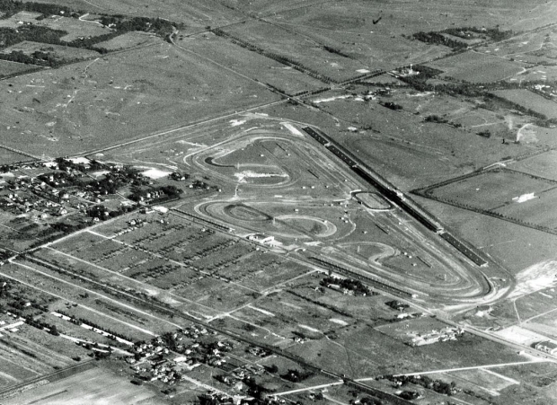
In this closeup of the aerial above, the oval Roosevelt Raceway track for midget races can be seen in front of the grandstands.
From Frank Femenias: "A toughy. This one may remain a mystery unless someone can recall seeing the sign back in the day. I shall make an attempt.
1934-1938
The sign indicating Northern Pkwy places it in Nassau or Suffolk county, not Queens. Because of its flimsy wire mount and emt electrical conduit behind, it is mounted on a small structure, possibly a house or booth, not a highway or bridge.
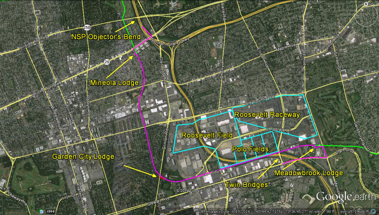
I believe it was used at a location where large volume of traffic was expected.The busiest place I can think of where the LIMP ran through is the Roosevelt Raceway/Polo Fields/Roosevelt Field area respectively. This sign may have been mounted on an entrance/exit booth to the Polo Fields or Roosevelt Raceway, to lure motorists onto the pricey LIMP to help avoid and alleviate traffic congestion on Old Country Rd and Stewart Ave. I suspect the intent was to cross the twin bridges (Polo Fields), work around to the Meadowbrook Lodge entrance on Merrick Ave, pay your toll!! (Perhaps at a discounted rate or free!!), travel westbound to the Mineola Lodge at Jericho Tpke and exit, then take a short hop eastward to the NSP ‘westbound only’ entrance via the Objector’s Bend section. The Meadowbrook Pkwy wasn’t around yet so accessing NSP west from the fun area for city dwellers was difficult pre WWII. Howard, I’m sending an attachment of this guess route and really looking forward to this week’s answers. This ought to be good. Thanks again.


Comments
My guess is at Lakeville Road (Where Marcus Avenue is) or the bridge east of that which also crosses the NSP.
Or it could be the terminus at Fresh Meadows Queens, for cars to continue on to New York City. But looking at the shiny pipe conduit behind it, this sign is hanging in a museum somewhere.
The first section of the Northern State Pkwy. opened in 1933 (from Grand Central Pkwy. to Willis Ave.) and the LIMP closed in 1938 so the sign could have been active only during that 5 year span. Trying to guess the possible location(s) of the sign requires a few assumptions be made: since it is advising drivers how to get TO New York, and it is telling drivers to make a left turn, it was probably intended for viewing by either northbound drivers on a north/south road or by westbound drivers on an east/west road. Since it implies access to both the NSP and LIMP by going in the same direction, I think we can also assume that entrances to both parkways would have been relatively near each other at that time. Following this logic, I think the sign was probably placed on the westbound side of Old Power House Road slightly east of the intersection with Roslyn Road. The NSP was only a few hundred feet south of this point and the LIMP Roslyn Toll Lodge was about a mile south. An argument could be made for similar placement at the intersection of Lakeville Road and Old Westbury Road but I don’t think so because it probably would have mentioned Grand Central Pkwy. While I don’t think the sign was used for LIMP drivers, it could logically have been placed at either the Great Neck, Roslyn, or Meadowbrook Lodges.
1. The NSP opened in 1933. The LIMP closed in 1938. That’s the window.
2. The sign could have been anywhere from Lake Ronkonkoma west to the Nassau/Suffolk line. One possible thought is Jericho Turnpike at Harned Road. Another is Sunrise Highway at Lakeland Avenue.
3. In ascending chronological order as the NSP was extended, Lakeville Road, Roslyn Road and then Jericho Turnpike (Mineola).
Addendum to my previous reply: the sign could have been at the intersection of Main St and Railroad Avenue in Sayville (Railroad becomes Lakeland as it heads northwest toward Lake Ronkonkoma and the LIMP).
- What were the possible dates when this 3 feet x 2 feet sign was active? Hint: The sign’s provenance stated the sign was from the 1930s.
Looking for a time when both roadways coexisted. The first section of the Northern State opened in 1933 and the Motor Parkway closed in April 1938 making that the possible time span.
- Although the location of the sign is unknown, provide your best guess and rationale of where the sign was likely placed?
Complete guess here, but maybe in Ronkonkoma to direct the traveler who was about to set off for a trip back to NYC.
-Assuming a driver on the Motor Parkway followed this sign, what was the logical exit to reach Northern State Parkway?
Another guess would be the Great Neck lodge on Lakeville road where they intesect.
Hello everyone. When viewing this sign, you’d think that there is a direct exit from the LIMP onto NSPkwy. And perhaps there was during the construction periods of the NSPkwy (1931 to 1938, where temporary on or off exits may have existed with an active LIMP). Since this sign location is unknown, I’d like to suggest 2 possible scenarios. Motoring east or west on the LIMP, I could exit off at Lakeville Rd; and then head a little south to NSPkwy. Or, motoring north or south on the LIMP, I could exit off at Jericho Tpke. And then head a little east to the NSPkwy. Now, I’m going to help my son with his homework.
This answer is pure guess except for the dates.
Date could be 1933 corresponding to the time when the Northern State reached Roslyn Road. Between this time and until 1934, there was no Northern State east of this as the wealthy land owners objected to its proposed route. Objectors’ Bend was built south at that point bypassing the estates and crossed Westbury and Carle Place before once again heading east.
Sign might have been at Glen Cove Road, directing motorists on the Motor Parkway to continue on the Parkway to get to the Northern State at a point later west to continue to New York.
Might the most logical exit be Roslyn Road?
First, the dimensions of the sign appear to be wrong - if it is 3 ft. long, then it isn’t 2 ft wide. Also is it 2-sided? It dates from c.1933-1938 - from when the NSP 1st opened to when the LIMP closed. As the sign shows no visible weathering it probably was protected under a bridge, etc., therefore single-sided, or dates from c. 1938. The 1935 SOCONY Long Island Road Map shows the NSP ending at Jericho Tpke & Glen Cove Rd (Guinea Woods Rd), about where it now meets the Meadowbrook Pkwy, which didn’t exist north of the Sunrise Hwy then. Logically then the sign would have to have been west of this spot in 1935, if it is from the earliest possible date. By 1938 the NSP finally reached the Wantagh Pwy, so if the sign is c.1938 then it could have been west of Wantagh Pkwy instead. Best I can do!
______________________________
From Howard Kroplick
Maybe 3 feet x 1 1/2 feet. Not sure if it is two-sided.
A toughy. This one may remain a mystery unless someone can recall seeing the sign back in the day. I shall make an attempt.
1934-1938
The sign indicating Northern Pkwy places it in Nassau or Suffolk county, not Queens.
Because of its flimsy wire mount and emt electrical conduit behind, it is mounted on a small structure, possibly a house or booth, not a highway or bridge.
I believe it was used at a location where large volume of traffic was expected.
The busiest place I can think of where the LIMP ran through is the Roosevelt Raceway/Polo Fields/Roosevelt Field area respectively.
This sign may have been mounted on an entrance/exit booth to the Polo Fields or Roosevelt Raceway, to lure motorists onto the pricey LIMP to help avoid and alleviate traffic congestion on Old Country Rd and Stewart Ave. I suspect the intent was to cross the twin bridges (Polo Fields), work around to the Meadowbrook Lodge entrance on Merrick Ave, pay your toll!! (Perhaps at a discounted rate or free!!), travel westbound to the Mineola Lodge at Jericho Tpke and exit, then take a short hop eastward to the NSP ‘westbound only’ entrance via the Objector’s Bend section. The Meadowbrook Pkwy wasn’t around yet so accessing NSP west from the fun area for city dwellers was difficult pre WWII. Howard, I’m sending an attachment of this guess route and really looking forward to this week’s answers. This ought to be good. Thanks again.
By the way, there is another sign hanging just below it in the same fashion.
Reading everyone’s comments before Howard puts up his comments, made me want to post up another possibility for the original placement of the sign. Maybe it was used near Roosevelt raceway during the 1936/37 Vanderbilt Cup Races…
Sorry, folks, but that sure looks like fresh concrete to me (you don’t get hairline cracks in wood) - thus a new Moses (NSP?) bridge abutment {?}. Sam, III
Your Fairchild Aerial Survey photo of Northern State Parkway under construction from its temporary terminus of Jericho tpk is earlier than 1939, since that strestch of Parkway was opened in Dec1938