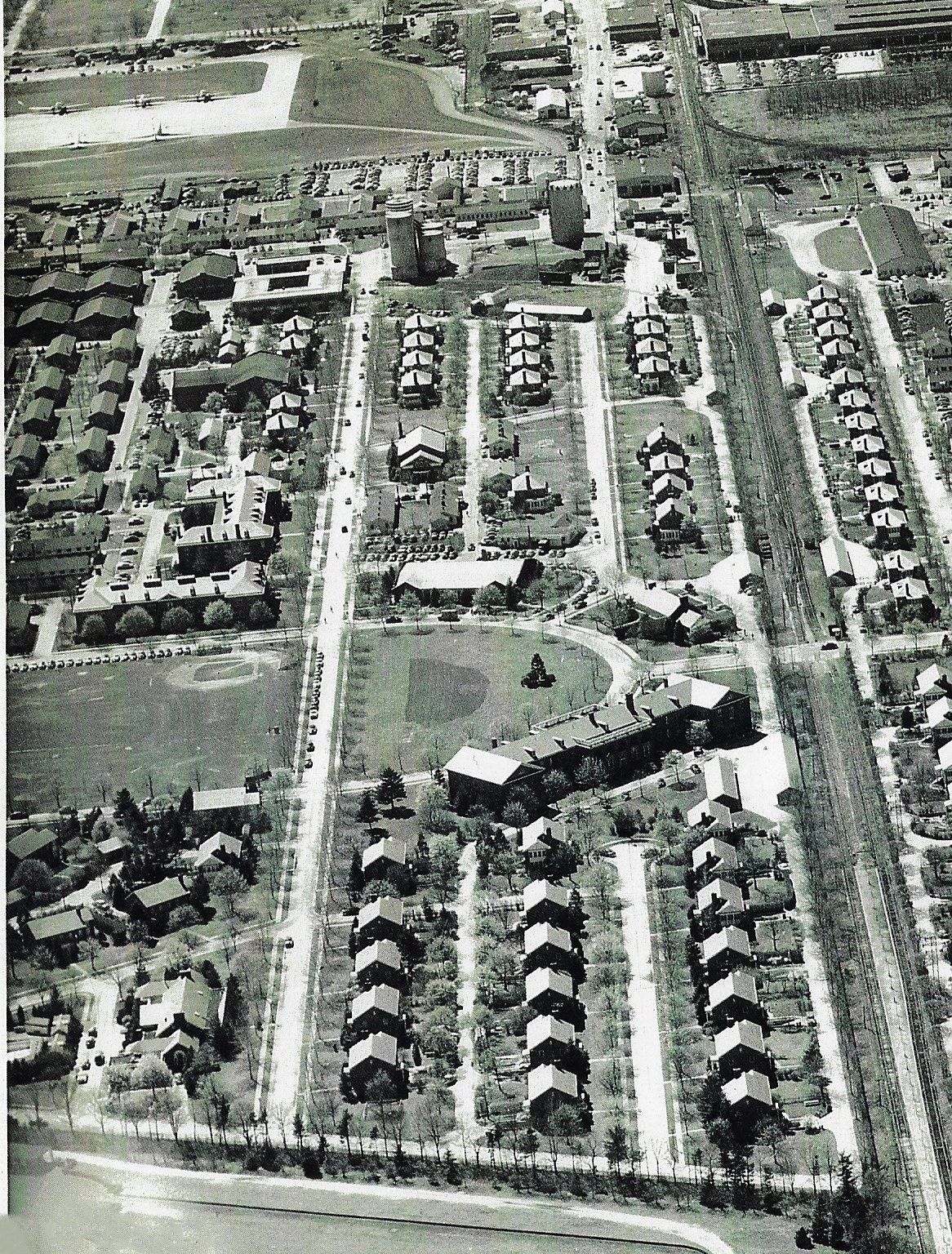
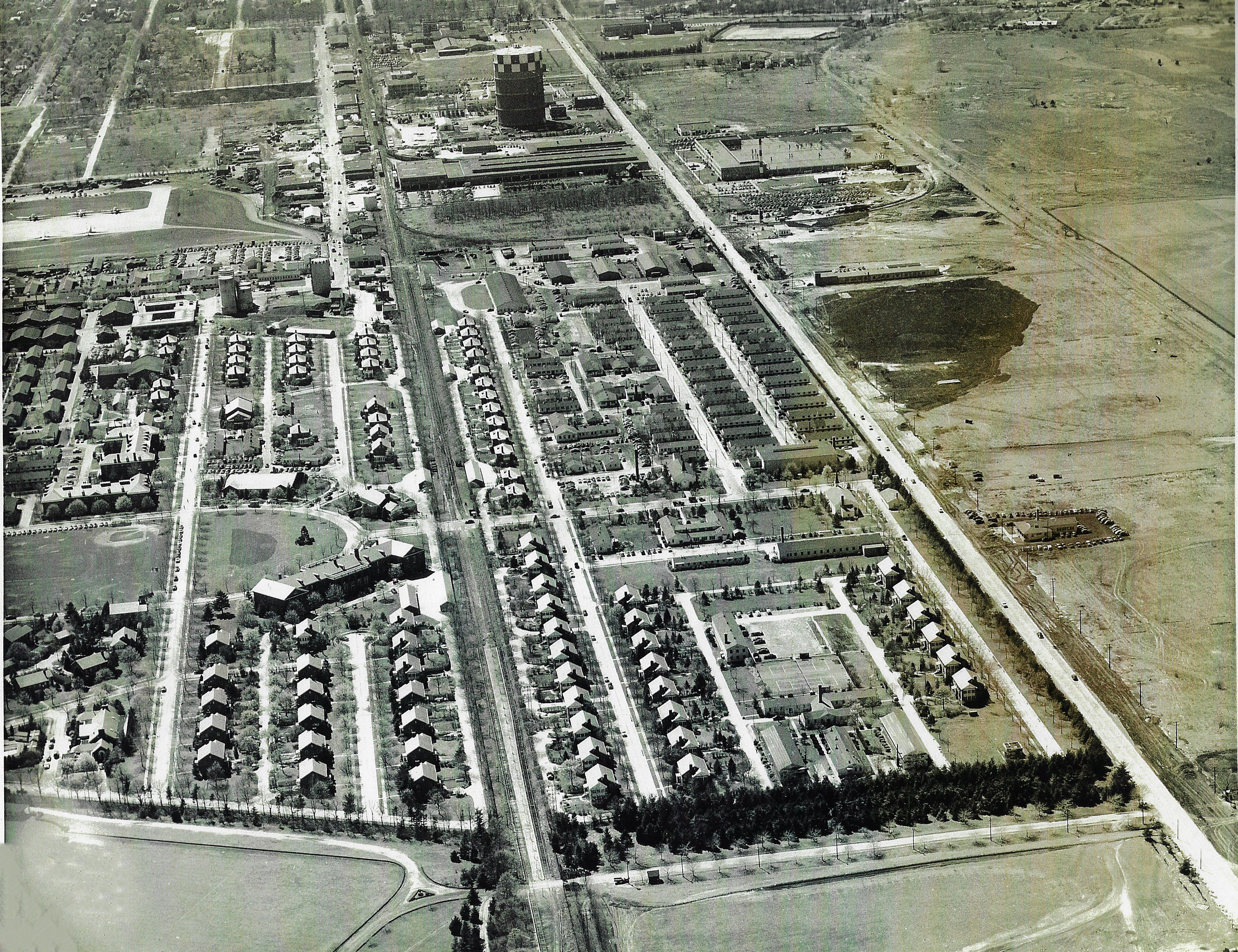
Mystery Foto #8 Solved: A 1951 Aerial View of Mitchel Field & the Motor Parkway & 2017 Circus Trains

My favorite co-author Al Velocci challenged you to identify this weekend's Mystery Foto.
Answers to the Mystery Foto Questions:
- Identify the orientation of the photographer.
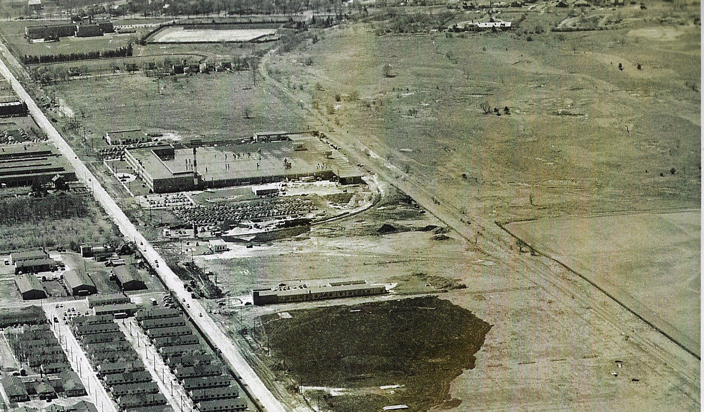
View is looking west with Stewart Avenue the major road on the right.
- Where is the Motor Parkway?
The remnants of the Motor Parkway can be seen north (to the right) of Stewart Avenue. For most of the parkway in this section, the road runs 600-feet parallel to Stewart Avenue as per the property purchase agreement with the heirs of A.T. Stewart.
- Where are the airplanes in the Mystery Foto?
Five planes parked at Mitchel Field can be seen at the upper left corner of the Mystery Foto.
- Identify the major roads
See Brian McCarthy's below captioned aerial. From left to right: Miller Avenue, Commercial Avenue, LIRR, Ellington Avenue, Stewart Avenue and our beloved Long Island Motor Parkway.
- Identify the buildings in the Mystery Foto:
-Building A: Visiting Airmen’s Quarters (Bradley Hall).
-Building B: TBD
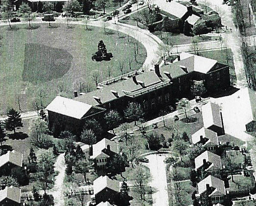
-Building C: Stewart School
-Building D: General Bronze
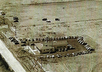
-Building E: A & P Warehouse
- Identify the railroad and golf course in the Mystery Foto.
Central Branch of the LIRR which was still used by Ringling Brothers and Barnum and Bailey to bring the circus to Nassau Coliseum in 2017. See Albert Prete's below amazing photos.
The golf course to the right of the Motor Parkway was the Old Westbury Club (previously the Intercollegiate Golf Club). Later became part of the Roosevelt Field Shopping Mall.
- Kudos question: What is the approximate date of the Mystery Foto? Provide a rationale.
April 24, 1951: Rationale: Besides the caption on the reverse side of the photo:
-The absence of construction of the Roosevelt Field Shopping Mall (1955-1956)
-The absence of the Meadowbrook Parkway
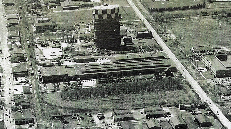
-The presence of the LILCO Gas Holder
Comments (7)
Congrats to Albert Prete, Joseph Oesterle, Sam Berliner III, Lee Chambers, George Philippides, Brian McCarthy and Steve Lucas for correctly identifying many of the Mystery Foto questions.
Kudos to Albert Prete, George Philippides and Steve Lucas for coming close to the 1951 date.
A special shout-out to Albert Prete for capturing the last circus trains on the Central Branch of the LIRR in 2017.
Enjoy,
Howard Kroplick
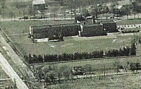
Five airplanes can be seen in the upper left corner.
Building A:Visiting Airmen’s Quarters (Bradley Hall). Now: Part of Nassau County Community College.
Building B: Still TBD.
Building C: The Stewart School
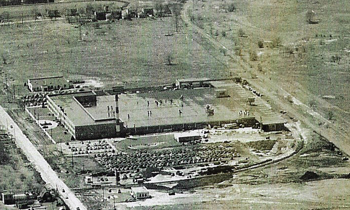
Building D: General Bronze
Building E: A & P Warehouse
Then: 1951
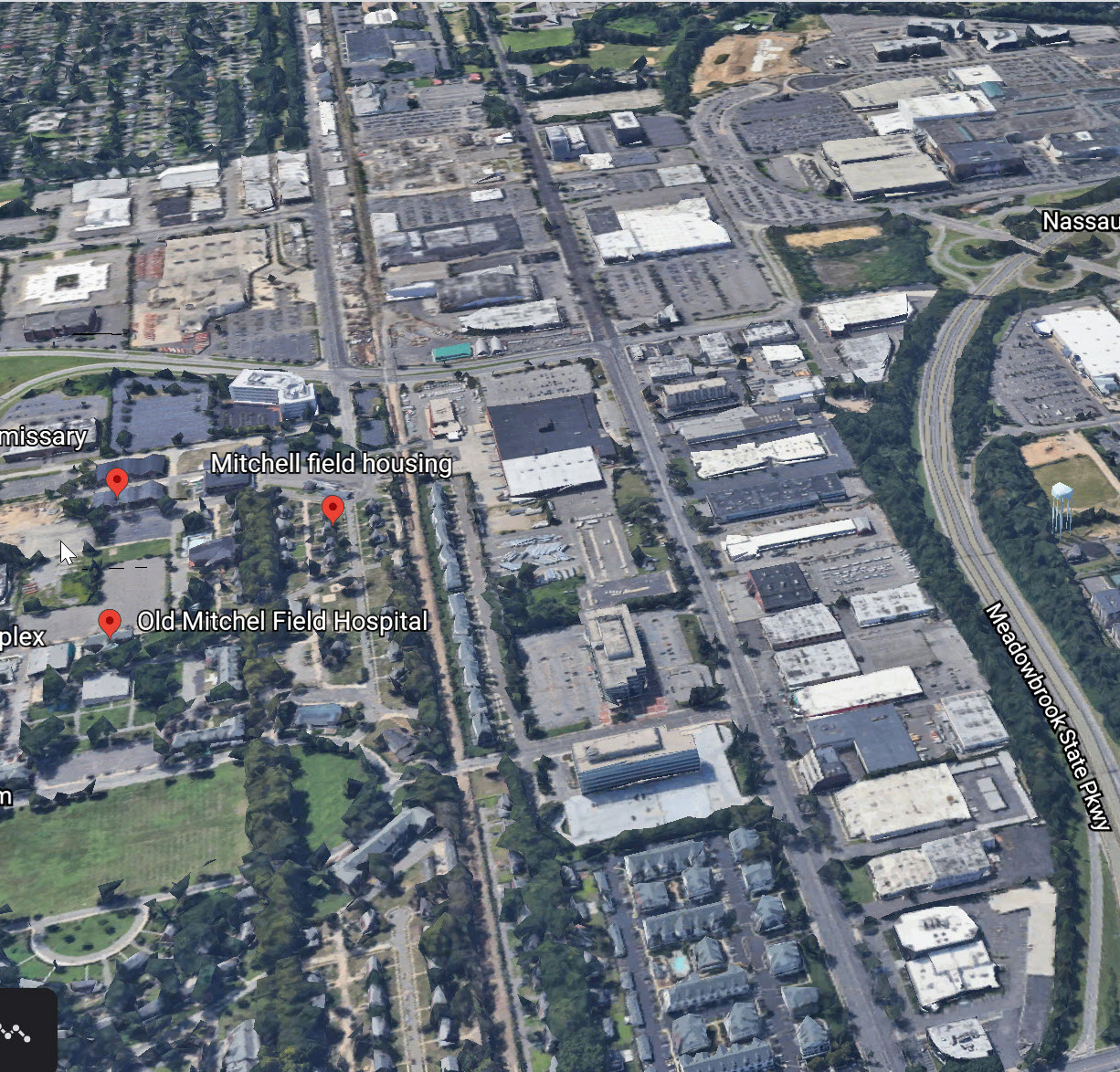
Now: 2020
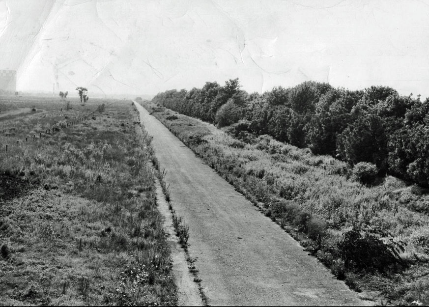
View looking west along the Motor Parkway toward the LILCO Gas Holder (1950)


Comments
The photographer is looking west.
The Motor Parkway is in the upper right-hand corner of the picture. It is visible as a faint line that curves to the right at the very top.
Airplanes can be seen at the upper left, west of the buildings that are today Nassau Community College. They can be seen in the first closeup.
Building A is Bradley Hall of Nassau Community College. I have no idea about Buildings B, C, and D. Building E looks like the Garden City postal distribution center.
The most important road in the Foto is Stewart Avenue from lower right to upper center. Also identifiable are Selfridge Avenue, Ellington Avenue, Wheeler Avenue, Hazelhurst Avenue, and Duncan Avenue (Hazelhurst and Duncan form the horseshoe). Upper left, between the planes and the postal distribution center, is Commercial Avenue.
The railroad is the old LIRR Central Branch (aka the Stewart Branch) a bit to the right of the horseshoe. The golf course, to the north (right) of the Motor Parkway, is the Old Westbury Golf Club. It was sold to developers in 1950.
The Foto had to be taken around 1950, perhaps a bit before, because the golf course is there and there is no apparent construction of Roosevelt Field shopping center, which opened in 1956. Also, the planes appear to be ‘40s vintage.
I went over to the college in 2017 to snap some pictures of the circus train, which parked on the Central Branch whenever the circus was at Nassau Coliseum. The circus went out of business after the 2017 Coliseum shows. I wanted to capture a bit of history.
_________________________________________________________
Howard Kroplick
Albert, these photos are amazing! Thanks so much for sharing!
LIMP is on the right. Top to bottom. Follow the LIMP up to Roosevelt Field, and down to the Meadowbrook Lodge.
Building E is the Gas Tower.
Looking west along Stewart Avenue, with the ubiquitous LILCO gas holder at top, from above Merrick or Whaleneck Avenue. The LIMP is the dark line at right. The planes are on Hazelhurst Aviation Field #2/Mitchel Field. Roads - Stewart and LIMP as noted, Commercial to the left/south of the tracks, Hazelhurst around the oval, Clinton across the very top. A is the post HQ. B - base hospital?. C - the Stewart Elementary School. D - General Bronze? E - U. S. Marine Corps(?) with gas holder. The tracks are the former Central RR of LI/LIRR Central Branch/MTA-LIRR Meadowbrook Secondary; forgot the GC name. Date immediately prior to WWII - monoplanes on field and lack of development along north side of Stewart. Sam, III
Orientation is facing West.
Major roads from left to right, Miller Avenue., Bane Road (Wheeler Ave. west of that and Commercial Ave. even farther west).
The LIRR Central Line built by Alexander Stewart. Ellington Ave. East (and Ellington Ave. West, west of that - Channel 21’s tower would one day stand at the end of it. Today, townhomes are there.).
North Road (now gone and populated by apartments) and Stewart Avenue. LIMP is north of that and can be seen curving towards Clinton St. near the LIMP Lodge (roughly in line with the South Ring Road at Roosevelt Field today).
Major Buildings at Mitchel Field: Building A - Visiting Airmen’s Quarters (Bradley Hall). Also visible is the PX (now NCC Bookstore) and the Non Commissioned Officer’s Club next to it, next to Selfridge Ave. Bldg. 104 and the one west of that which would become NCC’s North Hall are as seen as well. Coal silos in the distance. NCO Gymnasium and Pool too.
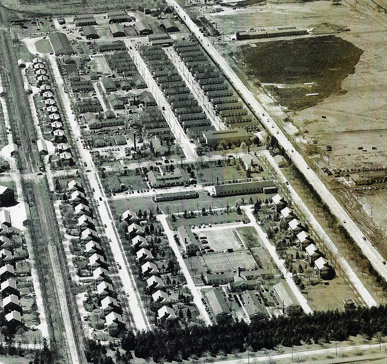
Temporary wooden barracks constructed with the outbreak of War along Stewart Ave. would later be classrooms at NCC, though many were torn down to provide parking in the area to alleviate complaints about students parking in front of Military homes nearby.
In the distance, the LILCO Gas Heats Best tower is obvious. Building E in front of it may have been the A&P distribution warehouse by the railroad siding. Newsday building adjacent to the tower. Building C is the Curtis factory in Garden City.
Planes would be to the left of the photo along the Flight Line, though a few can be seen on the taxiway at the extreme northern tip of the last concrete runway constructed not far from Commercial Ave.
Golf Course was located in the extreme southwest corner of what is generally regarded today at Roosevelt Field and environs, hugging Garden City.
Railroad siding near Building D where it crosses Stewart Ave. is where Quentin Roosevelt Blvd. now is. Gulf service station at that intersection has not yet been built. Across the street from where it would be constructed appears to be a private residence, not connected with the Base.
As for the date, barracks mean it’s after 1941. Lack of Endo Labs in the bottom right corner indicates it’s pre 1963. Baseball diamond on the Quad suggests in could be 1950’s. 780’ low cinder platform on the LIRR means it’s likely before service was terminated on the line in 1953 (other than once a night service to Roosevelt Raceway). Presence of Building B is pre Garden City Bowling Alley. Extreme small size of trees across the Base could be from 1940’s. Lack of Meadowbrook Parkway is pre 1956. Polo Field in the extreme bottom left is pre MSP too.
Looking west down Stewart Avenue Garden City.
Building A is Nassau Community College( now)
Building B is near Garden City Bowl/near old Meadowbrook Polo Club
Building C is Stewart School, which I attended for grades 4-6
BuildingD, no clue.
Structure near Building E( a factory) is the Lilco Gas tank.
Airplanes are in Mitchell Field
The gold club is the Old Westbury Golf Club(formerly Intercollegiate)
The Railroad is the Garden City-Mitchell Field connector off of the LIRR
Year is early 1950s, after Meadobrook Polo Club left, before Roosevelt Field Mall developed
*Orientation of Photographer - viewing west
*LIMP - upper right of image, curving north past Clinton Rd
*Planes - located at runway area south of Commercial Ave, east of Oak St
*Roads - LIMP, Stewart Ave, Ellington Ave, Main Gate ( Selfridge Ave ),Miller Ave, Oak St, Commercial Ave, Clinton Rd.
*Buildings: A - Visiting Officers Quarters, B - Recreation Center ( Military? ), C - Stewart School, D - General Bronze Co., E - A & P warehouse
*RR and Golf Course - LIRR East & West, Meadowbrook Golf Club
*Year & rational - I’ll say 1948. I don’t witness the General Bronze Co. in a 1940 aerial, and the long narrow building east of General Bronze is gone in a 1950 aerial. Upon extreme zoom, this long building has lettering along it; but I can’t form it together.
We are looking west with Stewart Avenue being the main road going from the lower right corner to the top center. The LIMP is curving eastward from Clinton Road near the top right corner. Several airplanes are parked on a taxiway near the upper left corner. Besides Stewart Avenue, the major roads in the photo are: Commercial Avenue; Wheeler Avenue; Miller Avenue; Duncan Avenue; Hazelhurst Avenue; Selfridge Avenue; and Bane Road. The Central Branch of the LIRR runs through the center from top to bottom. The golf course is the Intercollegiate Golf Club (Old Westbury Club) in the upper right corner. Based on an enlargement of some of the cars, I think the date is around 1950. An old diagram shows building “A” as bldg. 368 and that’s the best I could do for buildings before running out of time.
I referred to the Mitchel Field Atlas below for the B?
The long narrow building east of General Bronze must have been built after June 1950 since it’s not in the aerial below, but existing in the 1951 aerial.
I noticed the B building still looking the same in a 1966 aerial ( but surrounded by a whole lot of newer buildings on the N/S of Stewart Ave ) It’s directly across the 2 narrow Mitchel Field buildings S/O Stewart Ave ( black lined in 1951, white lined in 1966 ).
Oops - the USMC was WEST of the gas holder, between that and the east end of the Curtiss plant on the SE corner of Clinton and Stewart. One comment that I let slide is the frustration that the top of the photo doesn’t quite reach the east end of the Curtiss plant (13 Aug 2018 Mystery Foto #32). So many of these fab photos stop just short of some feature of great interest. Curses; foiled again! Hey, look again at Brian’s Myst. Photo #19 Hammond 1950 aerial. Is that a race track immediately west of Raymond Ct. or just a now-gone running track for the Stewart School? Sam, III
Addendum: General Bronze would relocate to Florida in 1966. The A&P Warehouse would move further east on Stewart Ave., east of the Park about the same time.
Lee - where “east of the Park” on Stewart could A&P have moved, please? It’s all residential and light commercial. Sam, III
In Gary Hammond’s June 5th 1950 photo at the bottom is what still left of the LIMP a small curving turn into Clinton Ave. that Howard had brought up in a previous time, last year? about saving this section as historical landmark site.