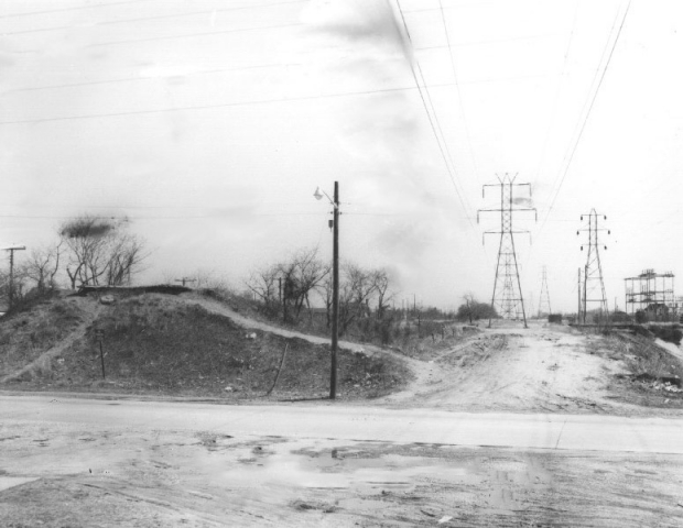
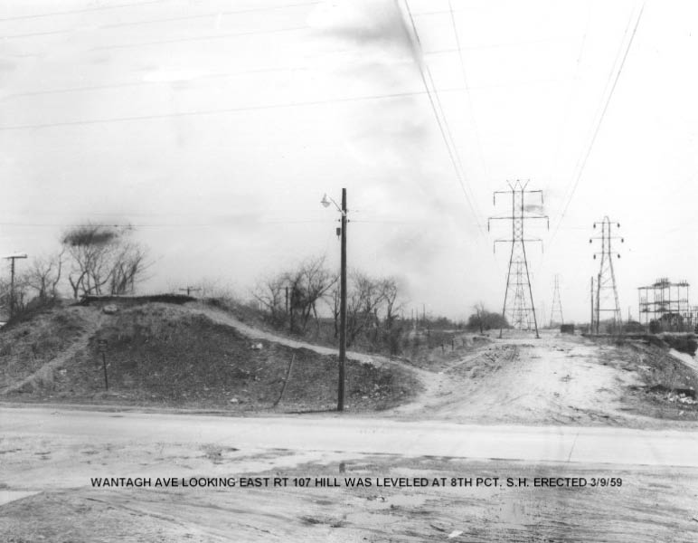
Mystery Foto #80 Solved: The East Embankment of the Wantagh Avenue Motor Parkway Bridge in the 1950s
Al Castelli of West Babylon challenged you to identify this week's Mystery Foto.
Answers to the Mystery Foto questions:
-Identify the Motor Parkway location of this photo.
The east embankment of the Wantagh Avenue Motor Parkway Bridge in Levittown.
-Describe all the features in the photo.
Motor Parkway pavement can be seen on top of the embankment. The former LIRR Central Branch Right-Of-Way can be seen to the right of the embankment. LILCO utility lines and a substation are also on the right.
-What is the approximate year of the photo? Why?
The photo is undated. However, the bridge was likely taken down around 1949 and the embankment was removed in 1959. Accordingly, the best guess is the photo was taken sometime from 1949 to 1959.
-What is currently in this location?
The Nassau County Police Department 8th Precinct built in 1959. The utility lines and substation (now PSEG-Long Island) are still standing.
Congrats to Greg O., Tim Ivers, Joe Osterle, John Hlasny, Brian McCarthy, Art Kleiner, Frank Femenias and Bob Albertson for correctly identifying the location and features of the Mystery Foto. Kudos to Art Kleiner for his below Kleiner Korner documents.
If you wish to submit a future Mystery Foto, please send it to me at [email protected] .
Enjoy,
Howard Kroplick

The photo with its caption
Closeups
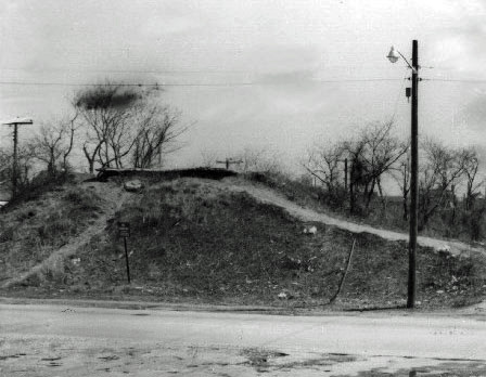
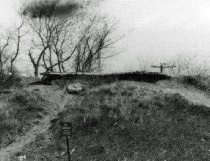
Note the Motor Parkway pavement.
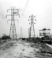
LILCO utility lines and a substation.
Wantagh Avenue Bridge- Circa 1908
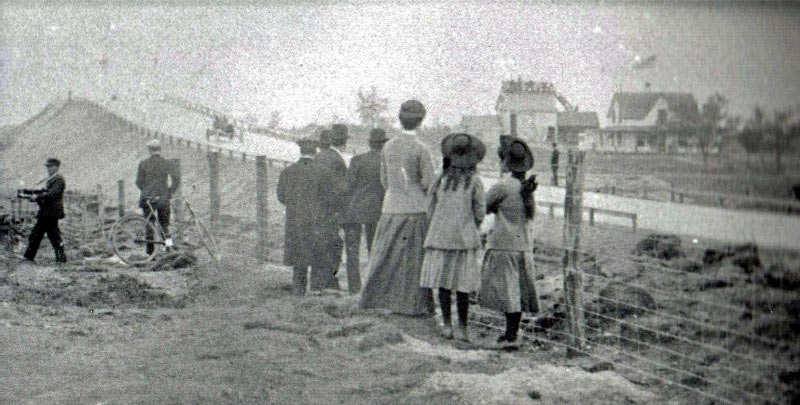
The view of the bridge looking west.
Wantagh Avenue Bridge-Circa 1910
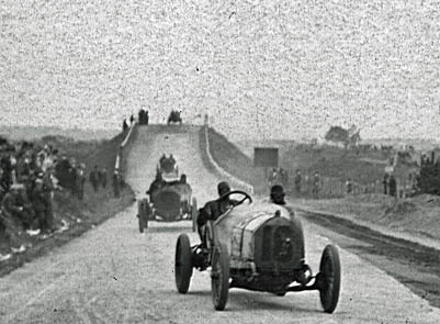
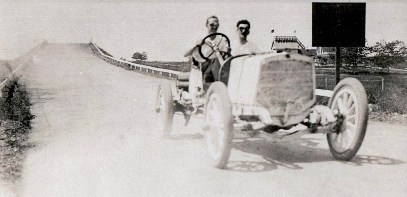
Ralph Mulford testing his Lozier after going over the Wantagh Avenue Bridge.
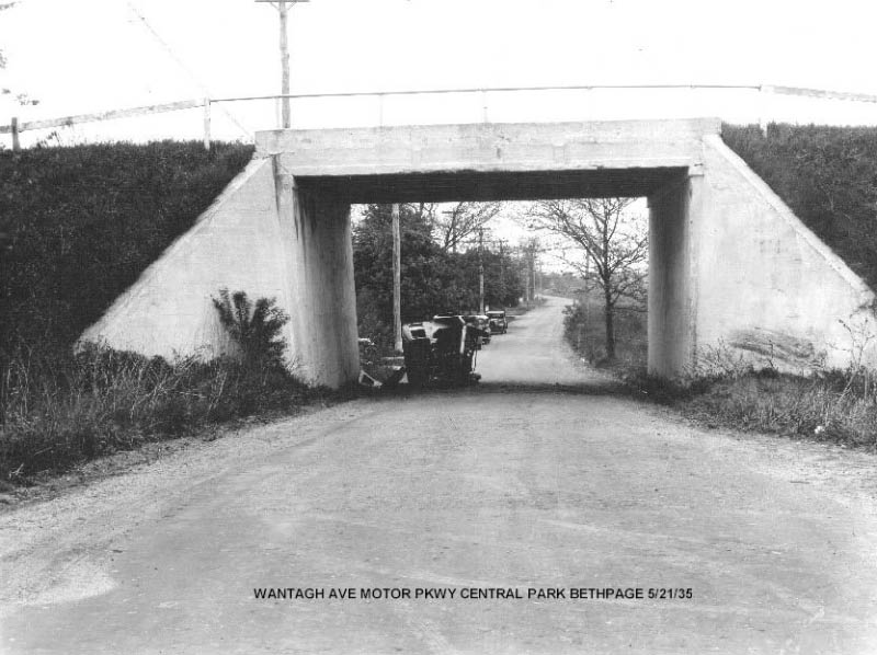
Wantagh Avenue Bridge- May 21, 1935
East Embankment of the Wantagh Avenue Bridge-1950s
Current Views
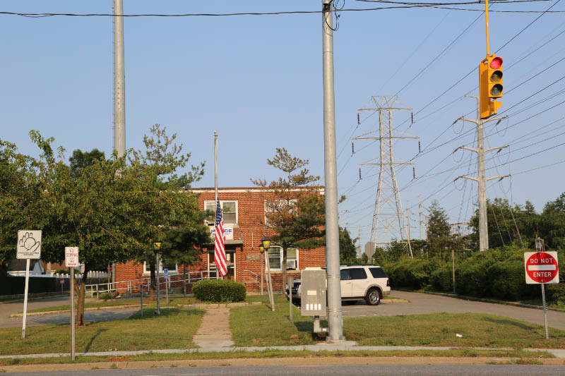
The same view as the Mystery Foto as seen today. The Nassau County PD 8th Precinct building was built right in line with the east embankment for the Wantagh Avenue Bridge. Ron, does this bring back memories? Note the utility lines on the right. The first transmission line has not changed on over 50 years.
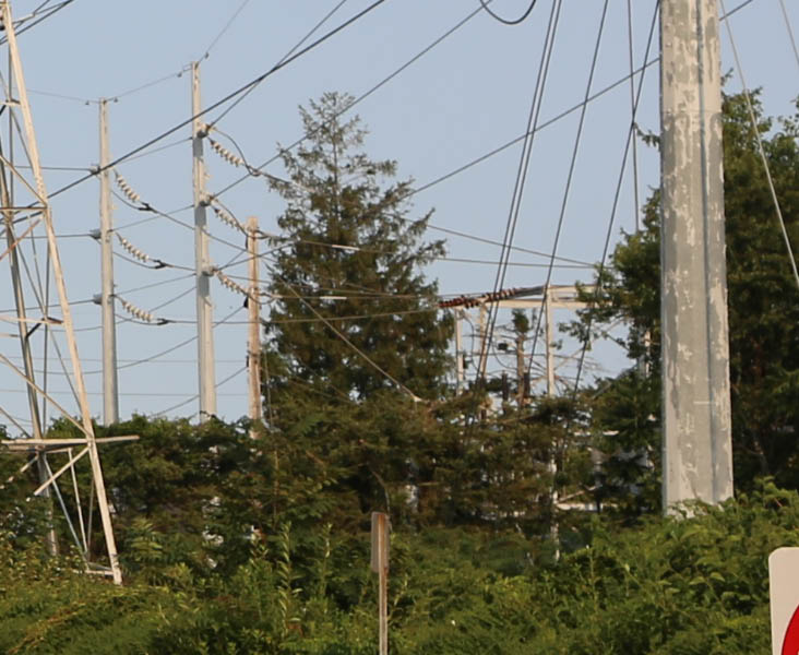
Hidden behind the "Island" trees is the matching rectangular utility substation structure seen in the Mystery Foto.
Kleiner's Korner (Supporting documents submitted by Art Kleiner)
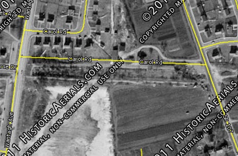
Art Kleiner:1953 aerial from historicaerials.com.
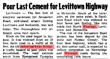
Newsday, November 30, 1949
Art Kleiner: The 1949 article notes the demolition of the Motor Parkway Bridge over Jerusalem Avenue, a little west of Wantagh Avenue. I couldn't find an article about the Wantagh Avenue Bridge coming down but it probably was soon after. Definitely before the 1959 construction of the police precinct.
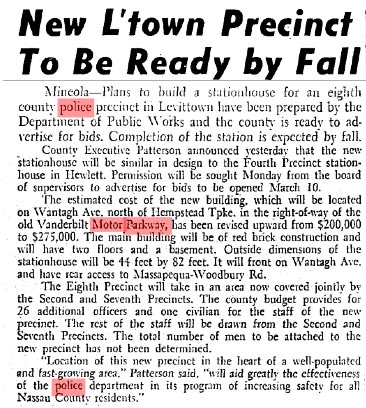
Newsday, February 4, 1959
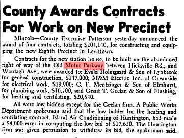
Newsday, April 2, 1959
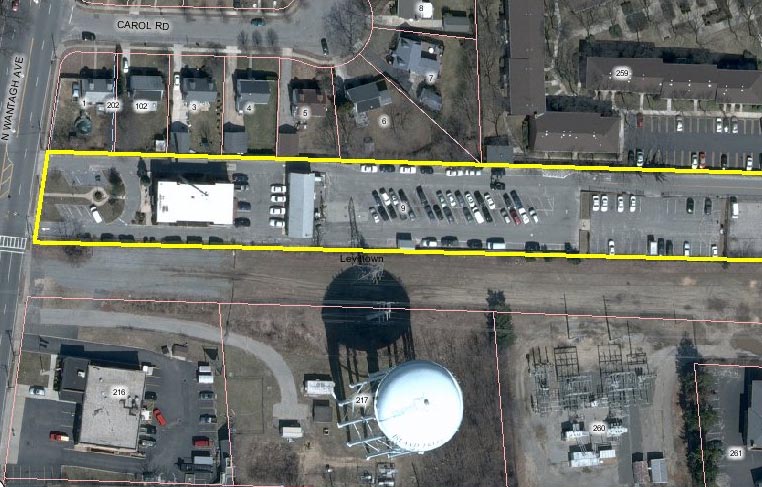
Art Kleiner: Current aerial from Mapquest.


Comments
Pre Levittown, The remains of the Long Island Aviation Club Hangar looking east from Jerusalem Avenue Levittown, in the 1940s when the power lines took over the ROW. also former site of the Press Box during the Motor Parkway days is my guess.
sorry…looking WEST from Jerusalem Avenue
also behind the hill on the left would be the tops of the LIRR central line telegraph poles.
-Identify the Motor Parkway location of this photo.
Another educated guess on this mystery foto, but I’ll go with where the LIMP went over Wantagh Ave in Island Trees(Levittown)/Bethpage.
-Describe all the features in the photo.
The ever-present power lines follow the LIMP on the South side and there are very few trees. Because of that, one can assume that we’re looking East and this would be remnants of one of the few LIMP ‘parkway’ bridges in the Hempstead plains area. I’m thinking those are the remains of the East side embankment of the Wantagh Ave LIMP bridge which was taken down in 1947. There appears to be a structure being built on the right which I can only identify as the million gallon Island Trees water tower.
-What is the approximate year of the photo? Why?
-What is currently in this location?
I’m guessing somewhere between 1954-1959. Aerials from 1953 do not show the water tower, and in 1960, Nassau County built the 8th precinct on the spot where the embankment is in the photo. I couldn’t find any information as to what year the water tower was built which could have exactly dated the photo.
There is also currently a firehouse in front of where the water tower is.
It looks like the right of way for the LIMP. Looking eastward at Wantagh Avenue, Levittown about 1959, the hill on the left shows the remains of the Parkway pavement. The parkway bridge went over Wantagh Avenue at this point. On the right side are the LILCO towers and transmission lines and substation in the background on the extreme right. The power lines and towers were erected on property owned by the Long Island Railroad, Central Branch.
This location was the railroad right of way.
The parkway hill gave way to the 8th Precinct station house of the Nassau County Police.
Wantagh Ave, currently a Nassau County Police Station. Obviously, the date is after the parkway closed, and before the station was built. The LIRR ROW ran just south of the parkway. The Massapequa Lodge is just down the road a bit.
-joe
Looking East across Wantagh Avenue toward Hicksville Road. The power sub station still exists but is upstaged by the Island Trees Water tower and Levittown FD station 3. The old overpass was eventually leveled when the Nassau County Police added the 8th Precinct in about 1960.
My comment said the overpass was leveled
correct wording would be ” the eastern side of the overpass grade was leveled about 1960”
I’m not of age to have an actual memory of this scene, but I know the area. This is Levittown, looking east across Wantagh Ave. The remains of the LIMP/East Abutment is seen at the left.The PSEG Row is to the right, Levittown substation near distance. The steel towerline to the right is now steel poles. Pre-1960, 8th precint (community policing center) was built at LIMP location in photo (1960).
This one’s too easy; it’s quite obviously a flying saucer hovering over broken end of paving on the east embankment at Newbridge Road or Jerusalem Avenue or thereabouts ca. 1980! I have/had a close-up of that exact spot somewhere on my site. No, I did NOT leave my wheel there. That might even now be the location of Ron Ridolph’s old 8th Precinct house at North Wantagh Avenue. Sam, III
-Identify the Motor Parkway location of this photo.
Site of the Wantagh Ave. Bridge, looking east towards Hicksville Road. Across from today’s Universe Drive.
-Describe all the features in the photo.
The eastern abutment of the Wantagh Ave. Bridge; Motor Parkway roadway; Massapequa Motor Parkway Lodge in the distance; LILCO Power Grid on the right in the background.
-What is the approximate year of the photo? Why?
Late 1950s, no later than April 1959 when the NCPD 8th Precinct was erected on the site.
-What is currently in this location?
NCPD 8th Precinct, also nearby to the south is the Levittown FD #3 station house (built in 1960) and the Island Trees Water Tower.
Good stumper photo. Many possibilities here. Guessing, I’d say were in the Massapequa corridor looking E at the future site of the Nassau County Eighth Police Precinct. If so, that is a hilly abutment remnant of the LIMP N Wantagh Ave Pkwy Bridge. LIPA towers to the right/South, LIMP ROW to the left/North. You got me again, too many possibilities.
On Wantagh Ave. Levittown. NY Before the Nassau County Police Department and the Levittown Fire Dept. was built and the Island Trees water tower is being built.
This looks to be the old Motor Pkwy overpass that was at the back of the National Cemetery near Colonial Spings Road between Little E. Neck and Pinelawn Road. I am going to say the time was around 1945-50.
I was a confused with this one, because of the power lines and that hill, to many possible answers, so I didn’t bother with it, it wouldn’t have been a definite answer, so I’ll wait and see what it is
stumped again !!! good one, mike