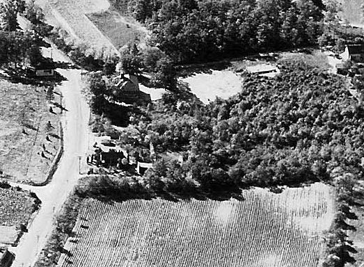
Mystery Foto #60 Solved :Motor Parkway Near Round Swamp Road in Bethpage, Old Bethpage & Farmingdale

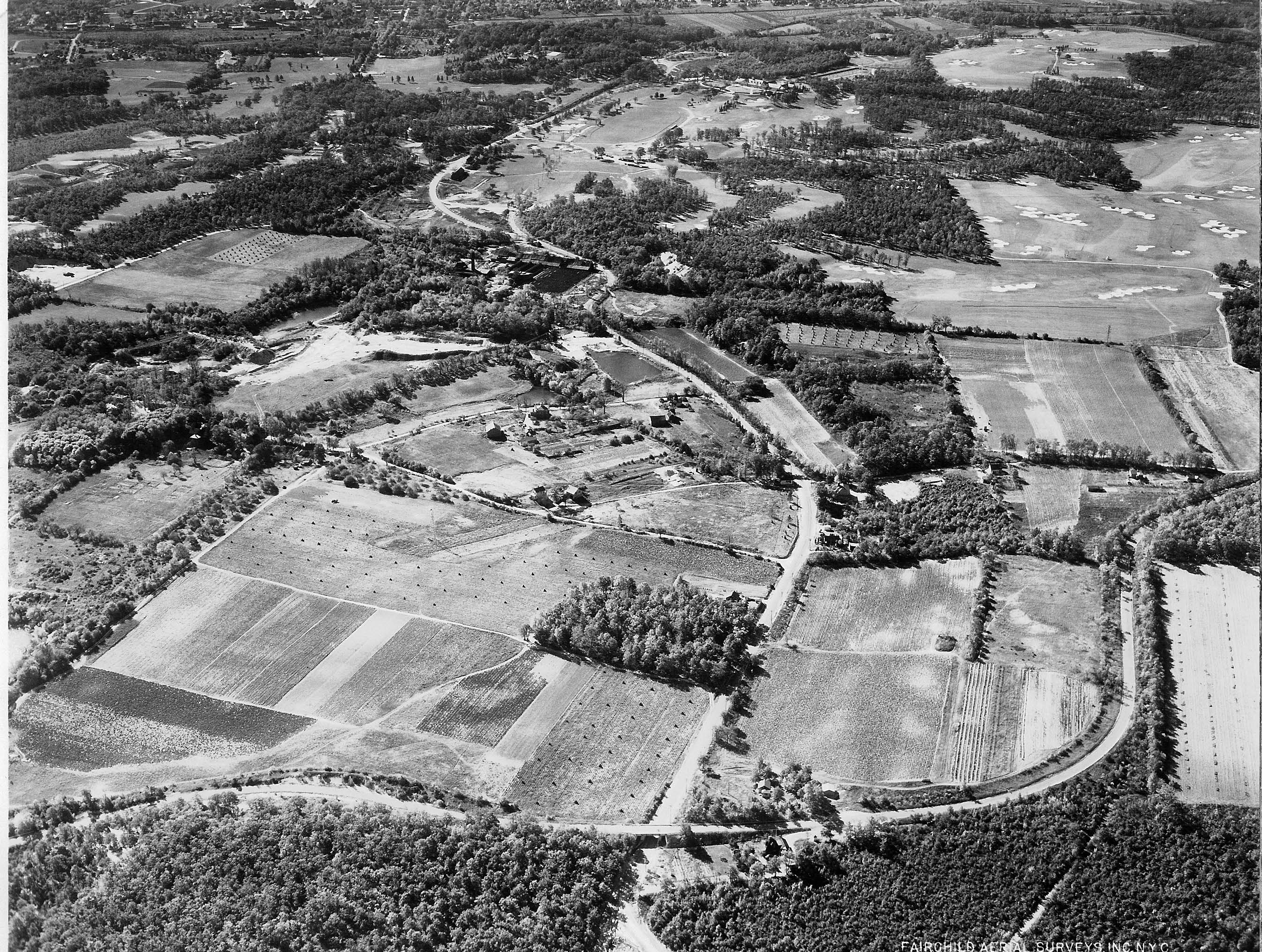
This week's Mystery Foto was a beautiful 1935 Fairchild aerial of the Long Island Motor Parkway near Round Swamp Road.
Mystery Foto questions:
-Identify the Motor Parkway and its location
This aerial is looking south with Round Swamp Road seen in the middle dividing Bethpage (right) and Old Bethpage (left). The Long Island Motor Parkway is located on the bootom of the aerial.
-What other significant structures are seen in the aerial?
The Bethpage Lodge, the entrance to the lodge and the Round Swamp Road Motor Parkway Bridge are seen on the middle bottom of the aerial The golf courses of the historic Bethpage State Park .can be seen on the top and right of the aerial
-What is the date of the aerial?
October 16, 1935
Congratulations to Joe Osterle, Greg O, Tim Ivers, Michael M., Art Kleiner, Frank Femenias, Steve Lucas and Brian McCarthy for solving the Mystery Foto. Kudos to Greg O., Tim Ivers, Michael M. and Art Kleiner, Steve Lucas and Frank Femenias for identifying the other structures and dating the 1935 aerial.
Enjoy,
Howard Kroplick
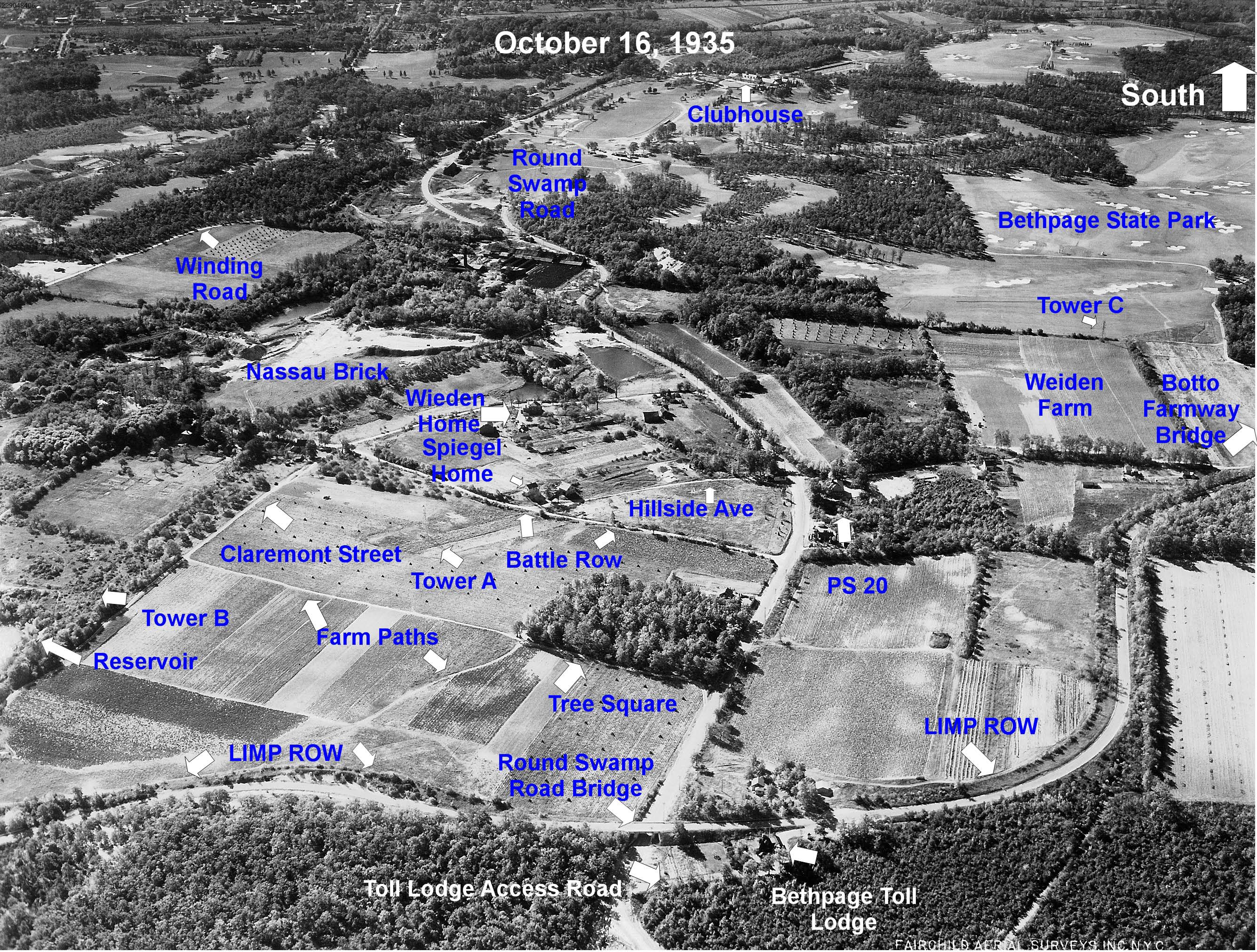
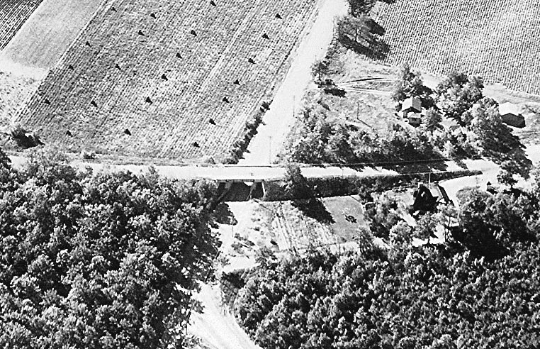
The Bethpage Lodge, lodge entrance and Round Swamp Road Motor Parkway Bridge. The Bethpage Lodge was one of the three original toll lodges built in 1908.
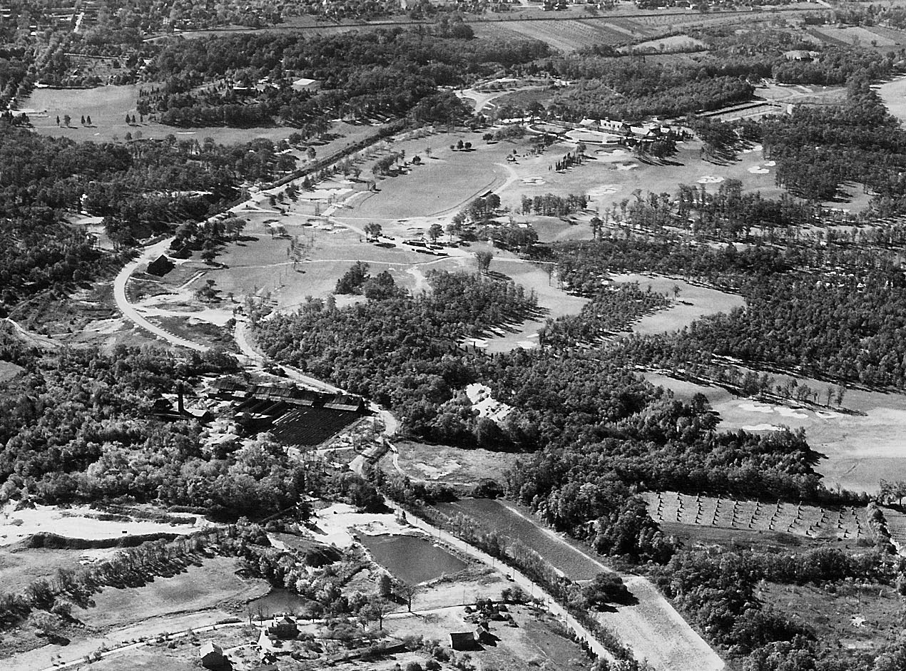
Bethpage State Park in Farmingdale
I believe PS 20 is the building on at the top of this closeup, located on Schoolhouse Lane


Comments
Round Swamp Rd, looking South. Bethpage Toll Lodge. Bethpage golf course can also be seen. I think fairchild did many of their aerial photos in the early 1940’s.
-joe
Love the Fairchild aerials, and this is one of the best ones! (along with the Beacon Towers, Deepdale and Harbor Hill aerials)
-Identify the Motor Parkway and its location
The view is looking South at Round Swamp Road with the LIMP going over at the Battle Row campgrounds.
-What other significant structures are seen in the aerial?
The RSR bridge, the Bethpage Lodge and a glimpse of the Bethpage golf course.
-What is the date of the aerial?
1935
Guess what Howard? I have to leave this one for the experts. I see structures at the top, that might be something, there are others too. Any one of those roads could be Motor Parkway. Maybe if I had some sort of a hint, it would help. I see things, but can’t identify them, even when I zoomed in on it
Looks very familiar. The Old Bethpage area. Looking south. Running left to right across the bottom is the Motor Parkway, with the bridge over Round Swamp Road (running top to bottom). The Bethpage toll lodge is visible on the right (west) side of Round Swamp and on the north side of the parkway. Further south on Round Swamp, on the left (east) side is the Nassau Brick Company. At the top center, west side of Round Swamp, are visible the fairly new (1935 photo) Black Golf Course holes.
Old Bethpage, looking south towards Bethpage State Park. The parkway crosses Round Swamp Road in the foreground. Photo taken October 16, 1935.
Guessing from the Google Maps LIMP I would say we’re looking south, parkway is on bottom of frame going left to right before turning south. Bridge is over Lakeview Road.
The other significant structures are the Great Neck Lodge (I cannot ID it on the pic)
I couldn’t set the time closer then between ‘10 (when the parkway ended at this local) and ‘31 (when the Northern State PW came thru).
This 1935 photo shows The Motor Parkway at the bottom of the photo going left-right and is in Bethpage. It is going over Round Swamp Road. Since this photo is looking south the Bethpage Lodge is directly north of the Parkway (beneath it on the photo) and west of Round Swamp Road (to the right). The clubhouse of the Bethpage Golf Course, which was dedicated around the same year, is at the very top of the photo in the middle, directly to the right of Round Swamp Road, above a clearing. The orientation of the picture, i.e., looking south, confused me as I naturally think all pictures face north (don’t ask me why). After realizing this, the fact Round Swamp Road is curving to the left and the golf course was not where I expected it to be made much more sense.
Old Beth facing south, 1935? LIMP winding along the bottom edge and passing over Round Swamp Rd via the Parkway bridge. The Bethpage Lodge (1910-1960’s) and access road just west of the bridge. One of the original 3 Motor Pkwy tollhouses built by John Russell Pope, stood vacant and dilapidated for years before demolition. Bethpage Golf top right (those same sand traps are there today), Battle Row, I think I see LIRR along the top edge of the photo and looks like an aircraft hangar on the top left, possibly an airport.
I think the photo shows the Bethpage area looking north with the LIMP crossing left to right (west to east) in the foreground. Looks like Round Swamp Road going from south to north with the LIMP bridge over it at the bottom center. Just to the right of the bridge would be the Bethpage Lodge and its entrance ramp. I would date the photo around 1935.
My favorite type. of mystery photo, old aerial views. Photo is facing south, with the LIMP running from the bottom left, then west across Round Swamp Rd (Overpass and Bethpage Toll Lodge just N/O the LIMP) LIMP continues south a bit, then running in a S/W direction eventually thru BSP. Mid 1930’ s. There’s probably other landmarks that I don’t know to point out.
Mystery photo 60 meadowbroook CC to the right. Motor parkway in old westbury. 1927 photo.
In Battle Row campgrounds just east of the parkway bridge, wooden posts are used to section off that buffer area along the southern edge of the parkway. The 100+ year old posts are also still standing there today and recently rewoken by Howard, Al, Sam III, and Pat.
http://www.vanderbiltcupraces.com/blog/article/mystery_friday_foto_57_where_isn_the_world_is_sam_berliner_iii_and_al_veloc
As I said, I see structures and roads, maybe even bridges, that could be part of the Motor Parkway. There’s something about the top of the picture that I’ve seen on the left side, it looks familiar to me. Maybe I’ll find out in a few minutes. I’m just lost on this one
I knew there was something familiar about it, just couldn’t pin point it. Now I don’t feel like I was on the wrong track
From Robert G:
What’s PS 20 in the photo? Is that the Little Red Schoolhouse at Round Swamp Rd. and Schoolhouse Lane?
__________________________________________
Robert, see the above close-up that I added to the post.