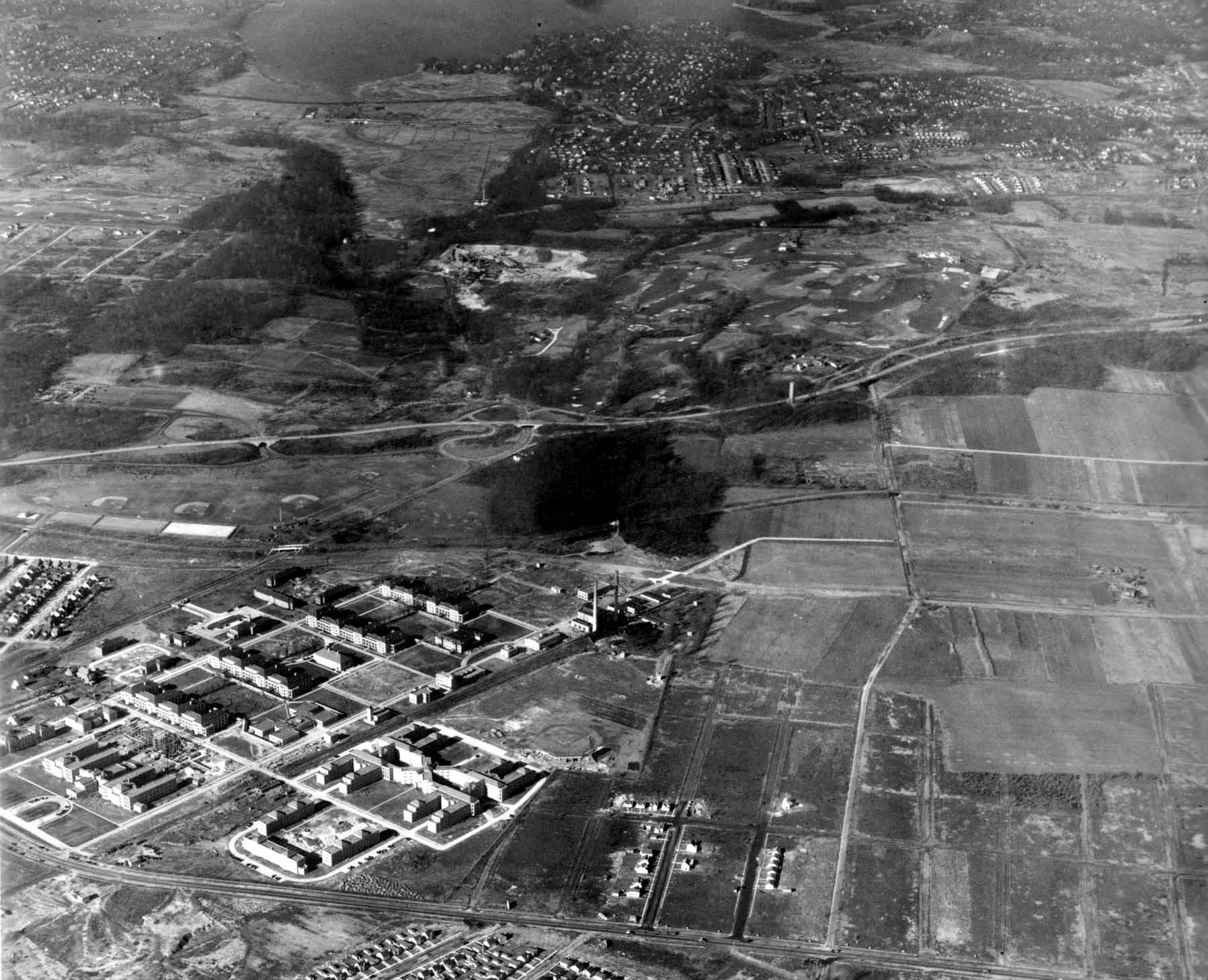
Mystery Foto #5 Solved: Creedmore Hospital and Commonwealth Boulevard Motor Parkway Bridge in 1941
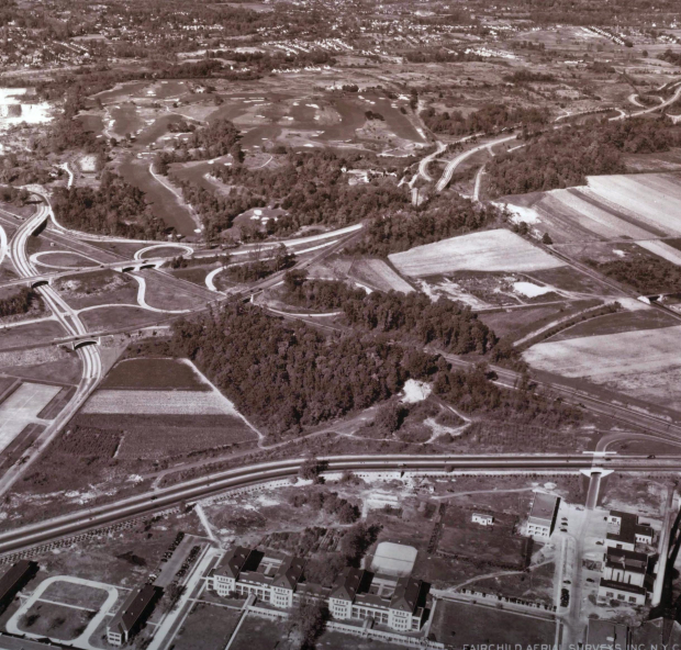
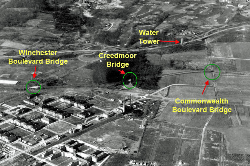
This aerial was taken in October 1941, over 3 years after the Motor Parkway was closed. Looking north, Creedmoor Hospital can be seen in the lower half of the photo with its prominent smokestake on the right corner. Union Turnpike is the main road north of the hospital complex. The Commonwealth Boulevard Motor Parkway Bridge was still standing in the middle far right.
Congratulations to Christopher, Greg, Brian, Eric, Tim, Bill and Frank who correctly identified the location. Eric even sent in a Google Earth snapshop matching the 1941 photo.
Enjoy,
Howard Kroplick
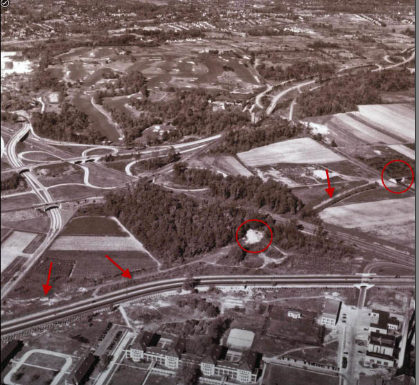
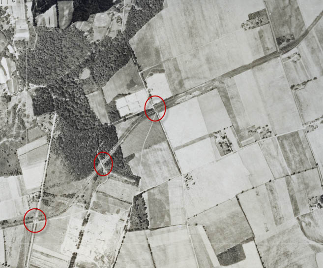
The Motor Parkway right-of-way is indicated with arrows. The white area in the middle was the remains of the Creedmoor Pedestrian Bridge over the Moro Parkway.

A closer look at the Commonwealth Boulevard Motor Parkway Bridge. Note the section west of the bridge had already been taken down to keep automobiles off the closed road.
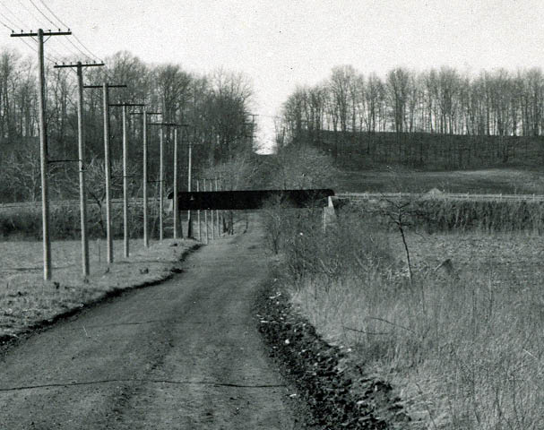
A ground-level view of the bridge looking north.
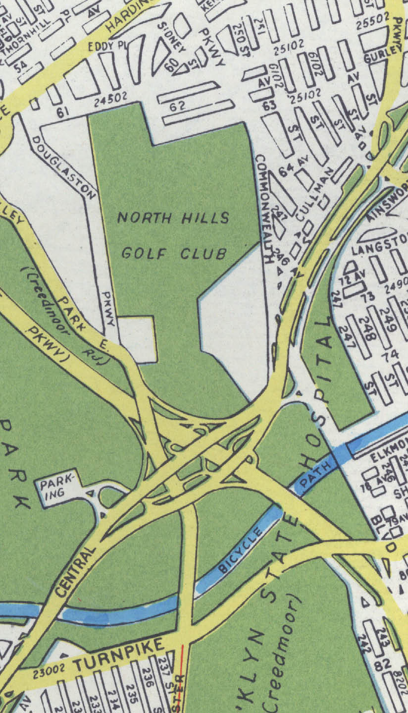
The golf course in the background was North Hills Golf Club, now the Douglaston Park Golf Club. It is located on one of the highest points in Queens.
Another aerial view of the area in 1924.
A spectacular aerial of the location taken on November 23, 1937.
The Motor Parkway was still operating when this aerial was taken.
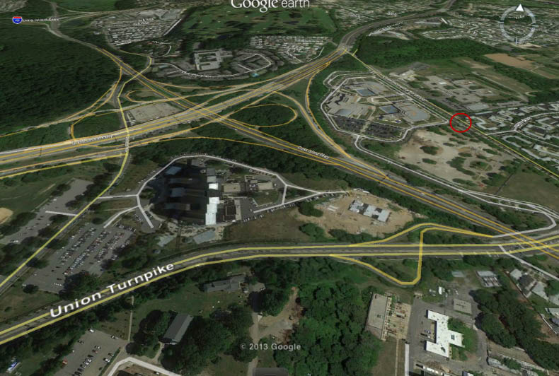
The Google Earth snapshot of the current view sent in by Eric Baudo. I have circled the approximate location of the Commonwealth Boulevard Motor Parkway Bridge.


Comments
Creedmore
This photo is near present Day Creedmoore Hospital in Queens. The smoke stacks near the the bottom are recognizable.
Northward, looking at where Creedmoor is going to be just on the North side of Union Tpke along the bottom. There’s the Cross Island/Grand Central interchange middle left. The Commonwelth LIMP bridge is still up…
This view. Is looking northerly. Creedmore Hospital is to the. south, with Union. Tpke just. north. of. the. hospital, running east. and west. Winchester. Blvd. is present. in. the. left. of. the. photo. LIMP. ROW is. just. north of. Union. Tpke, heading. east ( The. light. colored. area. just. west. of. the. Cross. Island. Pkwy. is. the. pedestrian. bridge, I. think. ) The LIMP. bridge. over. Commonwealth. Blvd. Is. evident. in. the. middle. right. of. the. photo. Douglaston. Golf course. is. north. of. Grand. Central. Pkwy.
This area is where the Cross Island and Grand Central Parkways intersect at Creedmoor Hospital. Today, the main hospital tower is located in the wooded area at the center. Union Turnpike is running across the bottom of the photo. The Motor Parkway overpass at Commonwealth Blvd. can be seen at far right center.
Deepdale Golf Course in upper view. LIMP and LIMP overpass from left to right
in center. Near Nassau/Queens border.
Where Cross Island Parkway intersects Grand Central. Creedmoor at bottom, then Union Tpk., then remains of LIMP south of tree area.
Howard: This week’s 1950 aerial of the LIMP facing SE has a great view of the Old Westbury Golf Club which I am interested in researching. Who has the original of that so I could get a good copy?
Also: the map showing the planned subdivision has the wrong crossing circled.
Look forward to your website every week. Thanks.
Glen Oaks area and Creedmoor hosp is missing! Picture is facing N/NW. Limp is not maintained and is just north of the expanded Union Tpke at the bottom. Alley Pond parking lot is at bottom left parallel to Winchester Blvd / Douglaston Pkwy running North South. Also missing are the limp bridges at Winchester and Creedmoor hwy br. Commonwealth is still there and so is the water tower by the GCP. Cross Isl pkwy appears in the process of being built intersecting with the limp at grade level. Unfortunately, Borough President James Burke wasted no time removing the limp structures soon after closing. Howard, is that the Creedmoor gun range at the bottom?
Ha guys!!! what observations you have,I just enjoy reading what you say,then observe for myself,the heck with trying to figure it out,it’s more interesting this way for me,I just take it all in,instead of racking my brains out,you guys are the pros at this game,I’m just a bystander,if you know what i mean
Does anyone know why the original configuration of the Grand Central Parkway was split into two roadways with a large space in between starting at Union Turnpike and ending at Little Neck Parkway? Was it because of elevation issuses because the parkway was built on a moraine or for entrance/exit roadway concerns?
attached to previous comment:
This picture shows the section in question:
http://iarchives.nysed.gov/PubImageWeb/viewImageData.jsp?id=138750
I watched the film about Marmon#32 “Wasp”,it was very interesting how it’s so different than the others and the
history behind it. I never realized it until know
I enjoyed looking at the 1937 aerial of this area. I grew up across the street from Douglaston Golf Course. The aerial depicts the exact spot where my former home is located. I have one correction. The highest point in Queens is not on the Douglaston Golf Course. It is located on North Shore Towers’ property. Thanks for your Sunday emails. I look forward to reading them every week. Regards, Neal Baker.
From Fred H.
Hi Howard,
As a former resident of North Shore Towers, Queens, i can state with certainty that the high point of Queens is on the GCP Service road between Little Neck Pky and the city line.
Here is an article from a Google search of highest NYC points:
Queens
High Point: Sidewalk near North Shore Towers - 260+’
Fred, thanks for the information. I revised the copy above.
Howard
exits/entrances to Alley Pond Park’s upper parking area and it was a parkway. Northern state/southern state have similar construction features