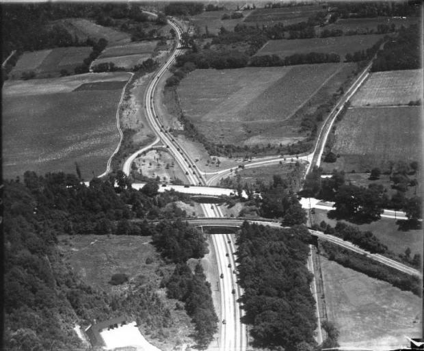
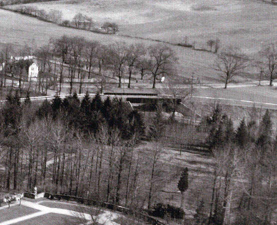
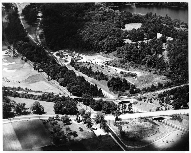
Mystery Foto #49 Solved: A View of Lake Success in 1934
To celebrate 2014, the first Mystery Foto was another vintage Long Island aerial.
Answers to the Mystery Foto questions:
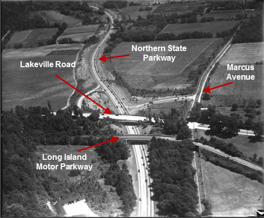
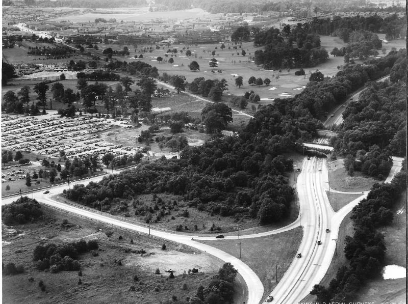
-Identify the four major roads in the aerial which is looking east
North/South:The Long Island Motor Parkway and Lakeville Road
East/West: Northern State Parkway and Marcus Avenue.
-Identify any structures in the aerial
Lower left: Garages for the New York State Parkway Police barracks, formerly part of William K. Vanderbilt Jr's guest house
Right off Marcus Avenue: Barn on the Schumacher farm which later became the parking lot for the Sperry plant.
-What is the approximate year of the photo?
The photo was taken on August 15, 1934, after the Northern State Parkway opened in 1933.
Congrats to Brian, Tim Ivers, Greg O., Mitch Kahn, Steve Lucas, Joe Oesterle, Art Kleiner, Eddie Murray, Roy Warner, Eric Shaffer, Richard Skibins, Dr. Jack Binder and Michael LaBarbera for correctly identifying the Lake Success Mystery Foto. Special kudos to Brian, Tim, Mitch, Greg, Joe O., Art Kleiner, Eddie Murray, Dr. Jack Binder and Roy Warner for estimating the approximate year.
Enjoy,
Howard Kroplick
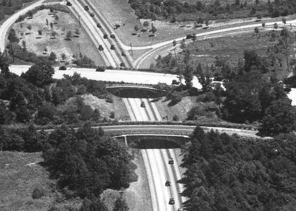
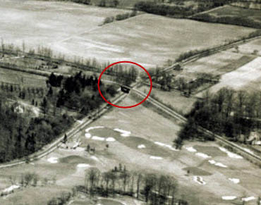
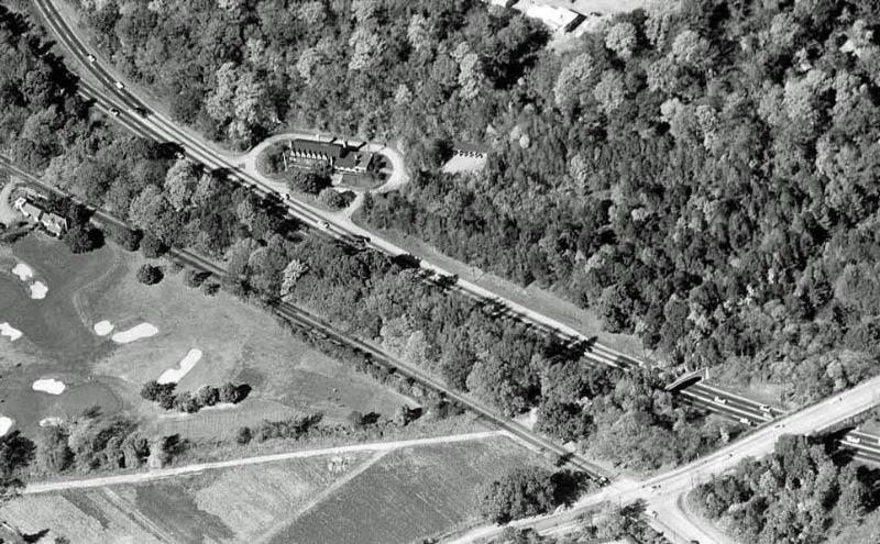
Close-ups of the Lakeville Road Bridge and the Motor Parkway bridge over the Northern State Parkway.
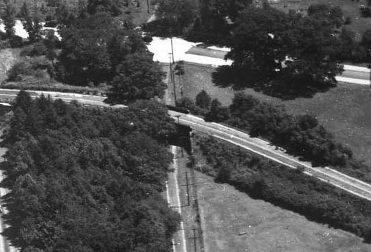
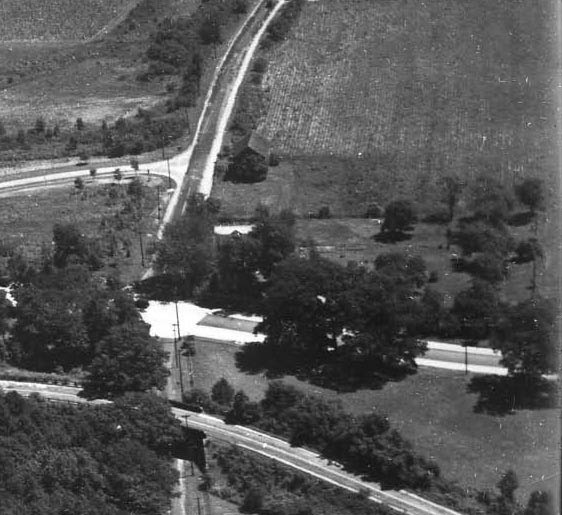
The Marcus Avenue Motor Parkway Bridge.
Two 1927 views of the Marcus Avenue Motor Parkway Bridge.
A close-up of the barn on the Schumacher Farm.
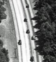
Some of the cars on the Northern State Parkway as compared to not a single car on the Motor Parkway.
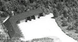
Close-up of the New York State Parkway Police barracks.
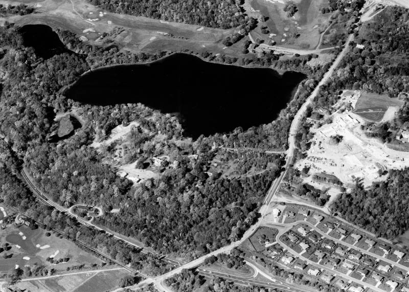
Looking west, an aerial view of Lake Success taken two days after our Mystery Foto on August 17, 1934.
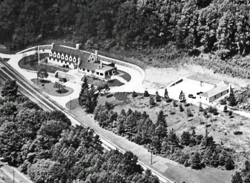
A close-up of the New York State Police barracks and the garage.
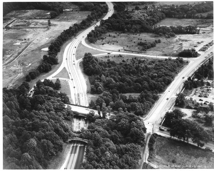
A 1950s aerial looking west. Note the trees and brush growing on the Motor Parkway bridge.
An aerial looking west taken on June 10, 1952. Note the Sperry parking lot.
Another aerial of Lake Success taken in 1955.
A close-up of the New York State Police barracks and the garage. The Motor Parkway bridge was still standing.
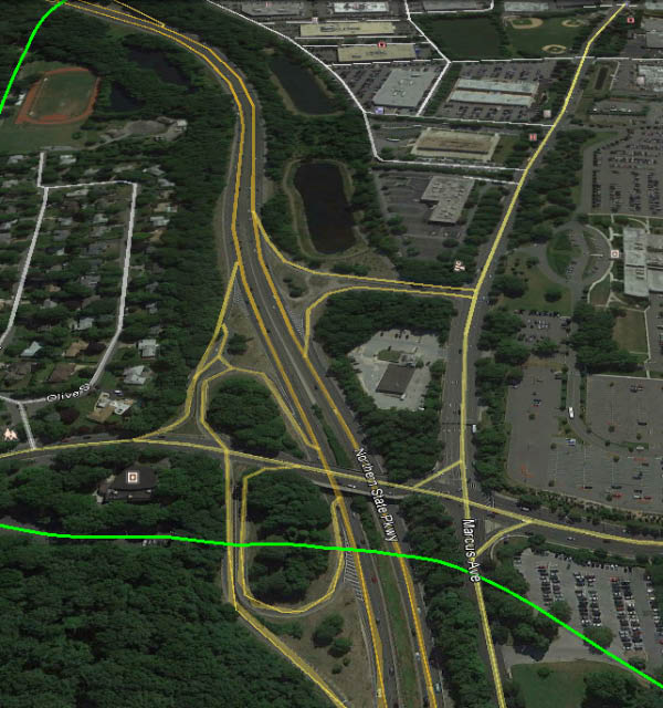
A current Google Earth view of Lake Success.


Comments
1. LIMP, Lakeville Road, Marcus Avenue, NSP.
2. Vanderbilt’s guest lodge.
3. 1937-1940?
Looks like the current intersection of Lakeville Rd and Northern Parkway. The four roads are:
Top: Lakeville Rd
Bottom: LIMP
Left: Northern Parkway (before it was duplexed, with exits to Lakeville Rd)
Right: Marcus Avenue
Bottom left is stables/garage for Deepdale estate?
In the future Great Neck South and Phipps Estate (now GN School Administration Center) would be just left of the photo while LIJ Hospital and Sperry would be just to the right. No Police 6th precinct yet (in either location) and no cars on the LIMP (perhaps just recently abandoned) so I’ll guess 1939?
I grew up near here - boy does it look different now…
Thanks
Brian
L to r across bottom. LIMP bridge across Northern State Parkway in Lake Success
L to r just above LIMP bridge is Lakeville Road
Road running top to bottom on left side is Northern State
Road running top to bottom on right side is Marcus Ave.
Approximate year taken 1935
View facing east: Northern State Parkway, Long Island Motor Parkway, Lakeville Road and Marcus Avenue. Bottom left is the former Vanderbilt guest lodge (State Parkway Police Barracks). I’d date the photo 1937 (which is prior to the closure of the LIMP and relocation of the Lakeville Road exit on the eastbound NSP).
From Greg O.
I’ve always loved this aerial…
-Identify the four major roads in the aerial
The aerial is looking East; Horizontal roads in the photo are the LIMP (bottom) and Lakeville Road (top), Marcus Ave (right), and the new Northern State Pkwy (left) are vertical.
-Identify any structures in the aerial
The main structure is part of Willie K’s old guest house/hunting lodge, which eventually became the NYS Police barracks on the North side of the N. State (on what was originally his Deepdale estate) Too bad we couldn’t see a little more to the left where the Great Neck Lodge is located…There’s also the Marcus Ave LIMP bridge on the right.
-What is the approximate year of the photo?
August 15, 1934
The 4 major roads are: Northern State Parkway, Marcus Avenue, Lakeville Road, and the Long Island Motor Parkway. You are looking east and I believe the the photo was taken around August 15, 1934. Along the lower edge you can see the parking area and garage for the NYS Parkway Police Barracks, which at one time had been part of Willie K.‘s guest house complex. I think there is also a building at the southeast corner of Lakeville Rd. and Marcus Ave. which may have been part of the old Van Nostrand farm.
LIMP and Lakeville Road cross over the NSP. Also Marcus Ave to the right. Willie K’s guest house in lower left. Motor Parkway bridge over Marcus Ave also. Date has to be pre WWII, UN building not built yet.
Hopefully off to a good “mystery photo” start in 2014
-Identify the four major roads in the aerial
1) Northern State Parkway (middle of pic) and 2) Marcus Avenue (on right) running top to bottom. 3) Lakeville Road above 4) Motor Parkway in the center of pic.
-Identify any structures in the aerial
1 & 2) Motor Parkway bridges over Northern State Parkway and Marcus Avenue 3) Lakeville Road bridge over Northern State Parkway; 4) bottom left corner - part of the NY State Police Barracks (the former Guest House of Willie K. Vanderbilt’s Deepdate Estate); 5) bottom right corner - structure on the grounds of the Glen Oaks Club; 6) might be a farmhouse on possibly New Hyde Park Road at the top middle part of the pic, to the right of the Northern State Parkway
-What is the approximate year of the photo?
1937
Northern state parkway, Marcus ave, Lakeville road, Motor parkway..
Structure is the State police Barracks.. Wild guess on the year,,, 1934/1935
My office was in the lake Success Quadrangle, which is close by to what is shown. This is a view looking east at the Lakeville Rd. entrance/exit of the NSP, with the Vanderbilt Parkway going over the NSP just west of the Lakeville Rd. bridge. Parallel and just to the south of the NSP is Marcus Avenue (what it’s called today). On the westerly side of the Nassau/Queens border is a continuation of Marcus Ave, but I can’t remember what it’s called. I think the NSP at this section opened
in 1933-35. Also, I don’t see the Sperry plant on the south side of Marcus. So I’d have to say that the photo was taken before 1939. So my best guess is 1935.
Four major roads are 1)marcus avenue on right, running north/south,2) northern state parkway parallel to it, 3) motor parkway running east west lower park of picture, and above this 4)Lakeville road.
Structures on bottom left are the old state police barracks since removed when northern state parkway was enlarged . You also have the lakeville road bridge and the old motor parkway bridge below it, since removed.
The aerial is looking east just over the nassau county/queens county line.
Lakeville Road, Motor Parkway, Marcus Avenue and NSP, probably 1940s or 1950s while it still looked intact before the bridge was later torn down in 1970s.
From Dr. Jack Binder:
The photo is of Lake Success. Shown is Lakeville Road, the Motor Parkway. The date is pre1952- Probably 1930s.