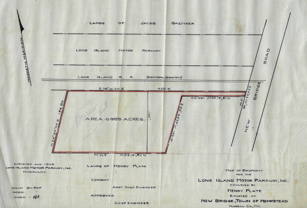
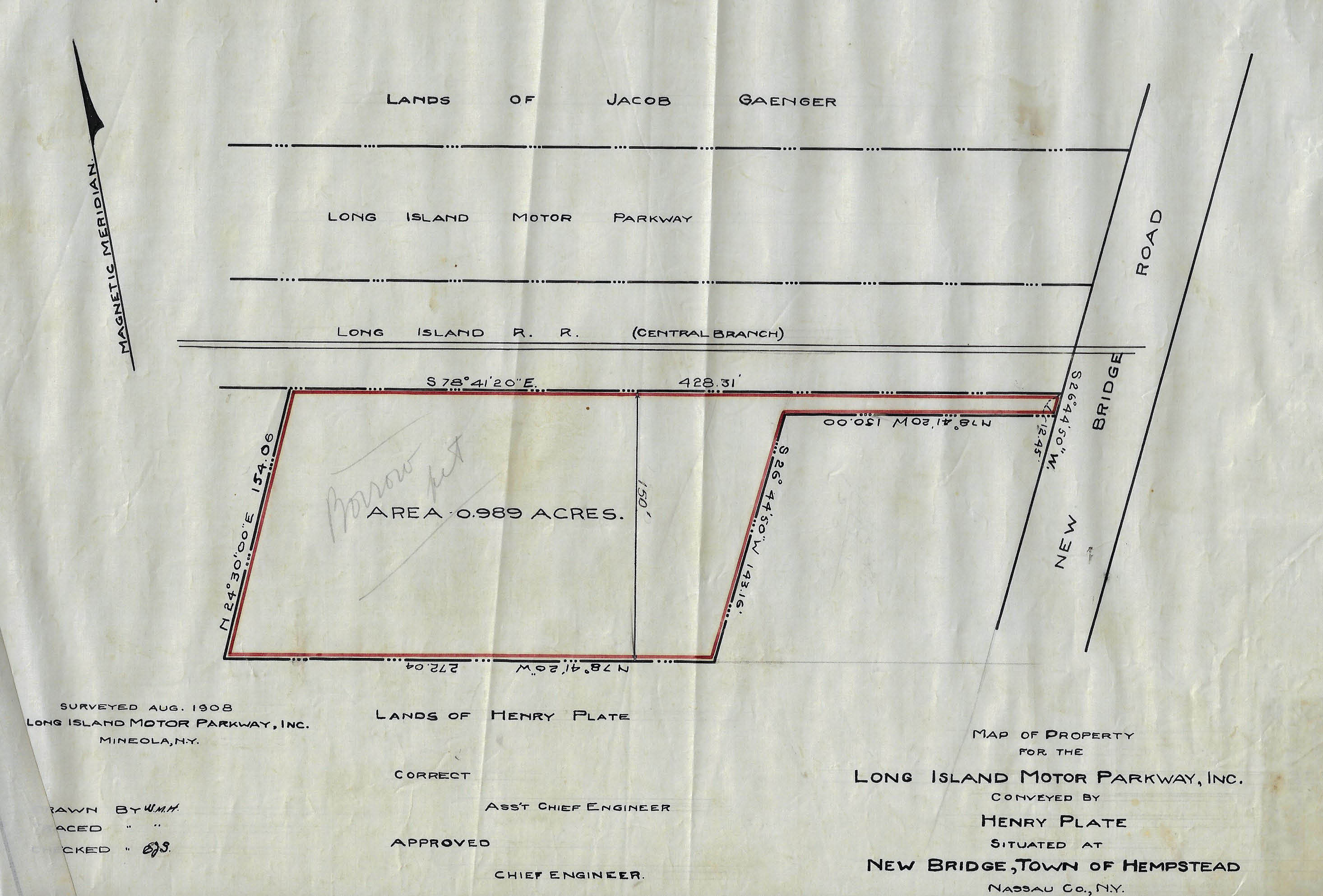
Mystery Foto #44 Solved: One-Acre Property Purchased by the Motor Parkway for a Borrow Pit
Art Kleiner challenged you to identify this weekend's Mystery Survey.
Answers to the Mystery Foto questions:
- Where was this property located?
This property was located on the west of Newbridge Road and south of the Central Rail Road tracks in the Hempstead Plains. The tracks separated the Motor Parkway from the property.
- Why did the Motor Parkway purchase this property? Provide a rationale.
The property was purchased by the Motor Parkway as a "borrow pit" where the soil and sand was used for the construction of the Newbridge Road Bridge embankments and the road.
Borrow pit, also known as a sand box, is a term used in construction and civil engineering. It describes an area where material has been dug for use at another location. Borrow pits can be found close to many major construction projects. For example, soil might be excavated to fill an embankment for a highway, clay might be excavated for use in brick-making, gravel to be used for making concrete, etc. In some cases, the borrow pits may become filled with ground water, forming recreational areas or sustainable wildlife habitats. In other cases, borrow pits may be used for landfill and waste disposal.
- What is currently on this property?
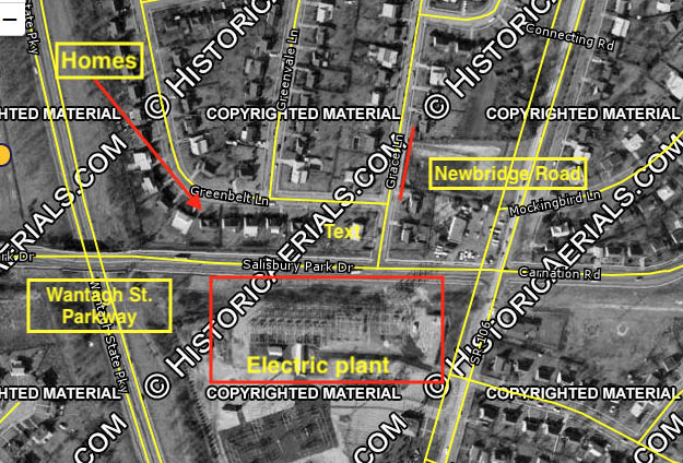
The PSE&G utility substation on Salisbury Park Drive and Newbirdge Road in Levittown as highlighted in Mystery Foto #44.
Comments (10)
Congrats to Al Prete, Pete Mann, Tim Ivers, Brian McCarthy, Ernie, Greg O., Sam Berliner III, Steve Lucas and Frank Femenias for identifying the Newbridge Road location of the Mystery Foto.
Kudos to Pete Mann, Tim Ivers, Ernie, and Sam Berliner III who identified the property's use facilitating the construction of the Newbridge Road Motor Parkway Bridge.
Enjoy,
Howard Kroplick
Close-Ups
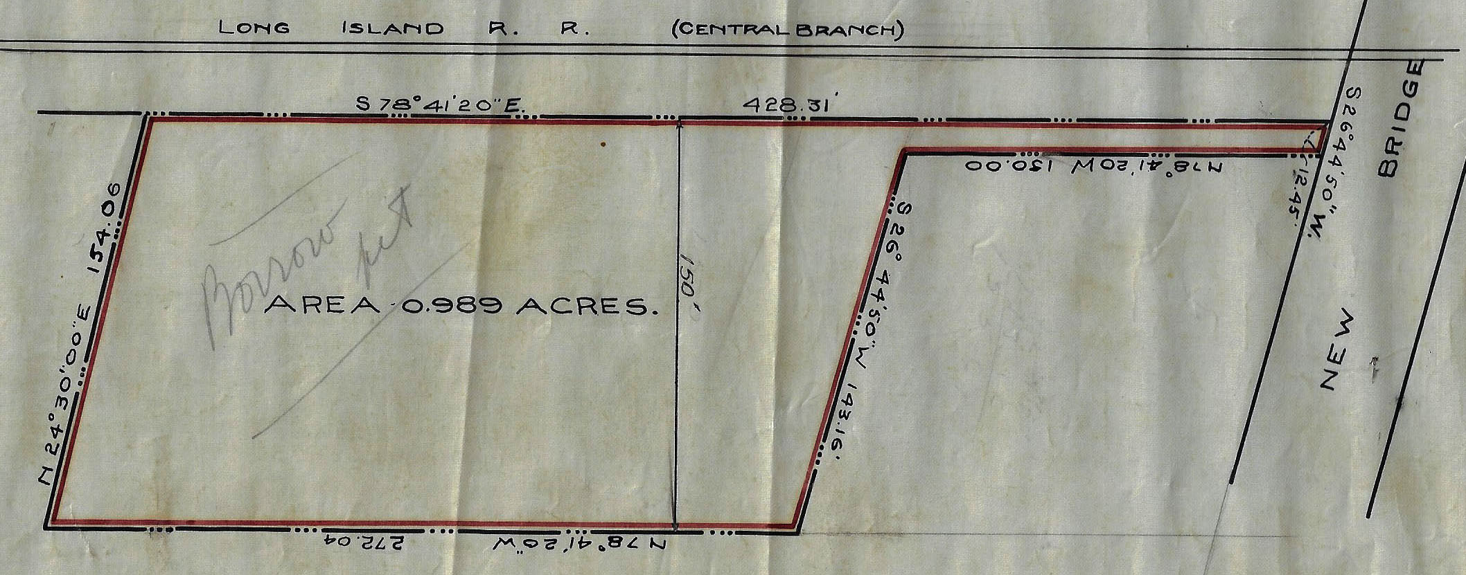
Note: The handwritten "Borrow Pit".

1926 Aerial
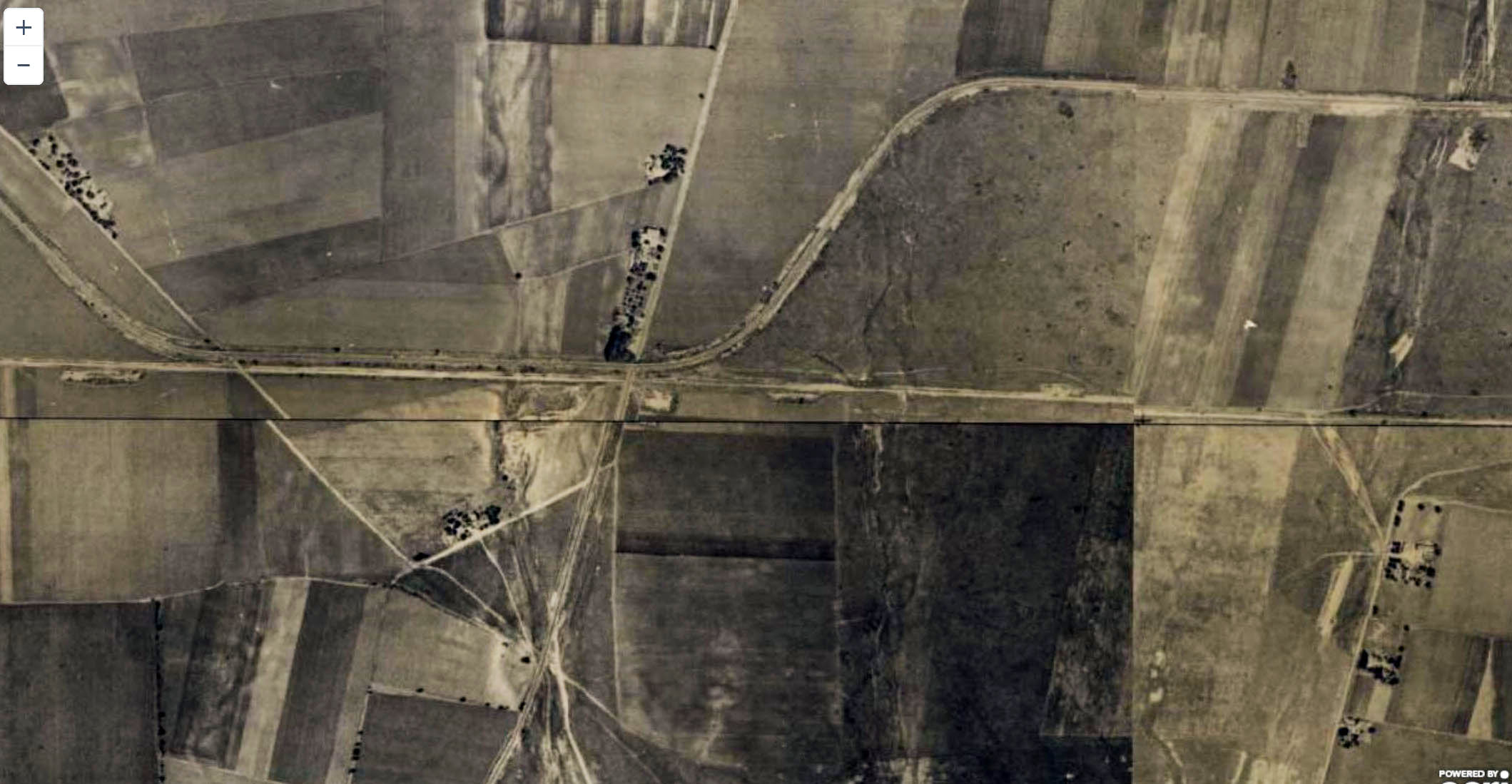
The Newbridge Road area of the Motor Parkway in 1926.
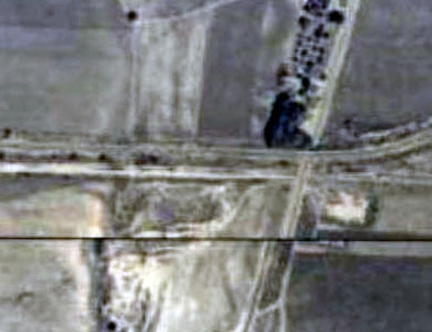
A close-up of the aerials shows the remnants of the borrow pit.
1928 Motor Parkway Atlas
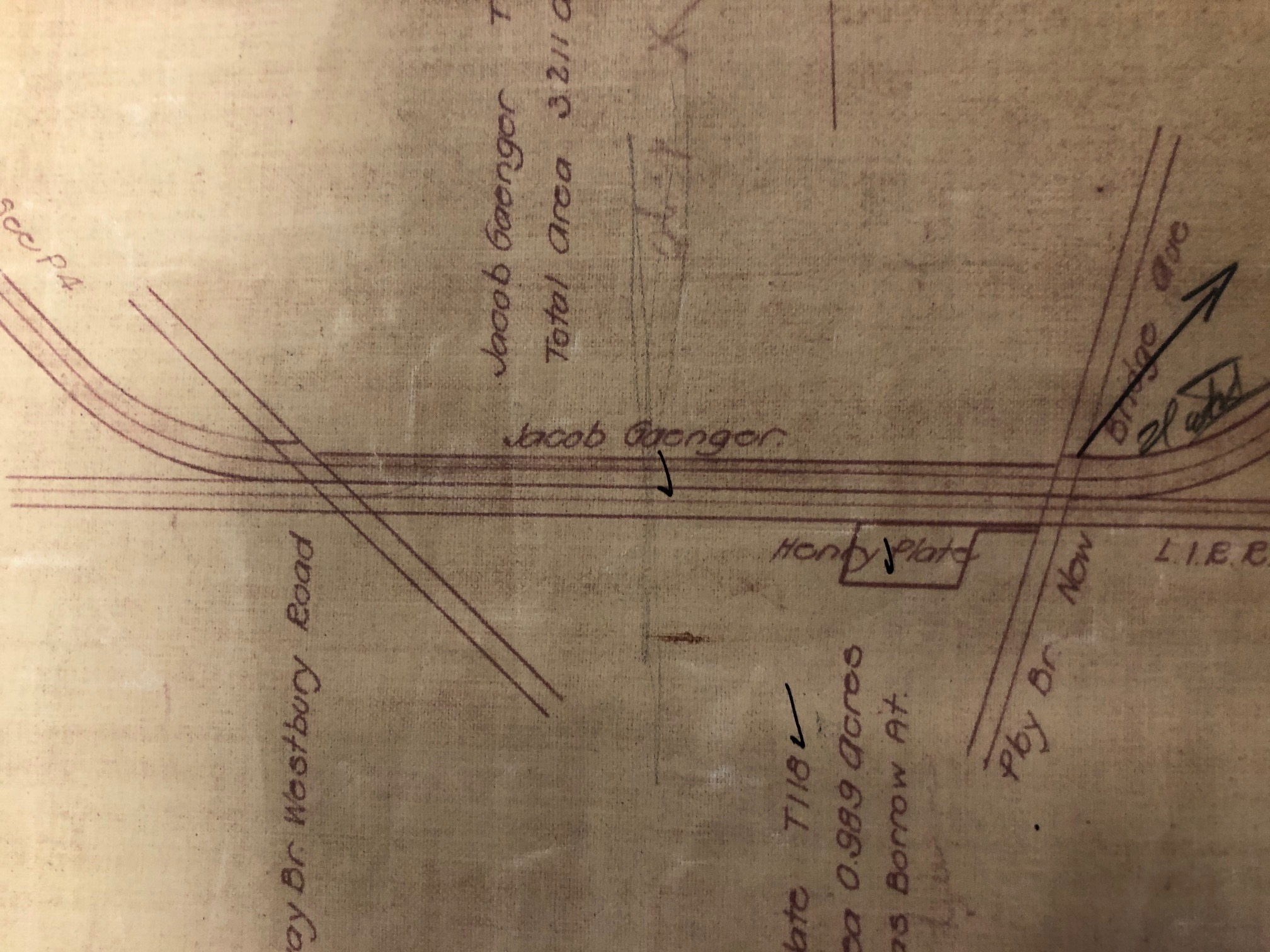
Atlas noted the 0.989 acre property was used as a "borrow pit".
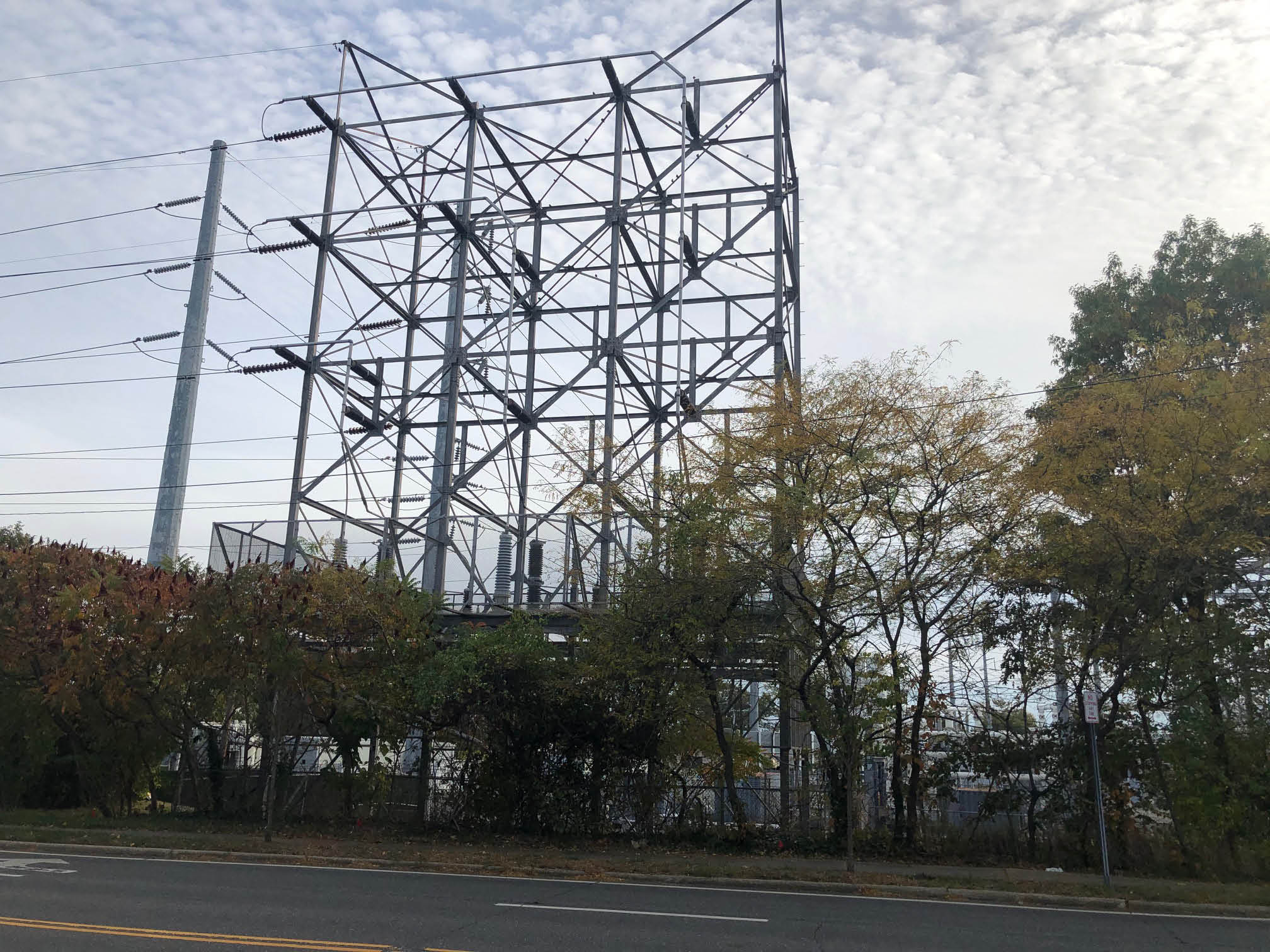
Today: The "Borrow Pit"


Comments
New Bridge (or Newbridge) is an old name for Bellmore, but this property is in the Levittown postal zone. Today, it’s the SW corner of Newbridge Road and Salisbury Park Drive. My guess is they purchased the property to build a train station. My rationale is the property is south of the Central Rail Road tracks, but the parkway is north of the tracks, and I found an old timetable of the CRR that lists a “New Bridge Road” station. The property is now occupied by an electrical substation.
It’s just south of Salisbury Park Dr and the end of my block Grace Lane in Levittown. I can only guess it was purchased to facilitate the construction of the Newbridge Rd Bridge.
The LIPA power substation is there now.
Here is some evidence that helps my hypothesis that it might have been the “New Bridge Road” railroad station: http://www.lirrhistory.com/central.html . I don’t know why the Motor Parkway would build a railroad station for another company; perhaps they had some kind of agreement to be partners.
1. South side of what was later Salisbury Park Drive and south of the Stewart rail line,
West side of Newbridge Road.
2. My guess is the LIMP purchased this acre in order to have a convenient location to dig
and use a source of dirt to construct the raised portions of the roadway in this area
between the Westbury and Newbridge Road bridges.
3. Today the LIPA transmission stations occupy the site.
Location - southwest of Newbridge Rd & LIRR
Reason for Purchase - I’m thinking the parkway company had plans for a temporarily permanent RR station to be built here for race spectators and the like. Could’ve been for the 1908 VCR, but then decided on the train stop nearer to the grandstand. Or maybe a RR station for the proposed Hempstead Plains Speedway that never came to be. Don’t think anything came of this purchased acre.
Current use - purchased by LILCO in 1938 for substation.
Where was this property located?
The property on the south side of the current Salisbury Park Drive, a little west from the intersection with the renamed Newbridge Road.
Why did the Motor Parkway purchase this property? Provide a rationale.
The engineering drawing has a penciled in comment “Borrow pit.” From Wikipedia “In construction and civil engineering, a borrow pit, also known as a sand box, is an area where material (usually soil, gravel or sand) has been dug for use at another location.[1] Borrow pits can be found close to many major construction projects. For example, soil might be excavated to fill an embankment for a highway, clay might be excavated for use in brick-making, gravel to be used for making concrete, etc.”
There were two LIMP bridges in this immediate area. The New Bridge Road bridge was situated just a few feet from the path from the pit to New Bridge. A short way west was the Westbury Road bridge. Both of these bridges were raised over the existing roads and thus required fill material to build up the embankments to the bridge deck.
What is currently on this property?
Currently a PSE&G transformer farm resides in this area. I just drove by the area and there are no indications of there being a “pit” here as the farm is all level ground. Where the material from the embankments went would be speculation on my part, though I would add the nearby Wantagh parkway does a slight dip under Salisbury Park Drive, so at one time there was plenty of nearby material to use to level this area.
I sized the drawing to approximately match a Google Map of the area and pasted the drawing in.
West of Newbridge Rd (106). Currently the site of a LIPA substation. Not sure why it was purchased, but maybe they were considering on constructing a railroad station.
Well, it states right on the plan that it was a “Borrow Pit” and so probably furnished fill for the Newbridge Road bridge abutments.,. It’s at the east end of today’s Salisbury Park Drive, opposite the west end of today’s Carnation Road, and is now the site of LIPA’s power substation distribution tower. Sam, III
Obviously the property is slightly west of Newbridge Road in Levittown with access to
Newbridge Road. Since the LIRR Central Branch ROW is between the LIMP and the site, could there possibly have been some joint plan in the works to build a combo lodge and railroad station? The site is about midway between Meadowbrook and Massapequa lodges. Today there a large PSE&G substation on this site.
The 1 acre property is in Levittown, where the electric substation is on Newbridge Rd, but the station has grown today to 7.5 acres. Dunno the reason for purchase but three possibilities;
1. The lot was included with a RoW property purchase just to the north (unlikely).
2. The lot was purchased to serve as an intermediate fuel service/tire change station during the races (more likely).
3. The lot was purchased to serve as a parking facility for race spectators observing from the top of the Newbridge Hotel, on Newbridge Rd just to the north, a favorite viewing site for the races (most likely).
By 1936 the lot was already being used as a substation while the LIMP was still in operation (see below).
Anticipating this week’s answers. The stress is wearing out my timing chain. Hurry up!
PS. Check out the steepness of the Newbridge Rd bridge below! It reminds me of the bridges still standing in Queens on the Brooklyn-Queens Greenway.
Look at that, the answer was (and still is) there for all to see.
Great historic reference by all! Thank you Howard and everyone for your contributions.
Good information all around. Love that last pic, Frank! I just obtained my latest FOIL request back from the NYSDOT regarding the building of the Wantagh State Parkway in the area for a future blog post. Here’s two from 1936 and 1952 showing the outline of the borrow pit.
Pete M. - I see you’re on Grace? I’m on Norman just north of you. Want to compare notes sometime?
Frank Femenias picture of the New Bridge Road overpass has several details that I particlarly like. Peeking above the left side embankment is first a square old style rail road crossing sign. Also there are two poles with a single cross-arm off one side of the pole only; these are used for an overhead power wire.
In 1908 the Pennsylvania Railroad electrified this portion of the Stewart line from Garden City to test various ways to power electric trains. This was important as they were building Pennsylvania Station in NYC and needed electric engines there.
Source: http://arrts-arrchives.com/newpage1.html
Ernie - I believe the image below, a little further west from Newbridge, shows the catenary run from Garden City. Interesting stuff!
OMG! Some LIRR/PRR historian *I* am! Fantastic find! Thanks, Frank, Brian, and Ernie! Lotsa!!!! Sam (the chastened), III