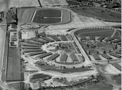
Mystery Foto #38 Solved:Roosevelt Raceway, Meadow Brook Polo Field & Roosevelt Field Updated 1/24/16

Lee Chambers challenged you to identify this amazing Long Island aerial.
Answers to Mystery Foto questions:
- Identify the location of the aerial
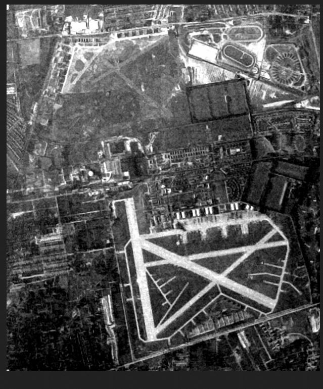
The aerial was taken looking north and west over Westbury, now considered East Garden City.
Identify the areas and structures dedicated to sporting events
The original Roosevelt Raceway complex for harness racing, grandstands, track, practice track and paddocks, can be seen on the right. The grandstand was originally built for the 1936 and 1937 Vanderbilt Cup Races.The Meadow Brook Polo fields can be seen on the left.
- Identify the airfield in the background
Roosevelt Field which closed on May 31,1951.
- What is the housing community on the lower left corner of the aerial?
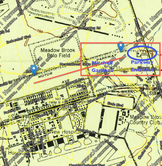
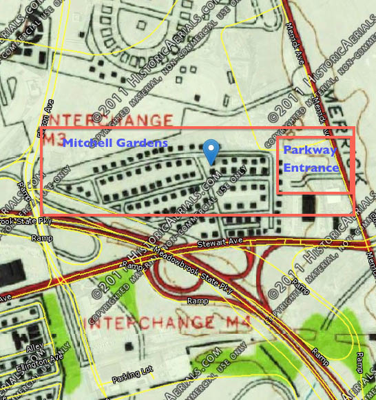
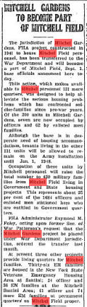
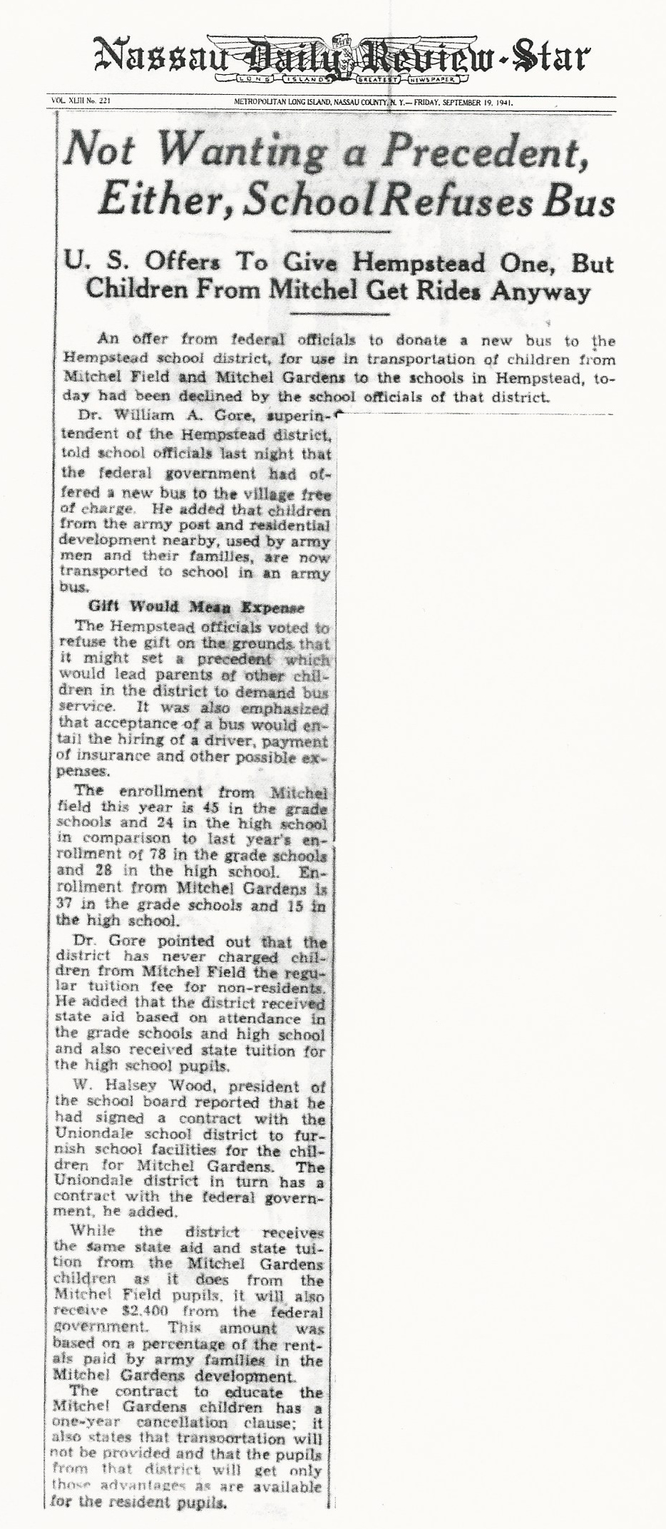
Mitchel Gardens, a FHA project built in 1941 to house Mitchel Field personnel. In 1947, the community was transferred to the War Department to become part of Mitchel Field. The entire complex was partially taken down around 1955 to make way for the Meadowbrook Parkway right-of-way. The rest of the complex came down around 1966.
- What are the structures built in a circle on the right?
The paddock and stable circle of Roosevelt Raceway.
- Identify the major roads seen in the aerial
The remnants of the Long Island Motor Parkway can be seen on the left corner of the aerial just above Mitchel Gardens. Old Country Road runs across the diagonal on the right. Kenwood Avenue, Linwood Avenue and Willow Street can be seen in Mitchel Gardens.
- What is the approximate date of the aerial? Provide a rationale.
The aerial was taken around 1950 before the Meadowbrook Parkway was built and Mitchel Gardens was partially taken down in 1955.
Congrats to Tim Ivers, Sam Berliner III,Greg O., Steve Lucas, Art Kleiner (see below Kleiner's Korner), Mark Lanase, Michael LaBarbara, and Frank Femenias for identifying Roosevelt Raceway. Kudos to Sam Berliner III, Tim Ivers, Greg O., Steve Lucas, Frank Femenias and Art Kleiner for identifying Mitchel Gardens which became a housing community for Mitchel Field.
Enjoy,
Howard Kroplick
Closeups
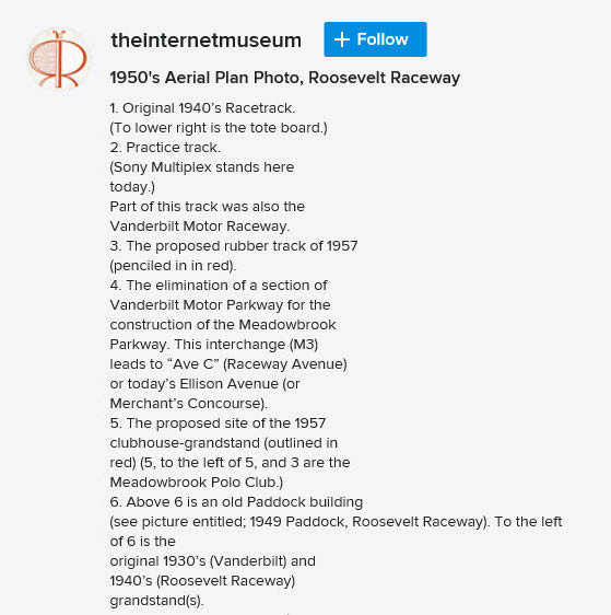
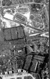
The Roosevelt Raceway complex.
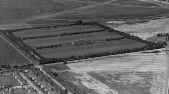
The polo fields of the Meadow Brook Polo Club. Note the polo grandstand and the Motor Parkway.
Look closely and you can see the Roosevelt Field Motor Parkwat Bridge.
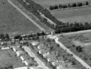
Mitchel Gardens is on the left.
1950s Aerial of Roosevelt Racway
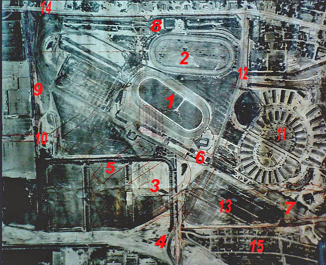
Courtesy of theinternetmuseum
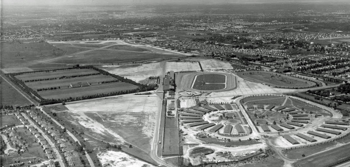
1960s Aerial
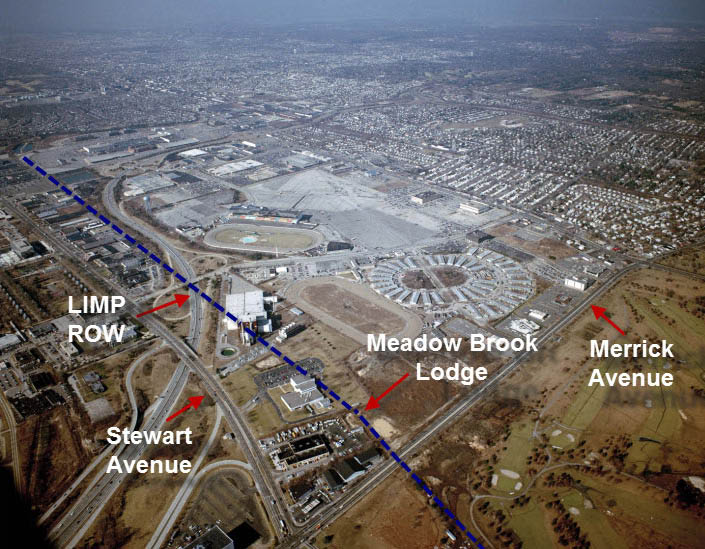
As seen in this 1960s aerial, there was no trace of Mitchel Gardens between Stewart Avenue and the Motor Parkway right-of-way after the Meadowbrook Parkway was opened.
Kleiner's Korner (Submitted by Art Kleiner)
1947
1948 Aerial
1948 Aerial Closeup
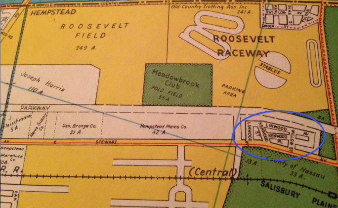
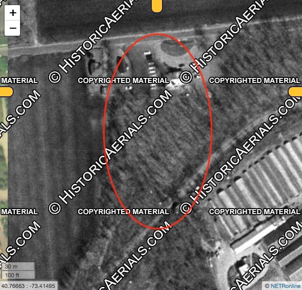
1950 map showing the streets of Mitchel Gardens; Linwood Avenue, Kenwood Street, Kenwood Place and Willow Stre.
1957
1966
2013
2015
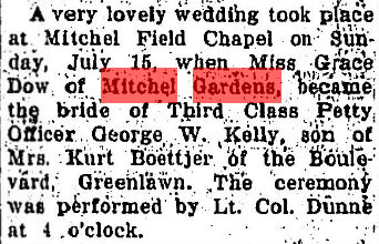
Long Islander, July 26, 1945
Essex County Republican, October 19,1945
Long Islander, August 14,1947
"Mitchel Gardens, a FHA project constructed in 1941 to house Mitchel Field personnel. has been transferred to the War Department and will become part of Mitchel Field on September 1 (1947)."
Submitted by Lee Chambers
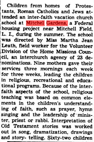
Here's a mention of Mitchel Gardens soon after it was created in 1941 that I ran across with respect to the children living there and where they would wind up going to school.
The article suggests that elementary aged kids went to Uniondale schools (I'm guessing California Avenue, built in 1928 and originally named, 'East Hempstead Elementary School' and where I later went as a child, then went to Hempstead HS until Uniondale HS was opened in 1954.
This meant there were civilian children at Mitchel Gardens going to Uniondale and/or Hempstead schools. The Federal Government subsidized the military kids going there and apparently NY State did the same for the civilian kids, at least until the Gardens was transferred to Air Force control in 1947 when there were nothing but military kids there.
This had implications for the future after the Base was decommissioned. Undoubtedly, the Navy continued subsidizing military kids. As for the civilian kids of NCC employees living on the former Base such as myself, I would surmise NYS continued to foot the bill.


Comments
Belmont Park, Opened May 4, 1905?
Looking northwest about 1950 at the Roosevelt Field and Raceway area. Roosevelt Field in the top left background (airfield). Center right is the oblong auto racetrack; to the right of that is the practice auto racetrack. The circular structures at lower right are the horse paddock areas. Lower left is housing at Mitchel Field. Old Country Road runs diagonally from middle right to top left, along the right side of Roosevelt Airfield.
Correction: The oval track at the middle right is the horse track, NOT auto; ditto for practice track.
I’ve been searching on and off for two days and I hope I got this right,not all of it,but maybe something. Mitchell Field and Roosevelt Field in I would say 1936,but I’m not even sure about that,because there’s so many structures,that I’m not able to identify,it might be more recent than that
location - over southern Salisbury (today’s Eisenhower) Park on the Hempstead Plains looking LI west (compass WNW); sporting - Old Westbury Golf Club at upper left, Meadowbrook Polo Field(s - 3) to club’s lower right, Roosevelt Flying Field to upper left of dead center, Roosevelt Raceway filling lower right quadrant; and Mineola Fair lost in haze in center distance; airfield - Hazelhurst #1-cum-Roosevelt Flying Field #1-cum-Roosevelt Field; housing community - Mitchell Gardens (USN); structures built in a circle - stables for Raceway; roads - LIMP at top, just beyond Glen Cove (Guinea Woods) Road (far end of R. Field) and then diagonally across lower left, Old Country Road as right (N) boundary of both fields, Jericho Tpke. beyond OCR over LIRR tracks, No. State Pkwy at top and looping at upper right, with No, Blvd. in haze beyond that, and Raceway entrance road from LIMP at left, Whaleneck Rd., and Merrick Ave. across lower right, AND, if you could see through the haze, U. S. Rte. 1 in Westchester across the Sound; date/rationale - 1936 because first Geo. V. Cup course is there to the right of harness track. Whew! So, there! Sam, III
Oops - Glen Cove/Guinea Woods Road is Clinton Road down there! Sam, III
Identify the location of the aerial
Looking West towards Roosevelt Field/Mineola/Garden City approximately over present day Eisenhower Park
Identify the areas and structures dedicated to sporting events
Roosevelt Raceway horse track, Meadowbrook Polo Club, Intercollegiate Golf Club/Old Westbury Club
Identify the airfield in the background
Roosevelt Field
What is the housing community on the lower left corner of the aerial?
Housing for Mitchel Field
What are the structures built in a circle on the right?
Horse Paddocks for Roosevelt Field
Identify the major roads seen in the aerial
Motor Parkway, Old Country Rd, Clinton Ave
What is the approximate date of the aerial? Provide a rationale.
Mid 1940’s due to the development of Roosevelt Raceway Horse track, but long before the Meadowbrook parkway in the ‘50s.
I’m gonna guess cuz that’s all I can do.
1. western edge of Mineola LINY
2. East Meadowbrook race track
3. Mitchell Field http://www.airfields-freeman.com/NY/Airfields_NY_LongIs_Nassau.htm#Mitchel
4. I got nuthin’.....Roosevelt Acres?? Said I got nuthin’.
5. Horse stables
5. Meadowbrook Pkwy.
6. 1937
The photo is looking northwest over Westbury from a position approximately over Merrick Ave. just south of Old Country Road. Sporting event areas include the Meadowbrook Club polo fields and 2 Roosevelt Raceway harness tracks (main & practice). The airfield in the background is Roosevelt Field. The community on the lower left is the military housing for Mitchel Field. The circular area on the right is the paddock circle and horse barns. Major roads include the LIMP, Old Country Road, Clinton Road and possibly the Northern State Parkway in the upper right corner. Judging by the relative completion of Roosevelt Raceway but lack of activity at the track, I believe the date is probably close to the track’s opening on Sept. 2, 1940.
Howard - I might have already submitted a reply (falling asleep at the computer makes me wonder if I actually pressed the submit button the first time around) plus I updated some of my answers below.
Identify the location of the aerial: Garden City
Identify the areas and structures dedicated to sporting events: Roosevelt Raceway practice and real tracks, Roosevelt Raceway Grandstand, Motor Parkway Old Country Road Bridge, Meadowbrook Polo Field
Identify the airfield in the background: Roosevelt Field
What is the housing community on the lower left corner of the aerial?
Mitchel Gardens (see documentation being sent to Howard)
What are the structures built in a circle on the right?: Stables/Paddock
Identify the major roads seen in the aerial: Motor Parkway, Old Country Road, Clinton Avenue, small section of Merrick Avenue
What is the approximate date of the aerial? Provide a rationale. 1950; new grandstand wasn’t built until 1957. Meadowbrook Polo Club moved in 1954 due to the building of the Meadowbrook Parkway. A 1948 photo being sent Howard does not show a row of stables.
Roosevelt Field, Polo fields, LIMP Roosevelt Racetrack
We have the Roosevelt Raceway looking northwest from Merrick Avenue (lower right) . In this picture we can see the grandstand and track (1940 to 1956), the Test track at Old Country Road and the Meadowbrook Polo Grounds to the left center of picture. This borders the Long Island Motor Parkway to it’s south and Stewart Avenue running parallel. The round structures are the stable paddocks and I can only guess that the community of houses to the left were homes for the staff and jockeys (now part of the Meadowbrook Parkway). The airfield to the top of picture is Roosevelt Field at the corner of Clinton Ave and Old Country Road. The approximate date for the picture must be between 1940 and 1954 after the construction of the Polo Fields and before the construction of the Meadowbrook Parkway…..my particular guess would be 1940 because everything looks so new in the photograph, it may have been opening day.
1950’s Westbury looking NW at Roosevelt Raceway harness racing, with circular paddocks bottom right. Garden City and curvy Motor Pkwy on bottom left with twin bridge location site (future Merchant’s Concourse). Barely seen in the distance is LIMP’s Mayan Ruins, Old Country Rd hwy bridge, LIRR pkwy bridge, Westbury Ave pkwy bridge, Hillside Ave pkwy bridge into Wheatley Hills golf course. Need an electron microscope to go further. Garden City lodge and Clinton Ave bridge are out of view in top left. In the center looks like remnants of ‘30s Vanderbilt and ‘40s Roosevelt raceway grandstand, Meadowbrook polo club grounds middle left, Roosevelt airfield behind the polo grounds (remaining white aircraft hanger can be seen by Old Country Rd). Merrick Ave (Whaleneck Av) bottom right corner, Old Country Rd diagonal across the center, Clinton Rd-Glen Cove Rd (Guinea Woods Rd) furthest edge of Roosevelt airfield. Housing community is Mitchel Airfield base (northern airfield boundary) and just east of future Meadowbrook Pkwy. Main raceway in the center is original ‘40s racetrack, to the right is a practice track and future site of Sony Multiplex (part of this track was the original Vanderbilt motor raceway).
2 questions if I may Howard,
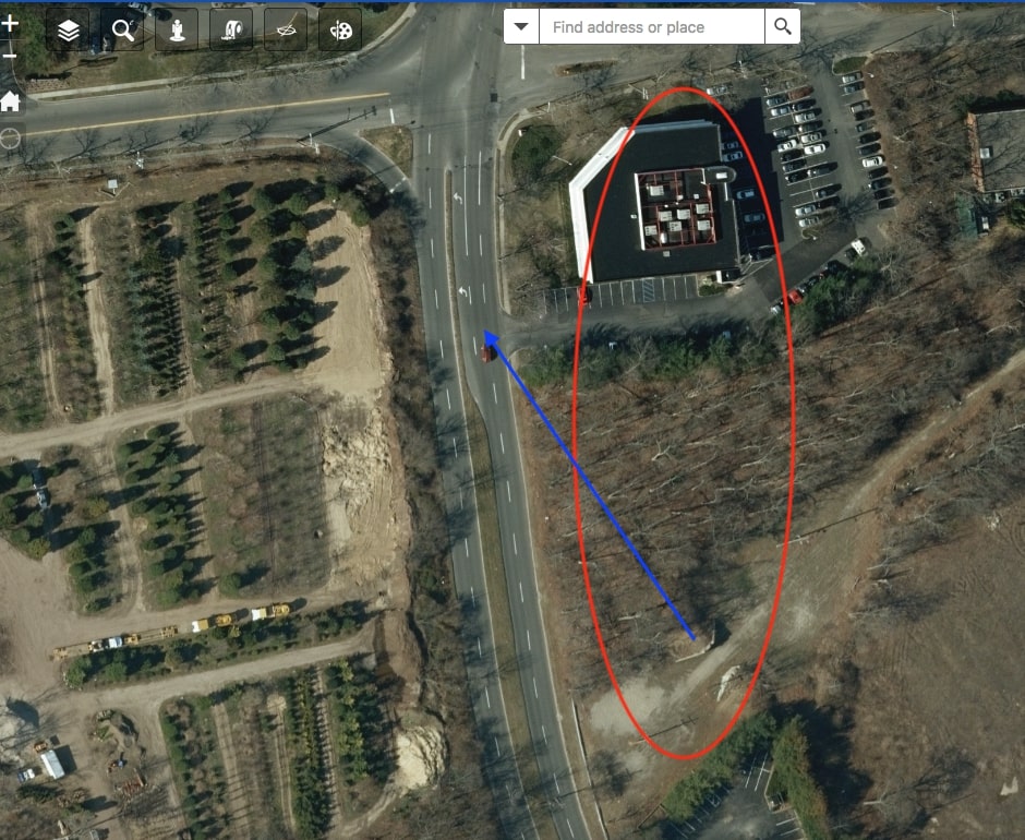
1st question is the path of the actual Motor Parkway as seen in the current photo… is the illustrated line up the driveway to the office building the actual entrance to the Meadowbrook Lodge, and isn’t the actual path of the Motor Parkway the service road between Micro Center and the Air Traffic Control (please clarify) and
2nd question which has plagued me about this area…. is the original motor parkway bridge at ellison ave north or south of today’s bridge ?
Thanks, Mike
________________________________________
From Howard Kroplick
Yes, the driveway to the bank’s parking lot matches the entrance road to the Meadow Brook Lodge. I have added a 1960s aerial of the area which shows the approximate path of the Motor Parkway.
http://www.vanderbiltcupraces.com/blog/article/the_motor_parkway_toll_collection_structures_9_meadow_brook_lodge_in_westbu
There has been great debate in the past about the location of the Roosevelt Field Motor Parkway bridge(s). I will research it in a future September post:
http://www.vanderbiltcupraces.com/blog/article/long_island_motor_parkway_bridge_series_33_the_roosevelt_field_motor_parkwa
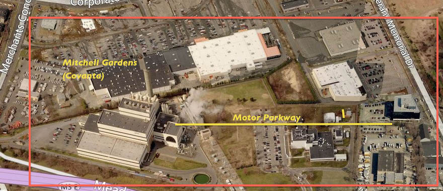
Howard thanks for that link, in looking at Wayne Consola’s map of the Meadowbrook Parkway, his line for the Motor Parkway Ellison Ave bridge runs east west, just slightly north of the bridge (between the entrance and exit ramps at the Covanta entrance), however there was a bend in the parkway slightly southward before the lodge, which may indeed place the original bridge slightly south of the existing bridge…...get out the surveyors scopes !!! Mike