Mystery Foto #33 Solved: The World’s Largest Map of Long Island Located at Mepham High School
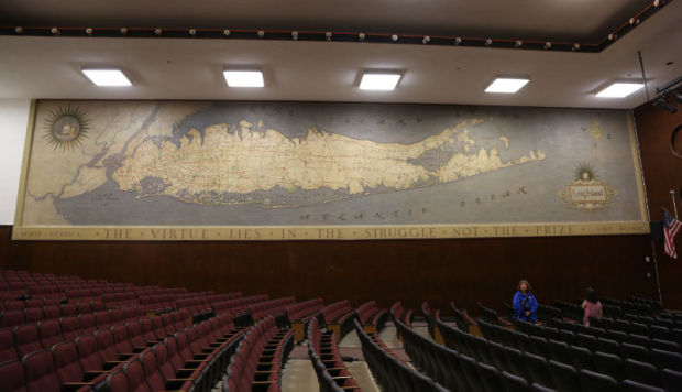
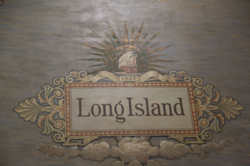
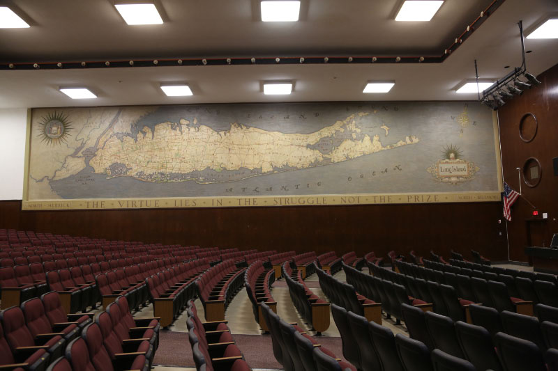
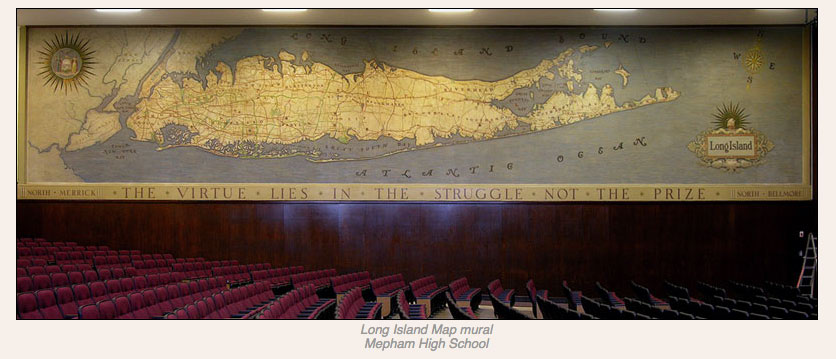
Last weekend's Mystery Foto was one of my all-time favorites- an 16-foot x 80-foot 1937 map. It is the world's largest map of Long Island and the Long Island Motor Parkway.
Mystery Foto questions:
- Where is this map located?
The map is part of a mural located in the auditorium of Mepham High in North Bellmore. The school's dedication was held in the auditorium on September 8, 1937. Since there no mention of the map, it is unlikely it was installed in time for the dedication. The maxim under the map “The virtue lies in the struggle not the prize” quotes Richard Monckton Milnes (1809-1885).
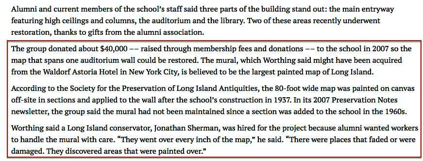
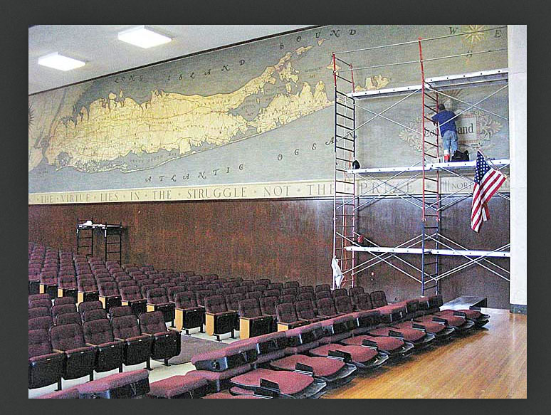
The mural was restored in 2007 by painting conservator Jonathan Sherman who has forwarded details on the map:
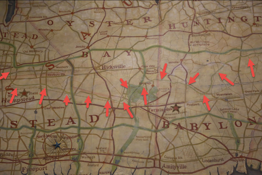
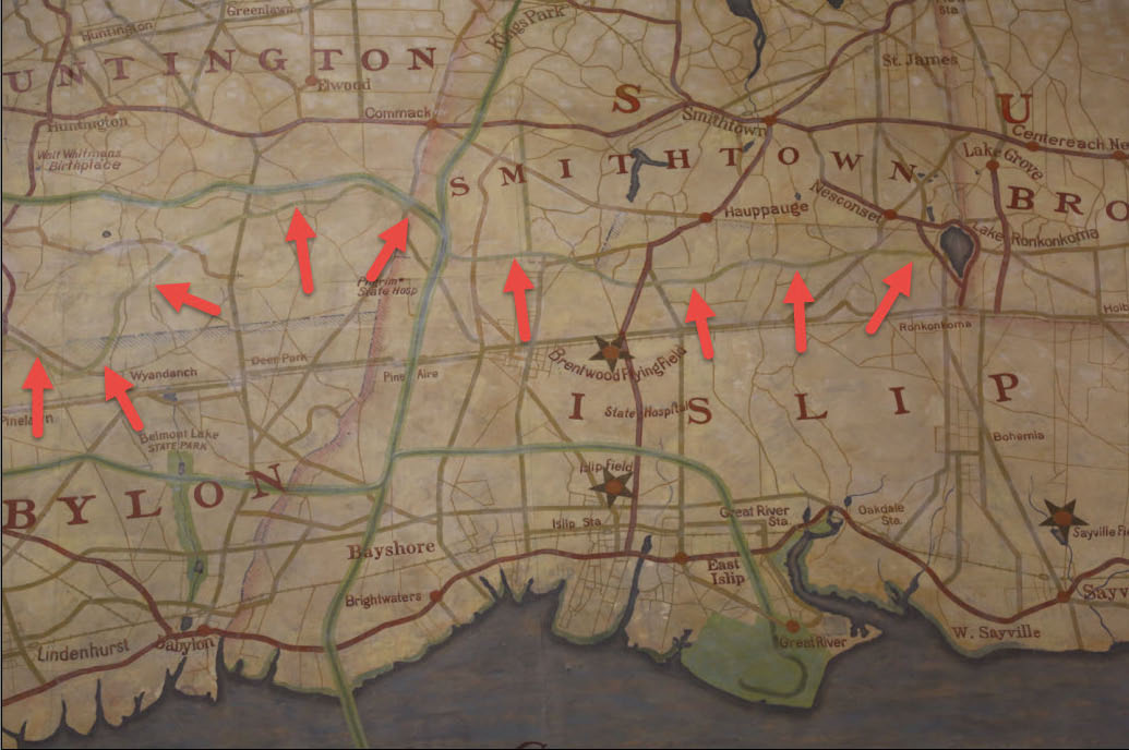
The mural covers a section of the wall 16 x 80 feet. The map is painted in oil paint and was completed in 1937 as identified by a date on the legend in the lower right. The construction of the mural is a bit complicated but I believe it was put together in the following manner:
1. The entire wall was covered with canvas, adhered with a strong adhesive, possibly white lead oil paint (a commonly used adhesive for canvas murals from this period).
2. The map portion of the mural was adhered in strips approximately 40 inches wide to the canvas with the same adhesive. The map was painted in oil paint on thin paper adhered to a thin canvas. many of the seams are cut roughly and unevenly. In places there are minor gaps between the sections.
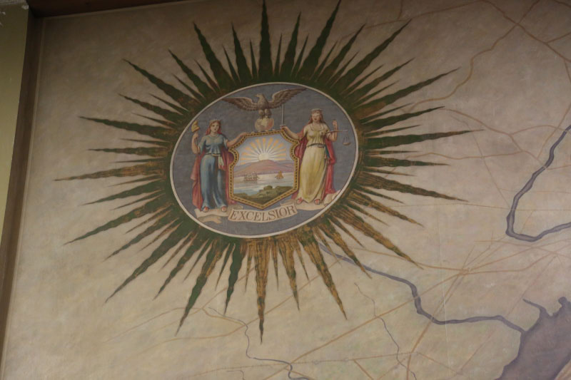
3. The entire wall was painted. The map was repainted over an earlier map with larger lettering and a greater focus on Long Island (many details of New York City and New Jersey were painted out). The sections around the map were painted directly on the canvassed wall. The sections representing the water around Long Island were painted over a textured preparation which was grooved to simulate water. The legend and title of the map in the lower right was painted on the canvas as was the compass above. The Seal of the State of New York was added, painted on the original paper/canvas map. A raised plaster star was placed at the location of Mepham High School .
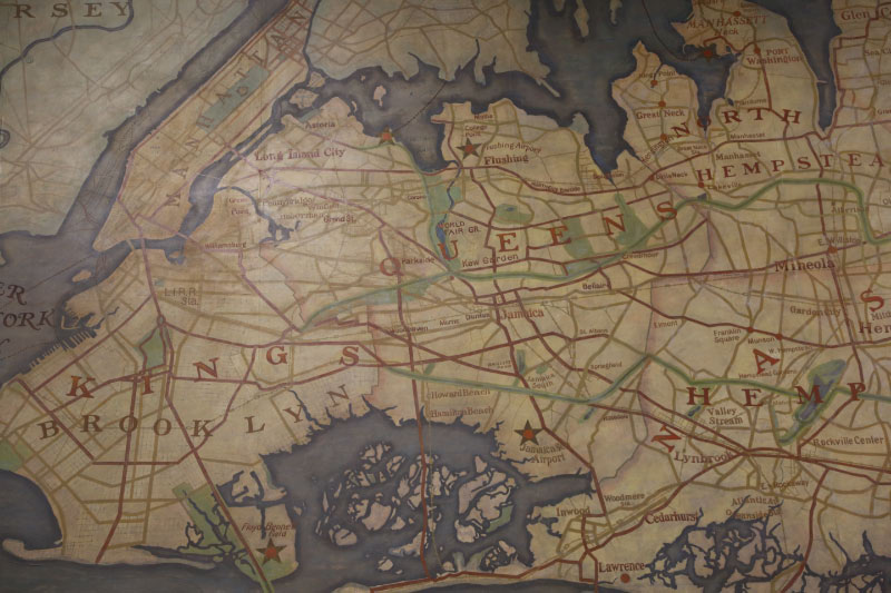
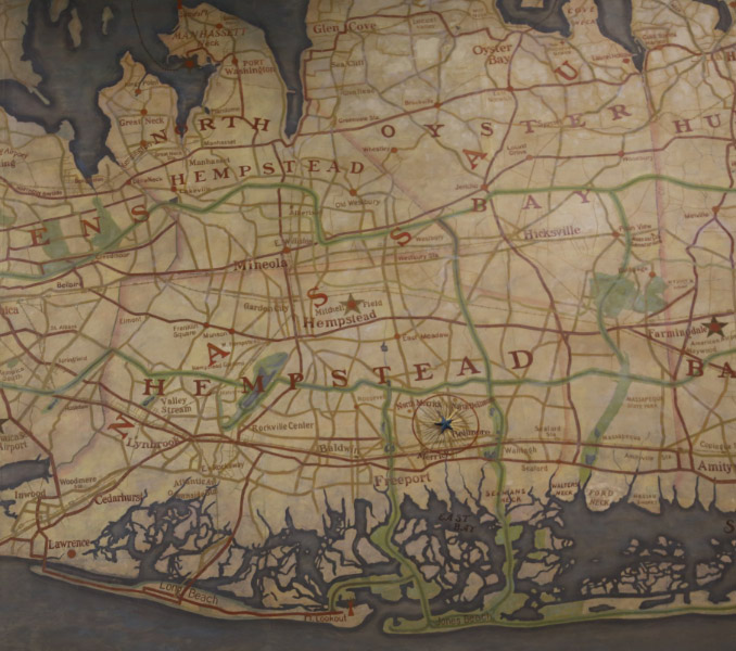
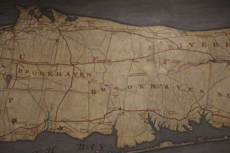
- Identify the villages on this map that were originally misspelled or incorrectly named?
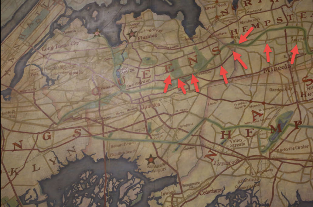
East Meadow (East Meadaw)
Kew Gardens (Kew Garden)
Rockville Centre (Rockville Center)
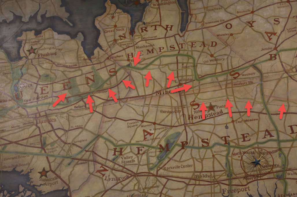
Sweezy (Swezy)
- How many airfields are identified on the map marked with a star?
Queens (4)
-North Beach Airport (marked only by a star, later became LaGuardia Airport)
-Jamaica Sea Airport (later became part of Kennedy International Airport)
Nassau County (3)
-Sands Point Seaplane Base (identified only by a star)
-American Airport (later Republic Airport)
Suffolk County (7)
-Islip Flying Field (later Long Island MacArthur Airport)
-Suffolk Airport (later Francis S. Gabreski Airport)
-Montauk Point Field (later Montauk Airport)
- What do the dotted lines seen on the Long Island Sound and bays represent?
The Long Island ferry lines
- What is the history of this map?
Jonathan Sherman believes the map was created by Rambusch Decorating Company initially for the new Waldorf Astoria Hotel on 50th Street, where it highlighted the golf courses and country clubs of Long Island. It was relocated to Mepham High School in late 1937 or 1938 and repainted focusing on the airfields of Long Island (marked by stars).
Comments (11)
Congrats to Cheryl Lynn Blum, Art Kleiner, Steve Lucas, Brian McCarthy, Dick Gorman and Bob L for identifying Mepham High School as the location for the map. Kudos to Art Kleiner, Cheryl Lynn Blum and Steve Lucas for forwarding the below documentation on the map.
Enjoy,
Howard Kroplick
Mepham High School, North Bellmore
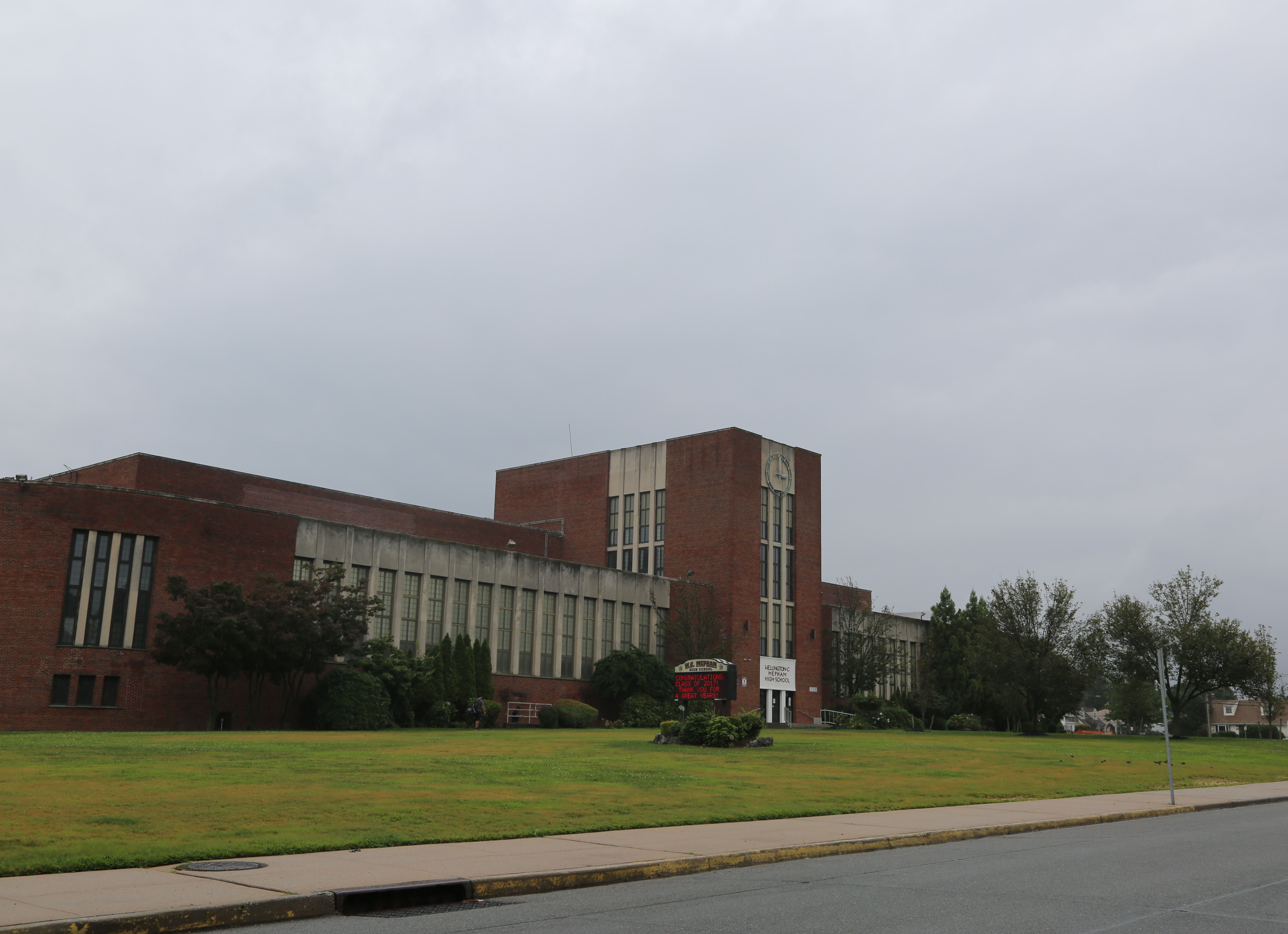
The architect for the beautful Mepham High School was Wiedersum Associates Architects, a family-owned firm still in business today. Mepham High School "set the tone for secondary educational facilities throughout North America and Europe."
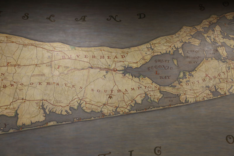
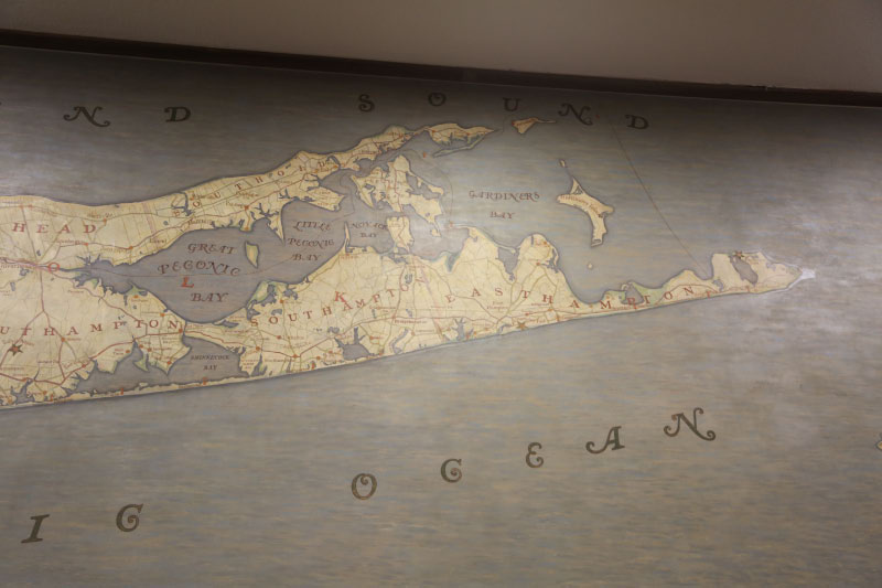
Queens
Nassau County
Suffolk County
Close-Ups
The Long Island Motor Parkway
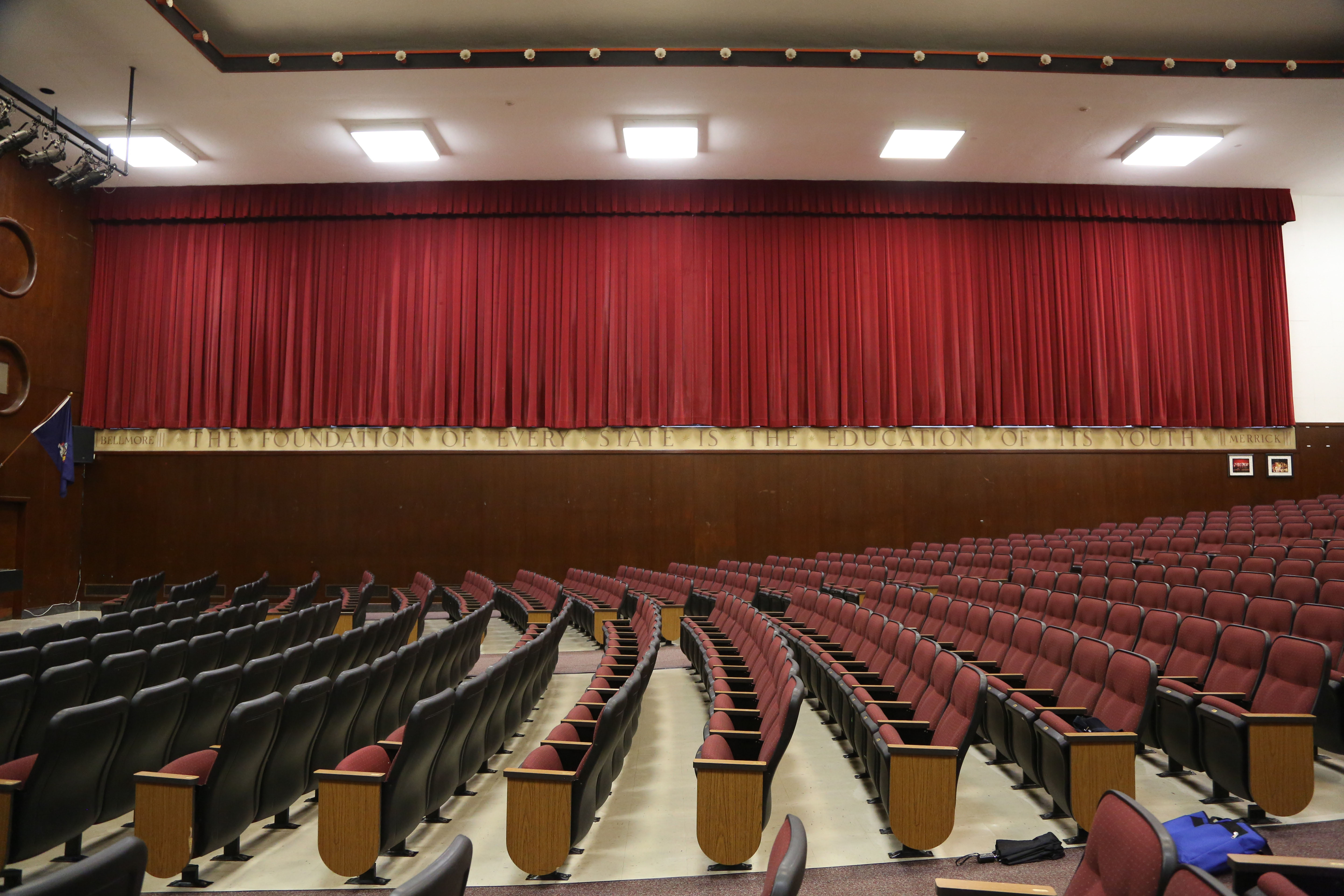
On the opposite side of the mural is a maxim from Diogenes of Sinope: "The Foundation of Every State is the Education of Its Youth."
Kleiner's Korner (Submitted by Art Kleiner)
LI Herald September 12, 2012
Lucas' Learnings (Submitted by Steve Lucas)
LI Herald October 4, 2007
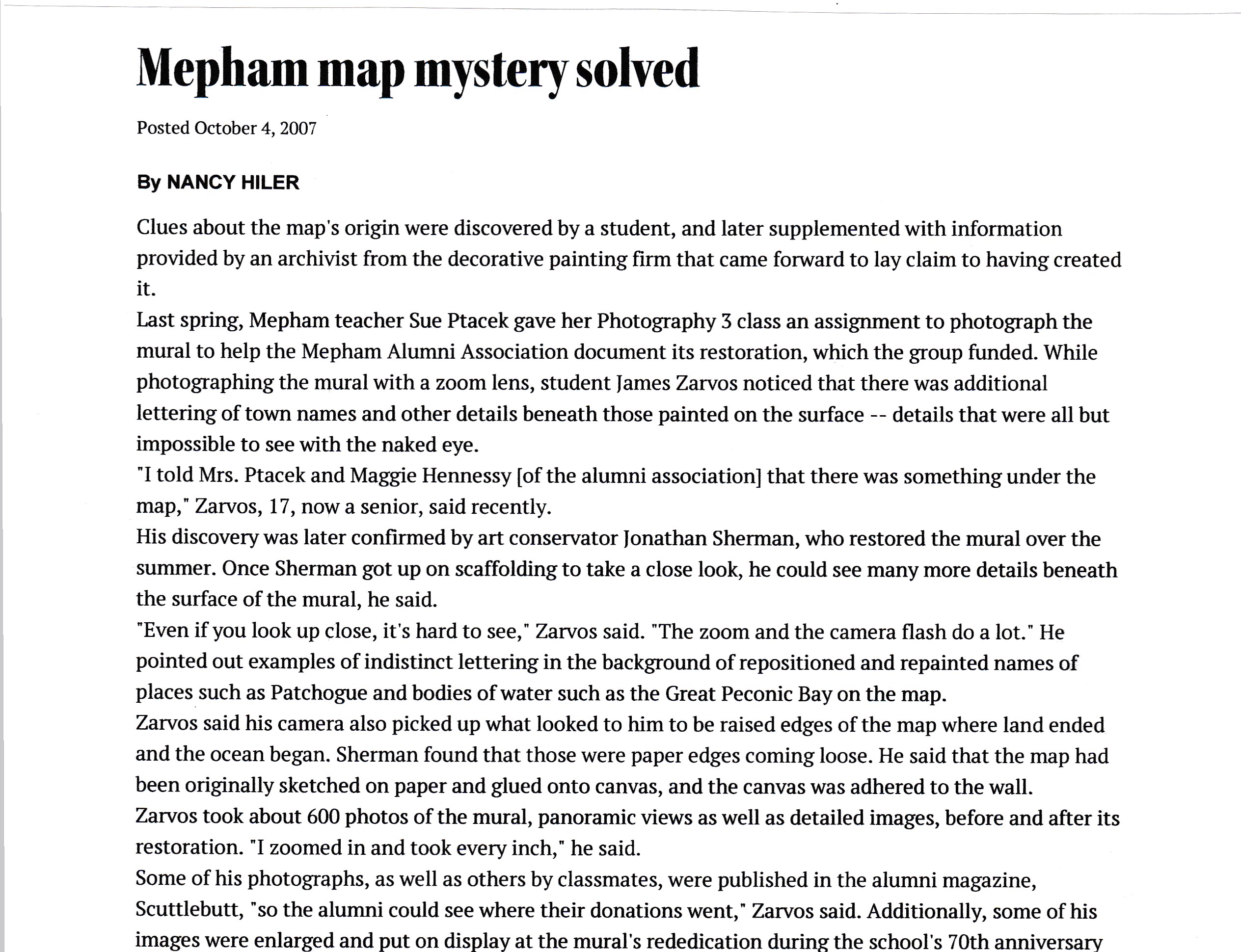
"While photographing the mural witha zoon lens, student James Zarvos noticed there was additional lettering of town names and other details beneath the surface... His discovery was later confirmed by art conservator Jonathan Sherman, who restored the mural over the summer."
" a family-owned, Manhattan-based decorative painting firm, Rambusch Decorative Sudio, founded in the 1870s, created the map."
The new "Waldorf-Astoria Hotel was built at 50th Street between Park and Lexington avenues in 1931, and the map was created as a mural for one of its restaurants, the Norse Grill. (The restaurant is now the Bull and Bear.)"
"The mural...was a map of the environs of New York City, Long Island, highlighting locations of country clubs and golf courses."
"The hotel manager...felt the map didn't fit with the theme he wanted."
The map was repainted and probably moved to Mepham High School shortly after it grand opening in September 1937.


Comments
Mepham High School: http://liherald.com/stories/Preserving-Mephams-and-LIs-past,4939
Map is in the auditorium of Mepham High School in North Bellmore. Some clues leading my investigation were mentions of North Bellmore and North Merrick on the bottom part of the frame and those villages being highlighted on the map. A good friend’s kids graduated from Mepham - have to ask them about it.
Dotted lines would be ferry crossings.
I see Plainview shown as Plain View, didn’t do much more examining.
Airfields: 9 (possibly 10)
Flushing Airport, Jamaica Airport, Floyd Bennett Field, Mitchell Field, American Airport (a.k.a Seversky Airport), Islip Airport, Brentwood Airport, Patchogue Aiport, Suffolk Airport (Southampton) and my possibility making 10 would be the Montauk Seaplane area (also may have been marked by a star).
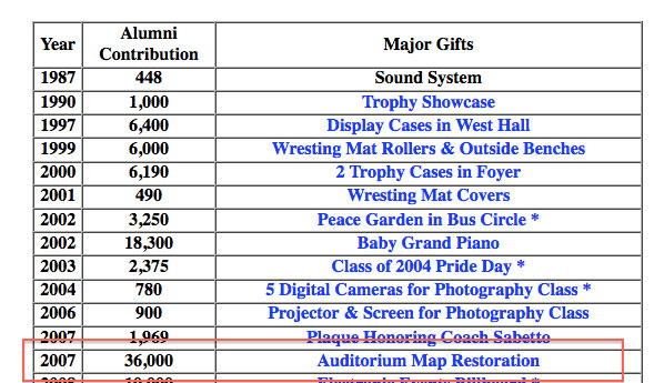
From documentation sent to Howard the map was bought by the Merrick/Bellmore School District (from the Waldorf Astoria?) for placement in the newly constructed Mepham HS in 1937. It was painted in canvas on off-site sections. Restoration was performed in 2007 by Sherman Art Conversation with almost $40,000 donations having been received.
An auditorium that large is most likely at SUNY Stony Brook. I can’t read the details but dotted lines on the water are most likely ferry routes (or spilled popcorn or chum lines). There’s a similar 5’ long 1928 soils map at the offices of SPLIA (Society for the Preservation of LI Antiquities) in Cold Spring Harbor which I documented at <http://sbiii.com/limpmaps.html#soilsmap>. There’s also a large WWI map at the Cradle of Aviation Museum which I document further down on that same page, <http://sbiii.com/limpmaps.html#WWILIMap>. By the way, what is that wild little jog at Bedford Avenue in Hauppauge (detail “n” on the first map - <http://sbiii.com/limppix/soilmapn.jpg>) all about? Sam, III
The map mural is located in the auditorium of Mepham High School in Bellmore, NY. There are a few villages that I don’t think ever existed, at least I never heard of them. Among them are Roanoke, New Village, and Swezy. Port Jefferson seems to be identified as being further east than it really is. I believe I counted 11 airfields: Floyd Bennett; Flushing; Jamaica; Mitchell; Brentwood Flying Field; Sayville; Patchogue Airport; Southampton; Montauk; and American Airport which looks like it might be Republic. The dotted lines are ferry routes. The map was restored by the Mepham High School Alumni Association and may at one time have hung in a restaurant at the Waldorf Astoria Hotel.
16ft x 80ft! This map would literally extend from my garage to the opposite side of my street! OK, here I go:
*Map Location: The auditorium of Wellington C. Mepham High School, Bellmore NY. After enough searching on the Internet, I can’t recall what led me to this high school. The “Blue Star” in Bellmore marks the location of the high school.
*Villages Misspelled/Incorrectly Named: Nassau County- East Meadow ( Meadaw ). Suffolk County- Sweezy ( Swezy ). On the map, “Swezy” is just N/W of Riverhead. I think that Sweezy was a village or hamlet in the vicinity of Riverhead. There is a “Sweezy Pond” between County Rd 51 and County Rd 63.
# of Airfields: 12 ( Red Stars ).
*Representation of Dotted Lines on LI Sound/Bays: Village/Town/County boundaries.
*History of Map: I couldn’t find any solid proof on how this map was created. The High School was officially open 9/1937. My best guess is that the students/staff worked on building this map during that time period? I find the following a bit interesting….The lower section of the map frame is worded: NORTH MERRICK THE VIRTUE LIES IN THE STRUGGLE NOT THE PRIZE NORTH BELLMORE…..The lower border below the windows on the opposite wall is worded: BELLMORE THE FOUNDATION OF EVERY STATE IS THE EDUCATION OF ITS YOUTH MERRICK
Being a south shore fellow from the tiny waterfront hamlet of east rockaway five miles east of the queens border and twenty miles south of the roslyn viaduc i am familiar with my local. Rockville centre is not spelled rockville center as in the photo of the giant map. Is that map in a court jury waiting room?
Reminds me of another old map you must check out in the brookville traffic court. It is a map of all the horse trails connecting all the old north shore estates. It may include the vanderbuilt parkway or components of it.
While I have no idea where the map is located (and I would like to visit it), nor the history of it, the references to, and highlight of, North Merrick are quite intriguing.
I believe that there are eleven airports shown on the map.
The dotted lines are ferry routes.
Mystery Foto #33… The large Long Island map is located in the auditorium of Mepham High School in Bellmore, NY. Can’t read most of the wording on the map so can’t find the miss-spellings. Can’t find airfields on this map. Photo seems to be low resolution. I will guess that the dotted lines on the sound and the bays (can’t see them in the image) are ferry routes. The map was restored in 1977 at a cost of $36,000.
Mystery Foto #33, addendum… After griping about the low-res map photo I realized that I hadn’t opened the close ups. Sorry about that. Still can’t find the miss-spellings but I do find seven airfields… Brentwood airport, Jamaica South, Flushing airport, Islip field, American airport, Mitchell Field, Floyd Bennet field.
I can answer the first question. The map is on the north wall of the auditorium of W.C. Mepham High School in North Bellmore. It dates from 1937 when the building was constructed.
Wild guessing, this jumbo map is located at Hempstead Town Hall at 1 Washington Street.
Dotted lines in the bays are township division lines, and dotted lines on the sound are ferry routes.
Airports: (12)
La Guardia airport – open
Flushing airport – closed
Floyd Bennet field – closed
Jamaica airport (Idlewild, JFK) – open
Manhassett Neck airport – closed
Mitchel field – closed
American Republic airport (Republic) – open
Sayville field – closed
Patchogue airport – closed
Southhampton airport – closed
Easthampton airport - closed
Montauk airport - open
Many name changes:
Swezy is now Calverton
Fireplace Neck is now Bellport…..
More on the history of the map—- The October 6, 1937 issue of The Nassau Daily Review Star has an article with very detailed descriptions of various rooms in the school. In the article they say that the map was executed by “Magani, a well known mural artist in New York”. So far I’ve not been able to find any other information on Magani.
Sands Point is above Port Washington. The map refers to this as “Manhassett Neck” which I’ve never heard of and they spelled it with two T’s and not one as Manhasset is properly spelled.
Just realized LIACC wasn’t included as an airport, even though this facility hosted famous aviators and shows of the day.
_____________________________________
Howard Kroplick
Roosevelt Field was also missing.
Finally got to see this. What a fascinating, historic piece. Just great!
No one responded to my query - what is that wild little jog in the LIMP RoW at Bedford Avenue in Hauppauge (detail “n” on the {soils} map on my site at <http://sbiii.com/limppix/soilmapn.jpg>) all about? PLEASE. Sam, III
Fuhgeddaboudit! There’s no jog at Bedford; when working at pixel limits, the eye plays tricks and the red line deviated from the nearly-arrow-straight LIMP RoW, not the other way around. Sorry. Sam, III
My husband and children attended Mepham High School and I retired from there as an Art Teacher. James Zarvos was one of my photography students fulfilling an assignment when he photographed an “discovered” the hidden map beneath. I remember his phone call - “Mrs. P. do you know there is another map under there?” If anyone would like to visit the school I’ll bet they will be glad to show it to you. Kudos to any school that chooses to preserve instead of replace these beautiful things.
______________________________
Howard Kroplick
What was in the hidden map?
I never looked that close. In1966 all I wanted ro do was head for the door. I do remember the beautiful floors in the lobby.