Mystery Foto #18 Solved: The Western Terminus of the Motor Parkway in Fresh Meadows on July 23, 1939
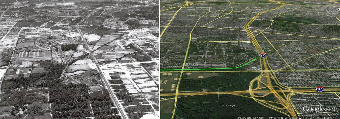
This weekend's Mystery Foto was another spectacular aerial of the Motor Parkway.
Mystery Foto questions:
- Identify the location
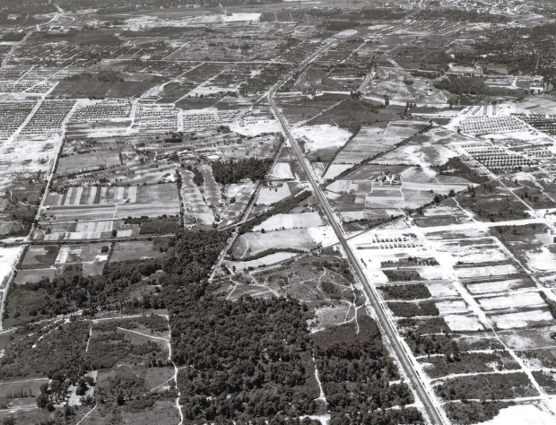
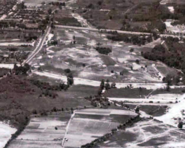
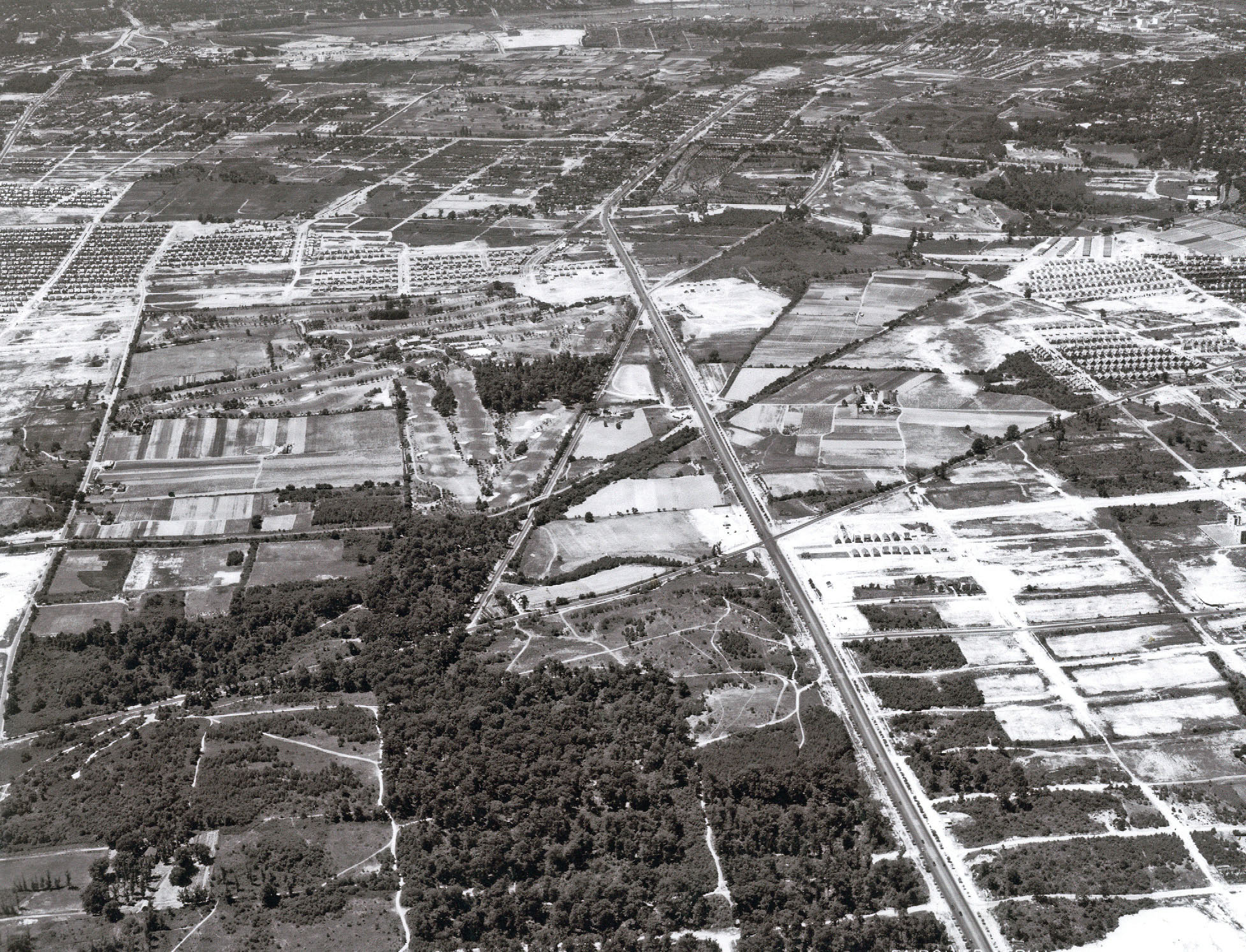
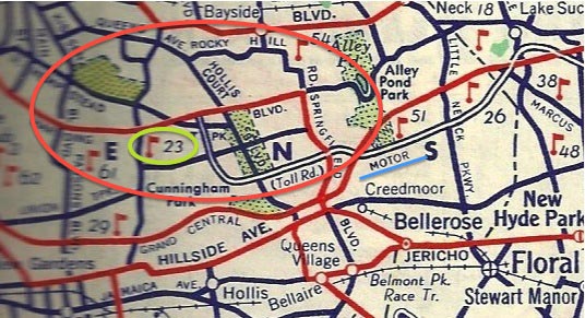
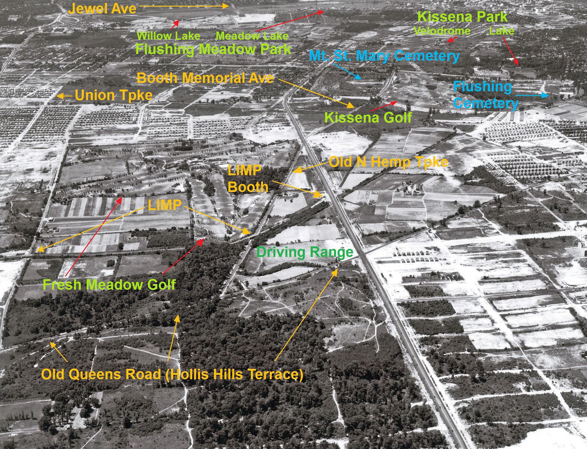
View is looking west in Fresh Meadows at the Western Terminus of the Long Island Motor Parkway.
- Identify the Motor Parkway structures
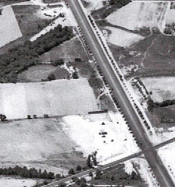
Motor Parkway Bridges: North Hempstead Turnpike (right) and 73rd Avenue (left)
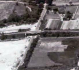
Toll Collection Structure: Nassau Boulevard Lodge
- Identify the other major roads
Long Island Motor Parkway- Across the middle of the aerial (left to right)
Nassau Boulevard (Horace Harding Boulevard)- Large road (top to bottom)
North Hempstead Turnpike- To the left of Horace Harding Boulevard
Black Stump Road (73rd Avenue)- Top to bottom on the left
Queens Road (Later Hollis Hills Terrace)- Below the Motor Parkway
Francis Lewis Boulevard AKA as Cross Island Boulevard (Under Construction)- Below the Queens Road on the right
- Identify the sports-related areas
Fresh Meadows Country Club- Above the Motor Parkway adjacent to the North Hempstead Turnpike
Fresh Meadows Golf Driving Range- Above Queens Road and left of Nassau Boulevard
Kissena Golf Club- Upper right hand corner
Queens Bike Path on the closed Motor Parkway
Cunningham Park
- What was the date of the aerial?
July 23, 1939
Congrats to Greg O., Tim Ivers, Steve Lucas, Art Kleiner (see Kleiner's Korner), Frank Femenias (see Femenias' Findings) and Michael LaBarbera for identifying the Western Terminus in Fresh Meadows location. Kudos to Greg O. and Frank Femenias for correctly answering every Mystery Foto question.
Enjoy,
Howard Kroplick
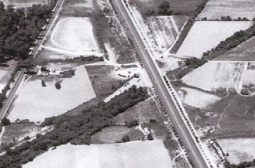
The Western Terminus of the Motor Parkway. The Nassu Boulevard Lodge (never used) is a dot in this aerial.
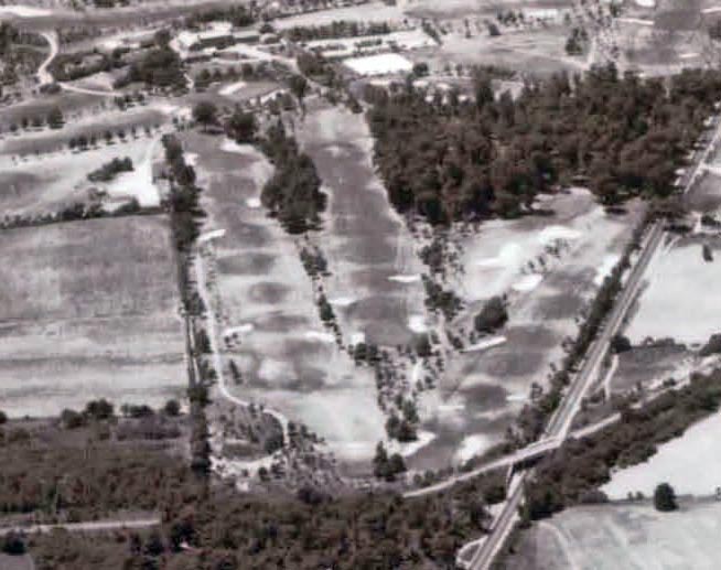
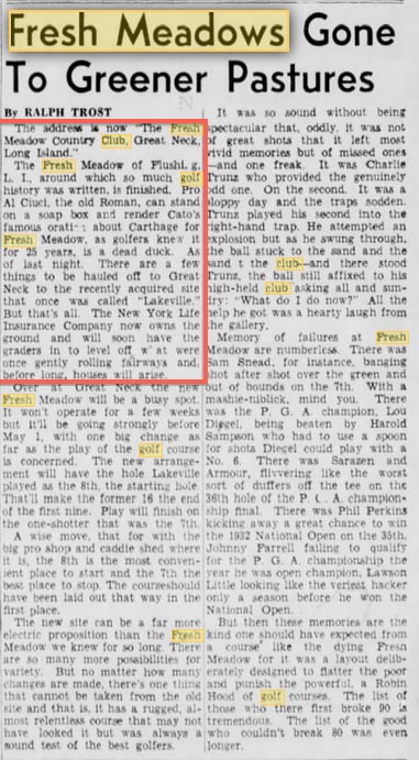
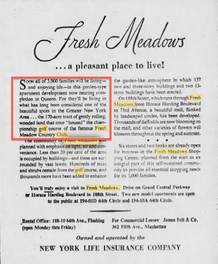
Fresh Meadows Country Club. The course was designed by A.W. Tillinghast and was the site for the 1930 PGA Championship and the 1932 U.S. Open.
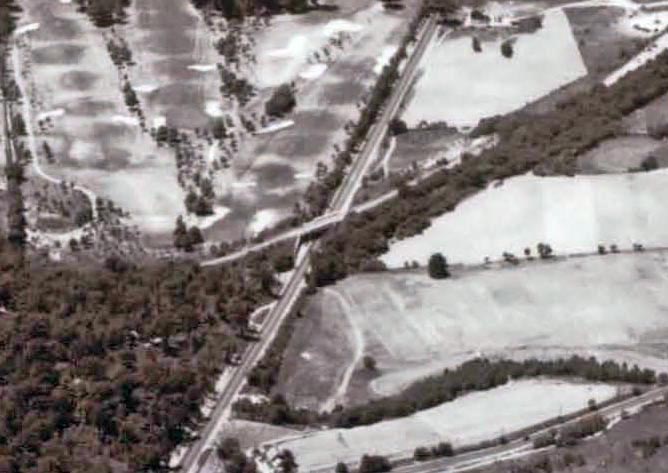
The North Hempstead Turnpike Motor Parkway Bridge
Kissena Golf Club
73rd Avenue Motor Parkway Bridge
Fresh Meadows Golf Driving Range
Kleiner's Korner (Submitted by Art Kleiner)
1936 Socony
1938 Socony
Brooklyn Daily Eagle, April 1946
Brooklyn Daily Eagle, April 1949
Brooklyn Daily Eagle, May1935
Brooklyn Daily Eagle, 1935
Femenias' Findings (Submitted by Frank Femenias)


Comments
Identify the location
-LIMP Western Terminus in Fresh Meadows
Identify the Motor Parkway structures
-The North Hempstead Turnpike Bridge, & the 73rd Avenue (Black Stump Road) bridge both built in 1926.
Identify the other major roads
Black Stump Road, North Hempstead Turnpike, Queens Road (Later Hollis Court Boulevard)
Identify the sports-related areas
Fresh Meadows Golf Driving Range, Fresh Meadows Golf Course
What was the date of the aerial?
July 23,1939
Fresh Meadows….1939
Looking west…Nassau Boulevard on right
North Hempstead Turnpike on left
Motor Parkway and bridge running diagonally across middle
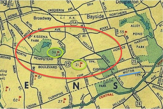
This photo appears to be looking west with the photographer flying over the northern section of Cunningham Park. The LIMP runs left to right (south to north) with its western terminus at Horace Harding Blvd., the main road running from bottom to top through the center. LIMP structures include bridges over 73rd. Avenue and North Hempstead Tpke. The toll lodge (booth) at Horace Harding Blvd. could still be there although it’s tough to tell. Other main roads in the area include Union Tpke., Hollis Court Blvd., 164th. Street, and the northern section of Francis Lewis Blvd. (under construction) although it was probably still known as Cross Island Blvd. at the time. Besides Cunningham Park, other sports areas include the first Fresh Meadows Golf Course (opened in 1923) and the Fresh Meadows Golf Driving Range. Because of similarities between this photo and mystery photo #2 from earlier this year, I think they were both taken around the same date of June 24, 1938.
Identify the location: Western Terminus of the Motor Parkway, Fresh Meadows
Identify the Motor Parkway structures: 73rd Street Bridge, North Hempstead Turnpike Bridge
Identify the other major roads: Francis Lewis Blvd., Nassau Blvd. - North Hempstead Turnpike, Horace Harding Blvd., Hollis Court Blvd., Northern Blvd.
Identify the sports-related areas: Fresh Meadows Golf Club, Fresh Meadows Driving Range, Kissena Golf Club, Cunningham Park
What was the date of the aerial? 1938
Nice aerial, most likely another Fairchild. At center of roadway spaghetti is the LIMP western terminal, Fresh Meadow, NY, looking west, July 1939, closed for autos 1 year, opened for pedestrians/speedy bicycles. I see the toll entrance kiosk at center of LIMP roadway just south of Horace Harding Blvd (L.I.Expwy), also visible is the LIMP North Hempstead Tpke parkway bridge, the 73rd Ave (Black Stump Rd) parkway bridge, Hollis Court Blvd (intact), Union Tpke section on upper left edge, Central RR (abandoned) adjacent to the kiosk. There’s Fresh Meadow golf (1932 U.S. Open) at N Hemp Tpke and 186th St, Tee-Off golf just south of Horace Harding Blvd and Hollis Court Blvd, Kissena Park golf at Booth Memorial Ave (N Hemp Tpke) and Fresh Meadow Ln, Flushing Meadow Corona Park (Valley of Ashes) boating at Meadow lake, and Holy Cow basketball yet to be.
I dont know Queens that much but it looks like Fresh Meadows Western Terminus, Hollis Terrace and Cunningham Park with the North Hempstead Turnpike Bridge. My Guess as of the year is between 1926 and 1930 before the Grand Central Parkway was built. Some roads are Union Turnpike, Springfiled Blvd and Horace Harding Blvd/Nassau Blvd but it is very hard to get my bearings as to which direction the picture faces. Good Puzzle !! Mike
I would love to see a map overlay showing the Grand Central Parkway and LIE in relation to the old photo. So much has changed its still hard to imagine the picture and how it sits in todays landscape, and I was just in Fresh Meadows on Saturday !!
http://www.historicaerials.com/
Micheal - this website allows you to search for a location (i.e., 73rd Avenue, Queens, NY) and select two years you want to overlay. Using the slide or dissolve function you can overlay the two at the same time. For this part of Queens I was able to overlay 1954 and 2013. Have fun!
Thanks Art, I used that site before, it keeps one busy for sure !!! Gonna check that one now. Mike
Still hard to tell because the picture faces west and the Historic Aerials site only allows north top south bottm orientation, but can anybody tell me if at the top right quadrant of this picture…. would that be St. Mary’s Cemetery ?
Hi Michael,
St. Marys Cemetery is correct in that quadrant, just off to the left of Booth Memorial Ave. I’m sending some late pics to clarify. Hope it helps. Cheers
Also Michael, I used Howard’s last photo of the expandable Mystery shot, then further zoomed in using simple Windows Photo Gallery software on the pc, and was amazed to see activity at Flushing Meadow’s Meadow Lake during the ‘39 World’s Fair at the top edge of the photo. These Fairchild aerials are by far the sharpest of the day. Thanks as always Howard for sharing these gems. Cheers to all.
Hi Frank I did it in picture and fax viewer and saw boats on the lake, too bad the photo didn’t capture the Trilon and Perisphere, i guess that would have been more to the right after the picture ends.
I was in Fresh Meadows again on Saturday and saw the Hollis Hills Terrace Bridge and the Springfield Avenue Bridges. I want to take my bike for a ride there, but where does the bike path actually begin since there is no more Western Terminus ? Is it 73rd Avenue or somewhere in Cunningham Park ?? Mike
Mike, the greenway bike path was extended and now mostly connects all the area parks (Alley, Cunningham, Kissena, Flushing Meadow….). But to stay closest to the LIMP, it starts off the RoW at the bottom of the LIE pedestrian overpass (also part of the greenway path) hidden behind the school at LIE and Peck Ave, then winds around through Holy Cow Playground back towards Peck Ave (where the N Hemp Tpke bridge used to be located). There you’ll find the existing LIMP RoW next to the sidewalk. Brace yourself for a hilly, heavy downshifting adventure. Willie K made some of them pretty steep and choppy! Follow the path and have fun!
Thanks Frank its good to know, im looking for some bicycle adventures and that area is so nice. The first time i was there was in November at a funeral at St. Marys Cemetery….little did i know of the history surrounding it. Last week i went to the Springfield Avenue Bridge (where the 2 ladies in the old mystery photo stood against the abuttment). Going up the ramp led to some beautiful terrain, and i can’t wait to explore it more.
One other question i have is that there is an old picture on the VCR website… near the terminus of an old car flying by a signpost with many different arrows pointing to everywhere, and it looks like in the very foreground of the picture there is a gravestone or a road marker. Is that corner still there today ? Mike
Hi Frank, This Picture is the one im curious about….what is that stone marker ? Mike
http://www.vanderbiltcupraces.com/blog/article/from_the_nyc_municipal_archives_images_from_the_motor_parkway_and_the_1937_
Hi Michael! That corner is still there. It’s where Cedar Grove Cemetery is located on Horace Harding Expwy and about 350ft east of College Pt. Blvd. It used to intersect with Rodman Street (still existing) there but the L.I.E. changed all that. Heavy traffic there then, and still today! I believe the white sign below the Motor Pkwy sign on the post says Cedar Grove Cemetery. This is 3mi. west of the LIMP terminus. Those cars are indeed speeding, and they’re on the future L.I.E., heading east towards the terminus. The gravestone may have been used as an entrance post for the cemetery once but removed., After using Google street view, I was unable to locate it but it may still be there requiring a visit for a closer look. I doubt it’s there though because it looks too old and out of date to be used as an entrance post, if that’s what it was. But looking at that roadway, I cant decide which I’d prefer, dirt or potholes. Lol. Keep on ridin’
Howard, I think Michael’s photo in question may make a great mystery!
Hi Frank and Howard, I totally agree, and in going to the cemetery’s site they provide an immediate street view, so I “cruised” east of the entrance…...and low and behold, there’s the Monument Store !!! My guess is that the HH road was very close to the graveyard (probably the service road). Over time, ramps went up, houses were demolished and it must have been an earth moving extravaganza - and we all can agree that the LIE is north of the service road looking east - however, we do have a gravestone right next to the road in that old picture, with no ramps or LIE yet, but the cemetery was there since the 1890s, and im guessing, so was the monument store. However, with an earth moving ordeal going on all around during the construction of the LIE and ramps, it was possibly a grave that had to be relocated, or it could be a gravestone not yet sold from the monument store…....definitely a great mystery. I’ll bet that someone at the cemetery office has an old diagram in their records. Mike
Mike, you’re dead on with the gravestone! Lol. We share the same possibilities. Though, after reconsidering its height (approx 7-8ft.), It’s most likely not a cemetery entrance post (those would be much larger and grand), but most likely a monument for sale by same vendor on Horace Harding Blvd (Nassau Blvd). Another possibility is that the stone was purchased close to the date of the photograph (1931), and most likely installed somewhere in Cedar Grove or Mount Hebron (too expensive to transport to another cemetery). Not sure. Also, I have strong suspicion we crossed paths that same day by the lake in FM Park. Contact me. .(JavaScript must be enabled to view this email address)
Will do Frank, but it wasnt me at FM park though, I was in Cunningham Park and Alley Pond Park that day exploring the Hollis Tereace and Sprigfield Blvd. bridges.
Howard, good to meet you at Kings Point yesterday it was fun watching the Black Beast roar and spit fire, my daughter jumped back when it started up!! Great restoration on the Imperial and Lots of Luck with the “Shorty” Mustang too, Mike