Mystery Foto #53 Solved: Clinton Road, the Motor Parkway in Garden City and Curtiss Field Circa 1926
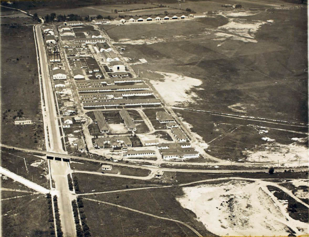
Milan G. Sharik, Jr. submitted this week's Mystery Foto...Another classic Long Island aerial.
Answers to the Mystery Foto Questions:
Identify the location of this aerial.
Looking north in Garden City. Clinton Road is on the left. The Motor Parkway can be seen diagonally going east/west.
Identify the structures in the aerial.
The Clinton Road Motor Parkway Bridge, the original Motor Parkway's General Manager's office and the Garden City Lodge.
Further north, the buildings and hangars of Curtiss Field before it became part of Roosevelt Field.
What is the approximate date of his aerial? Explain your reasoning.
The aerial was taken around 1926 before the Intercollegiate Golf Club (later Old Westbury Club) was built in the southern section of the field. Moreover, According to my favorite co-author Al Veloccci, the porte cochere (portico) for the Garden City Lodge was not built until 1929. The original General Manager's office was also replaced in 1929.
Congrats to Joe Osterle, Lee, Tim Ivers, Steve Lucas, Greg O., Michael Appice, Frank Femenias and Bob Miller for identifying the Garden City location. Kudos to Lee, Steve Lucas, Michael Appice, Art Kleiner and Greg O for their guesses of the aerial's date.
Thanks to Frank and Art Kleiner for the additional documentation.
Enjoy,
Howard Kroplick


Comments
Joe Oesterle 1:27 AM
LIMP, Clinton Ave, Roosevelt Field.
Structures include LIMP Bridge over Clinton, Garden City Toll Lodge, Managers House, along with buildings and hangers for the airfield.
I can only guess the year. Prior to 1938. My guess is the parkway is still open during this picture. -joe
__________________________________________________________
Lee 10:46 AM
Roosevelt Field Airport
Glen Cove Rd (On left) heading north
Vanderbilt Parkway Bridge and Toll Crossing over Glen Cove Road
Old Country Road East-West (Top of Picture)
Earlier than 1920 (guess)
_______________________________________________________________
Tim Ivers 11:52 AM
Clinton Road bridge, Garden City, looking north.
Curtiss Field at top right.
Garden City toll lodge and parkway manager’s office buildings at bottom
below parkway to right of Clinton Road. Bridge was one of a few built
with 3 lanes under it.
About 1930.
____________________________________________________________________
steve lucas 10:41 PM
This photo sure looks like East Garden City looking north with the LIMP going west to east in the foreground and the bridge going over Clinton Road. The confusing part is trying to establish the date. The Garden City lodge looks like it is still under construction (no porte-cochere built yet) so that would make it 1911. But the general manager’s office is there and that wasn’t built until 1915. Also, I believe the large complex north of the LIMP is the Curtiss Aeroplane & Motor Co. but I thought that was built a little later. All very confusing.
____________________________________________________________________
Edith 6:58 AM
Mitchell Field
_________________________________________________________________________
Greg O. 10:15 AM
I actually have this exact photo in my collection from looking for answers to the very similar picture/vantage point of mystery photo #2 last year.
Looking North, it’s Hazelhurst/Curtiss/Roosevelt Field alongside of Clinton Ave. The Clinton Ave bridge, Garden City lodge, and LIMP office are seen South of the field. Mystery photo #2 was 1927. In this photo, there is to be more hangar development, but still no runway. Since it appears to be the first LIMP office, my guess for this photo has always been 1929 and the office was rebuilt/replaced shortly thereafter.
_____________________________________________________________________________
Michael Appice 4:08 PM
This weeks photo is Roosevelt Feild. The hangers are at the top of the photo and the various shops are in the left of the photo The left side bottom of the photo is the Glen Cove Rd. Motor Parkway bridge with the toll house to the right of the bridge. Since theres a grass field and it looks like a Model T in front of the building i think the photos date is around 1920
_________________________________________________________________________
Ted 3:03 AM
Here’s another mystery that I can’t figure out, but only can guess at. Looking through the photos I found some possible areas it could be which is Roosevelt Raceway, Rock Hill Toll Lodge, Fresh Meadows and Commonwealth Blvd all in the late 1920s to the early 1950s. Can’t tell you exact detals
Feb 03 2014 Bob Miller 12:14 PM
That’s the curve over clinton road, Garden City. That was the only 3 support highway bridge I know about. The office and Toll Lodges are also in the photo.
Looks Great.
____________________________________________________________________________
Bob Miller 12:16 PM
Correction on my comment. It had 2 supports and 3 bays over the roadway. Sorry about that. Don’t know the date, but it does look ca WW I to me.
__________________________________________________________________
From Rich Carlsen:
“Can the mystery photo be that of Mitchell Field?”
Feb 03 2014 Howard Kroplick 7:55 PM
_____________________________________________________________________
From Jon Shapiro
“Farmingdale, NY, Republic Aircraft Corporation - 1941”
____________________________________________________________________
From Art Kleiner:
“The date of the photo is stressing me out more than it should. Office might be the original which will throw my original reasoning out the window.
Location - Roosevelt Field, Garden City (Old Country Road, Clinton Road, LI Motor Parkway)
Structures - Motor Parkway Clinton Road Bridge, Garden City Lodge and Office, hangers, barracks, water tower.
Date - either early 1940s (new barracks and water tower) or pre-1929 (original office)?
Attached is the 1940 census roll showing the occupants of the lodge (239 Clinton Rd) the Ernst family (value listed is $3,300) and the office (241 Clinton Rd, value of $9,000) occupied by the Whitten family. Ernst is shown as a carpenter and Whitten has something to do with aeronautics.
Also attached is the property description for the office indicating it was built in 1929 and remodeled in 1939 and a 1946 Newsday article about an intruder.
Interesting again this week.”
______________________________________________________________________________
Frank 12:11 AM
Does anyone know what the lone structure is on the west side of Clinton Road (north of the bridge) in the 1926 photo?
This photo shows another historic feature that has never been called out before, at least to my knowledge.
In it is the hanger where Lindbergh’s Spirit of St. Louis was kept in the days before his historic flight.
But…what remains unclear to me is which building in the photo is actually the one?
Nothing in this general photo specifically identifies it.
But in close-up photos taken of the airplane in those days before May 20th, the hanger building is in the background. There are distinct wood-frame supports for the hanger doors that rolled horizontally back to allow an aircraft to enter or leave.
The challenge is matching the close up with the building located near the “back” of this photo, closer to Old Country Road than to wherever the photographer was located when the photo was taken.
I am fairly certain that Lindbergh’s hanger was immediately adjacent and to the east of Clinton Avenue, within 100 yards to the south of Old Country Road. And that the roll-away doors of the hanger faced to the south. But without the ability to enlarge this photo I cannot confirm this.
Can anyone lend a hand?
The spot merits a historical marker.
I was a Garden City police officer 1956-1966. The old timers on the force talked about the horrific head on crashes in the middle lane under the bridge before it was torn down.