Kleiner’s Kolumn: The Long Island Motor Parkway in Maps (Part II)
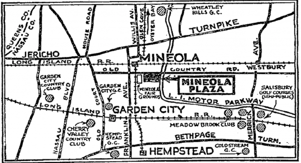
Part II of my map series displays maps that were used for what I call specific purposes and generally not for touring. For example, the accompanying map produced in 1926 and which appeared in The New York Times highlights Mineola Plaza and might have been used to promote the many golf clubs also shown.
Art Kleiner
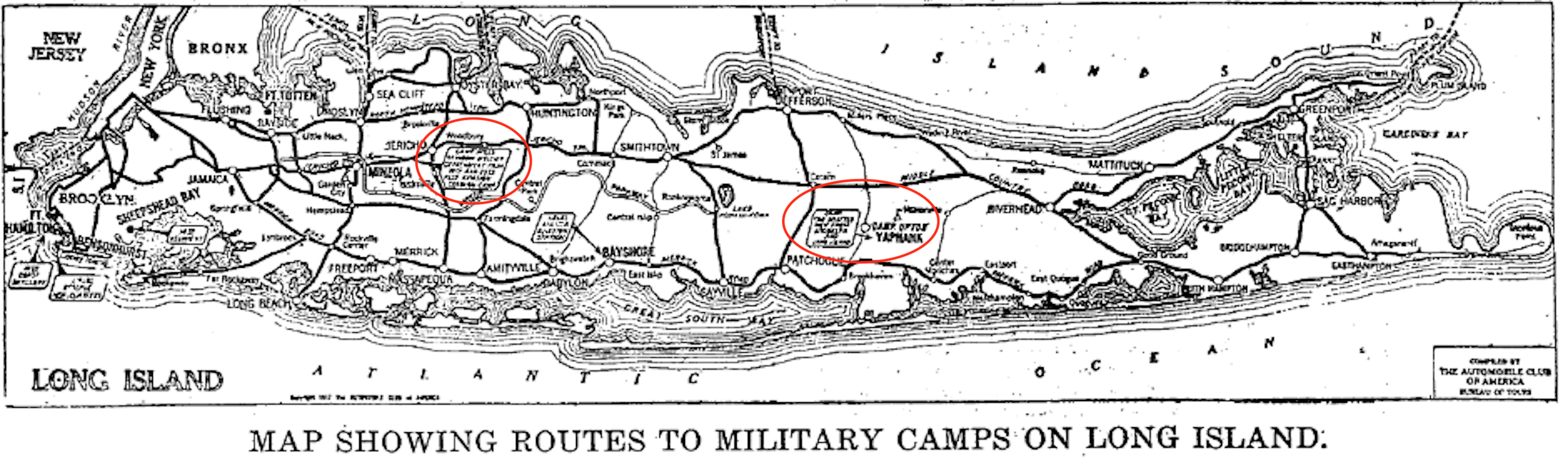
1917 map compiled by the The Automobile Club of America indicating routes to military camps on LI. From what I can make out I see Camp Mills and Camp Upton.
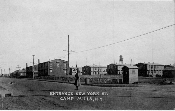
Camp Mills, 1918 (Courtesy New York Heritage digital collection)
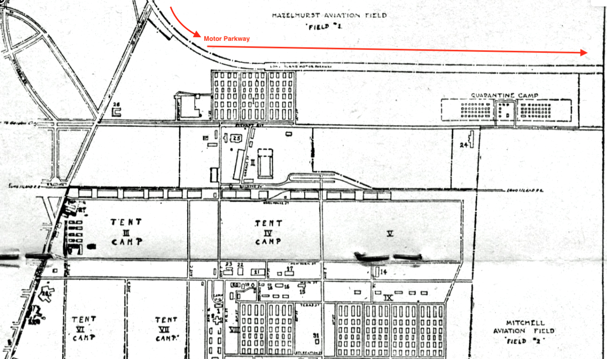
Camp Mills and Mitchel Field, 1918 (Courtesy of Bill Bellmer)
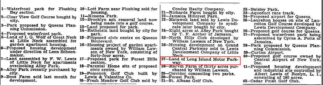
Big plans for this area in Queens as noted in this Brooklyn Daily Eagle map of Nov., 1925. Had some strong backers but the plans didn't seem to materialize.
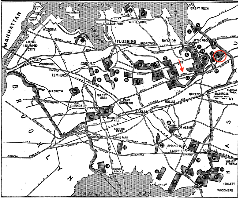
Interesting map from 1931 published in The New York Times showing land purchases, who purchased the land and intended purposes. Motor Parkway property noted as #27. The next picture provides details for each location.
Golf courses, parks, housing developments, airports. Feel free to comment on those of which you are familiar.
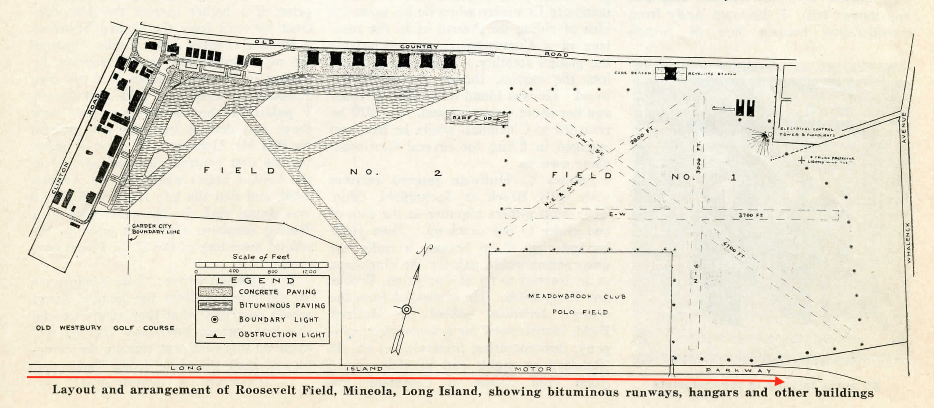
1932 Roosevelt Field
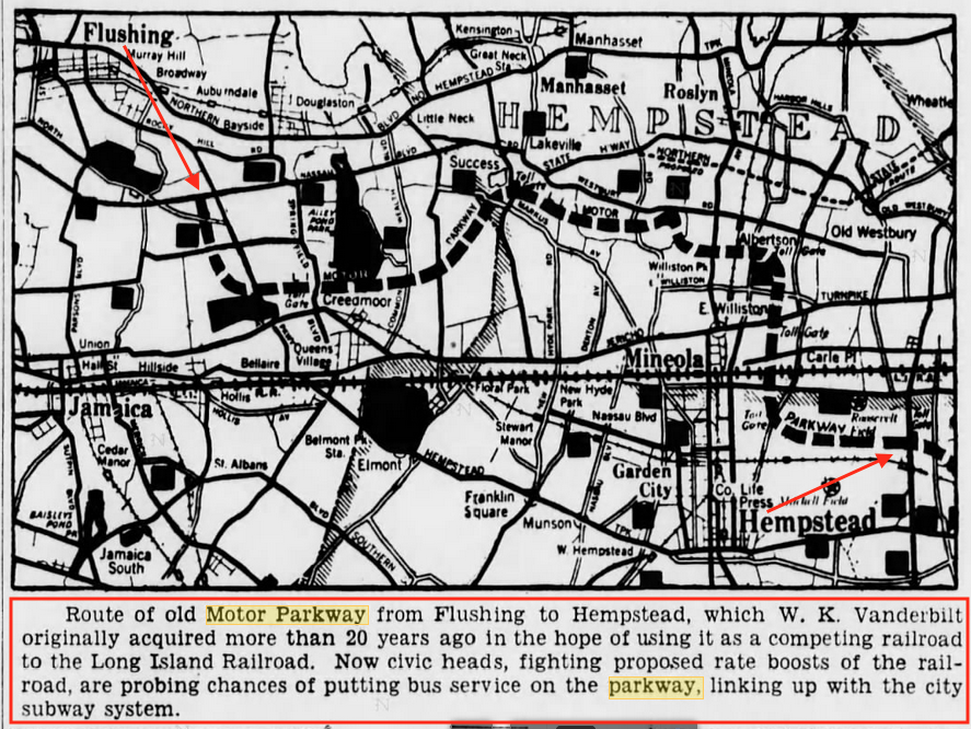
In 1935 LIRR commuters were upset with increasing fares (does anything ever change?) and looked at using the Motor Parkway as a bus route. This like the previous noted Hollywood, Queens never materialized. Opening sentence also misstates why Willie K. purchased the land for the Parkway. (Brooklyn Daily Eagle)
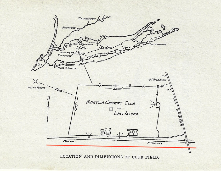
From the 1940 Long Island Aviation Country Club membership book.
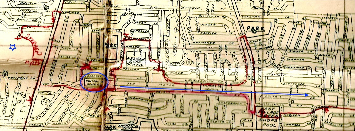
I purchased this Meenan Oil map with the red outlines already in place. Shows the Pintail Elementary School in Levittown which was featured in a recent msytery photo along with other schools on or nearby the Motor Parkway. The blue star is approximately my house built in 1954 so I'm dating this map to be circa 1951.
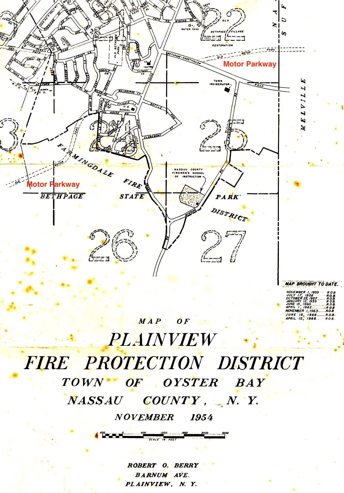
1954 Plainview FD map showing the Motor Parkway disappearing out of Bethpage State Park and reappearing on the southern border of Old Bethpage Village Restoration.
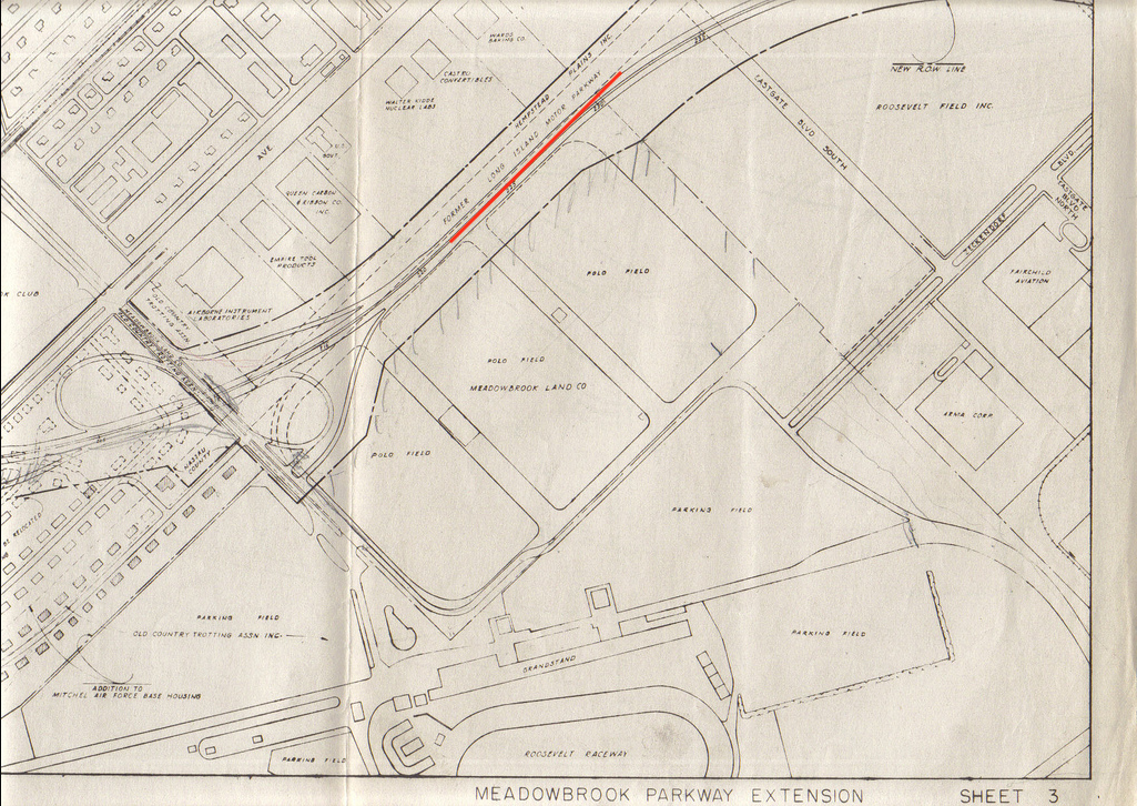
Roosevelt Field showing polo fields, Roosevelt Raceway, Mitchel Field AF Base housing and various businesses. Approximate date: early 1950s?


Comments
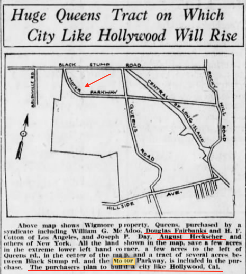
The “Hollywood in Queens” map fascinates me, not only because Queens never got its Hollywood, but also because almost none of the streets on the map bear their current names. From looking at a modern map, it looks like the roads are now named as follows: Black Stump Road = 73rd Avenue, Queens Road = Springfield Boulevard, Rocky Hill Road = who knows? The Central Rail Road is the old Creedmoor branch.
Al, Art - Amazing map how only Hillside Ave retained its name. Rocky Hill Road alone took on several names as it snaked through Flushing including; Flushing Ave (Braddock Ave), Springfield Blvd, 56th Ave, Luke Pl, 216th St, 48th Ave, and 47th Ave. Only a tiny portion of the Rocky Hill Rd name (1000ft) remains today in Auburndale, Queens. Let’s just call it RHR! :D
Here’s a resource I’ve used to map (no pun intended) old to new street names. I can’t vouch for its accuracy but a start.
https://stevemorse.org/census/changes/QueensChanges0.htm
Here’s what it says for Rocky Hill Road:
ROCKY HILL ROAD 47th AVE BAYSIDE
ROCKY HILL ROAD 48th AVE BAYSIDE
ROCKY HILL ROAD BRADDOCK AVE QUEENS VILLAGE
ROCKY HILL ROAD WINCHESTER BLVD QUEENS VILLAGE
If RHR became Springfield Blvd., then Queens Road must have become something else, possibly Bell Blvd. I can’t find any evidence that a “Queens Road” existed in that part of the borough. Today, Bell Blvd. almost meets Hillside, but not quite.
Liking your last map, Art - Meadowbrook Extension. Very obvious that today’s Merchants Concourse follows the past 2 roadways that used the twin bridges over the LIMP ( cloverleaf ). Is this map larger than is seen here? If so, it would be neat to view it.
Art - the old/new street name reference confirms some research that I did since my last post: Queens Road did not become Bell Blvd., but, rather, Hollis Court Blvd. This street now has several disconnected pieces due to construction of the Clearview Expressway.
This website, the source of my research, is a fascinating journey back in time through all five boroughs:
https://forgotten-ny.com/
Al, here’s a link to the LIMP interactive map showing the old Queens’ streets in light blue. The old street names are revealed by clicking on the road.
https://www.google.com/maps/d/viewer?mid=1396j0_672hYkvbcNFJInbc1mXNJspD9f&ll=40.742491469161216,-73.75760775553289&z=14
#20 (Fresh Meadows GC) became the site of Fresh Meadows after the War, which is where I grew up (on the other side of Horace Harding Blvd). #18 (former reformatory school) became the site of Queens College in 1937, from which I graduated (when there was no tuition). #19 (Pomonock GC) became Pomonock apartment complex. #23 became Alley Pond Park and surrounding garden apts and houses, with a right of way taken for the the Cross Island Parkway. #33 became the Aqueduct Race Track. #s 12 (the Ash dump) and 16, 17 became the site of the 39-40 and 64-65 World Fairs, which after 65 became Flushing Meadows Park, #3 became portions of the Grand Central Pkwy right of way and a part of what became LaGuardia, #30 (Forest Park) was used for the right of way for the Interboro Pkwy (now Jackie Robinson Pkwy), #13 - the southerly portion became LeFrak City (1959-60), #10, 11 became postwar housing in Fresh Meadows, north of Horace Harding, the site for Francis Lewis HS (from which I graduated), Kissena Golf Course (public) and Kissena Park [I could go on but I’m getting dizzy going back and forth between the map and these comments]
What is where the polo fields were now? I thought that they were under the Meadowbrook parkway, but this map seems to say otherwise.
Great stuff Roy, and I still call them the Interboro, Triborough, and Queensboro! Can’t teach this old dog new tricks.
Adding to Frank’s comment.
The stretch of 46th Ave that forms the northern border of Flushing Cemetery once had a dual identity as Queens Avenue and Rocky Hill Road. From Queens Avenue, Queens Road branched off near where 46th Ave becomes Hollis Court Blvd today.
That dual identity causes confusion in some sources. Bell Ave (Blvd) originally terminated at RHR, a much older road.
About Hollywood, Queens.
All were strong backers! Day was a realtor famous for buying and selling much of the outer boroughs through land sales and auctions. A a former Treasury Secretary under Wilson, Senator William Gibbs McAdoo (CA) was deadlocked with Governor Al Smith during the 1924 Democratic Convention and had earlier helped Fairbanks organize United Artists. McAdoo was also a land speculator here and in Florida while he served as senator!
“H.F.Cotton” is likely H.F. Reindel, attorney for the Cotton & Franklin law firm (previously McAdoo, Cotton & Franklin). Cahill Gordon & Reindel (same Reindel) is the direct successor of McAdoo’s firm and the Joseph P. Day Realty Corporation still exists.
1918 Camp Mills photo attributed to me is actually from the New York Heritage digital collection:
https://cdm16694.contentdm.oclc.org/digital/collection/p16373coll49/id/1797/rec/36
Brian, thanks. I’m still trying to figure out where I got that last map from. So far no luck!
Brian, Your mention of the twin bridges/ Merchants Concourse prompts me to share some info I recently uncovered regarding the Parkway bridge at that location. The Parkway was obligated to build three north-south bridges bridges between Clinton Rd. and Merrick Ave. for the Stewart heirs. Howard and I always assumed that bridge was one of them and wondered why there and then in 1908 as there wasn’t any activity in the area. Well, it wasn’t one of the three. That bridge was built over a lightly used Hempstead Town highway called Sheep Pens Rd. that at one time ran from Merrick Rd. near Old Country Rd. diagonally down to Hempstead Village. North of the Meadowbrook it is completely gone. The section of that road between the Meadowbrook Parkway and Stewart Ave. would be called Ave. C before it became Merchants Concourse. South of Stewart Ave. Sheep Penns Rd. disappeared thru Mitchel Field. It reappears again on the west side of Oak St., called Westbury Rd. The bridge built by the Meadow Brook Club came down in 1944, working on when the demo of the Parkway bridge took place.
Yes Al, I noticed a Sheep Rd on the 1938 map that Art obtained from Nassau County. It’s shown as heading SW/ diagonally from the LIMP. Map also shows what looks to be the Hempstead Spur that didn’t come to be? I copied a 1914 map you’ll see below that shows Sheep Pens/Westbury Rd on both sides of the LIMP & also shows roads where HWY bridges were planned, but not built. I marked the Station # of the planned bridges ( #331 was Roosevelt Field ) Think I have it right? Realize too that these older roads were scrubbed out due to the military camps.
Brian, The 50 foot wide spur to Hempstead Tpke. was never built. The cost was too prohibitive. The Parkway would have had to build a bridge over Stewart Ave., the Central Railroad , Sheep Pens Rd., and, if ever developed that far, Second St. (Meadow St.) which did make it to Oak St. The spur was never in play until July 1, 1918 when the Parkway leased the strip to the federal govt. for $31.99 per month. In 1939 the govt. purchased the spur for $8900.
David Stephan - In regards to RHR following Queens Ave/46 Ave, was RHR’s western terminus at Parsons Blvd? This is interesting news.
Timothy - The above map is upside down, with south up. The Meadowbrook Pkwy now runs along the southern section of the old polo fields. Just to the north of MSP is now mostly occupied by Meadowbrook Pointe condos.
Queens Rd. became Hollis Court Blvd., which ran from the LIE to 46th/47th Ave. The Q26 ran on it, which I routinely used to go the the IRT in Flushing. It started across the Street from what became Penn Fruit (I think it became a Waldbaum’s). We moved to the neigborhood in 1953. Nothing was there. Penn Fruit came in in 1958. The Blue Bay Diner, a few years after that.