Femenias’ Findings: Anatomy of an Amazing 1938 Aerial (Garden City to East Meadow)

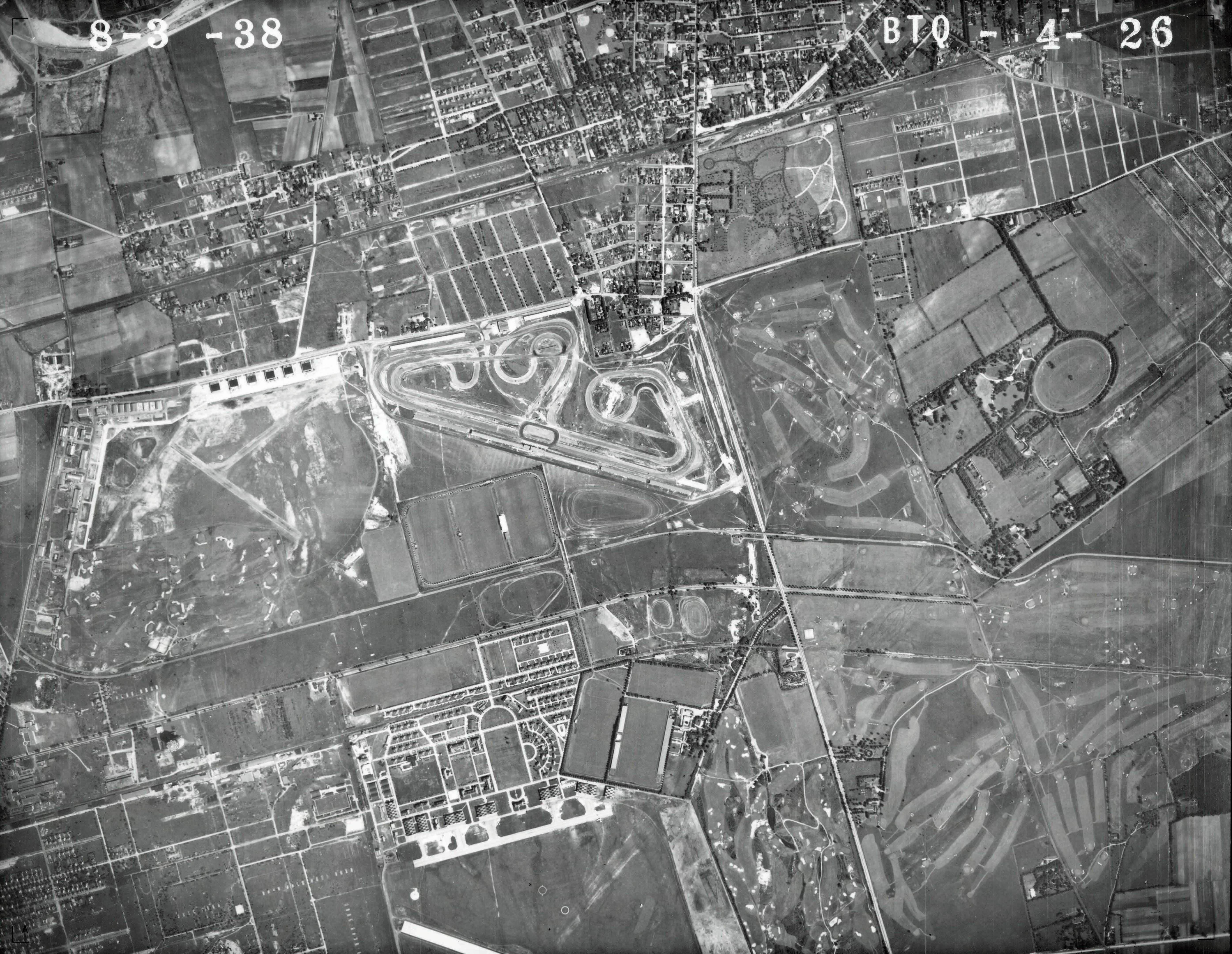
My favorite Nassau County aerial from the U.S. Department of Agriculture 1938 series highlighted the area from Garden City to East Meadow.
Here are some of the historic locations captured in the aerial:
- Roosevelt Field
- Mitchel Field
- Roosevelt Raceway
- Meadow Brook Polo Fields (north and south of Stewart Avenue)
- Salisbury Links and Meadow Brook Golf Club
- The Long Island Motor Parkway (sections used for the 1908, 1909 and 1910 Vanderbilt Cup Races)
- Public roads used for the Vanderbilt Cup Races; Old County Road (1909 & 1908), Ellison Road (1908) and Hempstead Turnpike (1904)
- Central Railroad of Long Island
VanderbiltCupRaces.com favorite mapper Frank Femenias has provided these wonderful "Then & Now" comparisons of these locations with current aerials available from Google.
Enjoy,
Howard Kroplick
Femenias' Findings (Submitted by Frank Femenias)
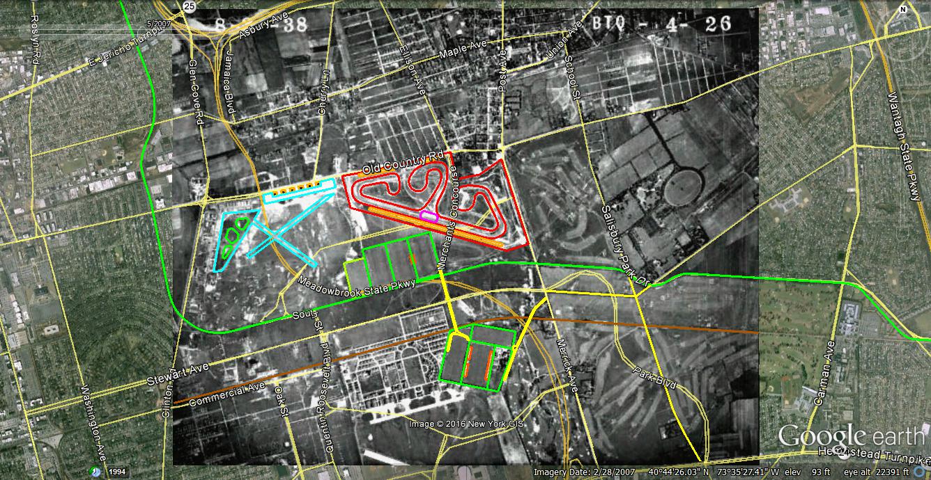
Key:
Long Island Motor Parkway (green line)
Central Branch of Long Island (brown line)
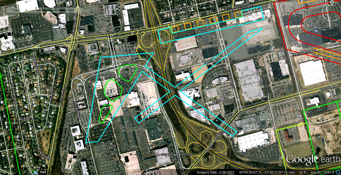
The runways and hangars of Roosevelt Field
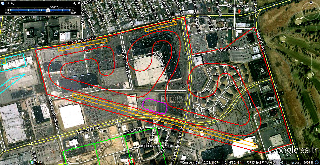
Roosevelt Raceway
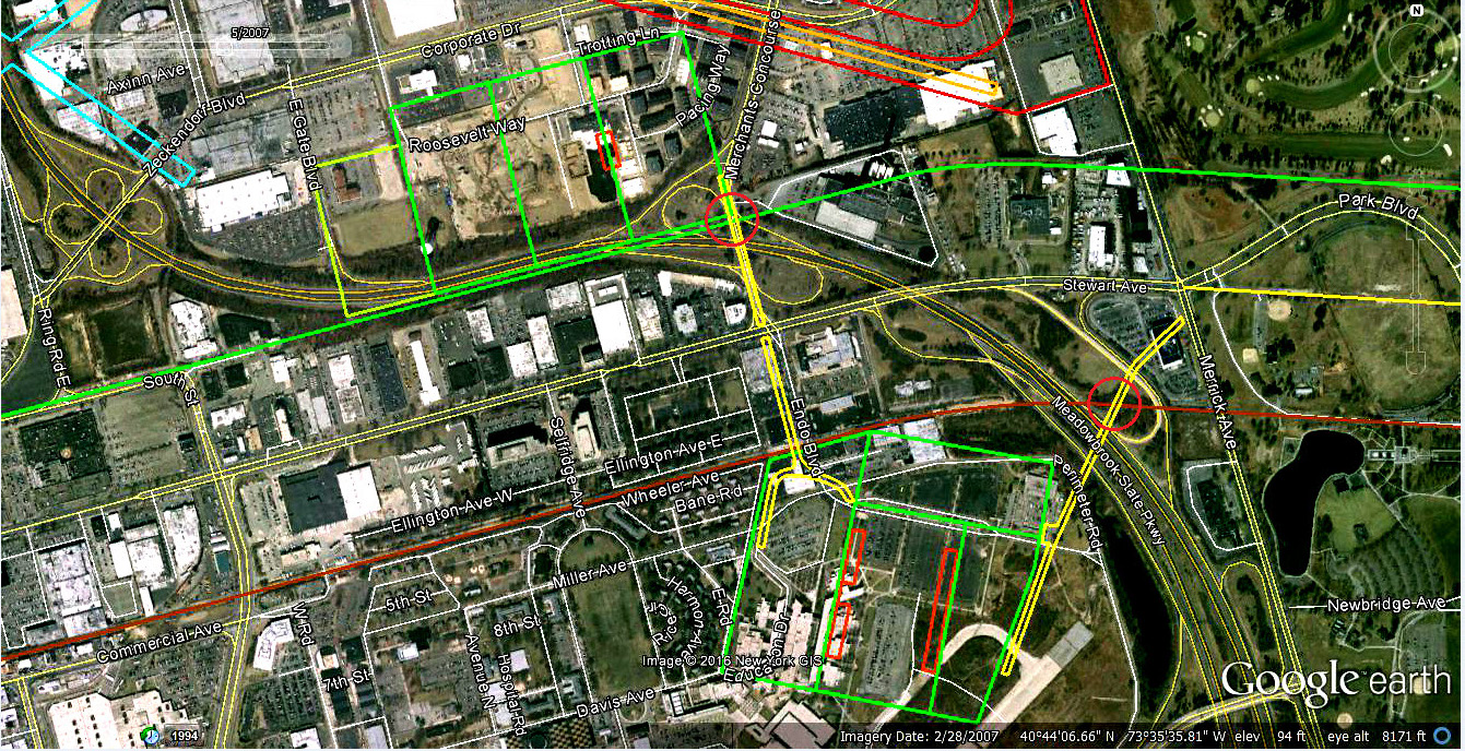
The fields of the Meadow Brook Polo Club. Note: the north polo field became the grandstand and parking lot for the new Roosevelt Raceway built for harness racing. The north polo field was closed in 1954 as New York State took over a section of the field for the Meadowbrook Parkway.
The location of the Roosevelt Field Motor Parkway Bridge- on Merchants Concourse north of the Meadowbrook Parkway and south of the Covanta plant entrance.
The entrance to the Meadow Brook Polo Club from Merrick Avenue with the road going under a Central Railroad bridge. The Central RR is marked by a red line.
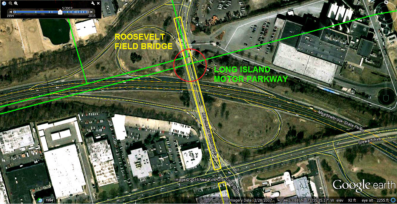
Closeup: The location of the Roosevelt Field Motor Parkway Bridge. Note: A small section of the Long Island Motor Parkway right-of-way crossed the Meadowbrook Parkway.
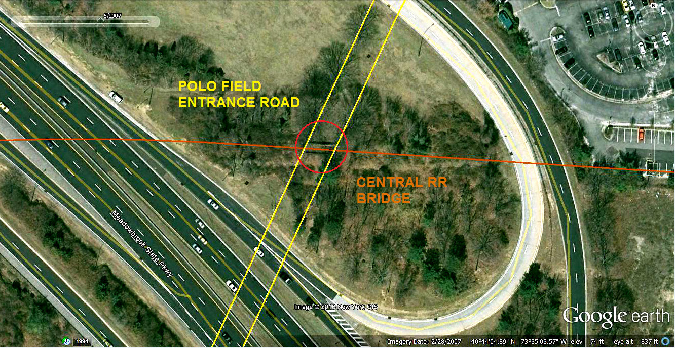
Closeup: The entrance road to the Meadow brook Polo Club. Note: The Central RR Bridge is still standing!
Click to enlarge.


Comments
Re Feminas’ Findings: What a nice presentation! Thanks.
This clears up my mistake about exactly where the “twin bridges” we’re located. I initially thought the Roosevelt Field and Meadowbrook Club bridges were closer to today’s Quentin Roosevelt Blvd ( I mentioned that on the 8/22/16 blog, Mystery photo #34. It would’ve been ideal if the 1956 aerial displayed more easterly to Merrick Ave. The remnants of these twin bridges might of still existed. I saw the 2 roads running north from Stewart Ave to the LIMP on a 1947 topo.) I’ve said this before, Frank….Howard is fortunate to have your expertise and genuine interest in the making of your maps, etc.
Great post Frank. Cartography and topography are your gifts. I love how you show the old and new. Thank you.
More in the Central RR bridge at:
http://sbiii.com/lirrcrr1.html#crrbridg
and:
http://sbiii.com/lirrcrr3.html#crrbridg
The thumbnails are really bad (gotta redo them) but they bring up good pix.
Sam, III
I lived across from Roosevelt Raceway . Roosevelt Field hangers were still there when I was a kid .one became Murray the K ‘s disco which we explored all the time were Levitz furniture is today .Joe Cranes parachute company moved out of Roosevelt Field to Old Country Rd.He sold miniature toy parachute to us kids.The hangers by my house were torn down and became Fortunoffs. We roamed the fields along the Meadowbrook Parkway playing under that Central Ave Bridge till they filled it in. We use to sneak in Mitchel Field all the time getting chased out by the guards.
Thanks to all for the nice comments, I can’t help it, I’m a before-and-after fan myself!
Brian – Howard’s 1931 arieal shows the twin bridges intact. Howard sending attachments. I tried overlaying this same aerial as well but was unsuccessful in accuracy. It’s still great for viewing.
Sam III – Nice link to the CRR Bridge. I started reading and could not put it down. The photos were great including Mr J.J. Conroy’s addition. Fantastic presentation and photos! Please keep it up