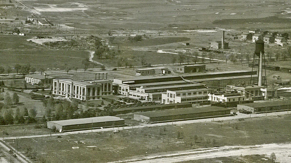
Mystery Foto #32 Solved: Curtiss Engineering Corporation Garden City Complex Circa 1925
Author Richard Panchyk challenged you once again with another classic aerial.
Mystery Foto Questions:
- Identify the location and orientation of the photgrapher
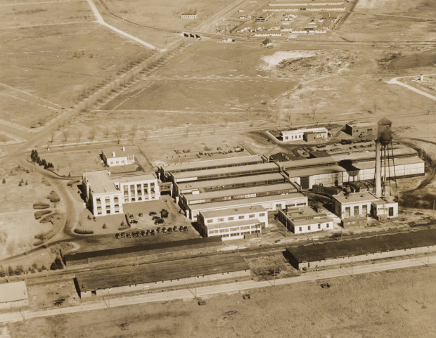
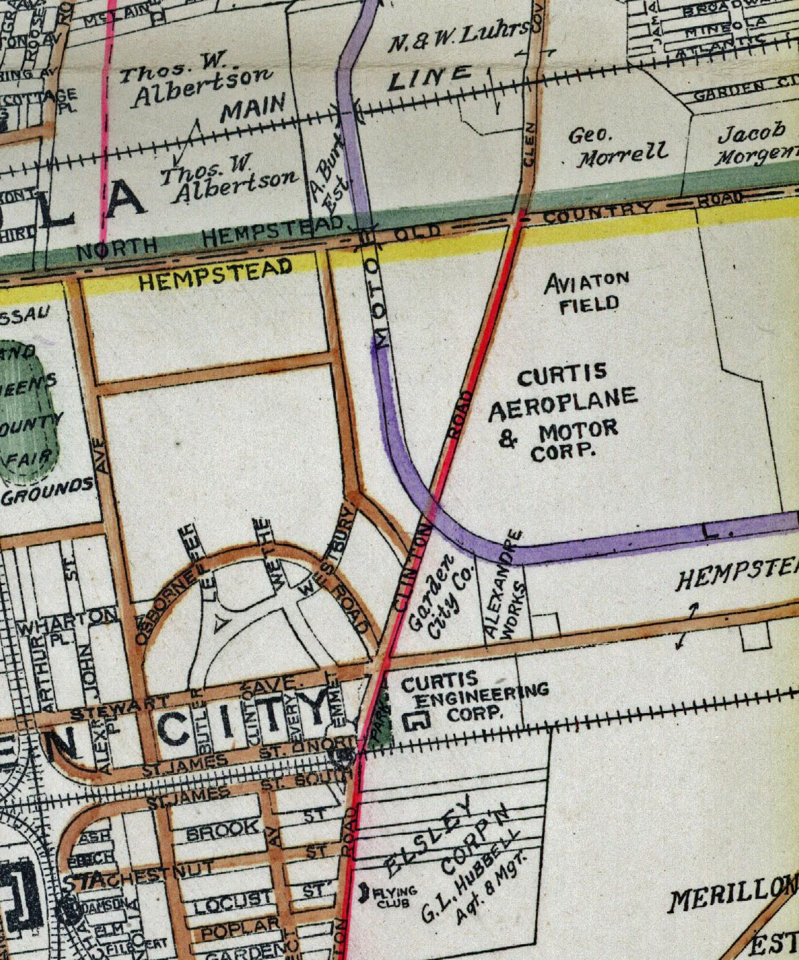
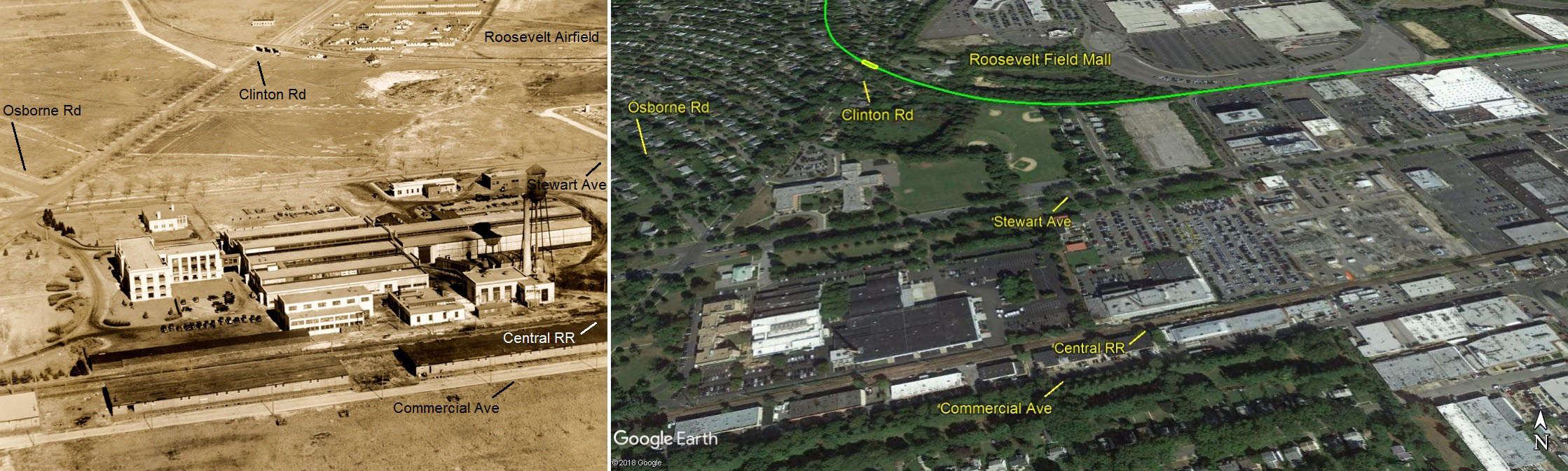
Garden City, looking north
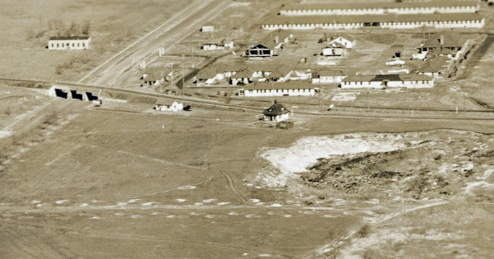
- Identify the Motor Parkway structures and major roads
Clinton Road Motor Parkway Bridge, General Manager's Office and Garden City Lodge.
Major roads: Commercial Avenue, Stewart Avenue, Osborne Road, Clinton Road and Long Island Motor Parkway
Railroad: Central RR
- What are the buildings located in the top of the aerial?
Several of the barracks and the mess hall of Hazelhurt Field with new buildings for Curtis Field being built.
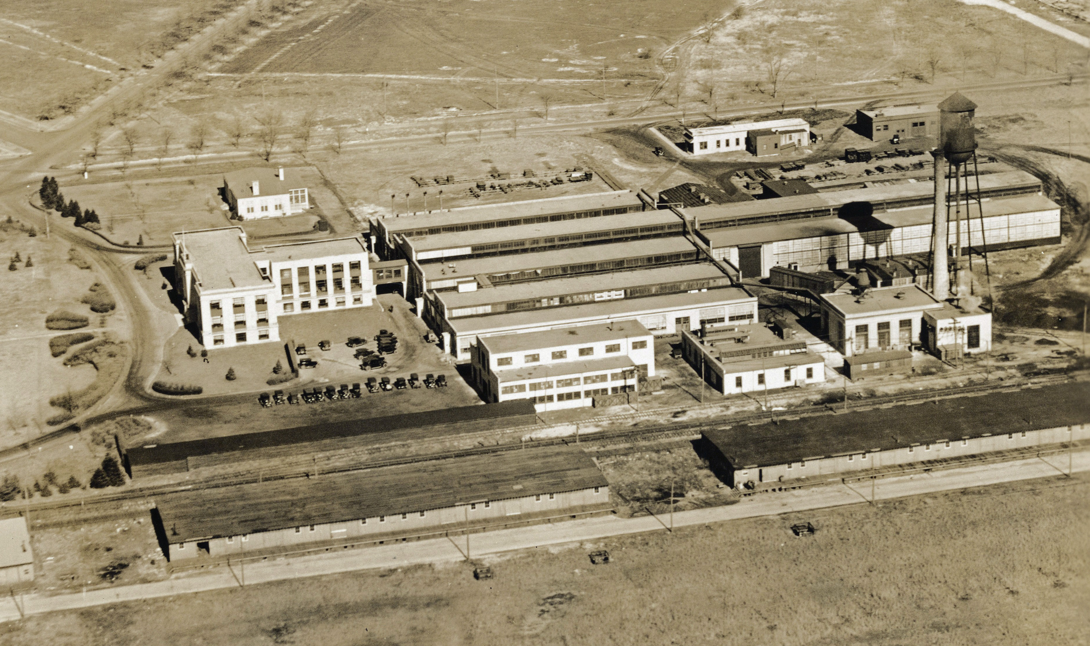
- What are the buildings located in the bottom of the aerial?
The Curtiss Engineering Corporation complex, built in 1918, was the first factory in the world for the research and develoment of aircraft. Most of the Curtiss buildings are still standing. They are considered the oldest surviving aircraft factory.
- What is the date of the Mystery Foto? Provide a rationale.
Circa 1925. Rationale:
-Curtiss Field buildings under construction that were completed in 1929 (see below).
-The porte cochere of the Garden City Lodge was not added until 1929.
-Construction of the homes of the Mott section in Garden City had not yet broken ground.
-The Intercollegiate Golf Course (1926) had not yet been developed.
Comments (15)
Congrats to Andy, Greg O., Tim Ivers, Frank Femenias (see Femenias' Findings), Ron Ridolph, Roy Warner, Sam Berliner III, Steve Lucas, Dick Gorman, Michael LaBarbera and Art Kleiner (see Kleiner's Korner) for identifying the Garden City location.
Kudos to Michael LaBarbera, Dick Gorman, Sam Berliner III, Art Kleiner, Frank Femenias for identifying the Curtiss Engineering Corporation complex around 1925.
Enjoy,
Howard Kroplick
Close-Ups

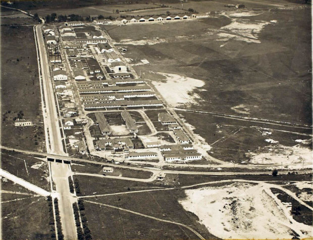
Hazelhurst Field
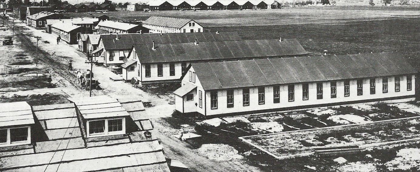
The military barracks of Hazehurst Field. Circa 1917
Curtis Field
1923 Belcher-Hyde Map
Circa 1929
Circa 1932
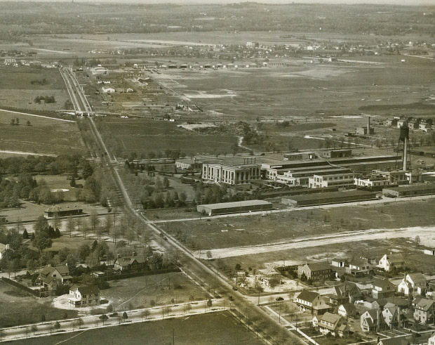
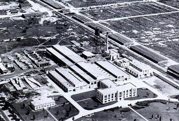
Curtis Engineering Corporation
Circa 1928
Circa 1932
Circa 1932
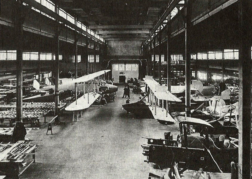
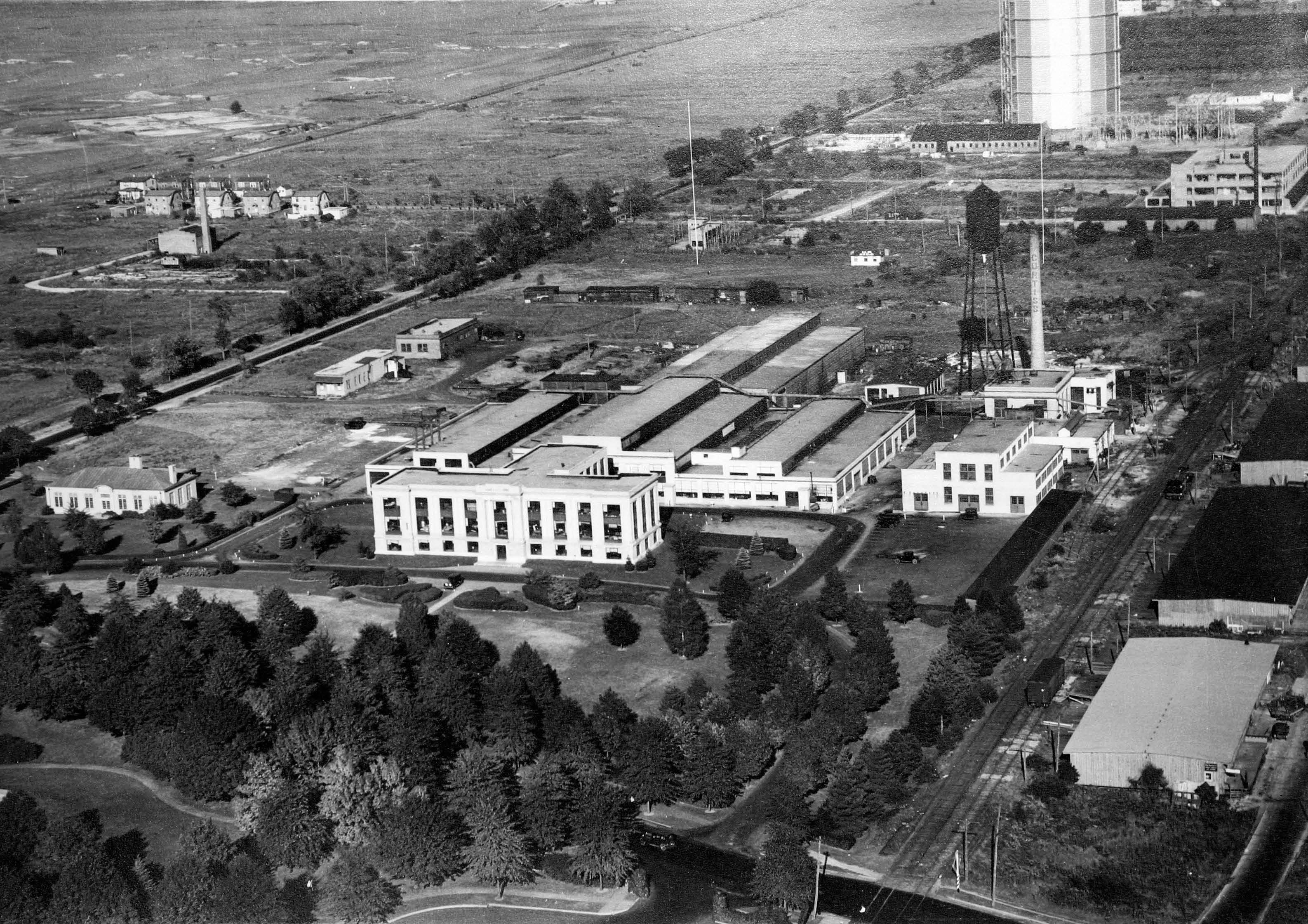
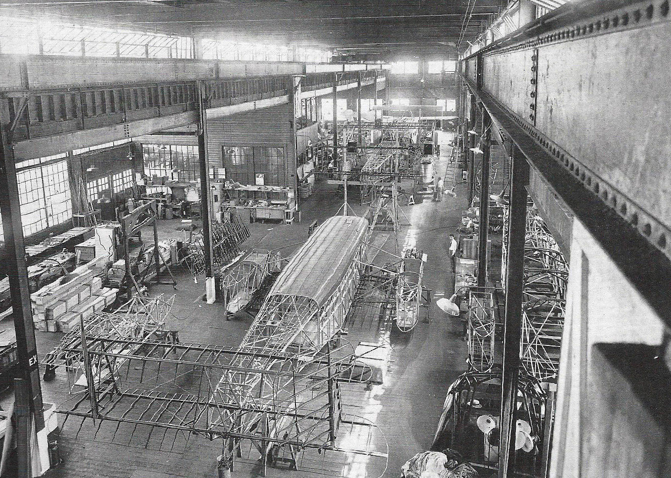
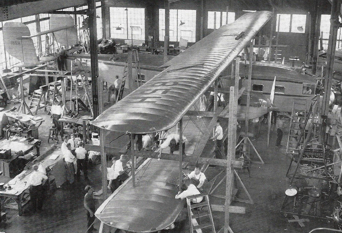
Inside the Curtiss Garden City Factory, Circa 1920
Circa 1928
Circa 1928
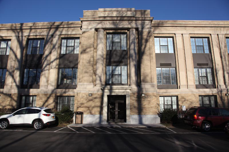
2013. The Curtiss Engineering Corporation headquarters building is standing today. The Curtiss Engineering Corporation name is still proudly above the entrance.
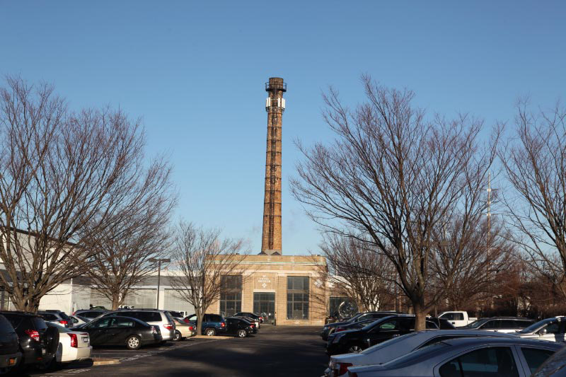
Look closely and C-U-R-T-I-S-S can still be seen on the smokestack.
Femenias' Findings (Submitted by Frank Femenias)
Then and Now
Kleiner's Korner (Submitted by Art Kleiner)
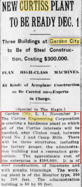
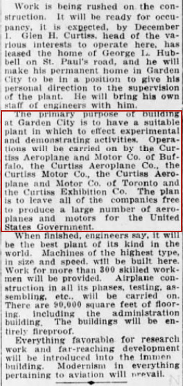
Brooklyn Daily Eagle, November 5, 1917
Brooklyn Daily Eagle, May 18, 1918
Brooklyn Daily Eagle, January 5, 1919
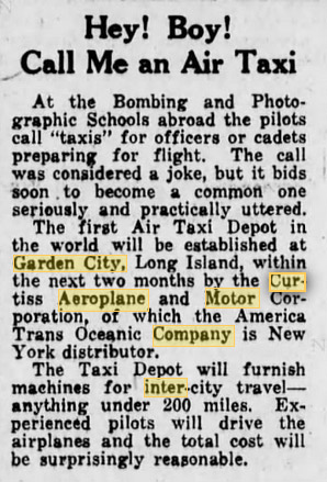
Brooklyn Daily Eagle, March 8, 1919
Brooklyn Daily Eagle, December 28, 1930


Comments
Garden City, NY
Curtis Aeroplane complex, bottom of photo, on Clinton Ave, GC. Stewart Ave west to east. VMP concrete double underpass on Clinton Ave. Buildings in the north part of photo include VHB toll house. Long Island RR tracks which is part of Central Extension.
Photo taking circa 1915 - 1920.
-Identify the location and orientation of the photgrapher
Over Garden City, looking North
-Identify the Motor Parkway structures and major roads
Clinton Rd Bridge, Managers house, Garden City Lodge. LIMP, Clinton Road, Stewart Ave.
-What are the buildings located in the top of the aerial?
Roosevelt Field
-What are the buildings located in the bottom of the aerial?
Curtiss Engineering Corporation
-What is the date of the Mystery Foto? Provide a rationale.
1932-This looks to be taken at the same time as Mystery photo #2 from Feb. 18 2013.
The Curtis Engineering looking north at Stewart Avenue and Clinton Road Garden City.
Top center is the 3 opening Clinton Road bridge carrying the LIMP over Clinton Road; to its right is the toll lodge and further right was the Parkway general manager’s residence.
Directly north of those structures was Hazelhurst Field.
Horizontally across the bottom below the Curtis plant are the railroad and Commercial Avenue.
Fantastic view of Garden City looking north at the Clinton Rd/Stewart Ave/Osborne Rd intersection. Admiring all the open spaces. Sharpest aerial view yet of the Garden City Lodge and Supt’s house. It appears his car hood was open. I can almost make out the writing on the Clinton Rd bridge. Is that a second Motor Parkway sign by the bridge? The white roadway just left of the bridge is former Hospital Rd, and the roadway intersecting just after the bend is former South Street, both of Camp Mills Base hospital (1918-1919). Also seen just north of Osborne are the two dirt roads converging at Clinton Rd, once used as a shortcut to the hospital. Included are Commercial Ave, Central RR, and Motor Parkway. The brick smokestack by Central RR still exists today, but now braced with reinforcement and an array of cellular antennas. The Mott Section here is still undeveloped, so dating this aerial in the mid ‘20s. The buildings on top are offices of Roosevelt Airfield, and buildings on bottom unknown. Keep ‘em comin’!
Just a guess. View is northwest from the south side of Stewart Ave. in Garden City. I think the building south of Stewart Ave. and to the west is still extant; I haven’t been in LI for 15 years. In any event, the area shown in the top of the photo, based upon my guess, would be the current Roosevelt Field.
This us the Cerro wire factory in Weatbury just north of the LIE . Keep up the great vintGe photos. Thanks,Gene Perry
Looking north in Garden City towards Roosevelt Field.
General Manager’s office, Garden City Lodge, Clinton Rd. Motor Parkway Bridge (don’t think the Mayan Ruins are in the shot, or had been built yet). Major roads - LIMP, Clinton Road, Russell Road, Commercial Avenue, Stewart Avenue.
Buildings at top are part of the Curtiss Field. Buildings at bottom are the Curtiss Engineering Corp./Curtiss Aeroplane and Motor Co.
Late teens, early 20s. Before Intercollegiate Golf Course in 1926, limited development west of Clinton Road. Low growth among trees/shrubs.
I’m guessing it’s the Grumman plant with the administration building facing north on Stewart Ave., Bethpage. Photographer is facing east. Time period is late 1930s, since Grumman moved from Farmingdale to Bethpage in 1936.
Another “HA”; I worked in that building ca. 1955-56! That’s the former Curtiss Aeroplane & Motor Co. (later Oxford Filing/Pendaflex) plant on the southeast corner of Clinton Road and Stewart Avenue In Garden City. The second-story bridge between the office and plant is still evident today (it once held the wind tunnel throat). We’re over today’s Commercial Avenue looking (LI) NNE. The buildings to the north are probably the stables for the country club. Clinton runs center left to top center and the LIMP runs above center left to center right (W to E). The LIMP structures are the Clinton Road and trolley bridge, the super’s office, and the toll lodge. Probably early ‘20s as the Mott Section hadn’t been developed yet. Love to know what that big building above the bridge might be. Sam, III
Oops! Forgot to identify Stewart Avenue running left to right (W to E) above the Curtiss plant, the Central RR of LI line between the plant and the two warehouses (still standing), or Commercial Avenue in front of the warehouses (which means we’re over today’s Brook Street), and to thank Richard P. for these fantastic aerials. Sam, III
We’re over East Garden City looking north with the LIMP coming in from the north and curving east with the bridge over Clinton Road, general manager’s office, and Garden City Toll Lodge all visible. The buildings at the top belong to Curtiss Air Field and the bottom structures are the Curtiss Engineering plant. Along with Clinton Road, there is Stewart Avenue, an early Commercial Avenue and the road west of the LIMP leading to the Army hospital. Since Curtiss Engineering was built in 1918 and Curtiss Field appears to be still under construction, I’ll guess the date to be 1918, maybe 1919.
Mystery Foto #32… We are in the Garden City/Mineola area with the photographer looking North West. The Clinton Road Motor parkway bridge is shown in the top, center. Tree lined Clinton Road shows in the upper left quadrant of pic. The building in the top of photo is Roosevelt Field airport. The Curtiss Engineering Corp buildings are seen at the bottom of the aerial. As a guess on the date I would say between 1925 and 1928.
Mystery Foto # 32….We are in the Garden City/Mineola area with the photographer looking North West. The Clinton Road Motor Parkway bridge is shown in the top, center. Tree lined Clinton Road shows in the upper left quadrant of the pic. The buildings seen at the top of Photo are Roosevelt Field airport. The Curtiss Engineering Corp buildings are seen at the bottom of the aerial. As a guess on the date I would say between 1925 and 1928.
Looking north at Clinton Road from south of Commercial Avenue GC. Curtiss Factory is south of Stewart Avenue, Long Island Motor Parkway at the bend over Clinton with its 3 section bridge, the entranceway to LIMP and the office and Toll House. No Portico on the toll house means it was the early 1920s. Great pic it shows how hardly anything was there after WW1.
Mike - Excellent observation! I missed it. NO portico!
Mike - Excellent observation! I missed that. NO portico. Great eagle eyes!
Speaking of eagle eyes and no portico (bravo!), I see that the “second-story bridge between the office and plant” (Curtiss) now has a first-story enclosure. Views looking down into the old plant, such as the ‘20s and ‘28s’s above, were taken from the east end of that bridge. Sam, III
Interesting 1926 NY Times article about the sale of Curtiss Field to developers. Mentions the Motor Parkway.
Ah, rampant sexism reared its ugly head - “an organization of Yale, Princeton and Harvard men”! Worse, of course, is that no one (men, anyway) even noticed or cared. Frank or somebody - please tell us more about that august body. Unrelated - happily, not all the hangars were demolished. Also, please remember that south side of the throat of the historic wind tunnel is most-likely still buried in the inner south wall of the bridge; it was there when I was and and was wall-boarded over shortly thereafter, ca. 1957 (I am soooo old - - - ). :·) Sam, III
As long as I’m going so far back in memory, I should once again note that the little building on Stewart just north of the engineering offices became (or was the site of) the LI Trust Co. bank, later Franklin-cum-European American. and now Chase. If the field of view extended just a bit to the east (right), you might see the big LILCO gas holder (when was that erected?). Sam, III
Art - Thanks again for sharing these historic news clips. They’re priceless and hard to find. So much info is gained from them to help visualize a clearer prospective of what really happened over the years and how things eventually established. Please keep ‘em goin’.
Sam III - From what I’ve gathered the lot mentioned is the area of Roosevelt Field Airfield (Mall today), and the immediate area south bounded by Stewart Ave and Raymond Ct. The Mott Section (west of Clinton Ave) is out of this. Very few houses would eventually be built in this small area, contrary to the original plan, and most construction would eventually be contributed to the creation of Roosevelt Field Mall, New York State’s largest shopping mall. I welcome any response here.
I forget to mention, no one at the time seemed apt to save the historic Hangar 16 from demolition. Photos of it still exists, the hangar housing Col Lindbergh’s plane to cross the first solo flight across the Atlantic to Paris.
Thanks Frank - yes, I’m always amazed at what I find in these historic articles. And many times one historic mention leads to a whole other avenue of investigation.
Now that Howard (thanks much Howard) has given us the ability to attach images directly, I’ll add more as I uncover relevant ones. Thanks
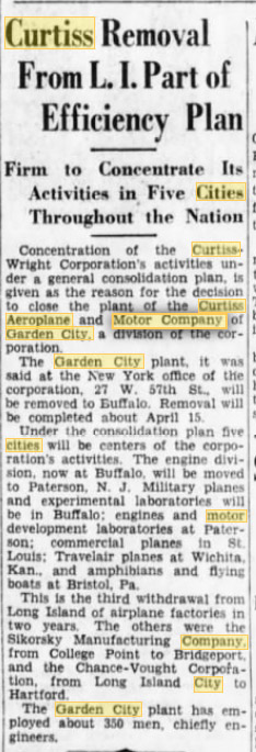
Here’s another article from the New York Times of April 26, 1931 discussing the closing of the Curtiss plant 14 years after its opening. Let me know if you are able to access the article form this url.
https://search.proquest.com/docview/99426100?accountid=37272
No joy, Art. “Barcode Required”. What a kick I get out of this thread; floods of memories! Let’s not forget the USMC installation at the east end of the Curtiss property on Stewart and the Cyclone-fenced parking lot directly across Stewart from that, just east of Raymond Court, later a LILCO lot (still there). While I’m at it - Frank, that area to the west of Clinton is very much the Mott Section and, except for Triangle Park, is fully and heavily developed. Also, on your “today” aerial, “Central RR” should be “Central Branch” or “Central Extension” or “Garden-Mitchell Field Secondary Track”, as you wish - howzat for nit-pickin’? Sam, III
Art - One needs to enter a barcode from an institution or log on to Proquest to access the article. I happen to have a Proquest account thru my local library ( institution ), but realize that others may not.