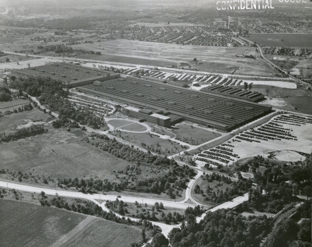
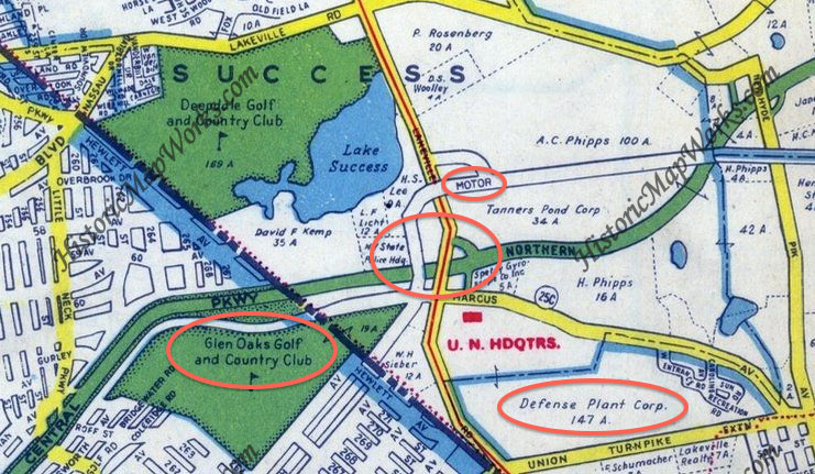
Mystery Foto #11 Solved: Hundreds of Automobiles Seen in This 1952 Lake Success Aerial
This weekend's Mystery Foto was another amazing aerial from Fairchild Aerial Surveys.
Mystery Foto questions:
- Identify the location and orientation of the aerial
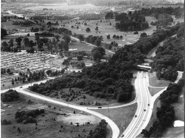
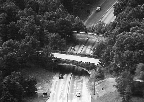
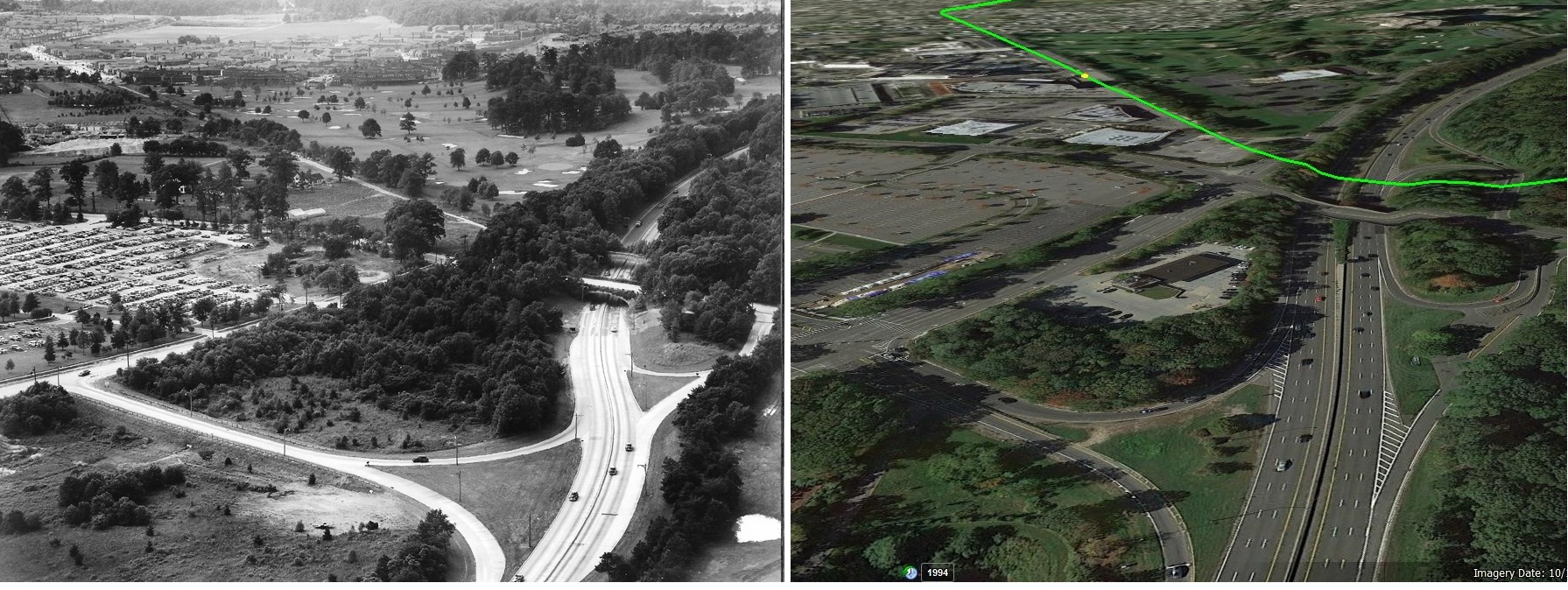
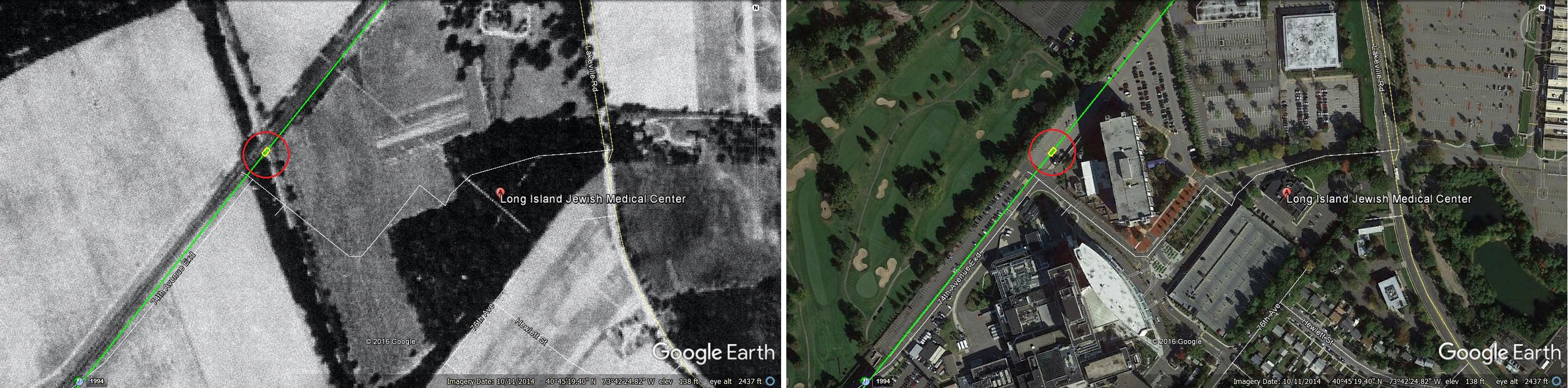
Lake Success looking south/west at Lakeville Road with Northern State Parkway on the right. The two Robert Moses bridges over the Northern State Parkway can be seen on the right; the easterly one is Lakeville Road and the westerly one was the abandoned bridge for the Long Island Motor Parkway.
- Relate the aerial to Long Island Motor Parkway and the Vanderbilt Cup Races
Remnants of the Motor Parkway can be seen going into Queens. See below Femenias' Findings.
Lakeville Road seen in Mystery Foto was part of the 1905 Vanderbilt Cup Race course.
- Why are hundreds of automobiles parked in the Mystery Foto?
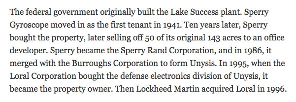
This was the parking lot for the Sperry Gyroscope Plant.
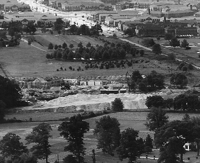
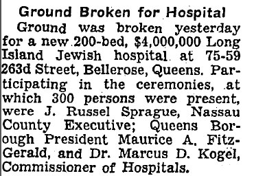
- What facility was being built in the aerial?
The Long Island Jewish Hospital.
- Identify the golf course.
Glen Oaks Golf and Country Club.
- What year was the aerial taken? Provide a rationale.
June 10, 1952. Provided on the back of the photo. Only kidding, the rationale includes: the four lanes of the Northern State Parkway, construction of the hospital building and level of growth seen on the Motor Parkway bridge.
Comments (14)
Congrats to Joe Oesterle, Greg O., Brian McHale, Steve Lucas, David I, Tim Ivers, Sam Berliner III, Art Kleiner (see Kleiner's Korner), Edith Klarmann, Dick Gorman, Tom Hutchins, Frank Femenias (see Femenias' Findings) and Steven Vilardi for identifying Lake Success and the orientation of the aerial. Kudos to Steve Lucas, Art Kleiner and Frank Femenias for linking the Mystery Foto to the 1905 Vanderbilt Cup Race course (Lakeville Road).
Enjoy,
Howard Kroplick
Close-Ups
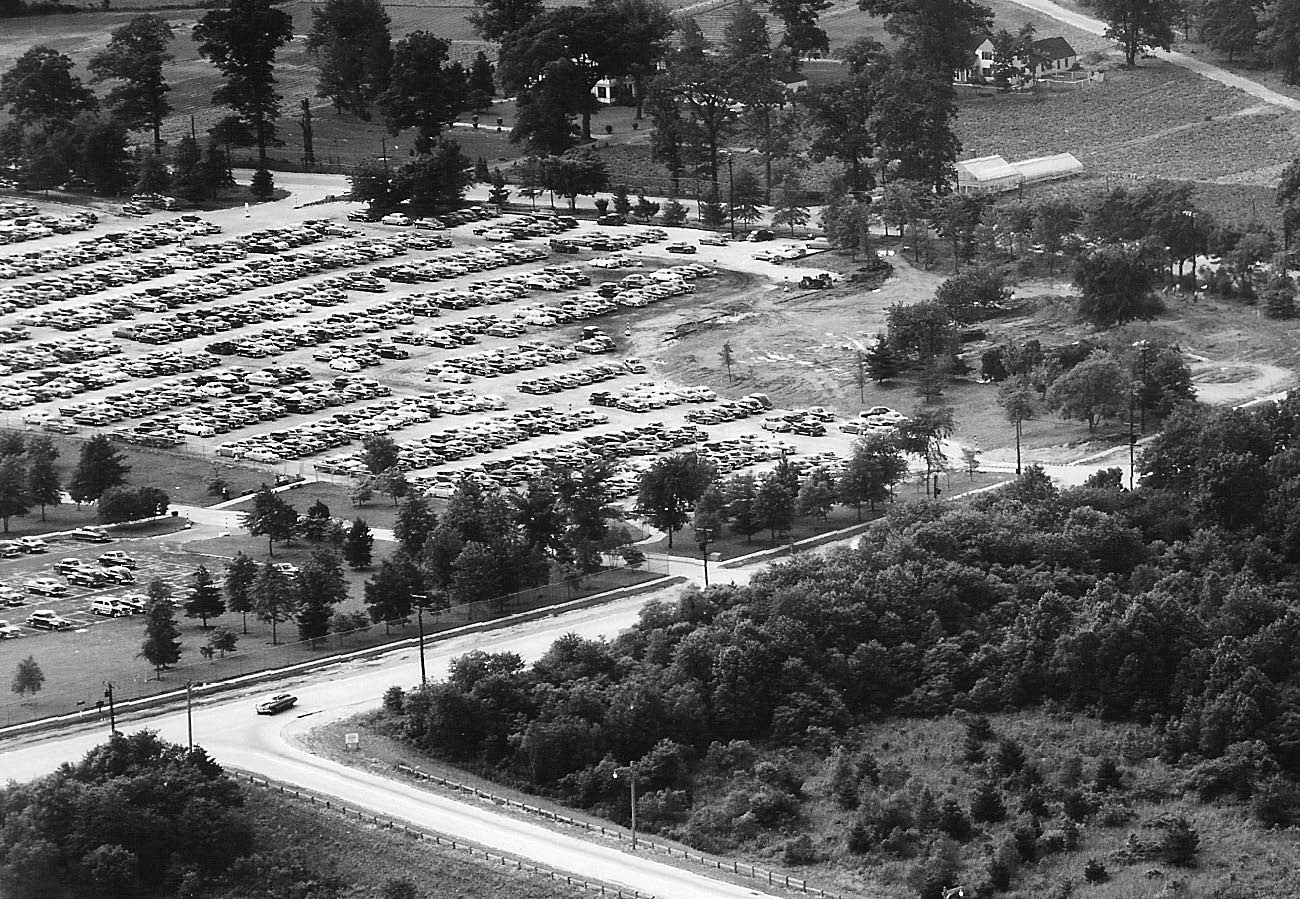

The Sperry Gyroscope Plant in Lake Success on September 27, 1952
As noted by Sam Berliner III, this 2016 Mystery Foto shows a similar view highlighting the Sperry Gyroscope Plant.
1905 Vanderbilt Cup Race Course
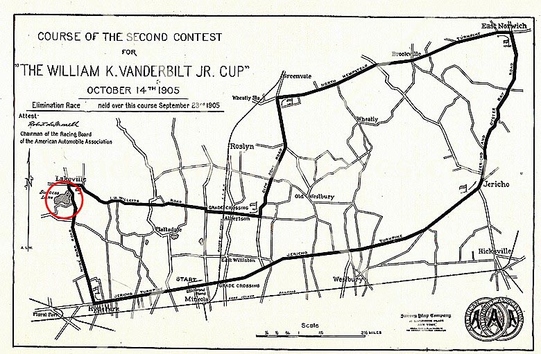
The section of Lakeville Road in the Mystery Foto was part of the 1905 course.
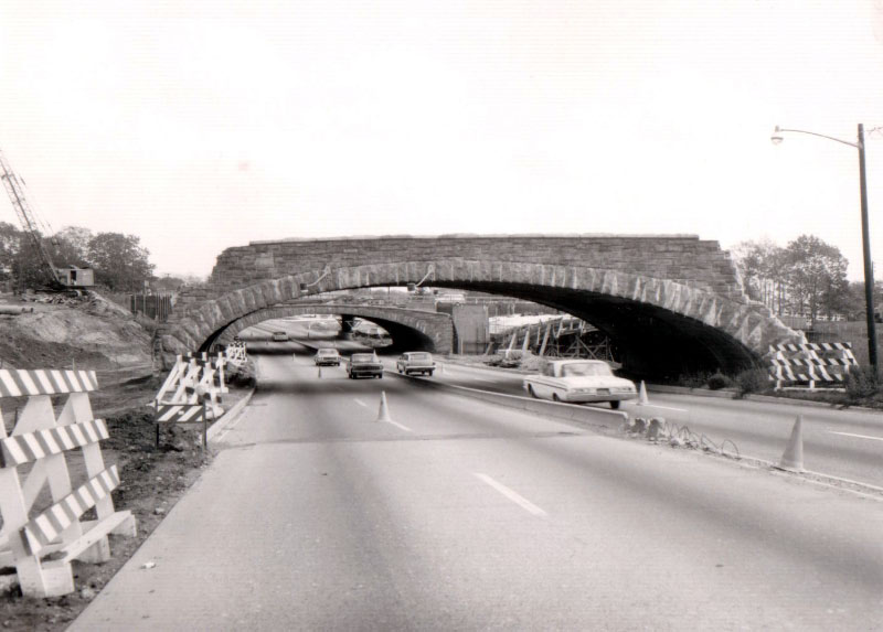
Northern State Parkway Motor Parkway Bridge
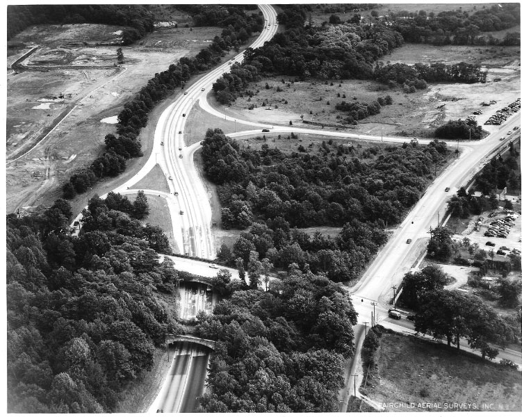
A 1954 view of the area looking east.
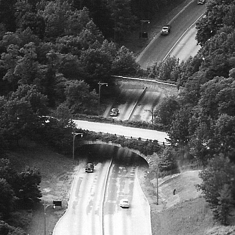
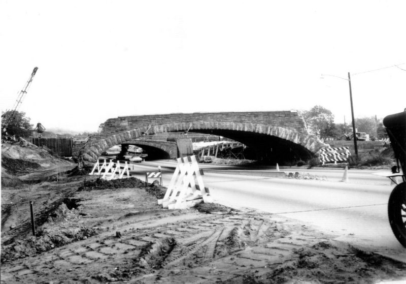
More trees growing on the Motor Parkway bridge.
The Motor Parkway bridge being taken down in the 1960s.
Femenias' Findings (Submitted by Frank Femenias)
Then & Now
Kleiner's Korner (Submitted by art Kleiner)
1946 Map
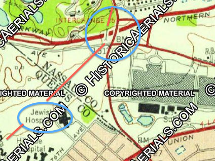
1957 Map
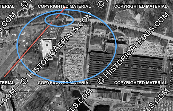
1966
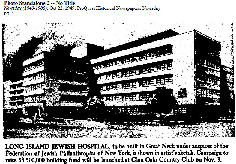
Newsday, October 22, 1949
The New York Times, December 11, 1950
The New York Times, May 21, 2000


Comments
Northern State parkway looking west, at Lakeville Rd. The LIMP bridge can still be seen crossing the NS. The picture is before 1969.
-Identify the location and orientation of the aerial
Above the Northern State Pkwy looking West down at the two Robert Moses bridges built over the pkwy in Lake Success. One for the LIMP, the other for Lakeville Road.
-Relate the aerial to Long Island Motor Parkway and the Vanderbilt Cup Races
The bridge farther away is a LIMP bridge, as well as Vanderbilt original Deepdale estate being off to right of the photo.
-Why are hundreds of automobiles parked in the Mystery Foto?
Parking lot for the Sperry Plant ( where my Grandfather was employed as a gyroscope engineer)
-What facility was being built in the aerial?
The beginnings of The Long Island Jewish Hospital.
-Identify the golf course.
The former Glen Oaks Club is now the golf course for North Shore Towers.
-What year was the aerial taken? Provide a rationale.
1952 -starting construction of LIJ, Sperry plant, and original exit/entrance ramps help date the photo. It also helps that the aerial has been used numerous times in other posts.
Northern state parkway, lakeville rd overpass, motor parkway overpass just north of it. Sperry property with the cars parked, LIJ hospital being built? 1945?
In this photo we’re over the Lake Success area looking west with the entrance / exit ramp of the Northern State Parkway onto Marcus Avenue in the foreground. The abandoned LIMP bridge over the NSP can be seen just above the Lakeville Road bridge with a LIMP remnant heading toward the upper left corner. This section of Lakeville Road was part of the course for the 1905 VC race. The cars in the parking lot probably belong to Sperry Gyroscope workers or possibly U.N. delegates (or workers) during the time that the U.N. temporarily used the Sperry plant for its headquarters. The facility under construction is the L. I. Jewish / Hillside Hospital. I think the golf course was the Glen Oaks Golf Club. Judging by the hospital construction and some of the visible cars, the photo is probably from the early 1950’s, maybe 1952.
Well 1st off, I don’t think that the center right side of the pic is a full 500 feet south of last weeks Great Neck Lodge in snow Mystery Foto #10!
We’re looking west, southwest at the Northern State Parkway in Lake Success. The lower overpass bridge (white) is Lakeville Road. Just above that (darker) is the abandoned LIMP bridge, to the left of the trees, at a diagonal to the top left corner of the pic is the route of LIMP. Not sure of the name of the golf course above that, I think Glen Oaks, but that’s where the hi-rise North Shore Towers is now. Back down toward the bottom, this eastbound Lakeville Rd exit out to Marcus Ave. was built in 1952. Before that it was just about 2 car lengths this side (east) of the Lakeville Rd bridge. I’ve seen pics during the construction of this exit/entrance with all of the heavy road grading/earth moving equipment, contractor sheds, etc. quartered on the east side of it & it looks like the ground is still scarred from it there. Also looks like a remnant of the original exit (dirt maybe) is still seen just this side of the bridge so I’m gonna guess the pic is from 1952 or ‘53. The UN went to Fresh Meadows in 1951 so the parking lot at left is Sperry Gyroscope, changed sometime in the ‘50s to Sperry/Rand Corp., bordered by Lakeville Rd. The triangle between Lakeville Rd. & LIMP is the Schumacher farm. To it’s left would be the start or expansion of the L.I. Jewish Hospital (formed 1949).
Looking west over Northern State Parkway in 1952
LIMP bridge is topmost bridge left to right
The Sperry parking lot on the left is full of autos
Long Island Jewish Hospital is under construction, top left
The golf course is Deepdale
That’s almost Mystery Foto #28, the Sperry Gyroscope plant in Lake Success on 27 Sep 1952! This is earlier, probably during WWII, wherefore all the cars, looking southwest across Lakeville Road with the recently-closed LIMP just beyond and No. State Parkway up the middle. It’s well after Easter 1938 because heavy shrubbery is growing on the LIMP bridge over No. State. The golf course is the Glen Oaks Golf Club (now the North Shore Towers complex). The George Vanderbilt VCRs had been run just previously. Hillside Hospital (now LIJ/NS/Zucker-cum-Northwell) is going up across Lakeville Rd. My, you ask a lot of questions; I thought you knew all this stuff, Howard! :·) Sam, III
Identify the location and orientation of the aerial: Lakeville Road, Northern State Parkway - Lake Success/New Hyde Park. View looking west, south of the parkway.
Relate the aerial to Long Island Motor Parkway and the Vanderbilt Cup Races: Motor Parkway is running parallel to the golf course and going over Marcus Avenue and the Northern State Parkway. Second bridge with trees on it is the Motor Parkway bridge. Area included in the 1905 Vanderbilt Cup Race course.
Why are hundreds of automobiles parked in the Mystery Foto? Parking lot for the Sperry plant located on Lakeville Road.
What facility was being built in the aerial? Long Island Jewish Hospital (originally planned as a 200 bed facility).
Identify the golf course. Glen Oaks Golf and Country Club
What year was the aerial taken? Provide a rationale. 1951 - groundbreaking for the hospital was in December, 1950.
Appears, most likely, temporary headquarters of UN at Lake Success, Northern State Pkway, with LIMP above (foto - 3/4 to right and slightly above center)... all, as earlier seen in July 11, 2016 issue of Vanderbilt Cup Races.
Probably wondering where I’ve been,very busy lately,doing a lot of things,very active here now. I try to keep up with you on here,I have some spare time now,so I’ll take a crack at this. By the looks of the cars,the aerial was taken in the late 40s. Trying to figure out where this is and it’s very confusing,could be Northern or Southern State,I’m not good at this at all,am I? Probably have seen this area so many times too,it looks all the same to me. As to your Tucker,I’m glad to see that you were interviewed by Newsday,let be known that you have this car,it’s another historical thing for Long Island.
Mystery Foto #11…Location is around Lake Success. The aerial shows Fresh Meadows Golf Course. This area was western terminus of the LIMP. Don’t know why hundreds of cars were parked there. Don’t know what facility was being built.The Fresh Meadows Golf course pic was taken on June 10, 1952.
looks like marcus av Lakeville rd northern state the 1st UN bldg later Fairchild?
The beginning of the Northern State Parkway at Lake Success looking west. The furthest bridge west overwhelmed by Mother Nature is the abandoned Motor Parkway, which continues diagonally southwest alongside the golf course (North Shore Country Club, formerly Willie K’s Deepdale Golf Club). The first bridge is Lakeville Rd. Ground breaking may have begun for Long Island Jewish hospital (white dirt), also alongside the Motor Parkway opposite the golf course, and the location of the Vanderbilt golfway bridge. Automobiles could be parked at the Sperry Gyroscope Plant (off the photo on left). The NSP exit/entrance at bottom is Lakeville Rd exit 25, later home of the NYS Police barracks. Around 1952 after the NYS Police barracks moved into the patch of trees in the foreground. The 1905 Vanderbilt Cup Race used Lakeville Rd for a tire changing station. Look out today for the red light camera on Lakeville Rd/Marcus Ave.
From Steven Vilardi:
• Identify the location and orientation of the aerial
o Looking southwest, northern state pkwy, Marcus ave at lake view red exit
• Relate the aerial to Long Island Motor Parkway and the Vanderbilt Cup Races
o Long Island Motor Parkway is a little the north by Vanderbilt house, lake success and great neck high school
• Why are hundreds of automobiles parked in the Mystery Foto?
o They are parked at the sperry defense plant.
• What facility was being built in the aerial?
o It looks like Long Island Jewish hospital is being started on lake ills red
• Identify the golf course.
o What year was the aerial taken? Provide a rationale.
- I would say earlier than 1953
in 1952 the UN Secretariat was still in 1111 Marcus Av, Lake Sucess and this was their parking lot… https://www.facebook.com/1111marcus/
Hi Howard,
I don’t know if comments are still excepted as it’s now after your reveal but…
Something has got to be wrong with 1 or both dates here. You’re showing this weeks Foto with the new eastbound Lakeville Rd. exit as being June 10, 1952, 3 1/2 months before the Sept. 27th Sam Berliner III noted 2016 S/E Foto (above) with the old exit & no sign yet of the new. Robert Moses could & did work fast when he wanted to BUT this weeks Foto has to be at the very least 1-2 months after the S/E Foto assuming they started working the day after it was taken.
p.s. if you enlarge the 1966 aerial above, you can still easily see the remnant of the old exit.
It was particularly dangerous during evening rush hour as cars trying to exit got backed up all the way from the signal at Lakeville Rd onto the right lane (of only 2 eastbound lanes) of the parkway under both bridges (no room for any kind of shoulder with those bridges) on a curve that starts back by the police barracks. In those days, the parkway wasn’t always at a crawl even during rush! Even still, 50% of eastbound capacity was blocked. It was probably highlighted while the UN had been there but already a continually increasing problem post WWII with suburban migration.
David I - You are correct, the Great Neck Lodge is only 300ft. east of Lakeville Rd but is just north (right side) of this aerial and out of view.
Hi Frank. Your comparison aerials bring back that day when we were tracing the LIMP. Next mission…...Mayan Ruins or Petit Trianon! Whatever comes first!
David I - I misunderstood, the lodge is also roughly 550-600 feet north of this aerial.
Brian - We’ll be at Ronkonkoma as soon as the snow melts. Hopefully the LIMPPS will join as well, including Howard. Bob DeStefani will try to make the meet as well. This would be a most informative experience for all!
Strange that though the Motor Parkway bridge is “being taken down in the ‘60s,” there is a 50 year old car parked on the shoulder
Yes, Frank. You could just see the rear of that old car. I like to think the auto belonged to a LIMPER like us. He or She was probably the photographer capturing the demolition of the bridge.
Brian - My thoughts are exactly the same. I could definitely picture that! Could be from the Model A Ford club of Long Island.