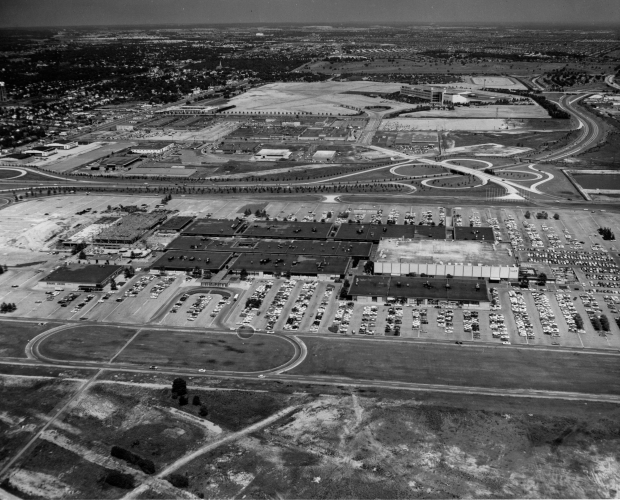
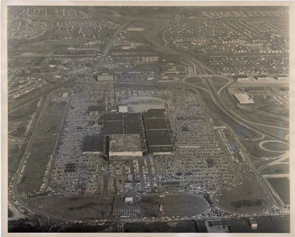
Mystery Foto #29 Solved: An Amazing Aerial of the Open-Air Roosevelt Field Center Circa 1961
The Cradle of Aviation Museum challenged you to identify this amazing aerial from their archives.
Mystery Foto questions:
- Identify the location and orientation of the aerial.
The open-air Roosevelt Field Center in East Garden City looking east to Westbury and East Meadow.
- Link the aerial to the Vanderbilt Cup Races.
Sections of six Vanderbilt cup races can be seen in this Mystery Foto: 1908, 1909, 1910, 1936, 1937 and 1960.
- Link the aerial to the Long Island Motor Parkway.
The right-of-way for the Motor Parkway can be seen on upper right section of the Mystery Foto. A small section of the Meadowbrook Parkway was built on the Motor Parkway right-of-way.
- Identify a remaining section of the Motor Parkway.
A section of the Motor Parkway was repaved and used as a road for the Mitchel Gardens complex.
- How many airplane hangars are in the aerial?
Four hangars can be seen on Old Country Road.- three east of Meadowbrook Parkway and one hangar about one mile east.
- Where is there an amusement park in the aerial?
In the Roosevelt Field Center east of Grand Union, there was a skating rink and carousel.
- What was the date of the aerial? Provide a rationale.
Based on the first-floor construction of the Gimbels building, the photo was taken around 1961-1962.
Rationale:
-The open-air Roosevelt Field Center was officially opened on August 29, 1956.
-The new Roosevelt Raceway for harness racing opened in August 1957.
-Gimbels opened on August 20, 1962.
-Construction to enclose the Roosevelt Field Center began in April 1967 and completed in June 1968. It was renamed the Roosevelt Field Mall.
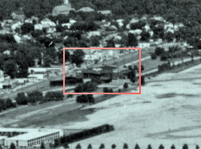
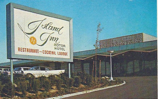
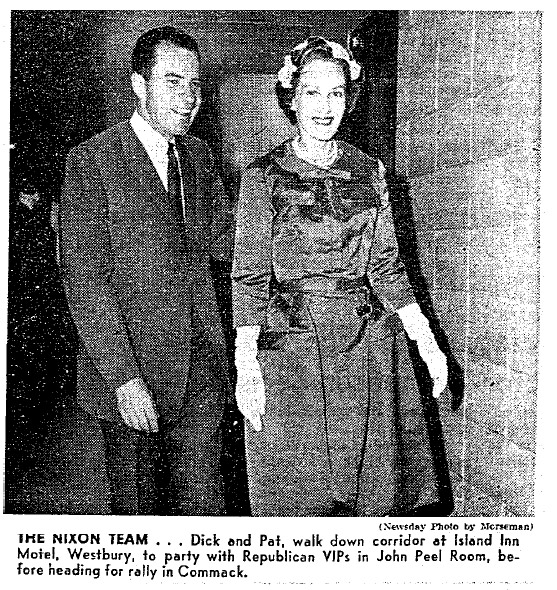
- Identify the famous motel in the photo where Howard Kroplick shook the hand of Richard Nixon. Impossible bonus question: What date did this occur? The answer is available online!
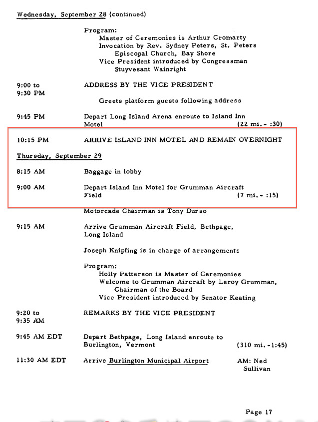
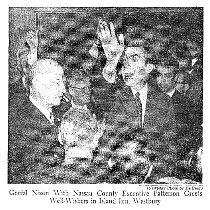
Ten-year old Howard Kroplick and his father shook the hand of Vice President Richard Nixon at the entrance to the Island Inn Motor Hotel around 6:00 pm on September 28, 1960. Future President Nixon was campaigning on Long Island that day and spent the evening at Long Island's "luxury motor hotel".
Comments (16)
Congrats to Joe Osterle, Adam Frank, Mile Appice, Holly Lapinel, Sam Berliner III, Brian McCarthy, Art Kleiner (see Kleiner's Korner), Steven Vilardi, Bob Hoffman, Steve Lucas, Greg O., Roger Price, Tim Ivers, Brian McCarthy and Frank Mendyk for identifying Roosevelt Field.
Kudos to Mike Appice, Brian McCarthy, Art Kleiner and Tim Ivers for identifying the Island Inn as the motel where I shook hands with Vice President Richard Nixon. Art Kleiner even had the correct day and date!
Enjoy,
Howard Kroplick
Today: Location
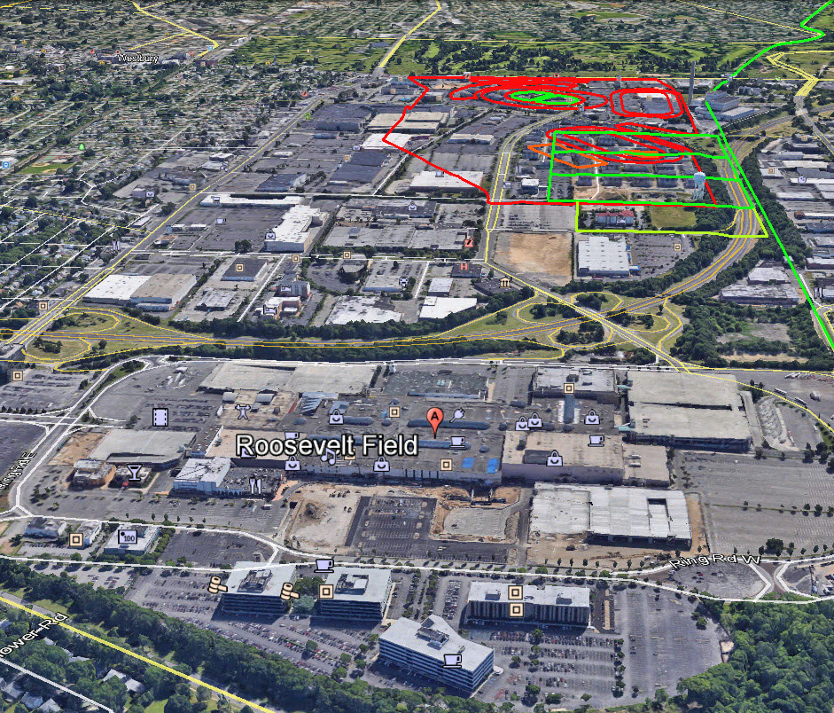
Roosevelt Field looking east. Old Country Road is on the left. Macy's deaprtment store is still an anchor to the now enclosed shopping mall.
Then: Close-Ups
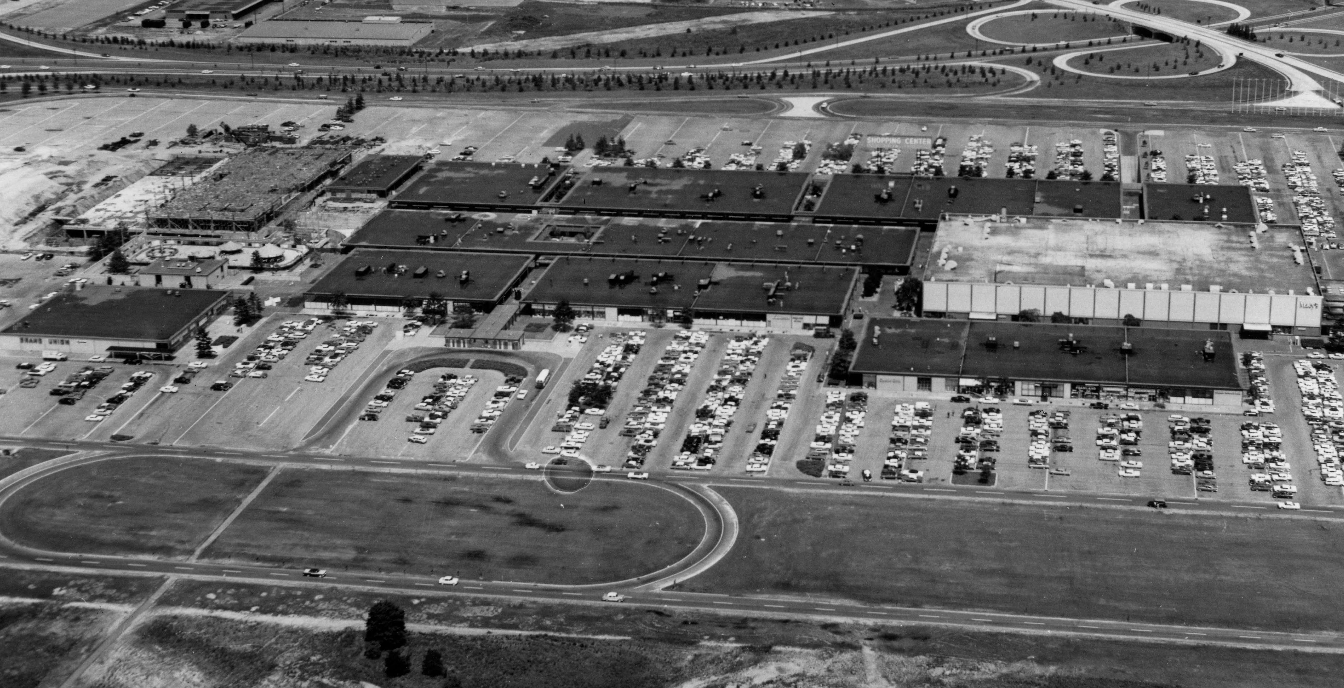
Roosevelt Field with Macy's on the right.
A small amusement park can be seen on the left behind the Grand Union. Further east, Gimbels is being built.
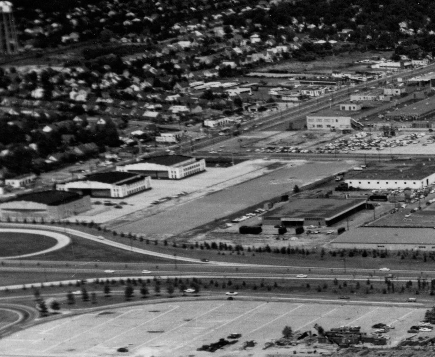
Three still standing hangars of Roosevelt Field.
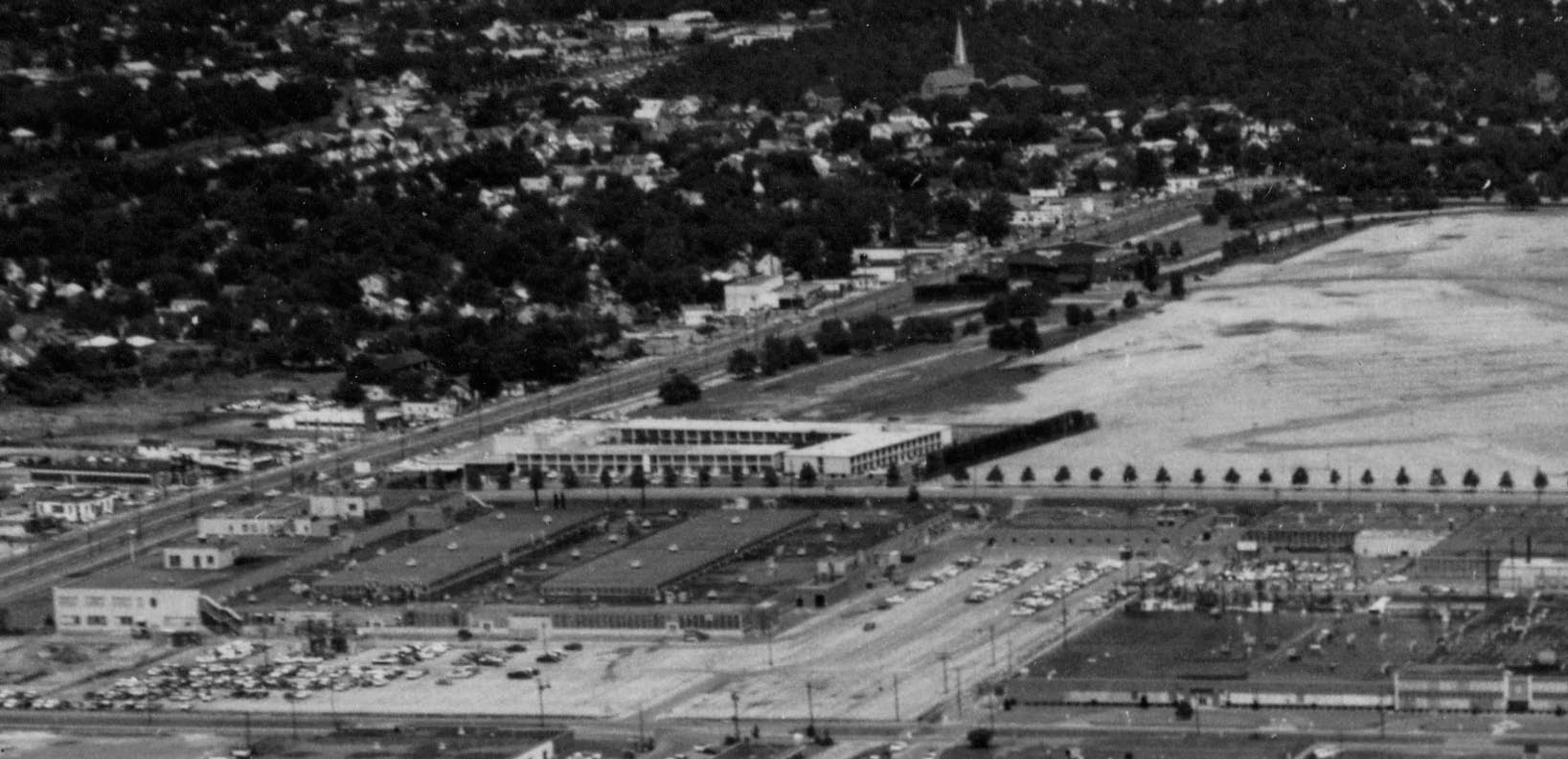
The Island Inn Motor Hotel. Another Roosevelt Field hangar can be seen further east off Old Country Road.
On front of the Island Inn was the American-Bosch/ARMA building which later became the worldwide Avis headquarters.
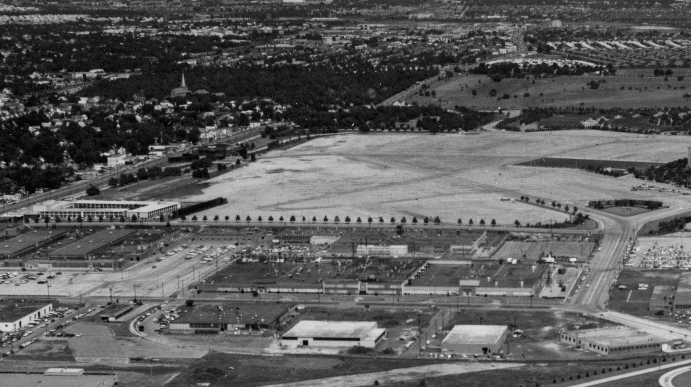
The site of the first Roosevelt Raceway used for the 1936 and 1937 Vanderbilt Cup Races.
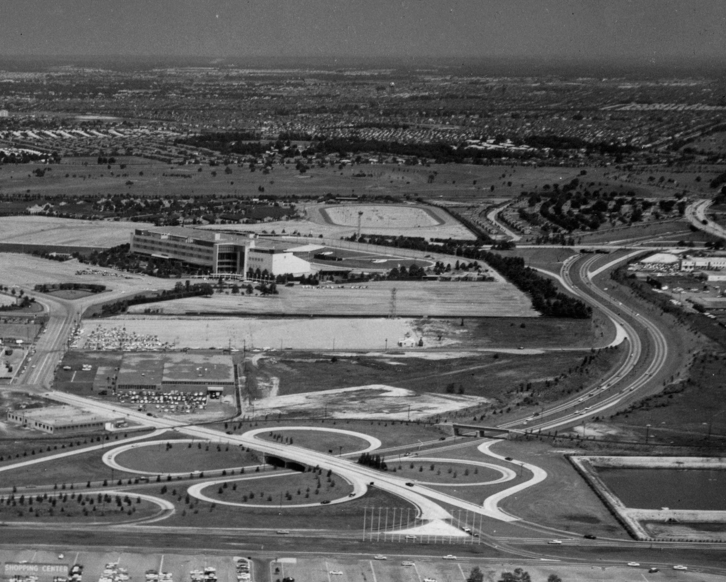
Roosevelt Raceway used for harness horse racing. The 1960 Vanderbilt Cup Race course was held in the parking lot.
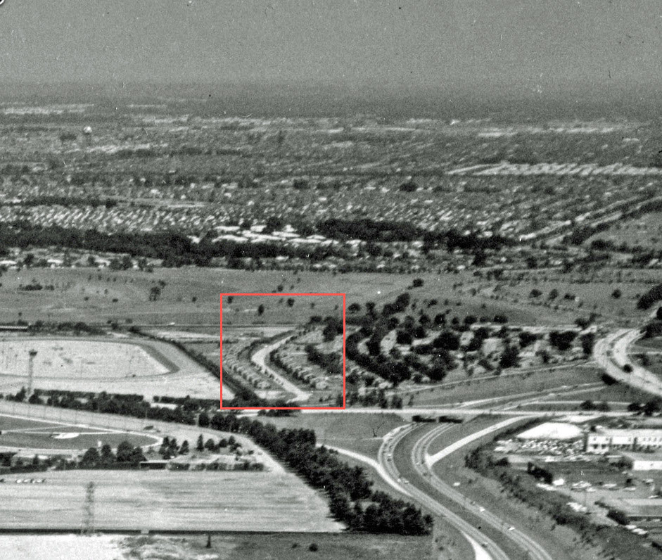
A section of the Motor Parkway used as a road for Mitchel Gardens.

Vanderbilt Cup Race Courses
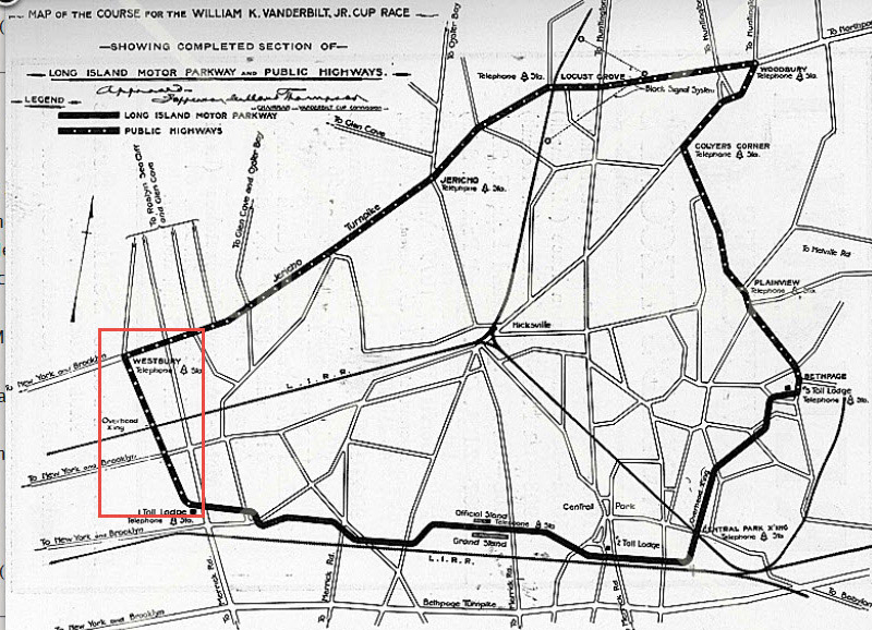
The Mystery Foto captured the sites for six Vanderbilt Cup Race courses:
1908 Vanderbilt Cup Race
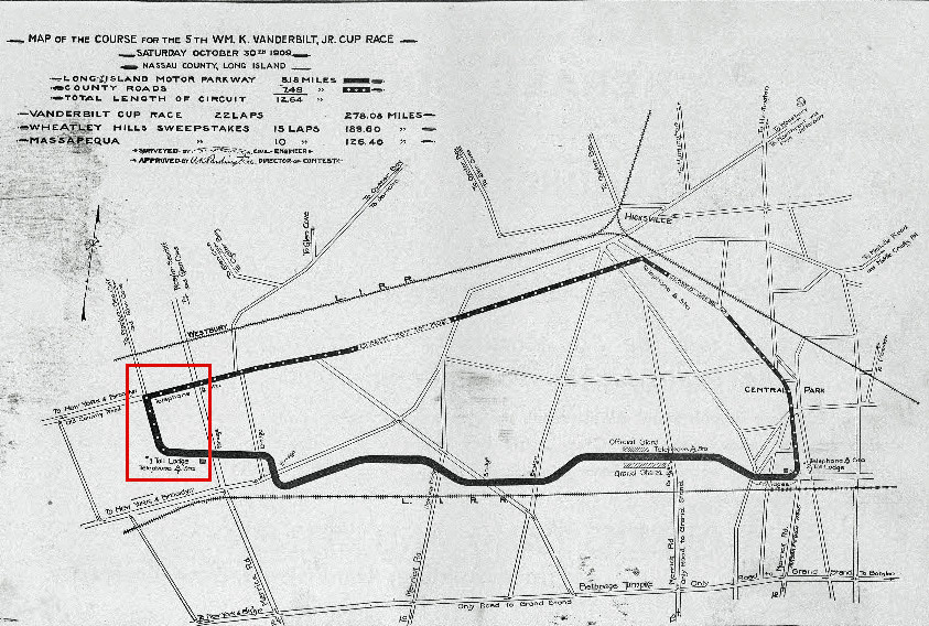
1909 and 1910 Vanderbilt Cup Races
1936 and 1937 Vanderbilt Cup Race
Note: The Roosevelt Field hangar used as a garage for the races.
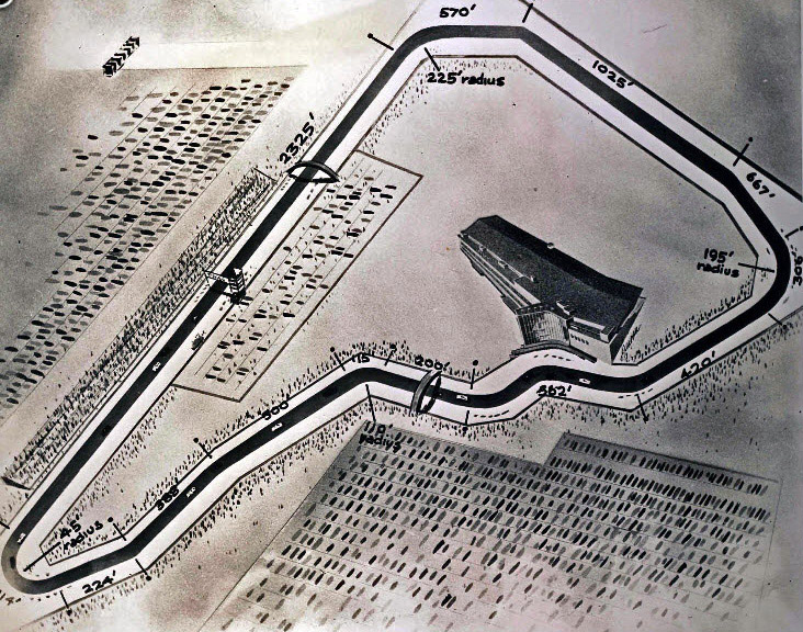
1960 Vanderbilt Cup Race
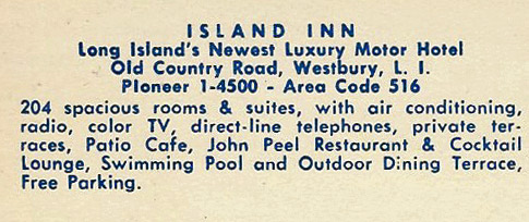
Island Inn Motor Hotel
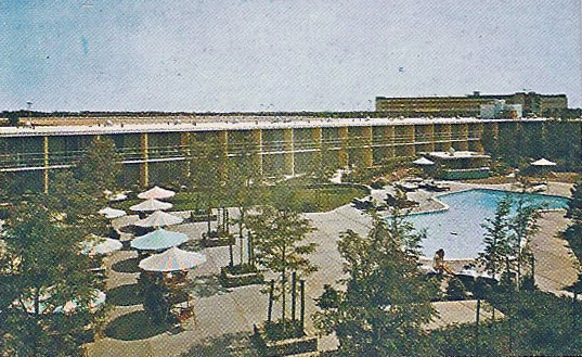
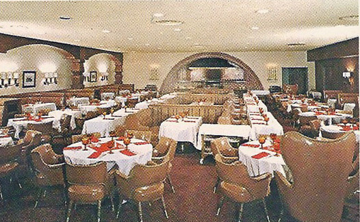
Remember the John Peel Room?
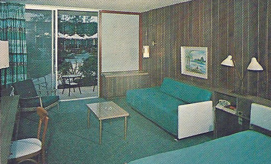
One of the 204 "spacious rooms and suites" of the Island Inn.
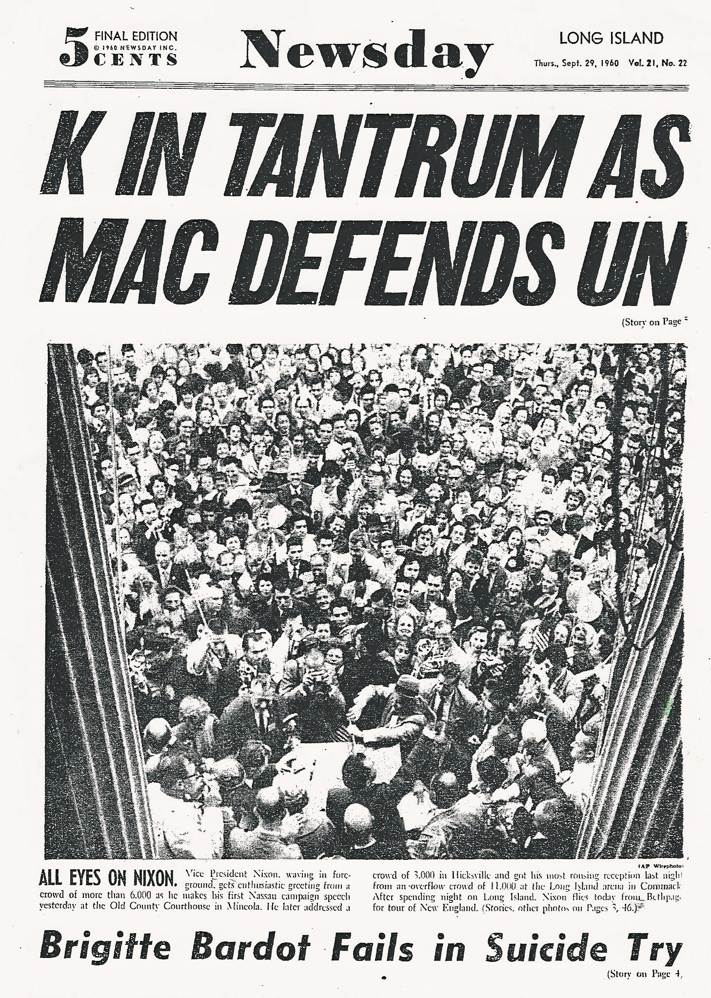
Vice President Nixon's visit to Long Island on September 28, 1960.

Kleiner's Korner (Submitted by Art Kleiner)
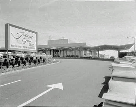
Island Inn Motor Hotel-1960
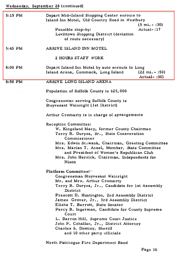
The "Strictly Confidential Itinerary" of Vice-President Richard Nixon (September 25-October 1, 1960). Courtesy of the Nixon Library.
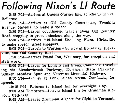
Newsday, September 28, 1960
My father likely saw this article in Newsday and thought it would be fun to meet Vice President Nixon.
Roosevelt Field-November 2, 1960 (Courtesy of Bob Hoffman)
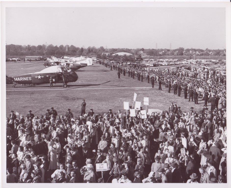
Roosevlet Field looking north on November 2, 1960. Note: The large crowd on the bottom of the aerial.
Six days before the election, Richard Nixon returned to campaign on Long Island with President Dwight Eisenhower, Governor Nelson Rockefeller and Vice President candidate Henry Cabot Lodge.
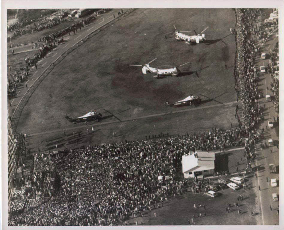
The helicopters and security for President Eisenhower and Vice President Nixon
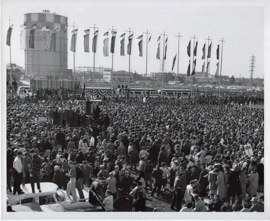
Vice President Richard Nixon's Roosevelt Field speech
I remember that huge gas tank!
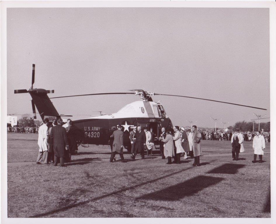
President Eisenhower arriving at Roosevelt Field.
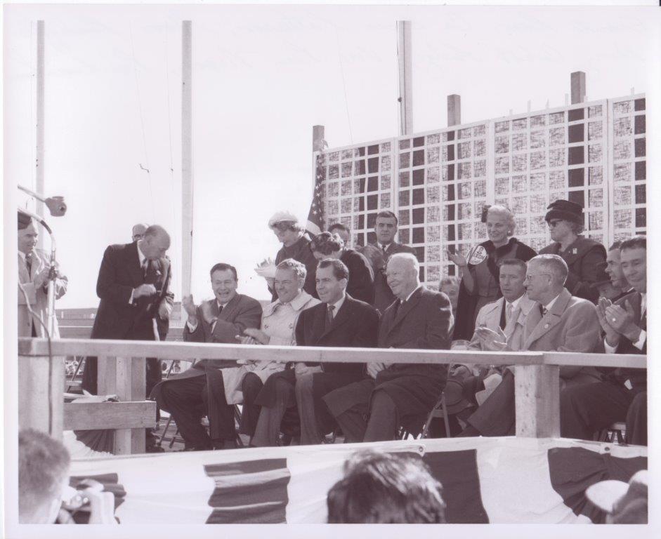
A historic Long Island photo: From left to right: County Executive A. Holly Patterson, Governor Nelson Rockefeller, Ambassador Henry Cabot Lodge, Vice President Nixon and President Dwight Eisenhower
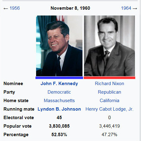
President John Kennedy ended up winning New York State by 5%. Find out the national chaos that would have happened if Nixon had beaten Kennedy in New York.


Comments
Great Pix. Roosevelt Field Mall. Looking east. The Meadowbrook Parkway is just behind the mall.
I believe it’s the Roosevelt field mall complex along side OCR, zeckendorf blvd and merchants concourse. All leading towards the source mall plot. I believe the Meadow Brook parkway is running parallel.
This weeks aerial is of Roosvelt Feild looking east with remnants of the old hangers on the left bordered by Old Country Rd ,Glen Cove Rd and Stewart Ave . You can also see Roosevelt Raceway ,The Island Inn and Arma.You can also see Macy’s on the right of the photo and Gimbals being erected on the left. St Brigids spire is also in the photo.The Vanderbuilt Cup Races were at at Roosvelt Raceway in 1936 &1937;.In bottom of the aerial you can see remnants of the Motor Parkway cross Glen Cove Rd running in the back of Roosvelt Feild.There are 3 hangers remaking out of 5 .The amusement park Spaceland occupied the hanger closest to the Meadowbrook Parkway as seen in the Photo from 1958 to 1960. I snuck in there when it closed when I was a kid.The photo is about 1954/1955 because Gimbals is being built on the north side of Roosevelt Feild and that opened in 1956. The Island Inn (were Howard Shook V.P. Nixons hand)is seen in the 3rd frame on Old Country Rd.just east of Arma or Amercan Machine and Foundry were on Nov. 2 1960 Vice President Nixon visited Roosvelt Feild Mall .
...love these historic photos! Thanks.
Rich
From Holly Lapinel:
I would say
the front is from Clinton Street, LI motor parkway on the lower right heading west
the parking and ring access Roosevelt Field
the back upper right corner of the picture is Roosevelt Raceway
the back upper left corner of the picture is the hangers that were turned into the Cradle of Aviation, LI Museum that houses the Nunley’s Carousel. I see three hangers but the doors look like they are on the west side of the buildings, rather than the south side.
Mitchelll Field was part of the College, WHPC which is still the call letters of the NCC Nassau Community College radio station. The original name was Wonderful Hempstead Plains College ( this is the name sake of Hempstead Plains Vintage Car Club).
A lot of the open space is remnants of Hempstead Plains and thanks to the work of Betsy Gulotta (Emeritus Biology Professor of NCC) the grounds are maintained and historical flowers are being repopulated by the “Friends of Hempstead Plains”
I don’t know the hotel but would guess the Marriott of Uniondate.
Links to VCR is the Motor Parkway, and the LI Motor Parkway was at the right edge of the Ring access road before what was to become where Stewart Ave.
Take care.
You’re over Garden City, looking due-(LI)-west across Avalon Road, Clinton Road, and an early incarnation of the Ring Road at Roosevelt Field Shopping Center, with Macy’s the “white” building at right and MeadowBook Parkway beyond and “several” (HA!) of Roosevelt Field’s old hangars on Old Country Road at left and Rosevelt Raceway (trotting track) at right. The LIMP RoW runs diagonally from bottom center towards upper right between Avalon Road and Pell Terrace (off image to the right) and reappears in the far right distance. The odd, thin line running from lower left across the Ring Road and into the Center to a terminal and looping around to the right and back was a commuter bus line my daughters used to get to the Center. The big building on OCR beyond the hangars was American-Bosch/ARMA back then (later AVIS HQ) and had its own LIRR rail spur track coming up from below Stewart Avenue. VCR’s were run all over the area, notably on Ellison Avenue at middle far left and the ‘36-‘37 I. George V. recreations were run in the big white square beyond ARMA, where traces of the course can be seen. Like Rich, love these pix! Don’t need no impossible bonus. :·) Sam, III
Great Image! OK, here I go:
*Location/Orientation: Viewing east. Overseeing Roosevelt Field Shopping Center, Roosevelt Raceway, and Eisenhower Park. E Garden City/Westbury.
*Aerial link to VCR’s: The 1936, 1937, and 1960 Vanderbilt Cup Races were held at the Roosevelt Raceway ( George Washington Vanderbilt III, George Preston Marshall, and Edward Rickenbacker combined funds to build the Roosevelt Raceway to revive the Vanderbilt Cup. George Robertson ( 1908 VCR winner ) oversaw the construction ).
*Aerial link to LIMP: In this image ( upper right ), the LIMP ROW is just S/O the Meadowbrook Pkwy; W/O Ave C. E/O Ave C, the LIMP ROW is just N/O then Linwood Ave ( Mitchell Gardens Military Housing Community ). COVANTA ( Waste Management Facility ) and the PSEG LI substation ( Mitchell Gardens ) now occupies the site.
*# of Airplane Hangars evident: I see 3 S/W of Old Country Rd/East Gate Blvd.
*Amusement Park in Aerial: There looks to be an attraction ( Skating Rink? ) just E/O Grand Union in the shopping center.
*Aerial Date/Rationale: I’m guessing 1961. There’s a building under construction just E/O the Amusement attraction ( This building to be Gimbel’s, I believe. Gimbel’s was open for business in 1962 ).
*Motel where Mr. Kroplick shook hands with Mr. Nixon: The Island Inn Motor Hotel, S/E corner of Old Country Rd/Zeckendorf Blvd. I searched thru some Historic Newspapers, but no luck. I’m confident that some of you will find/submit documentation of this encounter. Good Luck, BDM
Identify the location and orientation of the aerial. Looking east over Roosevelt Field, Roosevelt Raceway, the Meadowbrook Parkway and Salisbury Park.
Link the aerial to the Vanderbilt Cup Races. Races were run there in 1937 and 1937.
Link the aerial to the Long Island Motor Parkway. Parkway ran on the southern border of Roosevelt Field along today’s South Street.
Identify a remaining section of the Motor Parkway. Along South Street.
How many airplane hangars are in the aerial? Three
Where is there an amusement park in the aerial? The northern part of the mall (to the left in the picture) shows a few rides. Also, Spaceland occupied Hanger 16 in the 60s.
What was the date of the aerial? Provide a rationale. 1956/1957, Roosevelt Field completed. Meadowbrook Parkway completed. Howard’s handshaking date of a few years later (see next answer).
A few years after this aerial was taken, identify the famous motel in the photo where Howard Kroplick shook the hand of Richard Nixon. Impossible bonus question: What date did this occur? The answer is available online!
Island Inn in Westbury, Sept. 28, 1960.
Bonus Bonus Question: What was on the menu for Richard Nixon?
Id say the photo was from the mid tfifties of Roosevvelt field looking East. Note the RR bridge that is still up over the meadowbrook just south of that cloverleaf. Didnt murry the K use one of those three hangers as a discotec in the sixties?
The photo is looking east from a position approximately over Clinton Road in Garden City with the fairly new Roosevelt Field Mall in the center. It encompasses the former sites of the 1937, 1937, and 1960 Vanderbilt Cup Races. I believe there is a small section of LIMP in the upper right corner near where the Meadowbrook Lodge had been. I think I see 4 remaining hangars from the Roosevelt / Curtiss Field days. It looks like Gimbel’s is still under construction so I think the photo dates from late 1961 or 1962. No idea on the amusement park or motel.
Identify the location and orientation of the aerial.
-Roosevelt Field Mall looking East.
Link the aerial to the Vanderbilt Cup Races.
Roosevelt raceway in the background, location for the 1936/37 Vanderbilt Cup Races
Link the aerial to the Long Island Motor Parkway.
Identify a remaining section of the Motor Parkway.
The LIMP ran along the right edge of the photo where Ring Rd is.
How many airplane hangars are in the aerial?
4
Where is there an amusement park in the aerial?
Possibly at the mall?
What was the date of the aerial? Provide a rationale.
Judging by the recently-built Roosevelt Raceway grandstand, I’ll guess 1958
A few years after this aerial was taken, identify the famous motel in the photo where Howard Kroplick shook the hand of Richard Nixon. Impossible bonus question: What date did this occur? The answer is available online!
Don’t know the motel, but will guess sometime in October 1972 while here for the Republican rally at the Nassau Coliseum.
The only comment I can make is that the first photo looks like the Roosevelt Field shopping center in its early stages, This is before it was enclosed.
Rog
Roosevelt Field looking east
Top right is Roosevelt Raceway, site of 1936 Vanderbilt Cup race
Old Country Rd. On left vertical with 3 old Roosevelt hangars
St. Brigid RC church steeple at top left
Salisbury Links across top
Meadowbrook Parkway snaking through in center
Year: 1960
The Island Inn on Old Country Road
Don’t count me out yet, Howard. I may have the answer to the Bonus Question!
Did a FREE SEARCH ( Abstract ) on the NEWSDAY website. I first searched “Kroplick” between 1960 to 1970. Only 1 Article came up…...Family Doctors Defended: They Do Their Duty Pg. 18 July 29 1961. I then searched “Richard M Nixon” along with the July date, and the same article came up. So my answer to the Bonus Question is 7/29/1961. Knowing this, I’ll need to change my previous guess concerning the Aerials Date/Rationale. My guess now is 1958. I read that the Island Inn officially opened for business in 1960. The Inn is clearly seen in the aerial, but still in the building stages I guess. And what’s to become Gimbels looks to be in the early phases of construction. 1958 seems like a safe guess for the Aerial. I feel “complete” now, even if my answers to this Mystery Foto aren’t 100%.
This is a nice aerial photo of the new Roosevelt Field Mall. The photo is taken facing east towards Garden City, Carle Place and Westbury.
You can observe the remains of the old Roosevelt auto raceway which held the 1936-37 Vanderbilt cup races.
The LI motor parkway remnant section can be observed just east of the current Merchants Concourse (present location of Covanta and Tracom)
The 3 hangers can be seen on the S/S of Old Country Rd just east of the Meadowbrook Parkway. The amusement park is on the north central section of the mall next to the future Gimbels. The apparently unfinished Island Inn with the famous John Peel Room can also be seen just south of Old Country Rd By Zeckendorf Blvd.
The newly completed stands for the Roosevelt Raceway harness track can also be observed.
I would date the photo was taken in 1957. The Macy’s department store opened in august of 1956 and the raceway stands were completed in 1957.
I’m not surprised at all that Art Kleiner would somehow find out the actual date, good going; Art.
Don’t know what to make of my finding in the NEWSDAY archives ( my 2nd comment ). If I was at the local library researching this, any past articles are freely available, unlike my home computer. Oh well, thought I was onto something.
_____________________________________________
From Howard Kroplick
The historic Newsday database are usually available online by going to your library’s Internet database.
Whoops! Completely forgot the skating rink and the old Island Inn - best known “in the day” for “hot and cold running maids” (there was a huge scandal of some sort there - errant housewives turning tricks, as I recall). Yes, Steve, Murray the K did just that. We all missed the segments of LIMP RoW through Salisbury (now Eisenhower) Park and along adjacent Salisbury Park Drive (partly restored). I also forgot the 1960 race (mea culpa) - I vas dere, Cholly, and snuck my XK-120M Jag onto the course and did a lap after the race had ended before being chased off. What a great thread - thanks, Howard! Sam, III