Motor Parkway Survey Bookmap C: The Western Terminus in Fresh Meadows, Queens
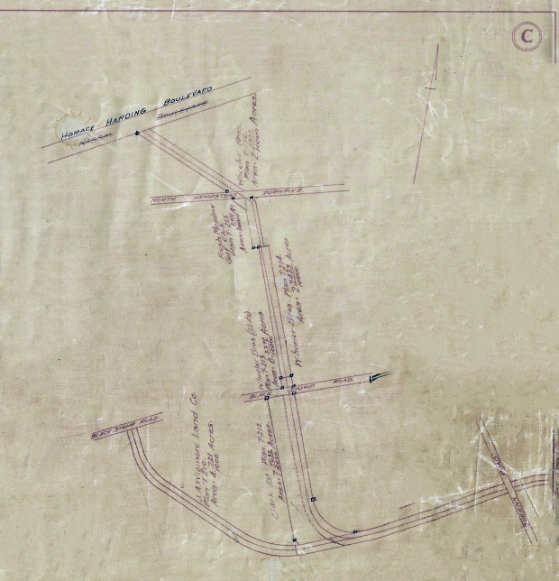
This is the first of a new series documenting the newly renamed 1910 Motor Parkway Survey "Bookmap". It highlights the first page of the 22-page canvas document: Map C showing the Western Terminus from Nassau Boulevard (Horace Harding Boulevard) to Queens Road (Hollis Hills Terrace).
The Motor Parkway Survey Bookmap (1910)
The Motor Parkway Survey Bookmap consists of 22 canvas pages (each 17 1/2" x 12"). Unfolded, the Bookmap measures 32 feet by 1 foot The original canvas pages are marked from 1 to 18 with surveys from Lakeville Road, Lake Success to Lake Ronkonkoma. Three more canvas pages (A, B, and C) were added documenting the Motor Parkway extension west from Lakeville Road to Nassau Boulevard, Fresh Meadows from 1910 to 1928. There is also an Index page to find properties and roads.
Although the original canvas pages of the Bookmap are not dated, it was likely created in 1910 based on the Lakeville Road western terminus and the identification of the Petit Trianon as the L.I.M.P. Inn. The original surveyor was probably Arthur Archibald, who created many of the Motor Parkway surveys in the Barrett, Bonacci collection. As noted by Al Velocci, the term bookmap was used by the Motor Parkway's general manager A.R. Pardington to describe the document.
From 1927 to 1930, my copy of the Motor Parkway Survey Bookmap, purchased from the survey firm on Barrett, Bonacci and Van Weele in 2009, was used to indicate the location of survey monuments and changes in the Motor Parkway right-of-way including the Commack Etension (Spur). These notations were hand-written in ink.
Be Safe, Stay Home,
Howard Kroplick
Map C Close-ups
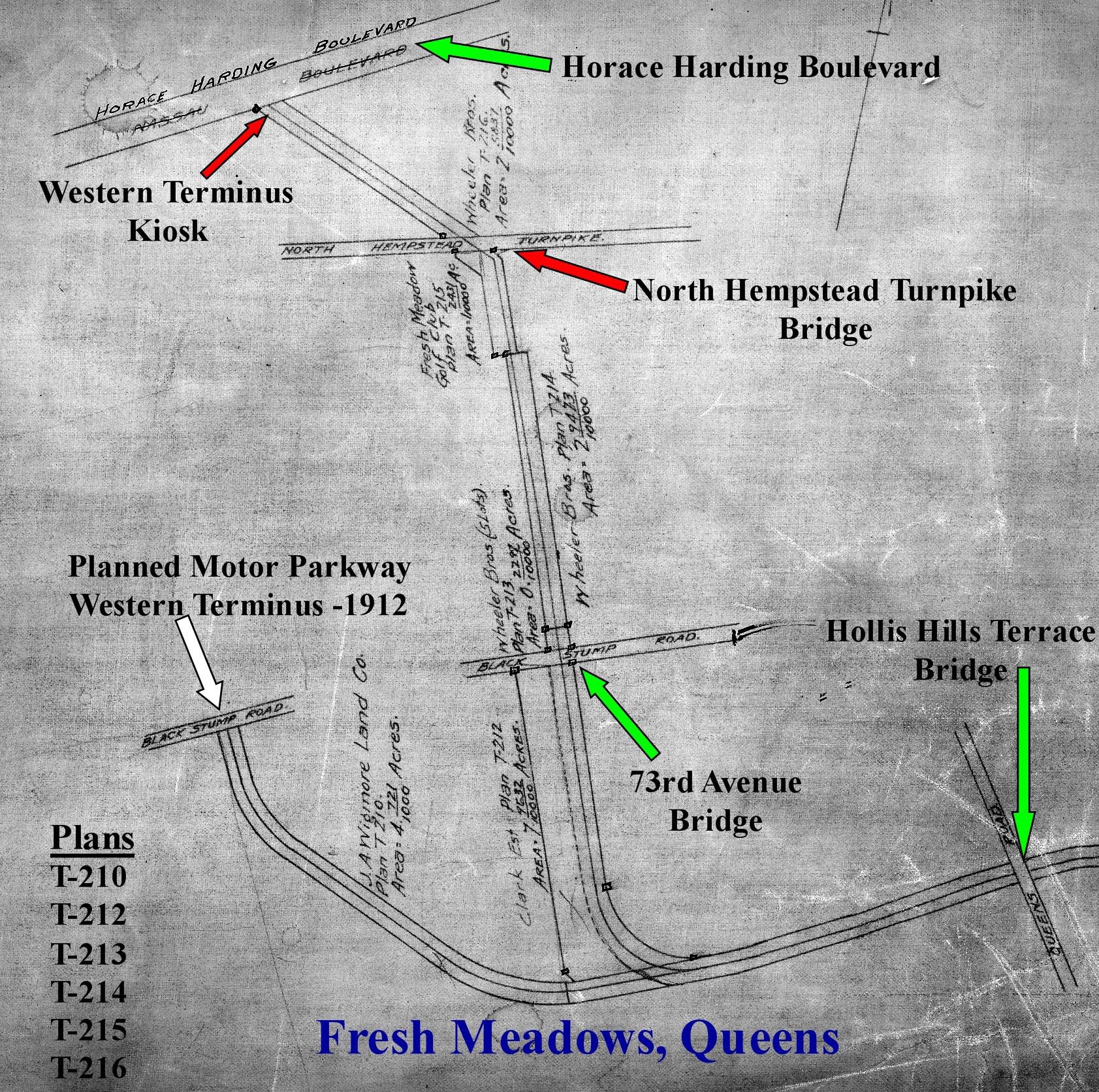
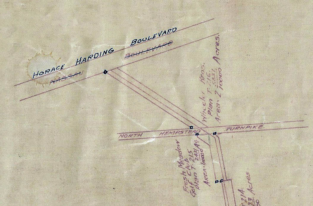
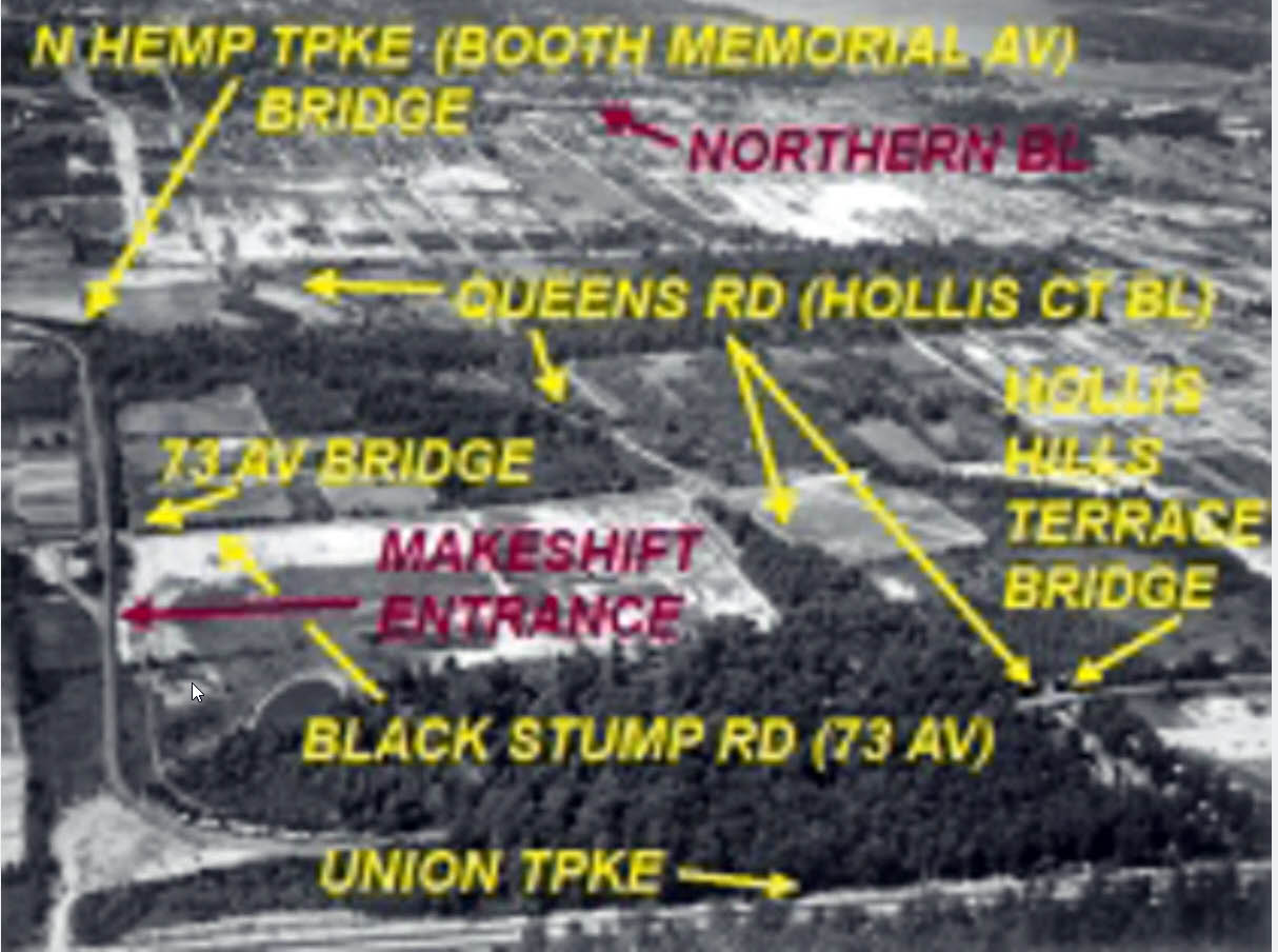
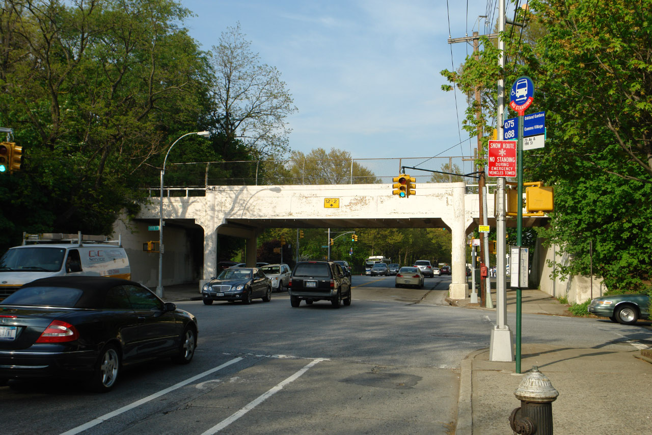
Nassau Boulevard was crossed out by the survey firm when the road was renamed Horace Harding Boulevard.
The small squares indicate survey monuments.
Note: The Motor ParkwayInc. purchased property from the Fresh Meadow Golf Club.
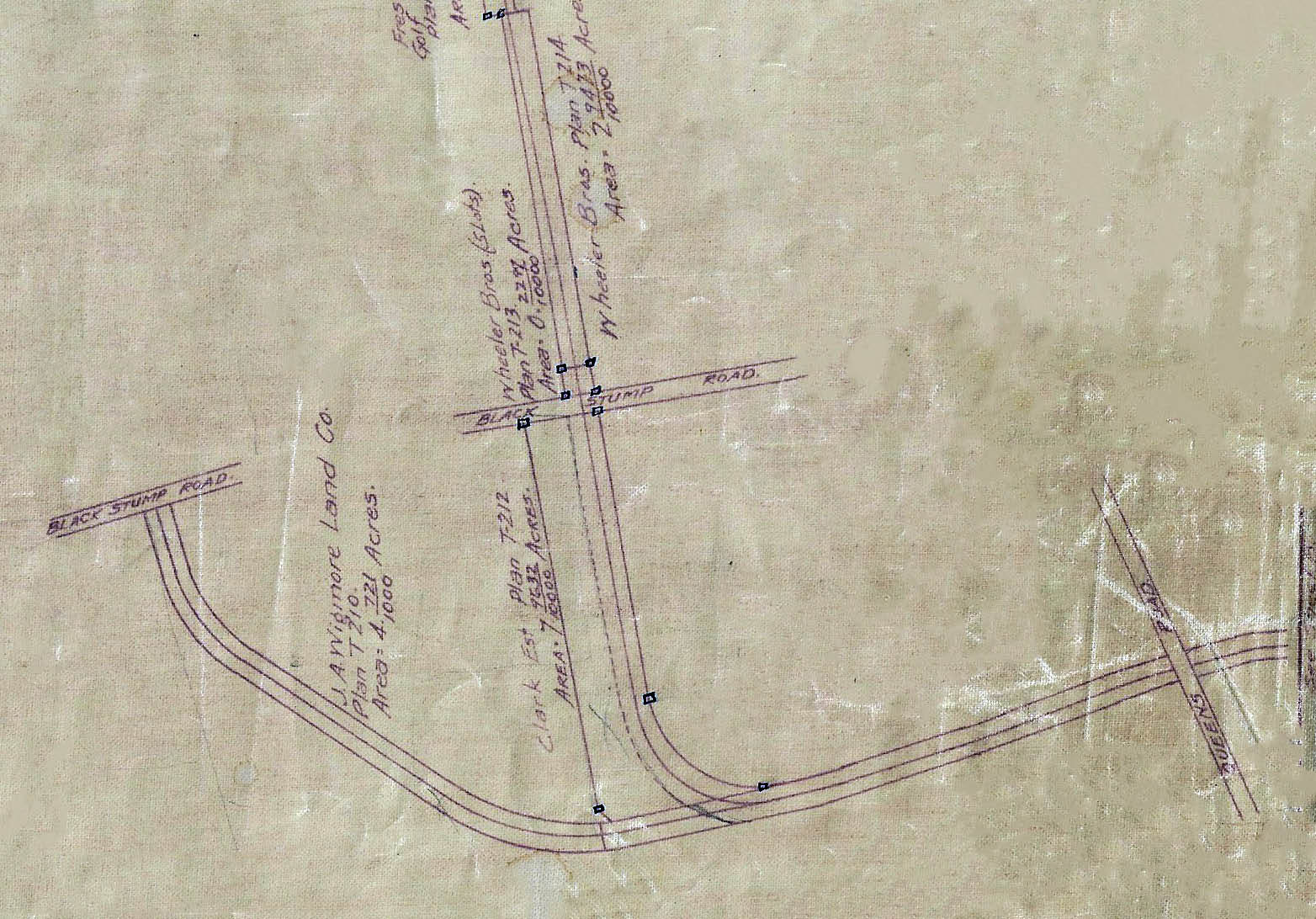
Black Stump Road was renamed 73rd Avenue and Queens Road became Hollis Hills Terrace.
Note: The originally 1912 planned Westerm Terminus ending at Black Stump Road can be seen on this survey (far left) before it was changed to extend to Nassau Boulevard, the most heavily traveled Queens road in the 1920s.
See my favorite co-author Al Velocci's below comments.
The Western Terminus
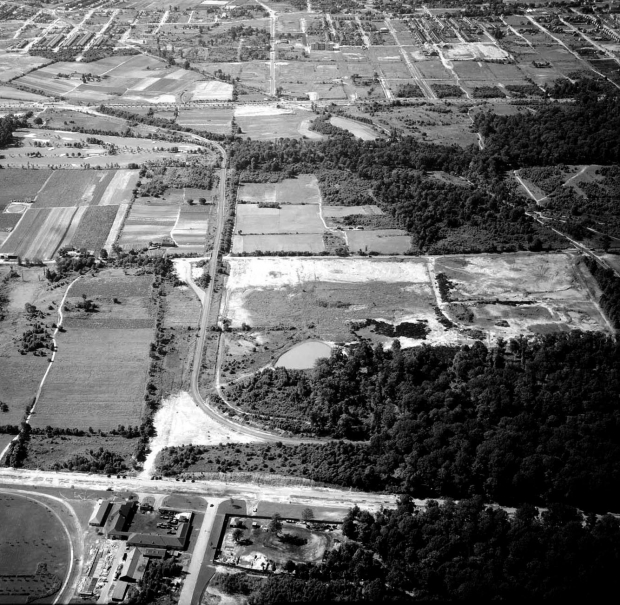
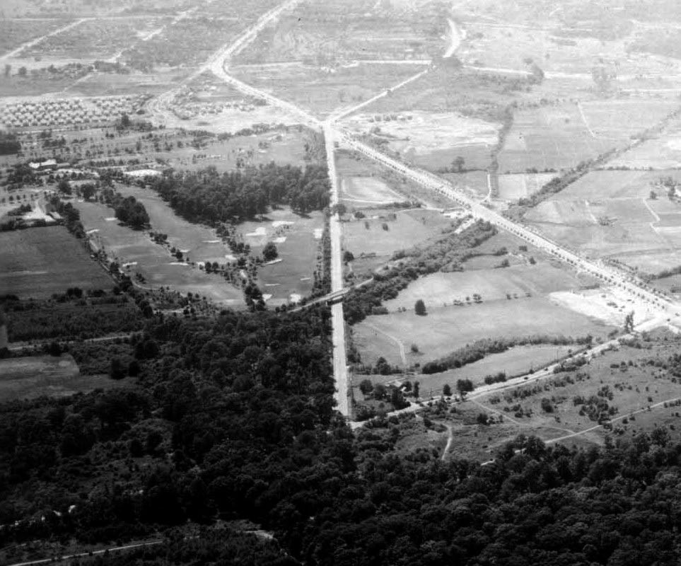
1938 Aerial
June 24, 1938
Courtesy of Frank Femenias
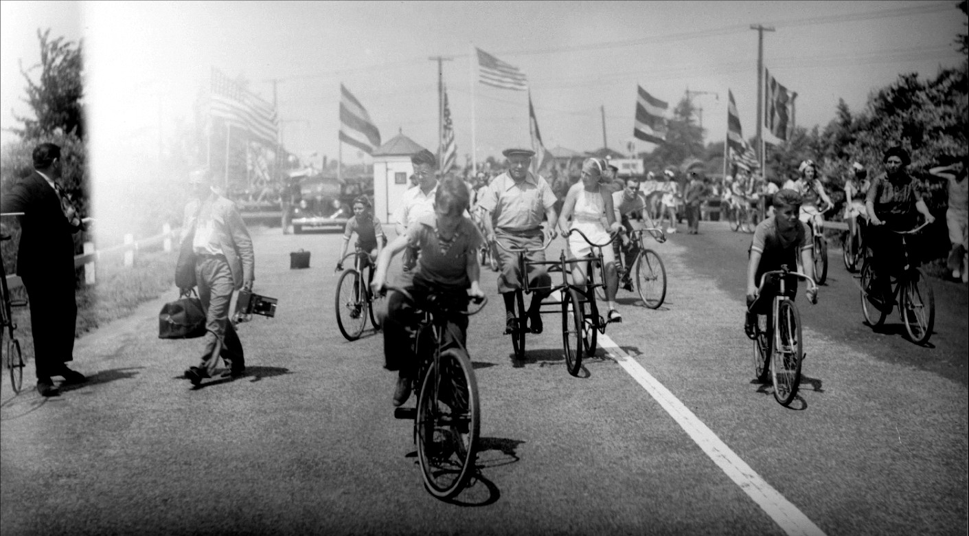
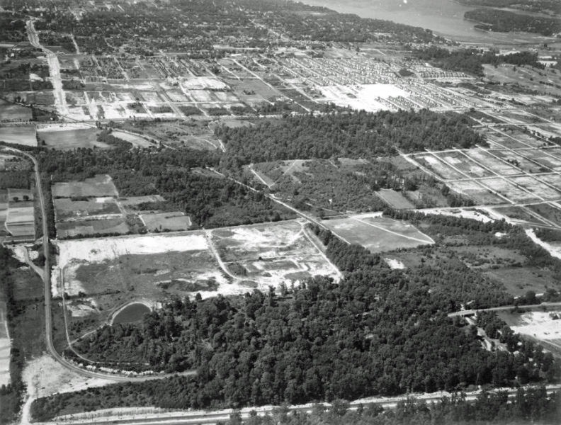
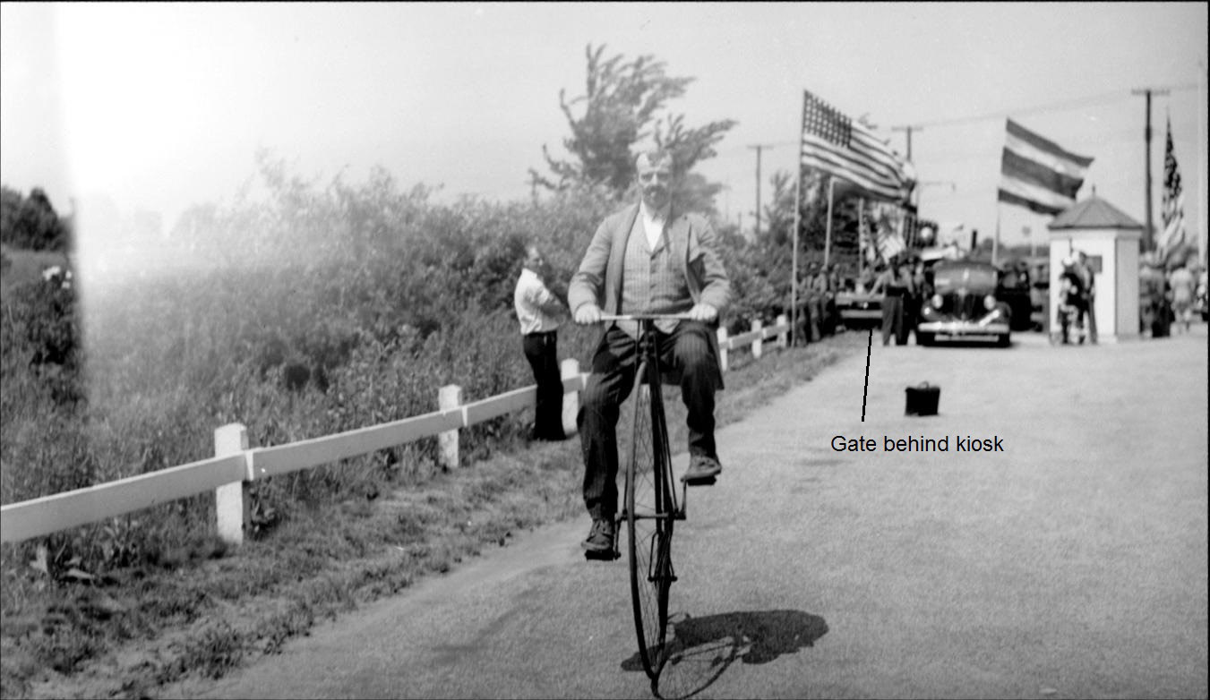
The Opening of the Motor Parkway Bike Path at the Western Terminus- July 9, 1938
North Hempstead Turnpike Motor Parkway Bridge
The Fresh Meadows Golf Club and the North Hempstead Turnpike Motor Parkway Bridge
June 2, 1939
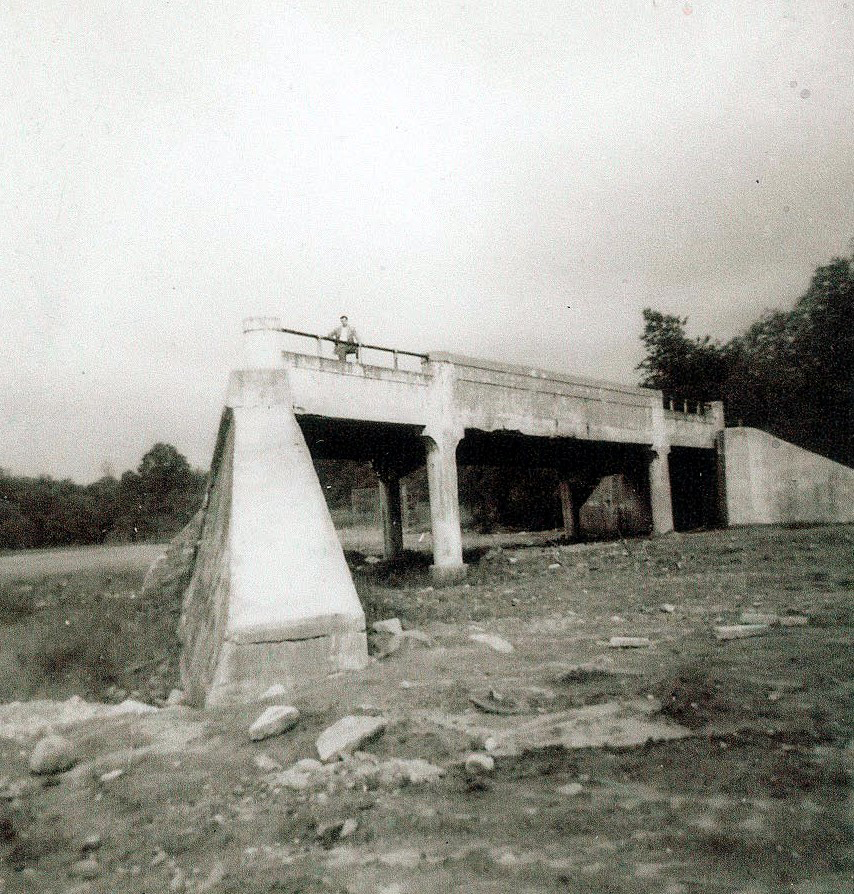
North Hempstead Turnpike Motor Parkway Bridge
73rd Avenue Motor Parkway Bridge
Hollis Hill Terrace Bridge
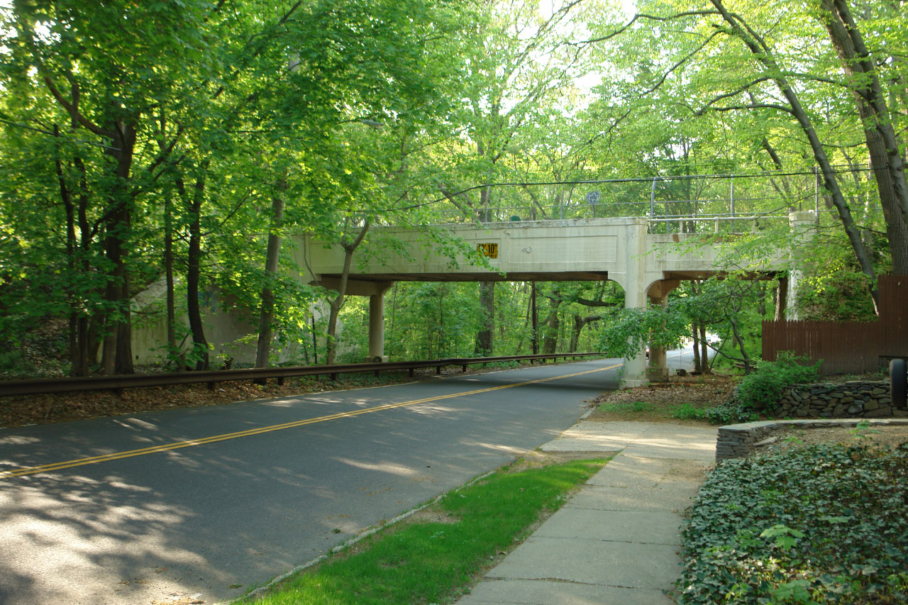
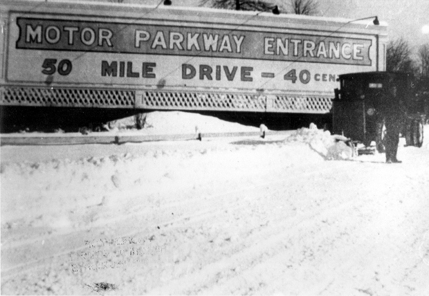
Still beautiful after all these years.


Comments
Wonderful material, as always. I’ve inquired for many months as to why can’t the images be larger, via the links, as many are of no value to really see, especially the maps)? No response. Do others concur with this issue? Best, Steve
__________________________________________________
Howard Kroplick
Steve, thanks for the comment. The website was built 12 years ago and is currently being upgraded to a new platform. Hopefully, it will increase the size of the images.
nice job
The notes at the top indicated that Queens Rd. was renamed to Hollis Hills Terrace. However, it was renamed Hollis Ct. Blvd. first, and then became Hollis Hills Terrace sometime after the LIE cut off Hollis Ct. Blvd; possibly when the Cleraview went through in 1964. I grew up in a newly built home (1953) on 199th St and 51st Ave. The future site of my boyhood home can be seen on two of the maps. PS 162, where I went to Public School, opened in 1936 and can be seen in the photos. It is at 53rd Ave and 201st St. Before the LIE was constructed, the intersections of Horace Harding Blvd., Francis Lewis Blvd. (which was subsequently extended south to Hillside Ave. and opened just after the War) and Hollis Ct. Blvd. was a nightmare.
Howard, I’m sure anyone with even just a passing interest in the Motor Parkway appreciates the posting of these maps. Particularly interesting on this one is the terminus planned in 1912. At the time Black Stump Rd. in this part of Queens, was the best connection for eastbound automobile traffic. When the decision was made to extend the Parkway westward from Rocky Hill Rd., things had changed. The plan now was to have the western terminus of the Parkway at the new Nassau Blvd. The problem with taking the Parkway north from the original Black Stump Rd. terminus was the Fresh Meadow Golf Club on the north side of Black Stump Rd. Vanderbilt had Kienzle write the club to inquire about the possibility of taking the Parkway north thru the golf course to reach the proposed Nassau Blvd. You can guess what the club’s response was. It was at this time the decision was made to take the Parkway northward east of today’s 199th St. The Parkway was fortunate in that there were only two parties to deal with in acquiring the ROW to reach Nassau Blvd. The plan at first was to take the ROW straight north. Then the Parkway discovered it would have to build a bridge over the old but still existing Central Railroad ROW before they could get to Nassau Blvd. To avoid this very expensive situation the Parkway approached the Fresh Meadow Club about the possibility of acquiring a small piece in the northwest corner of the course. This would allow the Parkway to angle the ROW and the North Hempstead Tpke. bridge north westward to Nassau Blvd. without crossing over the Central Railroad ROW. Fresh Meadows agreed to do so but it cost the Parkway dearly, but still much cheaper than building another bridge. The Parkway acquired an acre paying $10,000 for the parcel. The cost to purchase the other properties for the new ROW was $3500 an acre. The Parkway also had to rebuild a green for the golf club which cost the Parkway another $1000 and paint the south side of the North Hempstead Tpke. bridge white and on a regular basis. Again, thank for posting the maps.
Broken record! I’ve never found those missing photos showing the RoW extending west to 193rd or so but I clearly remember them showing cars on an extra lane on the south side of Nassau/HH Blvd. between Peck and 193rd/194th. ??? Sam, III
Booth Memorial Avenue was formerly known as North Hempstead Turnpike? Interesting. Parts of NY 25A are now known as North Hempstead Turnpike. Today there is no trace of the old North Hempstead Turnpike south and east of Horace Harding Blvd./the LIE.
The Frank Femenias call outs of the aerial photo of June 24 1938 did not expand after the click on like the other’s photo were able to do? why?
_______________________________
Howard Kroplick
Mark, give it another try.
Should have been the “northeast corner of the course”.
Al, Yes, it was North Hempstead Turnpike previously and it’s eastern terminus was at Hollis Court Blvd. prior to the development of Cunningham Park and the coming of the “Cross Island Boulevard”. Ir was around this time the name was changes to Booth Memorial Avenue.
To Al Prete’s comment-
The North Hempstead Tpke that is NY25A is unrelated to the NHT of this story. “Northern Blvd” has had many names, but by 1900, the Queens stretch was mostly known as Broadway, with the name changing to NHT at the Nassau border. That one part you referenced kept this old name.
The NHT in this post extended from the Strongs Causeway area to Queens Road (Hollis Ct. Blvd.) This NHT extended a road, known variously as Ireland/Ireland Mill/Mill Road, that had ended at/near Fresh Meadow Lane to Queens Road (Hollis Ct. Blvd). This NHT was intended to bypass the late 19th century congestion in Flushing on roads that form the modern Northern Blvd. Ironically, that was Horace Harding’s intent, too, in proposing Nassau Blvd., which made this NHT obsolete for long-distance travellers.
The Fresh Meadows development destroyed much of the eastern portion of NHT, but some roadbed, including its eastern terminus still exists. That roadbed is in the woods west of the Clearview Expwy, so, Al there’s still a trace left!
Both roads shared the name NHT, which referred to the long-distance destination the Town of North Hempstead, as I suspect Howard or Al V. have explained elsewhere.
The isolated segment of Hollis Ct. Blvd, between Clearview/73rd and the GCP, was renamed Hollis Hills Terrace to avoid confusion for visitors looking for addresses along this stretch of road in the pre-Google Maps era. (Some people would travel down Hollis Ct. Blvd from the north, only to see it “end” at LIE before encountering the addresses they sought.)
About Al V.‘s 11:21 AM comment: the NHT renaming had nothing to do with the coming of “Cross Island Blvd.” Part of NHT was renamed Booth Memorial in conjunction of an anniversary celebration that honored the eponym medical center, which opened in 1957. However, much of the street remained NHT which doubly confused everyone, including us 70s graduates of Francis Lewis HS, located at the corner of Utopia Pkwy & NHT. About 30 years ago, sanity took over, and the entire extant road to the LIE was renamed Booth Memorial—only to see the medical center renamed in 1993.
So, today, there is no Booth Memorial on Booth Memorial Ave and FLHS is not, and never has been, on Francis Lewis Blvd (once Cross Island Blvd.). Don’t you love Queens streets!
The “other” No. Hemp. Tpke LIVES further east! The former tiny Muttontown Unitarian Universalist Fellowship on the south side of No. Blvd. just west of Chelsea and 107 had a legal street address of 6080 North Hempstead Turnpike.
Hey David, Thanks for adding some clarity to the North Hempstead Turnpike/Booth Memorial scenario. When researching the western terminus of the Motor Parkway I found that area very confusing. There was a Hillside Park but then it disappeared. What ever happened to the Creedmoor Parkway? Was that a serious consideration? Was it supposed to located on the Central Railroad ROW ? Some help here, when Harding first proposed the building of Nassau Blvd. , I believe it was in 1924, was the western terminus to be at Fresh Meadow Rd? Again thanks for your input.
Al V.-Borough of Queens proposed the Central RR ROW Creedmoor Parkway in 1930. In 12/1937, Robert Moses proposed his arterial highways project, revealing plans for the CIP, presented as the successor to the other parkway. As CIP construction started in 1939, references to a Creedmoor Pkwy can be dated to the 1930s.
Hillside Park is today’s Cunningham Park N of LIMP and S of 73rd Ave. Moses (again!) was trying to prevent development that would bisect his plan green belt of parks. When he finally acquired undeveloped land S of LIMP and E of FL Blvd and W of Hollis Hills Terrace, he could connect Hillside with Cunningham Parks and form one, very large park. Homes in Hollis Hills Terrace partially intrude on Moses’s park plan. [Later, the LIMP bicycle path to Alley (Pond) Park, was the final link in the interconnected green belt of parks.]
Harding’s proposal was from Queens Blvd to Lakeville Rd., but road was built in discontinuous parts. Reusing 64th Ave (once Avenue B), which ended at FM Lane, allowed the part that included that stretch to be finished earlier.
The partial Belcher Hyde map in the 12/9/2009 post shows NB from NHT to Hollis Ct Blvd unbuilt, but NB parts east and west of that segment already built.
Re Queens street names and numbers, I forgot to add that the late Vince Seyfried, noted Queens and LIRR historian, once did a compendious study of all that. In case anyone is interested, I assume the Queens Hist. Soc. or the Queens (Borough) Public Library would know more about it. Sam, III
David, Al - The Creedmoor Parkway (Freeway) was still being seen as an urgent need as noted in the attached Regional Planning Association’s update produced in 1938. The update noted its use of the Stewart RR, the LIRR and the Motor Parkway. Will be noted in a future post, but thought it might spark some comment’s now.
The rest of the article
Art, throughout the 30s, the RPA advocated express highways (which it called “freeways” starting in 1936). This freeway proposal was an updated version of an earlier proposal that sought the “priceless chance” to use the LIMP ROW for a freeway, even as that ROW was too narrow for a freeway. (In turn, that earlier proposal could be considered an adaptation of the 1930 “parkway” proposal mentioned in a earlier comment.)
My commentary: Using the Central RR ROW had its own complications, so this proposal was more about politics than a practical idea. The proposal reflected an emerging tension between the RPA and Robert Moses. Note the RPA’s list is is dated to 11/1937, one month before Moses’s revealed his plans. Not a coincidence, I suspect.
To return to the original post, RPA’s plans overlooked what was anticipated when the LIMP western terminus was extended in 1924-26: the importance of HHB on E-W through traffic to Long Island. Finishing Item #13 only enhanced that importance.
David, thanks for the info. Yes, I agree the RPA was tangled up in politics with Robert Moses as you note. While reviewing the RPA material I often wonder where Moses fit in - guess we know where he eventually did (and what happened to the RPA proposal regarding the Central RR ROW).
David, Best I can do at this time is that the decision to purchase the new Parkway ROW properties was made sometime after July 29, 1924.
David, The info regarding the sale of properties for the new ROW an be found at Deed Libor 2692, page 379 and Libor 2696, page 255. I FORGOT TO WRITE THE DATES…..... I do know it was after July 29, 1924.
Howard, that section of the unused original Parkway ROW, west of the new ROW was sold back to the Wigmore Co. in 1927.
Art/David, Shortly after the Parkway was taken over by NYC wasn’t there some suggestions that the ROW be used for the coming World’s Fair ? I have a recollection that to help with the expected heavy traffic, the Parkway could be turned into a one way road, westbound in the morning and eastbound later in the day.
Al V., that’s exactly as I remember it playing out - W/B in the AM and E/B PM. Can’t document where I read that, though, but it was a LONG while back, well before MPPS. Sam, III
Al V., the RPA’s “priceless chance” (see earlier comment) referred to forming a freeway from the World’s Fair to Farmingdale using the ROW and was stated in July 1937. I have same memory of one-way traffic plan, but cannot remember source, either.
From Art Kleiner:
Here’s the documentation, as least documenting the suggestion by the NYC Parks Commissioner (Robert Moses?). Will be included in an upcoming post pertaining to the 1938 RPA update from which it is taken.