Femenias’ Findings:Finding Petit Trianon, the Annex & the Petit Trianon’s Lake Stairway Updated 3/12
As a follow-up to Sam and Dave's Excellent "Lost" Motor Parkway Adventure to the Eastern Terminus, expert mapper Frank Femenias has used his overlay skills to help us find the Petit Trianon, the Petit Trianon Annex and the Petit Trianon Stairway to Lake Ronkonkoma.
Below are Frank Femenias' Findings combined with historical images of the target structures.
Enjoy,
Howard Kroplick
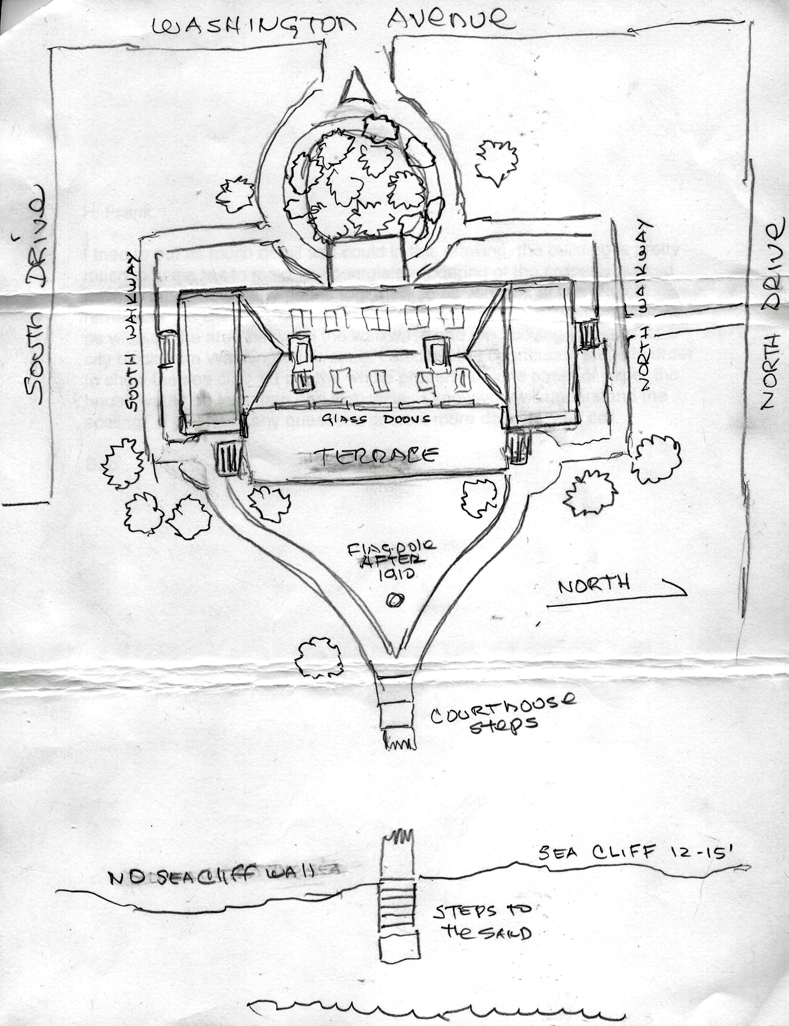
Updated 3/12/2017: Sketch of Petit Trianon by Bob Stefani
Update: 3/12/2017: Submitted by Bob DeStefani
Femenias' Findings (Submitted by Frank Femenias) March 7, 2017
Eastern Terminus
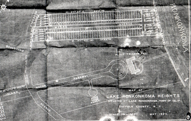
The 1925 schematic of the Eastern Terminus.
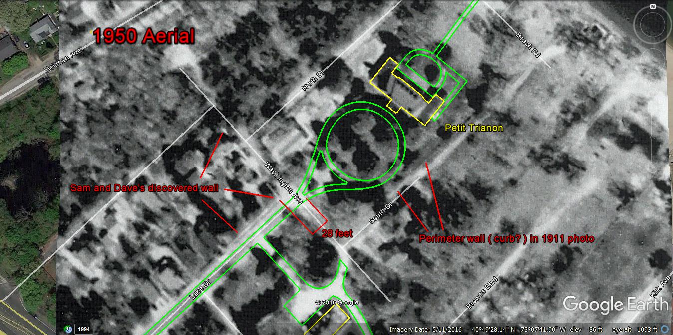
A 1950 aerial of the target structures.
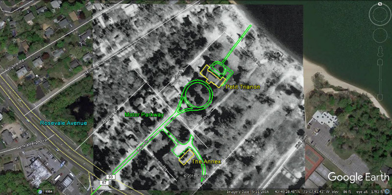
Mapping of the Eastern Terminus versus the 1950 aerial.

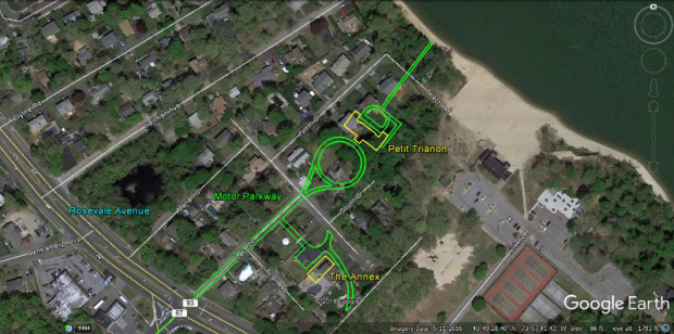
Mapping of the Eastern Terminus' sites versus current Google Earth aerial.
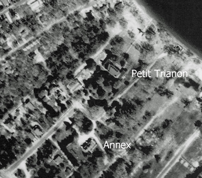
Petit Trianon
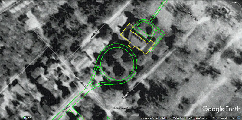
Mapping of Petit Trianon versus the 1950 aerial.
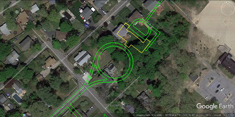
Mapping of Petit Trianon site versus current Google Earth aerial.
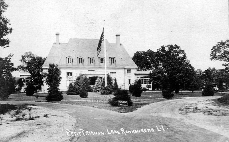
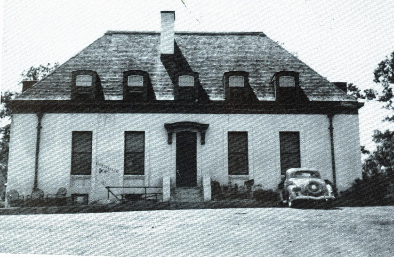
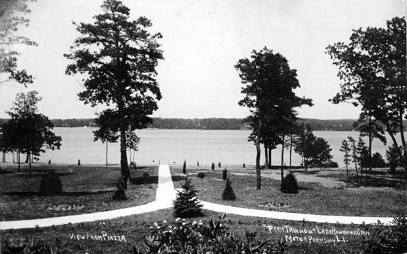
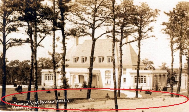
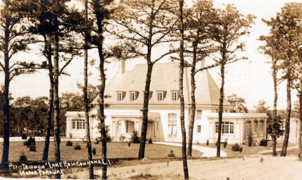
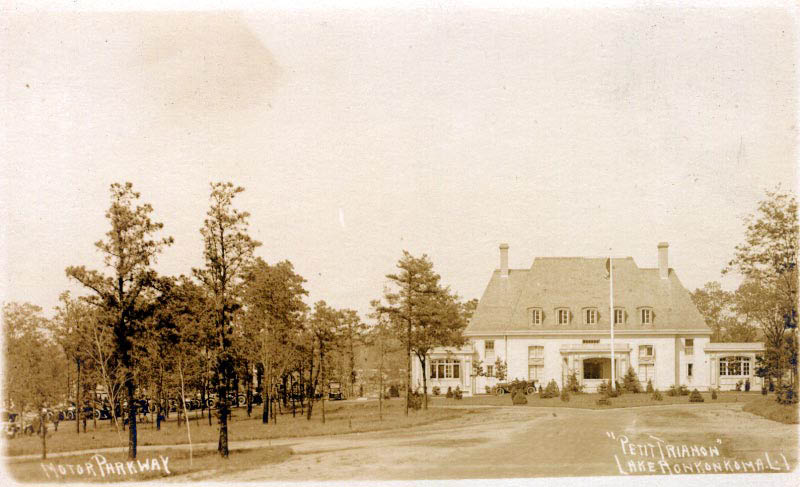
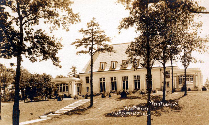
Petit Trianon looking east circa 1912.
Petit Trianon looking west circa 1912.
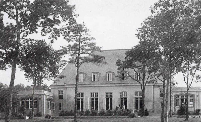
The Petit Trianon Annex
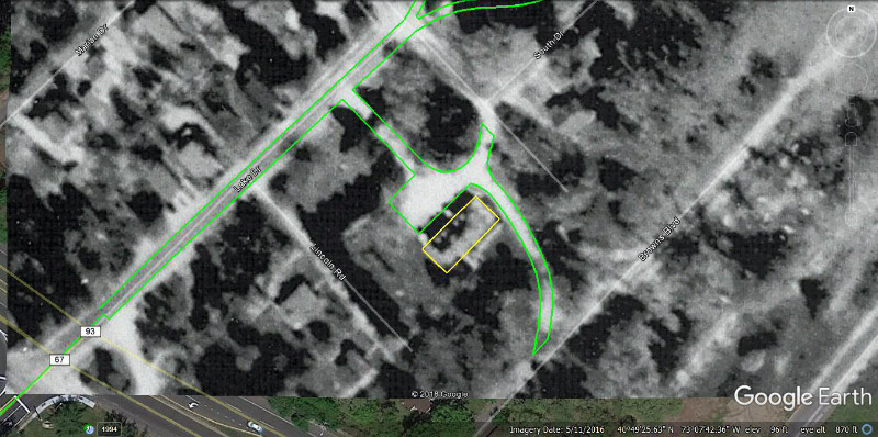
Mapping of the Petit Trianon Annex versus 1950 aerial.
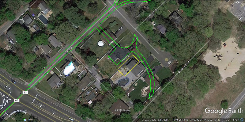
Mapping of the Petit Trianon Annex site versus current Google Earth aerial.
The Petit Trianon Annex building circa 1931
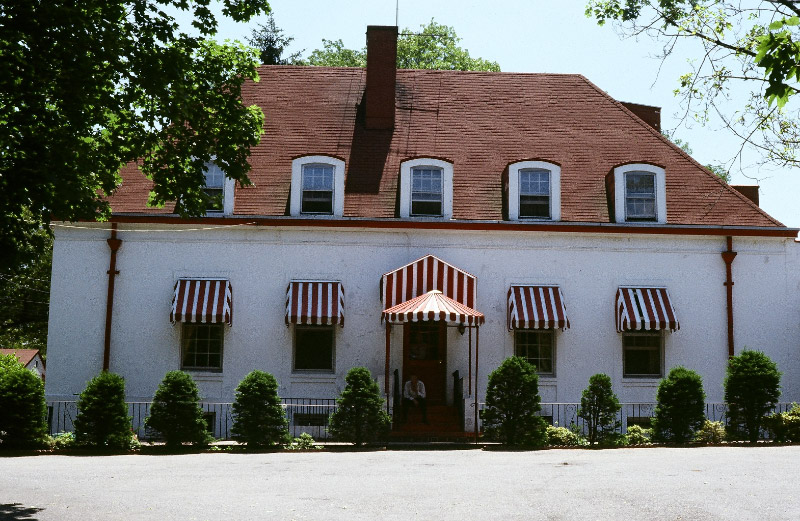
The Petit Trianon Annex building circa 1981. Courtesy of Ron Ridolph.
Petit Trianon's Stairway
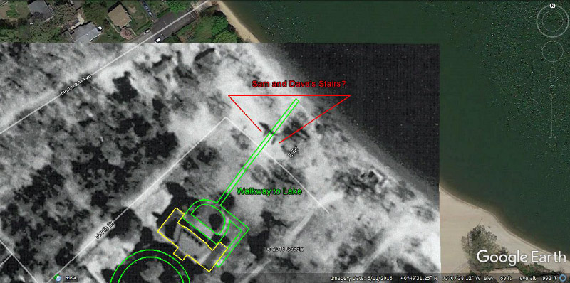
Mapping of the Petit Trianon's Lake Stairway versus 1950 aerial.
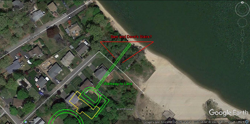
Mapping of the Petit Trianon's Lake Stairway site versus current Google Earth aerial.
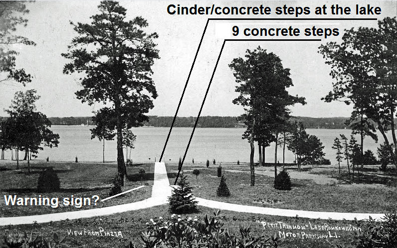
The Petit Trianon Lake Stairway circa 1912
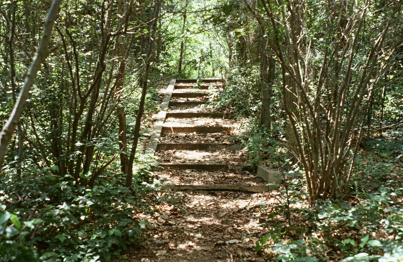
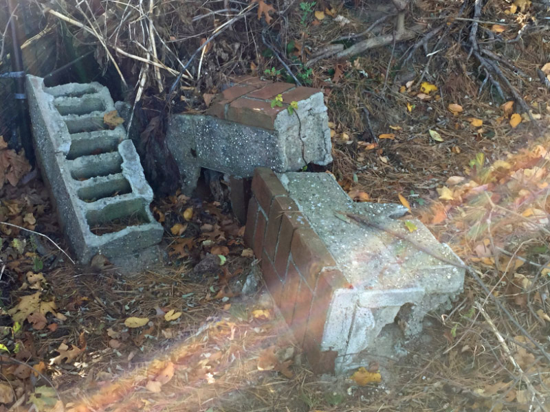
Remnants of the Petit Trianon site in 1981. Courtesy of Ron Ridolph.
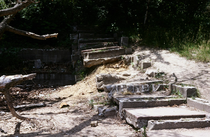
Matches Sam & Dave's photo- 25 years ago!
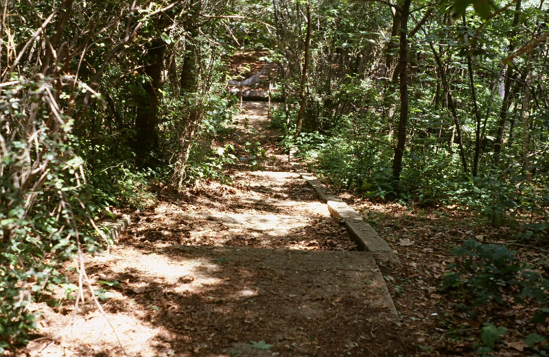
Sam & Dave Russo's 2016 images of remnants of the Petit Trianon's lake stairway.
Update February 2, 2017: Femenias' Findings (Images and comments Submitted by Frank Femenias)
Findings
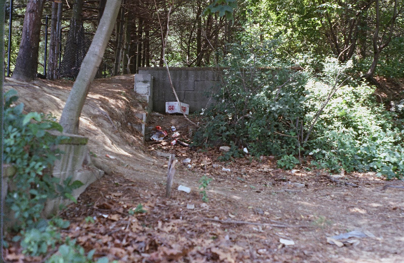
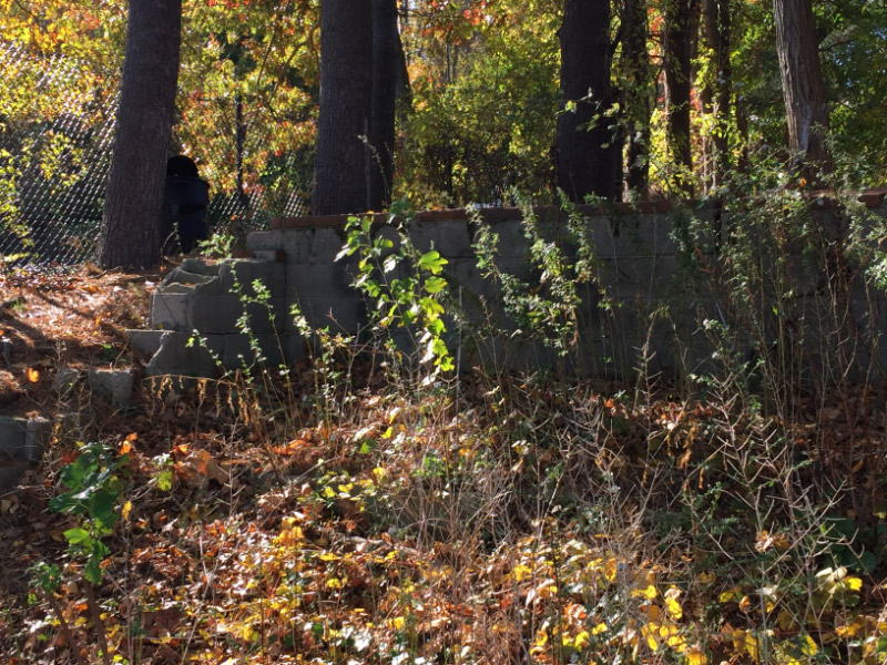
Petit Trianon perimeter wall or curb on South Drive.
Petit Trianon perimeter wall on South Drive
Sam and Dave's missing wall.
The mysterious rear steps circa 1911.
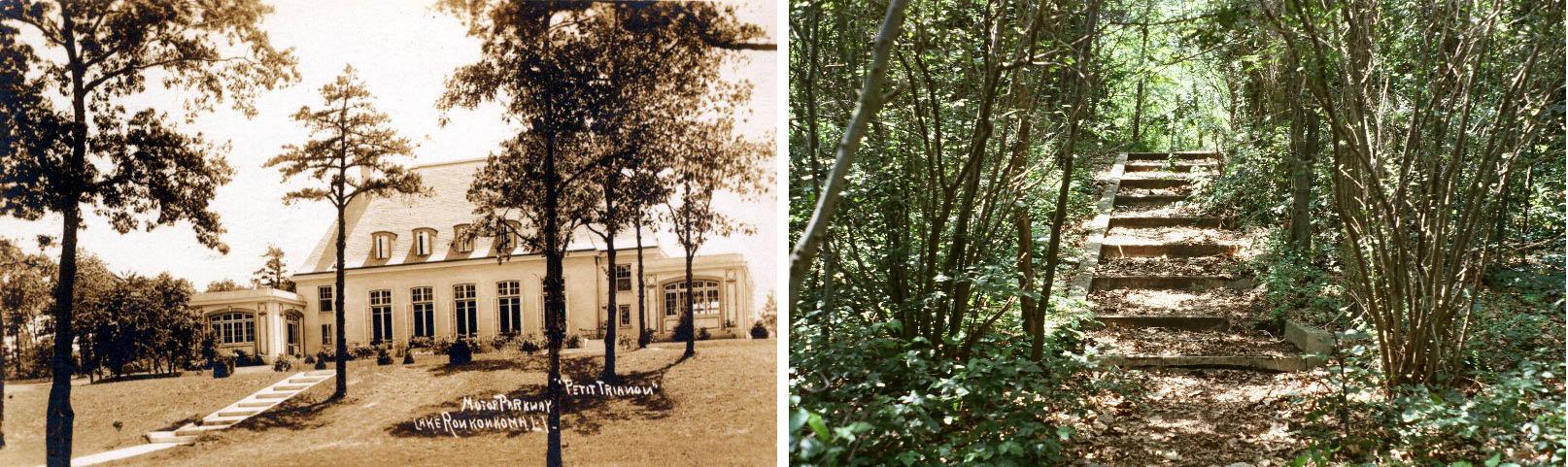
This is a comparison between the 1911 (new) stairs, and Ron Ridolph's 1981 photo of same remnant stairs. I'm convinced they're the same 9 steps after a whopping 70 years! What are your thoughts? These steps may have been eliminated at some point. Concrete doesn't last long in the upper NE snow. THANK YOU RON RIDOLPH!!!
Frank Femenias Update: 2/10/2017:With the help of thed readers, the mystery is becoming clearer. Keep this great thing going, The interaction between veterans and newbies is a remarkable learning experience. There's something about that fragmented 44 mile roadway that keeps us all hanging on.


Comments
I visited the Petit Trianon many times in the 1940s and 1950s…inside and out. The stairs shown are not from this…and there were never any cement blocks used . The concrete walkway went directly from the rear of the Inn ...right into the lake when the water level was high…..no steps ever..and the trees shown are not on the site of the inn, near the beach.
I am very involved in not only the history of Lake Ronkonkoma but am also very active in the Lake Ronkonkoma Improvement Group which has been revitalizing and cleaning the shores of the lake. The homeowners that own the land where the Petit Trianon once stood have destroyed what was left of the original walkway..and dumped it into the lake. We have removed some of it…still have more to do. These people also claimed to own the beach..but we have proven them to be wrong and are proceeding with our clean up all around the lake. To avoid any confusion..there are SOME properties that DO go into the lake…nine in total…and those people have been cooperating with us fully. It was a very sad loss when that beautiful inn was burned…it could have been a wonderful treasure from the Golden era of Lake Ronkonkoma…Thank you, Howard…please don’t take this as criticism…I enjoy all the information you put out and know you try to be as accurate as possible ...and I again thank you for it…
I remember Pine beach, Joan’s beach and Duffield’s beach all around the buildings at the end of Motor Parkway but don’t recall any steps. The lake was a beautiful resort at that time.
Getting more interesting all the time. After reading Harold’s comment I was convinced and disappointed that no rear steps ever existed. Then I came across a 1911 photo and there they are! It appears the rear walkway was replaced at some point including the elimination of steps. But all debris would’ve been entirely removed from the site. So where do today’s steps come from?
The low wall out front on Lake Dr may not have belonged to the LIMP. Although it lines up perfectly towards the former main entrance, another 1911 photo reveals grass where the corner wall should’ve stood (28 feet before the “This Way” entry sign). The space in the photo is greater. Perhaps Motor Parkway installed the wall sometime after? Also revealed in the photo is an earlier diagonal road heading towards the main entrance that no longer exists. That’s about where the wall should be on the left.
Hard to come to a conclusion as things may have changed over the years while still in operation.
Many thanks to Frank and Ron!
Fantastic work Frank. I love the different levels of exploration from initial discovery, inquisitive thought/idea/picture to extensive research to ultimate conclusion. Awesome stuff.
Harold—-there absolutely were steps in back of the Petit. Frank just forwarded a very clear old picture of the back of the Petit clearly showing steps which to me look exactly like Ron’s first picture posted above. I’m hoping Howard will post this picture that was just sent by Frank.
After studying Franks overlay on the current Google map the location where he shows the walkway is EXACTLY where I took my picture of what remains, right behind the easternmost house that is just south of North Drive. Now you might be correct, it might not have been “steps” in this exact location of my picture (Ron’s picture of the steps was right next to the Petit, further away from the water) which is very close to the water but clearly there was a retaining wall here (and is still here) and perhaps this was just part of the cement sloped path leading to the water at this spot. Perhaps my picture of the concrete on the sand is part of this walkway?
And clearly there were concrete blocks used as they are still there! These are certainly remnants from the Petit.
Was there any historical discussion with the homeowner of the Ronkonkoma Lodge prior to the extensive renovation making the house completely unrecognizable to it’s historical past? Were there any findings/relics inside?
Ron’s 5th picture down is the exact same spot as my picture - 35 years earlier.
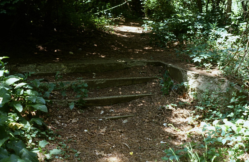
I’m observing Ron’s 1st and 4th photo circa 1981. The crumbling steps in the 4th photo appear to be ending at the shoreline. They don’t look to be a continuation of the steps from the 1st photo. In the rear of the Petit Trianon, the land is sloped to the lake.
The 2 curved pathways meet into 1 short pathway. After this short pathway, the 9 steps are quite clear in the last comparison photo. And then a flat pathway continues on. Not too confuse anyone ( counting myself ), it seems like Ron’s 4th photo ( crumbling steps ) is/was a 2nd stairway that immediately led to the shoreline. It’s not too hard to imagine these crumbling steps to be of cinderblock construction filled in with cement/concrete mix, and then smoothed over with the mix. Maybe these steps are not original from the operational years? A straight path right to the lake continuing after the 9 steps could’ve been utilized as a boat launch? As Harold was saying, the path was removed by the area residents. And perhaps the steps in Ron’s 4th photo were installed afterwards to make it easier to access the shoreline. I’ve walked along the N/S of the lake, but not in this area. There’s quite a drop from the land to the shoreline I remember.
In my previous comment, I referred to walking along the N/S of the lake ( which I’ve had ). I also walked along the W/S of the lake, just not up to this location. The W/S has the abrupt drops from land to shoreline. And it gets a bit hairy on the W/S.
Frank… As always, you do a superb job re-aligning the old and new aerials/locations of LIMP, etc. Found myself viewing the Basemap Gallery on the “gis3.suffolkcountygov/gisviewer/” of this area. Up until the 2001 aerials of this area, #75, 85, and 95 homes weren’t built yet; it was all pretty much woods. So, these homes were built sometime between 2001 and 2004. As you zoom in to this area, there’s a “lined path” extending between the east ends of North and South Dr. And pretty much smack in the middle of this “lined path”, there’s another “lined path” due east to the lake. If Lake Dr. didn’t deadend at Washington Ave, it would head east directly to the “lined path” to the lake. These 2 “lined paths” don’t appear as actual roads on the aerials. These paths are just outside the property boundary of #95 North Dr. ( Like Harold was stating, the residents in this locale don’t own the “lined path” areas ). I know this blog is figured out already, but I felt compelled to express further.
Great find Brian - the Suffolk website is an amazing tool loaded with information. When I first encountered the lined paths near the lake they appeared as proposed roadways, yet mysteriously they’re still labeled today as Beach Rd, and the shorter - due east path, East Dr.) Viewing the website, it’s now clear they serve as zoning boundaries. As Harold indicated, the beach behind the Inn does not belong to the new homeowners (who unwittingly and illegally dumped the concrete walkway into the lake). The Inn’s beach/lake section north of East Dr (2.88 acres total) belongs to the County of Suffolk. The remaining beach/lake section south of East Dr. - and then much more (21.61 acres total), belongs to The Town of Islip. The Petit Trianon’s beach now has two owners. Who would’ve known the future of that beautiful Inn.
Wow! More and more information—keep up the good work.
Ken
Great job Frank, Brian, Dave and all others contributing to these posts. Wonder if the # here will overtake the Mayan Ruins posts from a few weeks back. Glad to see interest in things old as I’m getting there soon enough!
The photo ‘The Petit Annex building circa 1931’ is not correct, the car parked in the front is a 1935 Ford rumble seat coupe. The photo made at or later than 1935.
As I commented last week {?}, I have pix somewhere I took of those steps from ‘way back, ca. 1996 or earlier. They were partly buried in brush but in good shape. Pix of the eastern terminus and Annex at <http://sbiii.com/limpsuff.html#lakeronk>. Sam, III
Checking for new comments (none, yet), I realized that the stairs I remember were closer to PT than Sam and Dave’s as shown on Frank’s satellite view overlay. They were roughly where the “:W” in “WALKWAY” is and fairly-easily accessible from the path/trace shown as the bend in North Dr., although heavily overgrown. Sam, III
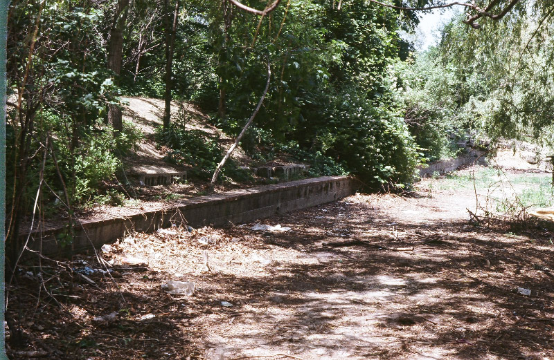
The steps in the 1981 photo are indeed the same steps that were on the walkway behind the trianon. After coming down those steps you would follow the path down to the wall that ran along the shoreline,topped with bricks, that had a staircase down to the beach at each end of the wall. The 2016 photo shows the remains of the south end of that wall along the shoreline, and the remains of the steps that were once there.The lower stairs to the beach were constucted of cinder blocks covered by concrete. The upper set of stairs were constructed out of concrete. The ancient post marking the Southern boundary of the property is still in place just south of the Lower step remains.
From Gary Hammond:
A thought about the Petit Trianon steps remains - the concrete blocks with the bricks cemented on top don’t seem to be of the right period to be original to the 1911 time frame. The 1911 photos show only concrete, so does Ron’s one photo of the original steps in the woods. They seem to be solid, probably poured in wood forms, not concrete blocks with caps. Concrete blocks were being made at that time period, but probably not used for landscape walls at the Petit Trianon. Would be interesting if any of the bricks are marked with the maker - would help to date the age of these remains.
I agree with you on that Gary. The lower wall looks newer than the top steps. Probably a later renovation. Some remains of landscaping walls built at other Pavilions around the Lake in the mid 1920s are built in this block style. This lower wall at the Trianon looks to be slightly newer,possibly mid 1930s. I hope to find a brick with the makers name on it when i visit there next week.
After reading comments from Sam III, Dale, and Gary, I can now picture two drops in the 1912 photo of the circular walkway leading to the lake (photo attached). The drops were not apparent at first sight.
Absolutely, Frank. The 2nd drop/stairway closer to the lake is likely Ron’s 4th photo ( crumbling steps ). And looking at Sam & Daves 1/28/17 blog, I also believe the “concrete/cement slab” is a continuation ahead of the 2nd drop/stairway. I like to think that this slab used to continue towards the lake as a small boat launch. The lake itself was a big attraction back then for recreation, etc.
Brian - According to Harolds post, the walkway entered the lake “when the level was high.” It may have been intended as a boat launch. Not sure about the level rising and falling. I’ve read the lake acts as a water table level indicator as it’s connected underneath to other water bodies in the area, possibly Long Island Sound as well. There are 4 or 5 holes at its bottom with the deepest at ~70 ft at its SW section.
I have to make this comment to set the record straight, the comment by Mr. Harold Sauter on Feb 2017 is completely wrong except for two insignificant comments one being the beach is not owned by the people that live there, he is right, it was never owned by the people but, and a very important but, is the property owners had beach rights, which means they had the right to use the beach and didn’t have to upkeep it, the township had to take care of it. It’s almost better than owning it. The second comment was that some home owners property goes right to the water, this is true, but not in that location.
Mr. Sauder, you said you were inside the Petit Trianon, can you draw a floor plan as you remember it, and send it in? I‘m sure the readers that are interested in the Petit Trianon would like to see how it was.
If not, I can draw you one along with the basement, second floor, third floor, attic and all the surrounding grounds. I can also list some trivia such where the access ladders to the attic were, or the location of the wine locker, the dumbwaiters, or the unlocked doors to enter the Trianon were.
Bob DeStefani
In regard to the comments made that no concrete blocks existed in 1909 when the Petit Trianon was built.
The first hollow concrete block was designed in 1890 by Harmon S. Palmer in the United States. By1905, an estimated 1,500 companies were manufacturing concrete building blocks in the United States.
Read more: http://www.madehow.com/Volume-3/Concrete-Block.html#ixzz4ZRZrAxRD
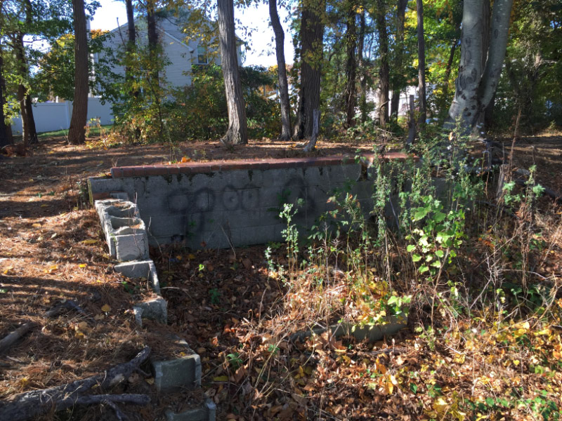
In regards to the construction material used in the construction of the Petit Trianon both reading rooms, the north and the south were constructed of cement blocks and then cemented over, stucco style the main building was made completely out of brick. The terrace was made of cement block with a brick surface as a top layer, debris of the terrace is still on the site. The roof was entirely made of slate. All the walkways and all seven of the stairways were made of concrete. The circular driveway and north side parking area were blacktop. I hope this clears some of the questions of what construction consisted of.
Bob DeStefani
On my last visit to the Petite Trianon lower cement block wall topped with bricks, i was able to determine that those bricks were made by Nassau brick. Nassau brick first produced bricks in 1936. This could suggest a later renovation during the period when Dan Whalen was the operator of the Trianon. Bob DeStefani, I would love to see a diagram drawn by you of where those features were in the Trianon. Your actual kmowledge of the Trianon seems obvious.
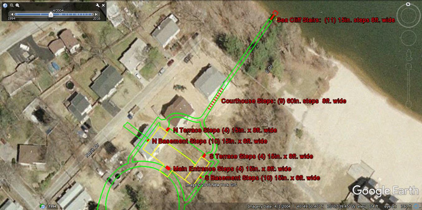
There were multiple stairs all over the back, and front, of this property. Sending Howard an updated map including the step’s location and size dimensions. This update was made possible by childhood resident Mr. DeStefani. A later update will include locations of all remnants that remain on the site today.
I will send sketch’s, as Dave Spencer suggested starting Tuesday or Wednesday this coming week. I already sent Frank Femnias an overhead sketch and advised him that he can share it on this site and I also asked Howard if he can repost my walk through of the Petit Trianon that was sent up in March 2015.
Bob
____________________________________________________
Howard Kroplick
Bob, I will continue the series next week.
Mr. DeStefani…..Thanks for drawing the sketch of The Petite Trianon. You growing up literally right down the street from the Inn and your memories are better than any old aerial or photo can provide.
I’ll be 50 at the end of the month, so I have to rely on aerial maps, etc. I guess the Inn was completed demolished sometime after 1966?
Our family grew up in Brentwood/Central Islip. We used to go to the Islip side of the lake to swim,etc. ( I’m guessing it was safe to be in the lake then? ). I now live in Lake Ronkonkoma with my family. There’s all kinds of warning signs not to swim in the lake.